They are in a strange time of year, the middle of May, as many of us are thinking more about our summer plans, rather then critical questions of local government spending. School board elections, as local elections, are poorly covered by the news, and often are uninteresting. You may no longer attend high school, and you may not have kids in school. Yet those are not good reasons for not voting.
School Board Elections, School Budget Vote, and Library Budget Vote are all important things to vote on for several reasons including:
Low turn out, local elections mean your vote can change results easily.
Your decision hits your pocketbook directly, especially if pay property taxes.
Only chance to directly comment on government spending — should we invest more in our public schools or further increase the crushing tax burden on working folk?
None of us have perfect information. Many years when I vote in school board elections, I don’t even know whose running for school board, and leave those ballots blank. If your concerned about government spending and waste, or think schools and the students being educated are getting cut too much, then either vote Yes or No. It’s that simple.
After the wake of many close elections, one has to wonder if we need more restrictions on voting, to ensure that dangerous people, who don’t fully understand the consequences of voting don’t vote. It’s quite possible that George Bush won in 2000, not because of his abilities to lead our country, but because voters were just plain stupid.
Some have proposed to give local police forces the unilateral authority to decide who gets to vote and not vote on election day. It could be a very simple and straightforward procedure — the chief of police in every town could sign a sheet of paper to make it unlawful for anyone to vote whose name appears on the list.
Why have tough evidence based standards to keep people from voting? Why bother to get a court order, showing a person is mentally unfit to vote? Or if we insist on requiring court involvement, shouldn’t courts be able to keep anyone they want to from voting?
Certainly requiring evidence, beyond a reasonable doubt of a crime committed or about too be committed is too high of a standard. That could allow a lot of people who are of questionable mind to vote in elections. Indeed, even one voter, throwing an election could lead to a totalitarian regime to take over our country. We certainly don’t need any more tragedies like George Bush getting elected.
People make similiar arguments about gun control, so why not voting? Doesn’t this sound very democratic and fair to give government lots of arbitrary control over who can vote?
You often hear commericals on radio that “Subrarus are made in zero landfill factories.” Basically, what they are talking about is their automobile assembly factory, where manufactured components are shipped in reusable containers (to save money), bolted or welded together, and finished up.
They do not include manufacturing of components, or the mining of raw materials to build the cars. Even at zero-landfill assembly factories, some waste is generated, but valuable metal scraps are sent to scrap dealers, and plastic garbage and other wastes are shipped off to municipal trash incinerators, and burned for energy. Zero-landfill Assembly factories typically also have recycling programs in lunch rooms for aluminum cans and recycling for paper in offices, which is fairly common in most industries.
When you read into the claim, you have to be kind of skeptical. Indeed, zero-landfill is much different then zero-waste, or near zero-waste as many environmentalists are persuing. Indeed, much of it’s just certification, rather then any real change in process — as it’s stupid not to reuse shipping containers, scrap waste metals, and do other things that save businesses money.
Zero Landfill Camping.
I don’t generate any trash when I camping that I haul home, and then take to the transfer station for disposal in a landfill. I seperate out the burnable trash from the non-burnable trash, the later which I take home for recycling either for remedemption of the deposit or regular municipal recycling at transfer station. I don’t leave any waste behind, and indeed, I often pick up litter from other persons, including small scraps of paper or plastic people overlook.
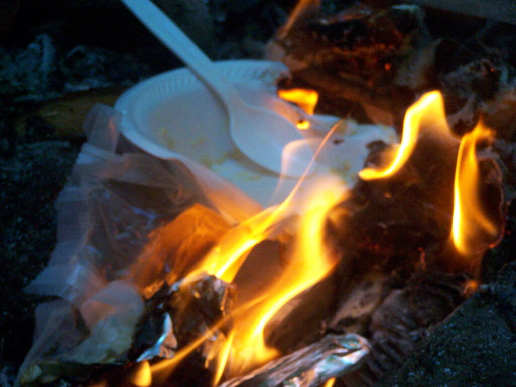
I do use styrofoam plates and plastic forks, paper towels, wet whipes, and often camp food comes in more packaging then stuff you get a home, as more stuff is canned or in dry packaging. I don’t use reusable bags when buying camp food, because having lots of plastic bags is handy for camping. It’s a lot easier to burn your trash, then have to wash up a lot of dishes. Food waste is also burned in a hot fire, because one doesn’t want attract bears.
I generate a lot more trash at camp then I do at home. Yet, I don’t want to haul a lot of smelly trash around, so the garbage gets burned at the end of the evening in the campfire. The day’s plastic bag full of burnables gets burned in the hot campfire at the end of day — and is almost instantly incinerated. I like watching trash burn, and I’m not that worried about it compared to what a lot of farmers and rural folks in more rural states burn regularly in their burn barrels and pits.
Tin cans are burned out, to rid of food residue, and tossed in the bin with the aluminim beer and beverage cans. Glass bottles are washed out. Anything that doesn’t burn is hauled home for recycling. I make sure to pick out any aluminum foil or partially burnt trash out of the fire pit. I don’t litter, and there is no trash generated that ever sees a landfill.
Mocking Zero-landfill Concept.
To a certain extent I am mocking the concept of zero-landfill manufacturing, that some manufacturers like to brag about it. Are farmers and rural residents who burn their garbage, recycle tin cans and glass, compost, zero-landfill folk? They are keeping their waste out of landfills after all.
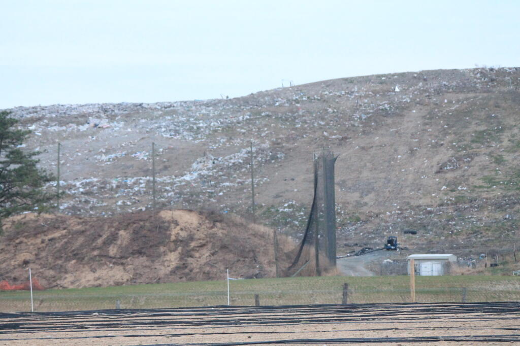
But more seriously, it’s not zero-landfill but zero-waste we should be getting to as a society. It’s one things for a country boy out in the boonies to burning his garbage in a fire, it’s another thing for an urban society to be taking steps to reduce it’s waste. All of the country boys, farmers, and rural residents of the world, generate relatively little trash compared to what our big cities generate.
Cities need to find steps to recycle more of their waste, and recover their organics through source-seperated organics composting, biogas, or source-seperate organic biomass energy production. Cities need to find ways to keep their organic waste seperate from toxic technical materials — we got to stop dumping massive quanities of plastics and metals mixed with organics like food waste and brush into massive garbage incinerators and landfills.
Census Block Equivalency – A list of census blocks in each district, generated by the commerical GIS program (such as Mapitude) used for redistricting.
Metes and Bounds – A legal description of each district, used in resolving court disputes over district boundaries, and assisting board of elections on where to put voters whose property might be crossed by a Census block
If you planning on making a map, Metes and Bounds won’t be particularly useful. Computers don’t understand english very well, they need numbers and lists. In contrast, the Census Block Equivalency is very useful for mapping things.
Every year, the Census Bureau puts out series of ERSI Shapefiles known as TIGER/Line. You can download TIGER/Line for any state and county in the United States from their website. They provide many different shapefiles and layers such as a Highway, Faces, Edges, and County Subdivision layers, however the one you will be most interested for making district maps is the Tabulation Block (tabblock) layer.
You can use these files in the free program known as Quantum GIS or QGIS. While this tutorial will not explain the ins and outs of QGIS, this should get you started on making redistricting maps.
The Tabulation Block Layer is the file containing all of the Census Blocks for a particular county. A Census Block is the smallest unit of population gathered by Census Block, and consists of all bordering features (bounds) — roads, rivers, shorelines, along with all imaginary lines (metes) — town lines, village lines, other lines drawn for statisitical purposes.
Each Census Block has a number, that is a subdivision of the Census Block, County ID, and State ID that it resides within. For example, the Governor’s Mansion in Albany is located in Census Block 2000 in Census Track 23.00 (zero padded to 002300) in Albany County (Federal Information Processing Standard — FIPS ID: 01) which is in NY State (FIPS ID: 36). County subdivisions are not applied to Census Tract Numbers, as they may in some cases cross county subdivisions, as is the case of smaller districts.
You put those numbers together to get the GEOID — which is the key used for redistricting block lists and most other block-level census data. The Governor’s Mansion is located at a block with a GEOID 360010023002000.
36
001
002300
2000
State ID
County ID
Zero Padded Census Tract Number
Census Block Number
The block list you get from a redistricting commission typically is in Database Exchange Format (.DBF) or Comma Deliminated Format (.CSV) which are both openable by common spreadsheet applications like Microsoft Excel or OpenOffice Spreadsheet and GIS programs like ArcGIS or Quantum GIS.
This is taken from the LATFOR State Senate Proposed Districts (January 2012) DBF file. It shows you that the Governor resides in Proposed Senate District 44. Across the river in Census Block 4010, Census Tract 524.03, in Rensselear County (FIPS ID 83), NY State (FIPS ID: 36) is located in Proposed Senate District 43.
360010023002000
SD44
360010021002008
SD44
360010021002004
SD44
360010021002001
SD44
360830524034017
SD43
360830524034010
SD43
Download the TIGER/line “Tabulation Block” Shpaefile file for the district you are interested in. You will want the 2010 version. You can download a state-wide tabulation block file, however that is not recommended as the next step will be impossibly slow on most computers. You may also want to open the .CSV or .DBF file in your spreadsheet program and cut out the county you want to speed things up.
You will then want to open up the file in Quantum GIS. You will get a nice map of the county you downloaded, showing all of the Census Blocks.
From there, go to the Vector -> Join Attributes submenu.
Make sure that the Target vector layer matches the Tabulation Block Shapefile you wish to join against, then set Target join field to GEOID10 .
Select click Join dbf table and select the DBF or CSV file you wish to join.
Change the Join field to BLOCK or whatever the GEOID is titled in your redistricting block file.
Enter in a location to save the Output Shapefile
Click okay.
Then wait. A typical county will take 10-40 minutes to join on my 5 year old laptop; your computer may be quicker. If you have a dual processor machine, go on to doing other work in other programs. You will end up with a map that looks like this (stylized for your enjoyment). Each block will be assigned a Senate District (in this example).
Halfway there. Now you need to “dissolve” each Census Block into it’s larger political district. Go to Vector -> Geoprocessing Tools -> Dissolve . Set the Input vector layer to the file you previously joined. Then set the Dissolve field to the field containing the district number — such as DISTRICTID or whatever it is named. Enter a name to safe the file. Click Dissolve.
Outputed will be a Shapefile containing all the political districts in the county you joined and dissolved. This will take 5-20 minutes on my laptop. Other data may exist in that file, such as Census Block number, however at this point that data will be invalid, as only the district number is accurately preserved in such a join. All other data will be picked at random, so delete those columns.
I hope this is helpful. If you just want the Proposed State Senate or State Assembly Districts you can download them from Center for Urban Research. These are the same data, joined using the above process by somebody with a much faster computer. I have also made up a Shapefile containing the Albany County Legislative Districts using this process.
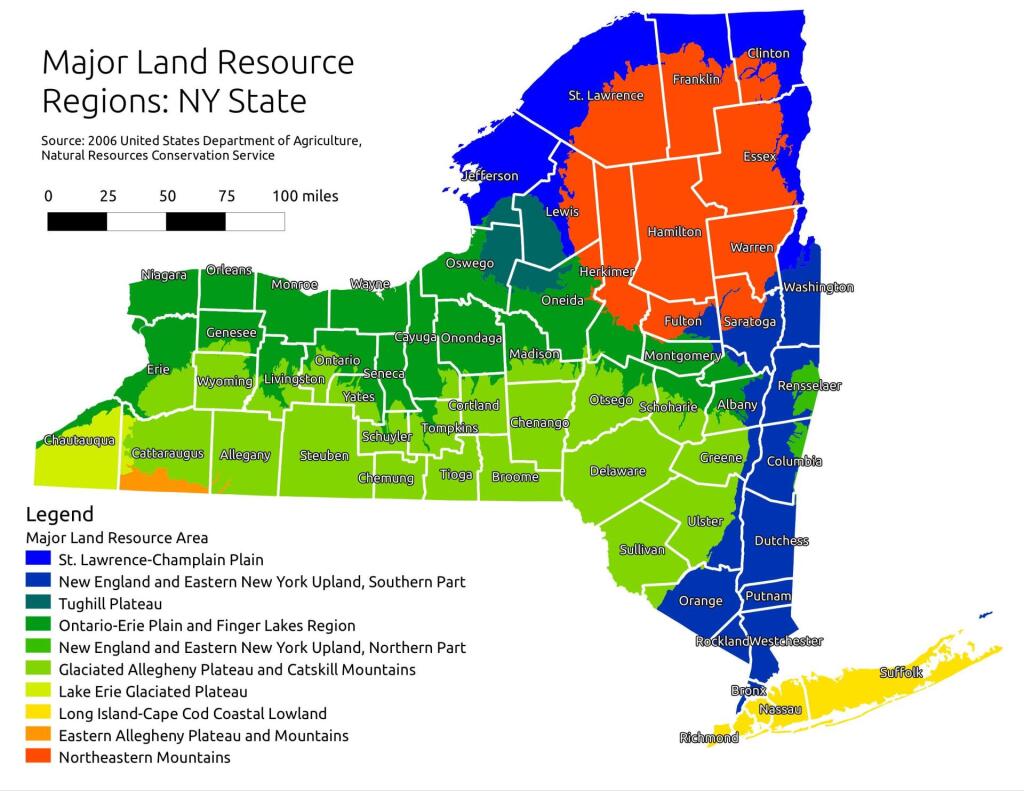
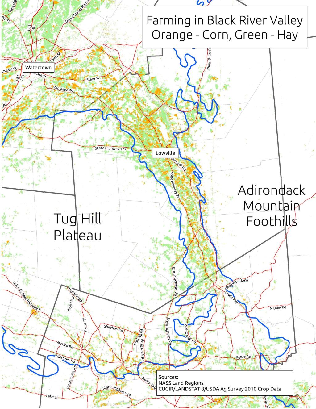
When I was younger I used to think of the Tug Hill Plateau as a vast agricultural region. It really isn’t. There are farms in Black River Valley, but not so much up on the Plateau, especially as you gain elevation.
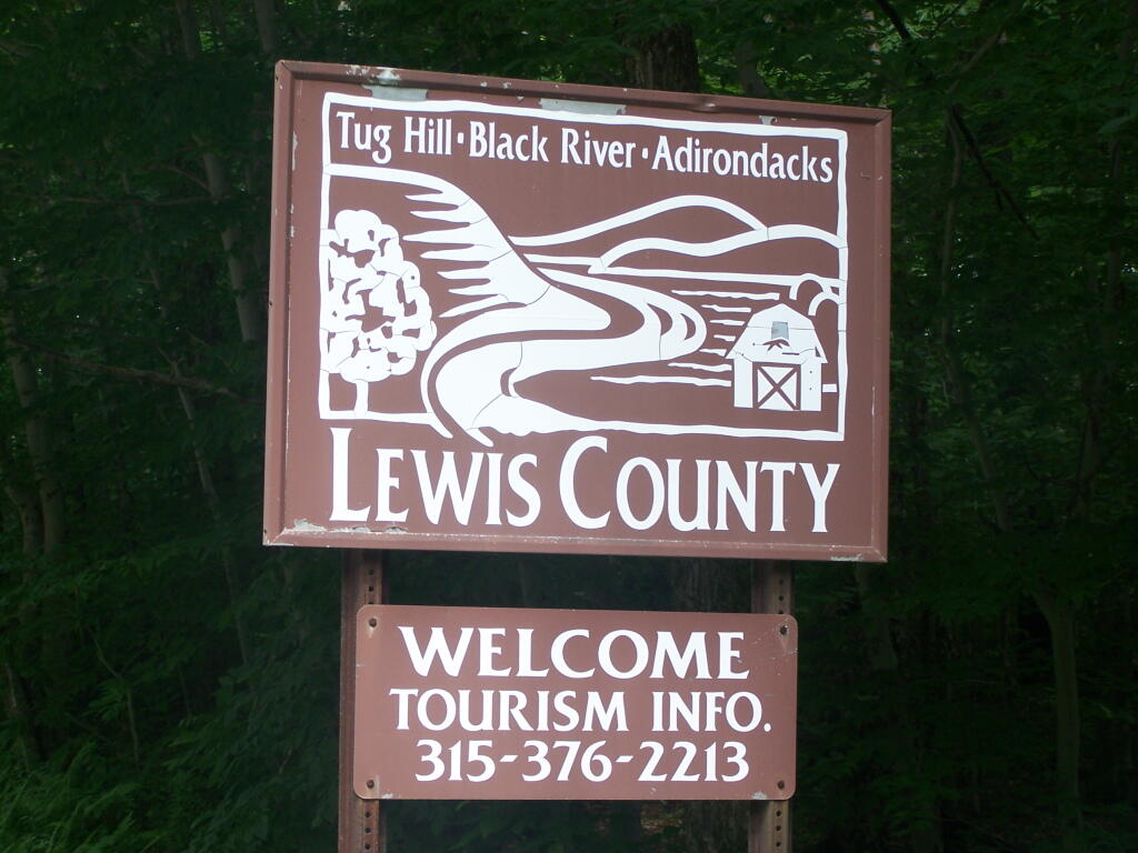
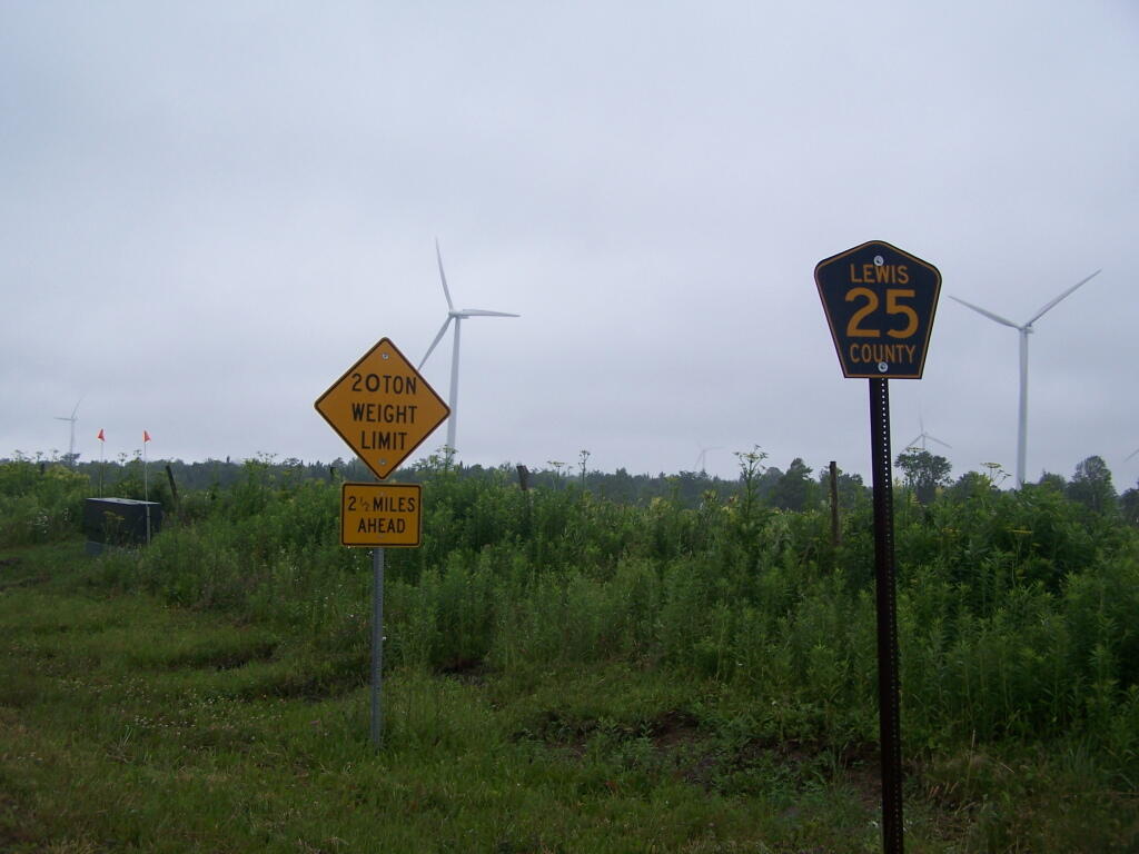
The signs going into Lewis County say “Adirondacks-Black River-Tug Hill”, and except for that relatively narrow band running along the Black River, Lewis County doesn’t have a lot of farming — much likes the rest of Tug Hill Plateau.
An elevation map of NY shows that most of the Tug Hill Plateau is between 1,000-2,000 feet elevation, but that’s high enough in NY to make agriculture unprofitable in most of state due to short growing season.
The Black River Valley, with it’s fertile soils notched between the Adirondack Foothills and Tug Hill Plateau make Lewis County a major agricultural producer, with 262 dairy farms, including some of the largest in state. The area around Lowville is excellent agriculturally, until you start back up in to the hills on both sides with their short growing seasons. Dairy farming makes up 20% of the land use in Lewis County (per 2010 USDA NASS), but almost all of that occurs in Black River Valley or slightly up the slopes of Tug Hill Plateau.
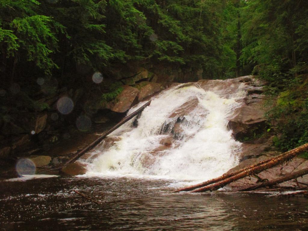
In many ways the Tug Hill Plateau is a fascinating region of the state. Unlike the Adirondack Park, only a relatively small portion of it is publically owned. About 2/3rds of it is private timber lands, with rest being public lands. It lacks any major cities or population centers, much of it is roadless, or where roads exist, they primarily service hunting camps or timberlands.
The remoteness of the Tug Hill Plateau remains a real fascination for me.
Sure a car will rust and decay, fall apart, and be another junker. One might say it’s a waste of money.
When cars are not being driven solely for pleasure, they are the most miserable beasts, forcing one to follow extreme restrictions and control measures, doing nothing but forcing us to labor for meaningless waste.