Search Results for: photo campsite 2 2

Delightful Fall Hikes

Pillsbury Mountain (Central Adirondacks).

Located in the Jessup River Wild Forest, North of Spectulator, offers great views of West Canada Wilderness, Cedar River Flow, Moose River Plains, Spectulator Tree Farm, Siamese Pond Wilderness. Should be close to peak foliage now. Consider camping at the roadside/tent campsites along Mason Lake to the North on Jessup River Road / NY 30. Take NY 30 to Jessup River Road to Military Road to Parking Area to get there. You may want to park at the start of Military Road if you have a low-clearance vehicle.

Snowy Mountain

Click on map to download and print.

 Hogsback State Forest

Hadley Mountain (Southern Adirondacks).

Located near Stony Creek, NY, it offers some great views of the Wilcox Lake Wild Forest and the Great Scanadaga Lake. I’ve never been there in the fall, but I suspect it offers many great views this time of year, with peak foliage being not far away.

Looking North

Click on map to download and print.

Gully

Buck Mountain (West Shore Lake George, Adirondacks)

This is one of my most recent hikes, but definately offers really good views of Lake George and elsewheres, especially now that the fall colors are starting to set on in. One of the more difficult hikes on the list, it’s not really that difficult, but if you go from Pilot Knob, expect a 3.1 mile hike, and gaining around 2,100 feet in elevation. Regardless, a very nice hike.

2022 NY Congress Results Map

Click on map to download and print.

Route 9 & 20 in Rensselaer

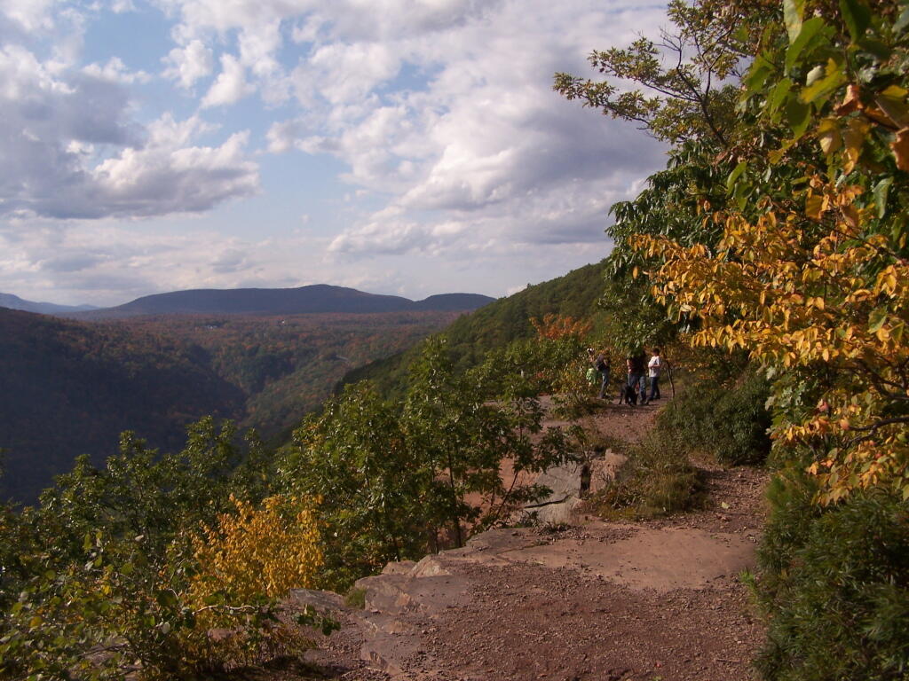
Kaaterskill Clove (Haines Falls, Catskills).

Located near the North South Lake Campground, offers great views of the Clove, Hunter Mountain, Palenville, Hudson River, and farms and other lands near Catskill. Park on Scutt Road for free, which is last right before campground. Take Escarpment Trail all the way around to the Catskill Mountain House Ruins, then walk past North-South Lake.

* Area may be temporarily be closed due to Irene.

Inspiration Point

Click on map to download and print.

 Ferns Covered Woods

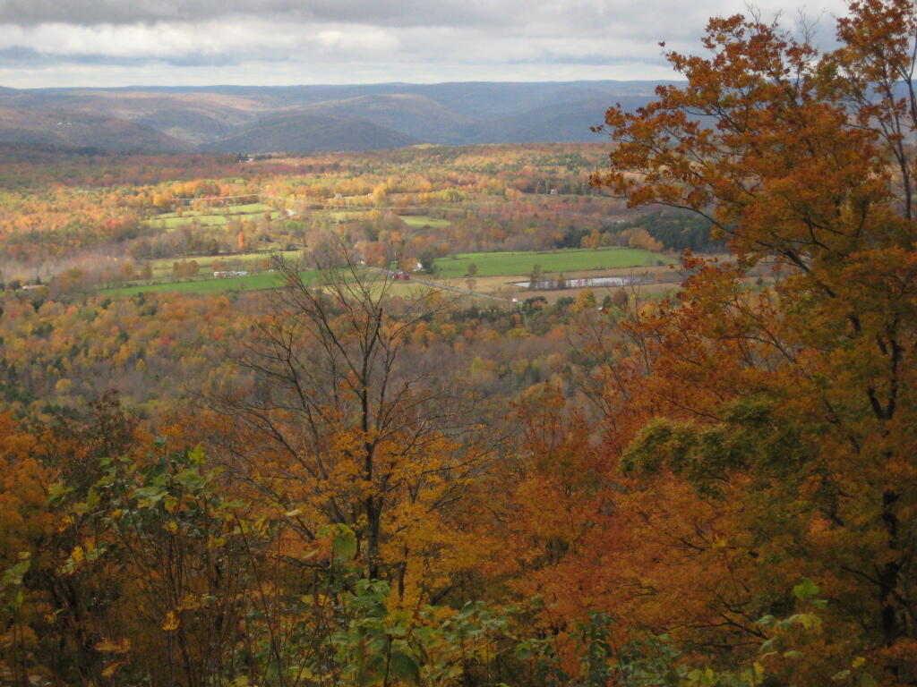
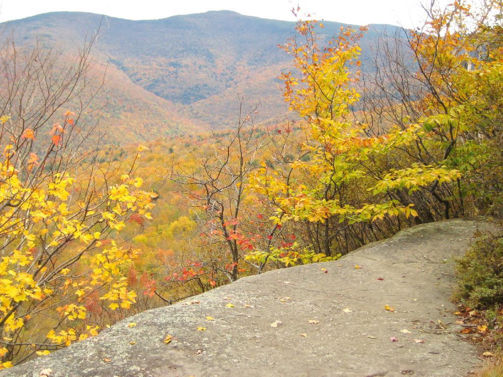
Giant Ledge (High Peaks, Catskills).

Located on the ledge between Slide Mountain and Panther Mountain, a relatively easy hike, with a relatively brief but not scary scramble onto the ledge that runs for 3/4 mile. Colorful views of vast Woodland Valley with Mount Tremper and other mountains in the distance, along with good views of Slide Mountain, Cornell Mountain, and other hike peaks.

* Slide Mountain Road was severely damaged by Irene. Area may be temporarily be closed due to Irene.

Untitled

Click on map to download and print.

When Thanksgiving Falls, 2000 to 2099

Camping on Hope Falls and Pumpkin Hollow Roads

There are several campsites a on side roads, little ways off of NY 30, as you head North from Northville towards Wells NY. These campsites are nice if you starting off into the Adirondacks, and are looking for a convenient place to camp for the night, and want campsites quieter then those on NY 8 / East Sacanadaga River.

These sites are all designated with official “Camp Here” discs.

Road Number of Sites
Hope Falls Road 3 Vehicle
3 Tent Sites
Pumpkin Hollow Road 2 Vehicle (Between Willis Lake and Inholding)
1 Vehicle (Beyond Inholding)

Hope Falls Road.

From Northville on Hope Falls Road, you drive north and north. The paved road goes on for several miles, until you finally reach the “Seasonal Use Only” sign, and hte pavement ends it becomes a one lane road.

 Hammond Pond Wild Forest - Green Hill Parcel

Click the map above to print it.

None of these campsites are particularly fancy, although there is a single outhouse for the first grouping of campsites on the southern port of the road.

Gulls on the breakwater

All of the campsites run along Stoney Creek …

Stoney Creek

Pumpkin Hollow.

The campsites are a ways back on Pumpkin Hollow Road, a dirt road, beyond Willis Lake and the camps along it. Pumpkin hollow is a short ways south of the Sacanadaga River DEC Campground, it starts out as a paved road by a white house, then eventually a mile or two back becomes unpaved and one lane.

Blue skies

You can print the above map by clicking on it and printing it.

Willis Lake

Here’s sample designated campsite on Pumpkin Hollow Road.

Designated Campsite

And Pumpkin Hollow Road…

Pumpkin Hollow Road

Kayaking Long Pond

Long Pond offers 8 designated roadside campsites, and a handful of other informal campsites on the other side of the lake. A large man-made lake in an agricultural landscape of Chenango County, it offers some excellent fishing and nice views, especially for Chenango County.

Reed Hill

This map below shows where each picture was taken roughly in the area.

Farm on North-West Side

Flower on Lake

Barn Along NY 41

Rain Drops

Bailed Hay Along Pond

Flowers

Dolph Pond State Forest

Great Blue Heron

Finally Starting to Clear!

Timber Planation Along Long Pond

Blue Skies

Checking the Map

Clearing

Hatch Brook Falls

Dam at End of Lake

 Fields

White Birch Planation

West from Dam

Campsite 7

Golden Rod

Golden Rod, Trees, Clouds

Evening Sun Peaking Out

Rays Hitting the Pond

Backlit

Evening Sun Peaking Out

Sunset on the Lake

Sun Rays

Reflections of Sun

Floodwood Loop in St Regis Canoe Area

On a nice weekend, expect many people to be joining you on the ever popular Floodwood Loop in the Saranac Lake Wild Forest. While technically not part of the Saint Regis Canoe Area, this area is considered part of series of ponds that makes up this area, and this loop is the most popular of all the canoe routes in this area.

Big Alderbed

Alternatively, take a look at this Google Map of the loop. Balloons are designed campsites, there are no charge to use these sites. Red lines are portages and other trails.

At around 10 AM I headed out. Bright sunny day, a lot of glare. None of the ponds are paticularly large.

Heading Out on Floodwood Pond Loop

The Fish Creek between the ponds is quite narrow, and don’t be surprised if you hit some traffic. In parts the current can be fairly swift, although one can still paddle up or down stream with relative ease, just avoid the other boats.

Fish Creek

Heading Into Little Square Pond

Little Square Pond

Bright Day on the Lake

Spatterdock on Fish Creek

Coppreas Pond

Heading Across Coppreas Pond

Traffic on Coppreas Pond

Canoe Carry to Whey Pond

There is a 1/4 mile portage between Copreas Pond and Whey Pond. Despite being mostly sandy soil, with some roots, do NOT drag your kayak, if you want to avoid putting holes in it, as I learned the hard way.

Poliwogs on Whey Pond

Trees Along Whey Pond

Out on Whey Pond

Paddling Across Whey Pond

There also is another short portage over a road, and through the Rollins Pond Campground, after you leave Whey Pond.

Passing Rollins Pond Campground

Heading Across Rollins Ponds

Traffic on Rollins Pond

Past Swimming Beach at Rollins Pond

Narrow Passage Between Rollins Pond and Poliwog Pond

Back Out on Floodwood Pond

Towards St Regis Mountain

St Regis Mountain

Parked a Campsite on Floodwood Pond

Designated Campsite on Floodwood Pond

Private Kayak

Small Island

Heading Back Into Shore

Overview of the Saint Regis Canoe Area, including other ponds and all of campsites.

At the Shore

And if you prefer roadside camping with a trailer or pickup truck cap, take a look at these sites.

… I hope you enjoyed these pictures and maps from the Floodwood Loop.

Burnt-Rossman Hills

The largest parcel of state lands in Schoharie County Burnt-Rossman State Forest. While containing some inholdings, consisting of hunting camps and other rural residents, this 10,588 acre parcel is massive, rural, and consists of nearly 20 miles of unimproved roads and truck trails.

Sun Altitude from Horizon

Here is Burnt and Rossman Hills, the rolling flat hills in the distance on the right, as seen from Leonard Hill.

Towards Emminence

Consisting of a portion of Burnt Hill and most of Rossman Hill, it has many interesting forest tracts, with roads winding through them. The roads are dirt and rough in many places, but they take you to secretive little campsites like my favorite two sites on Betty Brook Road, the well hidden informal campsite, 100 feet CC Truck Trail, and the campsite on Duck Pond. There are also other places where people have camped in the past that are quite delightful, such as informal sites along lower Betty Brook Road.

Stone Table

For those who like to explore the woods, there are few lands as wild and underused as these lands. Some locals come to camp, hunt, and fish these lands, but there are many days when you can be up here are not ever run into another single person. You might see one old pickup truck or somebody riding horseback over a weekend, or you might be totally alone in complete solitude. It is a wonderful place.

Lean-To Side

The Pros and Cons of Getting a Camping Permit

New York State requires you to get a camping permit if you stay in a spot or a campsite for more then 3 nights. I have never bothered to get a permit, unless the rare times I see a forest ranger, and he asks me to fill out a camping permit. I generally do not get camping permits, because I don’t stay more then 3 nights in any one spot – if I was a hunter, setting up a base camp in big game season – it might be different.

Pros.

  • It shows that you are using the land, providing justification for the DEC to spend more funding on that piece of land versus another piece of land.
  • It’s nice to stay at one site for an extend period, if you plan to stay in that general area, so you don’t have to pick up and remake camp every couple of night.
  • You don’t have to necessarily camp at a designated spot or farther then 150 feet from road or water if you get the permit for another place.
  • In case you are reported lost or injured, the forest ranger knows where to look.
  • There is no charge, and all you have to do give forest ranger a call with your license plate and other basic information.

Tent

Cons.

  • You have to plan where you are going a couple of weeks in advance to give the forest ranger a change to mail you the perm
  • Staying in one place leads to more wear on the campsite.
  • It can be be boring to camp in one site for an extended period.
  • Do you really want to tell the government where your camping, so it can track you?

Camping Down By Otter Brook

… in many ways the cons are longer then the pros.

A Place I’ve Overlooked

Over the years I have spent a lot of time camping in the Catskills and Adirondacks. I sometimes go out to Finger Lakes or Central NY, or drive down to Pennsylvania to the Tioga State Forest or Allegheny National Forest. Yet, except for one trip in 2004 and in 2008, I have not spent much time at all in Green Mountains.

Kelley Stand Road

I have my reasons for not going to the Green Mountains National Forest. For one, the drive from Albany to Bennington Vermont, is a punishing and awful drive, especially prior to the construction of the Bennington bypass. Hoosic Street in Troy is an awful during most hours of the day, and there is few alternatives for one wanting to get from Albany to Bennington. NY 7 is always congested and loaded with poky speed traps.

71 degrees in Albany this morning

Yet, besides the driving difficulties, there is a lot in Green Mountains. They are not the Adirondacks, but you get back off of Kelley Stand Road, get to some of the many ponds and waterways, mountains, and other wild lands, one must wonder why one hasn’t spent more time here. It’s only 50 miles from Albany to the entrance way of Green Mountain Forest, and there are many wonderful free campsites. It’s pretty wild back here, but still that drive is awful.

Buffalo University District - Percent African American

I don’t know. I should use my cartography skills and try to find alternative routes to Green Mountains. Maybe take the Northway North and cut over, well North of Troy. Or go through a more southernly route. Yet, at any rate, as an alternative to Adirondacks or Catskills, and is out of State, the Green Mountains National Forest seems like a great place to visit.

Original Dunn Bridge