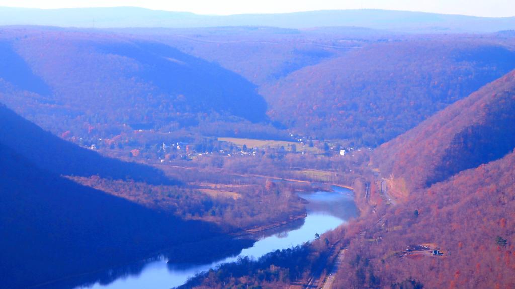
Balsam Swamp is a sprawling state forest that stretches almost 5.5 miles east-west across 4 towns. The area is very rural, and the landscape surrounding the State Forest is predominantly forested. Balsam Swamp State Forest is comprised of a mix of native hardwood forests, hemlock swamps, and conifer plantations. There are no designated recreational trails on the forest, but there is ample opportunity for self-guided day hikes to explore the diversity of habitats represented on this State Forest. Additionally, the western section of Balsam Swamp State Forest is adjacent to Five Streams State Forest to the south.
The main attraction of this forest is Balsam Pond. The impoundment is approximately 152 acres and is a popular destination for fishing and paddle boat sports. Balsam Pond is a warm water fishery that contains a mix of largemouth bass, smallmouth bass, chain pickerel, yellow perch, brown bullhead and sunfish. Tiger muskellunge have been stocked in the past with the last stocking occurring in 1995. However, there have been very few reports of anglers catching any of the adult tiger muskies. A shallow gravel boat launch is suitable for launching small fishing boats.
A small rustic camp ground is also located at Balsam Pond. Camping spaces are available at no cost on a first-come, first-serve basis and there is no running water or electricity. A fire ring, outhouse, and picnic table are provided for each camping space. A sign on Balsam-Tyler Road in Pharsalia designates the entrance to the boat launch and camping facility. This is a carry-in carry-out facility. Please do not litter.
People were asking how I was extracting the digital terrain model (tree/building elevation) from the NYS GIS LiDAR point clouds (LAS) files. While the digital surface models (bare earth) models are widely available in raster digital elevation model GeoTIFF, these files are bare earth and don’t include vegetation or buildings. But you can easily create raster digital elevation model GeoTIFF from the LIDAR point clouds with the PDAL – Point Data Abstraction Library.
Install PDAL
It’s easy if you are running Ubuntu Linux — it’s in standard distribution with 20.04 LTS or later. Most modern distributions of Linux include it in their repositories.
sudo apt install pdal
Download LiDAR Point Clouds
You can download the individual cloud files from NYS GIS FTP site. You can use the LiDAR Shapefile indexes on that website to figure out which file you need. Be aware you may have to download and store a significant amount of data — each roughly 556 acre tile (less then a square mile) is between 500 and 1,000 MB. So you will want to do this somewhere you have a lot of free unlimited data service and storage on your hard drive. And patience while it downloads.
Extract the Digital Terrain Model
You should create a text file called pdal_dtm.json or something similar. The text file should contain:
This creates the pdal “pipeline” configuration file for the conversion. An explanation of important lines you will need to change:
“18TWN220520.las” – Input point cloud LAS file “type”: “filters.range” – Tells PDAL to filter points based on request “limits”: “Classification[1:1]” – Layer to extract * “filename”:”dsm.tif” – Export file name “gdaldriver”:”GTiff” – Use GeoTIFF export (same as standard DEM files) “resolution”: 0.5 – Resolution in meters for export, typically 0.5m or 1m depending on survey “output_type”: “max” – Highest point reflected back within that point, to get digital surface elevation. You can also use min/max/mean/count/stdev/idw. “type”:”writers.gdal” – Use the GDAL library for create GeoTIFF
* Layers in NYS GIS Point Clouds – “These point clouds will have at a minimum 2 classifications; Class 1 Unclassified, and Class 2 Bare Earth.” Layer 1 is the digital surface model, it contains building heights and tree/crop cover. Layer 2 “Bare Earth” is the same as what you get from the LiDAR Digital Elevation GeoTIFFs that are widely available on NYSGIS website. Be aware that the Class 2 points may have no-data areas, where no ground elevation was detected due to tree cover or other things blocking ground. The DEM files you download from NYSGIS have these areas filled in with interpolation from surrounding areas.
Once your configuration file is done, run the command:
pdal pipeline pdal_dtm.json
As the Point Cloud files are internally indexed, the export should take only a matter of seconds on a modern desktop computer. The exported DEM/GeoTIFF file will be between 15 to 25 MB, which is much smaller then the point cloud. Then you can load in Quantum GIS or your favorite non-free software GIS client like any other Raster DEM file.
To calculate the building or tree height, just subtract the Class 1 raster from Class 2 raster, using the Raster Calculator in QGIS or your favorite GIS program. Or better yet, subtract Class 1 points from the already processed DEM files on NYSGIS website, as they have the missing bare earth data filled in.
Brown in many ways is the color of April. The dirt and ground is brown or gray, with the snow mostly gone but still too cold for things to green up in the more upland areas. Mud and muck get on the boots, the air often has a pungent taste to it in farm country. The warmth of May sometimes breaks through in April, but color is limited, for this is not a month known for it’s diverse color.
You know I was thinking a bit about what I really crave — that small town feeling, the kind you get when you are in “deep rural” beyond the commuting distance of the nearest big city. Isolated, away from the problems of the big urban city. It’s possible to get “out in the country” and live in a rural area but until your past that 30 mile mark from downtown, it really doesn’t feel particularly special or unique.
The problem with the Albany metropolitan area is it’s an area of 1.1 million people. You have to get pretty far out before you’re not essentially in the suburb of Albany. While you have rural land not too far from the south-east or west, a lot of it is residential commuters back to city until you get pretty far out. It’s suburban housing between the farms and houses for much of the rural areas not far from the city.
I can travel to many of those small towns, and it’s fun to vacation there, but I do wish I could live in a place like one of those little towns. I just need to figure out how to get from where I am now to there, so I can have feeling every day.
Fruits, vegetables, whole grains and beans! Doesn’t have to taste bad – you just need to experiment with spices and cooking it appropriately. After a few months, eating things without much fiber becomes so bland and uninteresting as you grow to love food with texture and structure! Chewing is good.
The other day I had a piece of white bread – yuck when you’re not used to eating things like that. I want my food to have flavor and texture!
People talk about smoothies with all that added sugar being good. I guess in fifty years when I’m in the nursing home in my last few hours on a feeding tube they’ll be good but I’ll have an apple or carrot today while I still have teeth.
“Congress shall make no law respecting an establishment of religion, or prohibiting the free exercise thereof; or abridging the freedom of speech, or of the press; or the right of the people peaceably to assemble, and to petition the Government for a redress of grievances.” ~ First Amendment of the United States Constitution