Balsam Swamp is a sprawling state forest that stretches almost 5.5 miles east-west across 4 towns. The area is very rural, and the landscape surrounding the State Forest is predominantly forested. Balsam Swamp State Forest is comprised of a mix of native hardwood forests, hemlock swamps, and conifer plantations. There are no designated recreational trails on the forest, but there is ample opportunity for self-guided day hikes to explore the diversity of habitats represented on this State Forest. Additionally, the western section of Balsam Swamp State Forest is adjacent to Five Streams State Forest to the south.
The main attraction of this forest is Balsam Pond. The impoundment is approximately 152 acres and is a popular destination for fishing and paddle boat sports. Balsam Pond is a warm water fishery that contains a mix of largemouth bass, smallmouth bass, chain pickerel, yellow perch, brown bullhead and sunfish. Tiger muskellunge have been stocked in the past with the last stocking occurring in 1995. However, there have been very few reports of anglers catching any of the adult tiger muskies. A shallow gravel boat launch is suitable for launching small fishing boats.
A small rustic camp ground is also located at Balsam Pond. Camping spaces are available at no cost on a first-come, first-serve basis and there is no running water or electricity. A fire ring, outhouse, and picnic table are provided for each camping space. A sign on Balsam-Tyler Road in Pharsalia designates the entrance to the boat launch and camping facility. This is a carry-in carry-out facility. Please do not litter.
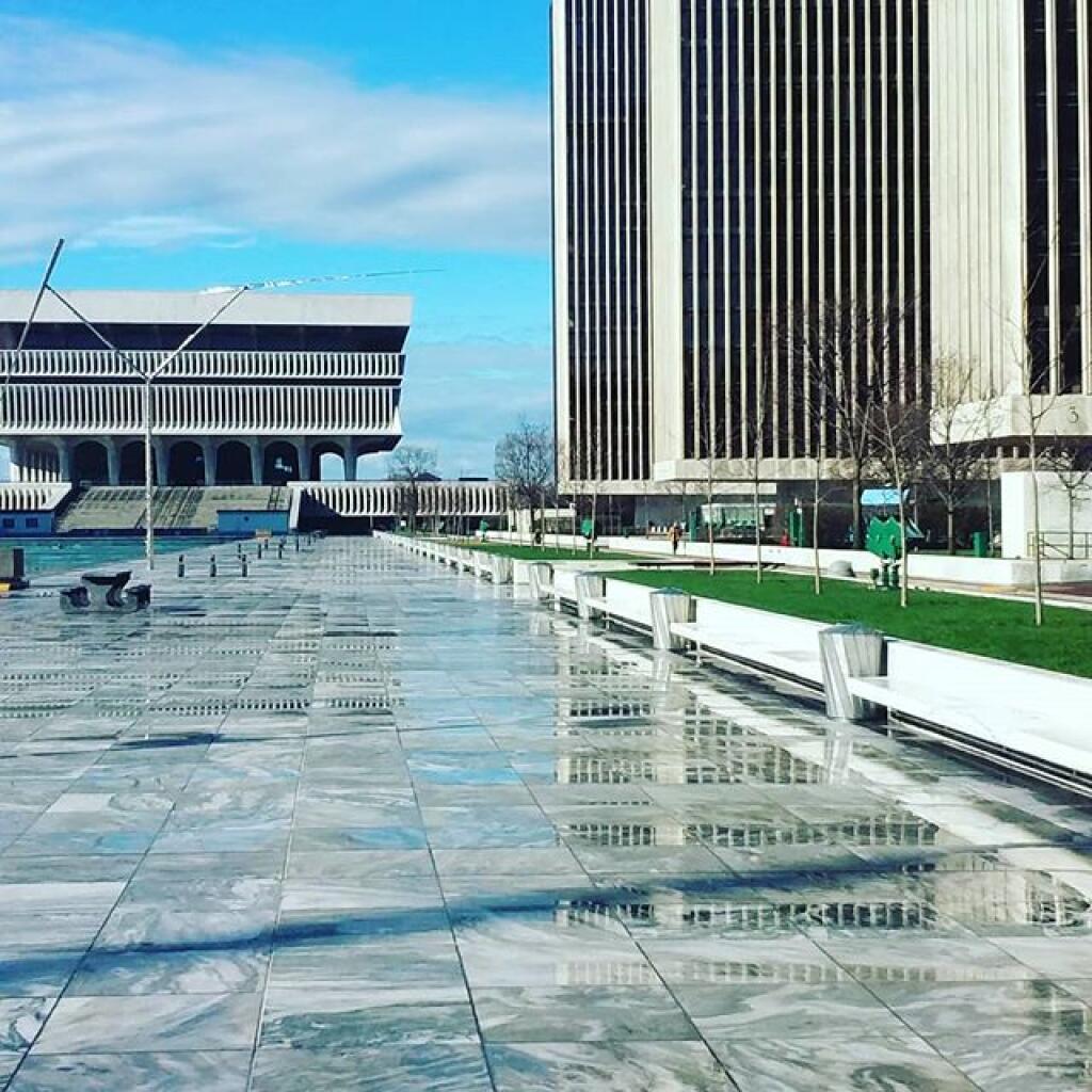
The Empire Plaza and connected buildings (Alfred E Smith and Capitol) use 111 gigawatt hours of power a year (electricity only, doesn’t include fossil heating or cooling).
To build a solar farm to power the Empire Plaza it would require demolishing 320 acres of buildings in the city of Albany, which is three and third more buildings then had to demolished to build the Empire Plaza itself – figuring 2.8 acres of land needed within the city for every gigawatt hour per year of electricity generated.
That’s roughly the area of the South Mall Arterial to Interstate 787 to the FBI Building to an imaginary line connecting to Eagle Street. 100 percent renewable sounds like a good idea, but it has an enormous environmental impact.
At least that’s what my back of the envelope calculations show.
Back in the 1960s there was a folk ground known as Peter, Paul and Mary. They sung many folk songs, some quite politically controversial like If I Had A Hammer and This Land is Your Land. Half a century later, it seems almost absurd that these folk songs and the bands that played would have received extensive FBI surveillance.
But the FBI had it’s reasons at the time – these songs were often first sung by socialists, many of whom actively advocated and in some cases engaged to violence including bombings in an attempt to overthrow the American government. Some in the New Left like the Weathermen and the Black Panthers where taking up the mantle of violence against the government even as Peter, Paul and Mary sung their folk songs.
In 1969, Peter, Paul and Mary released a children’s album, Peter, Paul and Mommy. Shortly thereafter, in an attempt to suppress the freedom of speech and break up the music group, the FBI set up a sting operation against Peter Yarrow who was known inside circles to enjoy groupies – young girls brought to the members of popular bands to provide sexual gratification.
As the story goes in 1970, Peter Yarrow was in a bugged motel room when the 14-year old informant who crossed state lines went in, and Mr. Yarrow unbuckled his pants and masterbated in front of the underage girl. He was immediately arrested and ultimately served a few years in prison for transporting an underage girl across state lines for a sexual act. Not an uncommon practice at the time for music groups – lest the term groupie and the arrest of other singers like Jonathan King on similar charges, nevertheless was a serious crime that hurt minors and was justified to be charged and punished for his actions.
Peter Paul and Mary would be broken up, trying their best to downplay the arrest of their member while still selling their children’s record. They would not rejoin together until 1977, a half decade after Yarrow got out of prison and had received extensive mental health treatment. Yarrow went on to become an advocate against childhood bullying and many of the group’s post 1977 songs were for children.
There really is no question that Peter Yarrow committed a serious crime against a child and that he was punished and deserved to be. Ultimately, President Jimmy Carter pardoned him on his way out the door. The evidence suggests that was a sound decision even if it was the only time in American history when the president pardoned a person for a sex offense against a child. Peter Yarrow has done much good since they terrible act a half century ago.
That was fifty years ago. More then two generations prior. Donald Trump’s criminal cases filed against him brings us to today. I think it’s hard to argue that Donald Trump wasn’t targeted by the FBI both during his presidency but especially thereafter post January 6th uprising. A lot of FBI members and police more generally take their roll in protecting the country and it’s democracy very seriously and the former president’s actions most certainly raised alarm in the minds of many lawmen just like Peter, Paul and Mary’s songs did to a prior generation in the FBI.
The FBI, or more likely many members of the FBI felt that Donald Trump was a threat to the country and his actions warranted surveillance. Likewise, the FBI and the federal prosecutor were looking for things to charge the former president with, especially after January 6th. The former president had several chances to return stolen classified, national security documents but failed to and lied to investigators. These are serious offenses, though had the former president voluntarily returned the documents chances are he could have avoided prosecution and it would have been maybe a fine or violation of the law rather than a serious felony.
What the president did was a serious offense and he should be prosecuted and quite possibly sent to jail for a while, and be mandated to pay a significant fine. It’s not like he didn’t have a chance to go down this road, but justice demands he be treated like every other criminal. Donald Trump’s service to the country as president and other good acts over the years should be taken into consideration during his sentencing.
Likewise it should be up to a future president to decide if a pardon is warranted in the sake of justice, weighting both the former president’s actions, his good deeds both before and after his criminal acts, and the way the FBI targeted him. A pardon never erases or undoes a crime but it releases a person from any further punishment and resets the slate going forward. Would such a pardon be justified? Only time will tell.
The big inverter in my truck is rated 800 watts or 6.5 amps which is the same as 6,500 milliamps. It takes roughly 100 miliamps to stop a human heart. Yet, I don’t give much though to my worn electric cords that in some cases have bare wires. Certainly I could get a nasty shock from them but it’s actually fairly unlikely and a fatal shock is quite unlikely. Why not?
While the inverter will stall and go into fault mode, shutting off output upon overload that’s far above the levels needed for a nasty shock. But because the neutral on the inverter is floating – not tied to the ground and is not supposed to be referenced to the frame of the truck if the isolation is proper the shock risk is quite low. Electricity is defined as the difference in electrons between the hot side and the neutral – in alternating current the difference can be either positive or negative.
But for electricity to exist the neutral and the hot must be connected together at the source – either in the battery, the coil of the alternator / generator or the solar panel. No reference between the hot and the neutral and therefore no power exists.
So if I were to touch the hot wire on one of my electrical wires running off the inverter, no power would be transmitted, even though I’m touching the ground as the hot wire on the inverter is not referenced to the ground, it’s simply referenced to the floating neutral. There is no shock potential unless I touch the neutral wire at the same time, and it’s unlikely such a shock would run through both hands or to the ground.
Large electrical systems are referenced to the earth, because the earth has a fairly stable number of electrons across long distances unlike a floating ground. This means the voltage is more stable and also means if a wire touches the ground if it will quickly throw a breaker. If lightening strikes the line, it also will be quickly passed to the ground, avoiding melting many miles of wire. But it also means if you touch a hot wire, you’ll get a very nasty shock if you are touching the ground.
Next create a pipeline.txt for pdal with the classification (For DSM, 1 are unclassified points like buildings and treetops, while 2 are ground points, if you want a DEM, you can also make them this way too with Classification of 2:2):
Next convert the point clouds into digital surface model (GeoTIFF), you can use this shell command with xargs to go over each LAS file, using the above pipeline:
The above command can be somewhat slow depending on how many LAZ point clouds you need to go through and your selected resolution. -P3 sets the number of parallel process (3) which can help speed things up a bit.
Now we have the digital surface models raster that can be used in QGIS for hillshade for 3D.
Build a virtual raster (dsm.vrt) for easy loading into QGIS rather than loading separate files.
I am very concerned about proposals to require licensing and regulations on artificial intelligence and all that might fall under that umbrella – machine learning, natural language models. Look who is putting forward proposals to regulate artificial intelligence – it’s the big incumbent players like Chat GPT and Facebook.
Maybe commercial products for sale should be regulated but free, open source projects should not be. Frameworks should be widely available to the public for any purpose they want, good or bad. Let the people play and innovate. If harm exists, go after the harmful commercial users, not the everyday people experimenting with the technology for non profit purposes to see how they can innovate.
Stopping bad actors seems like a good idea but you can’t stop a technology from moving forward in a global internet. If the US bans innovation, another less regulated country is likely to move it forward – China, Switzerland or some other place. I’m okay with regulating Meta and Open AI but not what goes on inside people’s basements.
Most of them from the early 1940s or 1950s. I’m really quite interested in post World War II sprawl and changes to highways as the modern motoring age came to be.
The nice thing about the old USGS maps is they are all geo referenced, so you can load them into the QGIS for quick comparison – and you can use any 1:24k index to quickly remove the collars. Plus they’re available for a lot more years – going back to the 1890s compared to the 1940s or 1950s for aerial photos.
They will make for interesting blog posts in the coming months and they are fascinating to look at and study the progression of cities over the years. I do want to try and find some contemporary maps in the same style for comparison – I was going to use the DOT topographic maps I have from the early 2000s from the CUGIR website or something made with OpenStreetMap data but I’d like to get something from USGS in a similar scale and design for better comparison. I’ll have to dig around tomorrow.