One stop shop for Exchange, Transform, Load – best reason for making maps with R πŸ—Ί

One stop shop for Exchange, Transform, Load – best reason for making maps with R πŸ—Ί

While the R programming may not be considered a GIS map making program, it does one thing exceptionally well – exchange, transform and load data onto map. It really is a one stop shop. A few lines of code handles it all, and the code can be reused from map to map.

Traditionally before I got into R, I would manually download data, clean it in LibreOffice Calc aka Excel then link it in QGIS to a shapefile. That’s a lot of clicking and repetitive work that can easily be automated and repeated in R Studio, and run over and over again. Often in a fraction of the time, sometimes even less if I’m just updating the map with the latest days data or just making minor transformation of the data.

But with R it’s one stop shopping. You can often the load the data directly into R by either using read_csv on an internet dataset like from data.ny.gov, then process it in the same pipeline using mutate or summarize, join the data using inner_join, then plot it directly on the map using ggplot. No flipping through windows, mingling datatypes manually, clicking through join options or style options in QGIS. The default palettes and options in ggplot are often attractive, and needing only minor adjustment in codes.

And generally I’m happy with the output of ggplot for map making. Usually the output is consistent and easy to read, although sometimes things like title strings get chopped off and I need to adjust the parameters. But it’s just code and usually just requires me to change a line or two of the code before proceeding. The output is SVG, and often very good quality, with files small and easy to compress as compressed SVG for sharing on the blog.

Oswegatchie River Campsites – Coordinates and Maps

Interactive Map

Download the KML file for use in Google Maps or GPS apps.

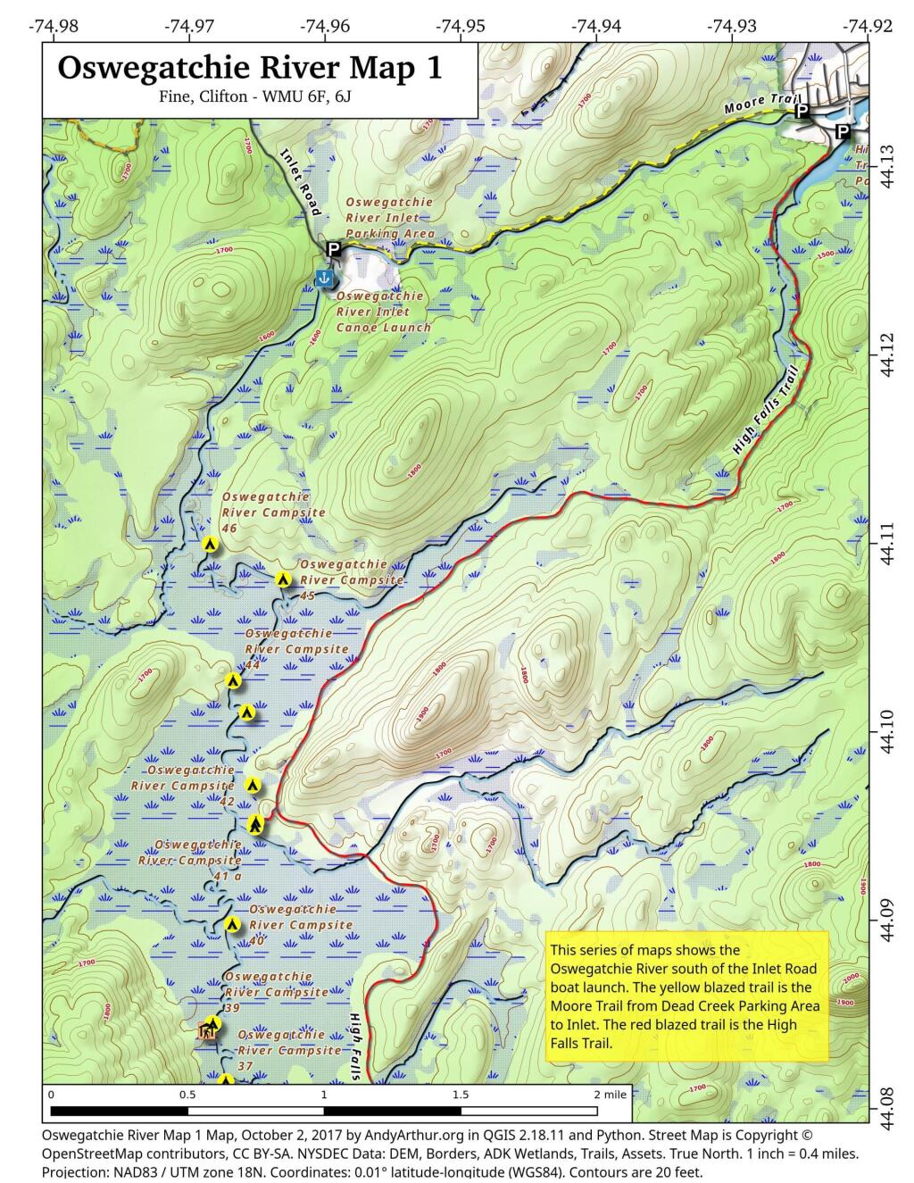
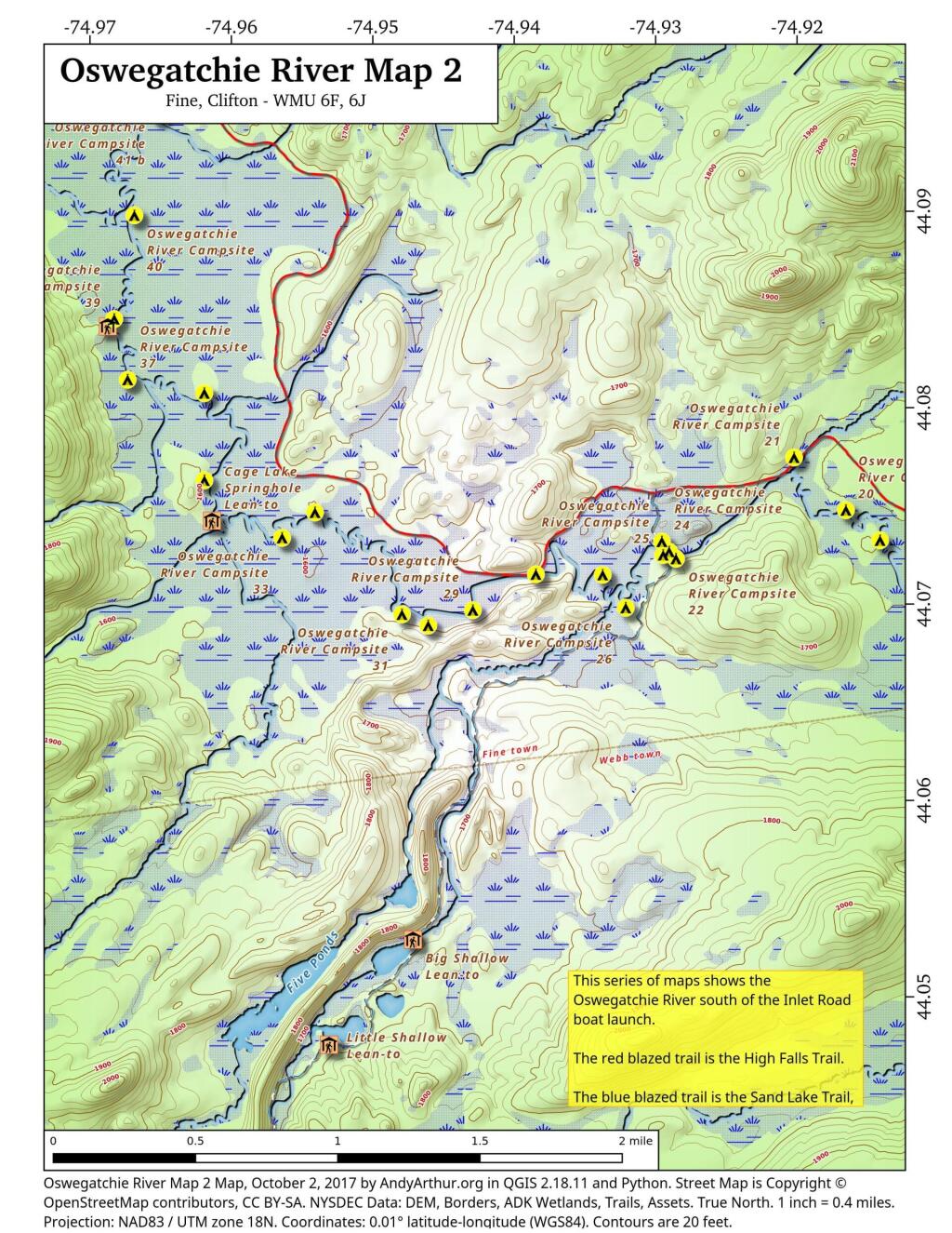
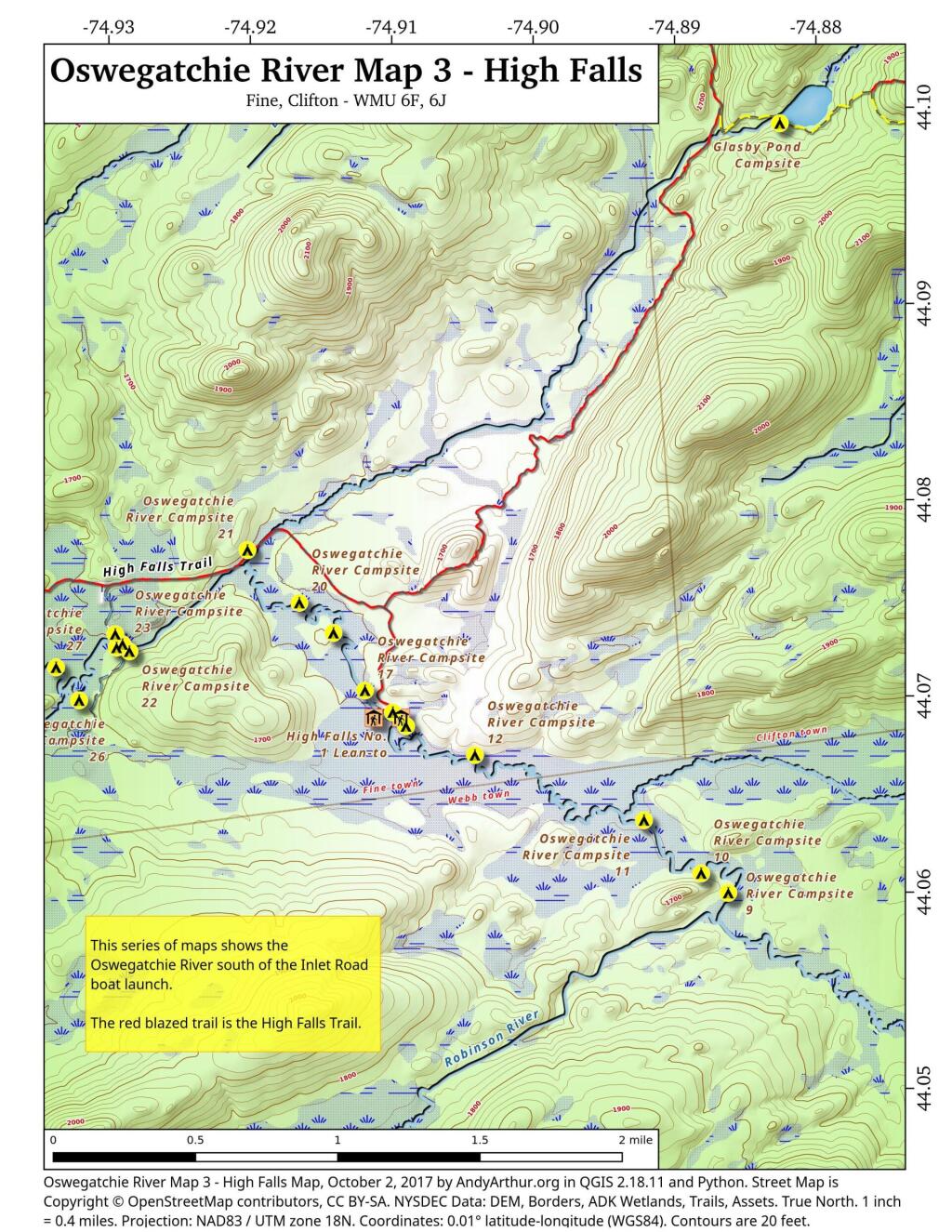
Printable Maps of Oswegatchie River Campsites and Lean-Tos

 Oswegatchie River Map 1

 Oswegatchie River Map 2

 Oswegatchie River Map 3 - High Falls

List of Oswegatchie River Campsites and Lean-Tos

Here is a list of Oswegatchie River Campsites and Lean-Tos with coordinates. They are sorted north to south. You can also get this as a Google Sheet for ease of downloading into your GPS.

NameDetailsLocation
Oswegatchie River Inlet Parking AreaGravel parking area44.12443118931201,-74.96021183665184
Oswegatchie River Inlet Canoe LaunchHand carry launch. Oswegatchie river44.12409861000839,-74.96006625629072
Oswegatchie River Campsite 46Designated campsite. No outhouse.44.1099997656786,-74.96849666115645
Oswegatchie River Campsite 45Designated campsite. No outhouse. Large White Pine overstory.44.1081261918206,-74.9631088853723
Oswegatchie River Campsite 44Designated campsite. No outhouse. White Pine overstory.44.10274849797629,-74.96679915443202
Oswegatchie River Campsite 43Designated campsite. No outhouse. Nice site under White Pine and hemlock.44.101065191632905,-74.96577985008783
Oswegatchie River Campsite 42Designated campsite. No outhouse.44.09720754685212,-74.96536327814668
Oswegatchie River Campsite 41 BDesignated campsite. Shares full sized outhouse with 41 a.44.0952454709372,-74.96512556000707
Oswegatchie River Campsite 41 ADesignated campsite. Shares full sized outhouse with 41 b.44.09498215224536,-74.96519748460433
Oswegatchie River Campsite 40Designated campsite. No outhouse.44.08981881642045,-74.96686858363239
Oswegatchie River Campsite 39Designated campsite. Shares full sized outhouse with lean-to.44.0845390569362,-74.96829359032023
Griffin Rapids Lean-ToOswegatchie river campsite 38. With full sized outhouse.44.08416539190812,-74.96874797335943
Oswegatchie River Campsite 37Designated campsite. No outhouse.44.081449235808094,-74.96734861635957
Oswegatchie River Campsite 36Appears to be rarely used. Re-signed at campsite, 05/2016.44.08076066223312,-74.96192854447926
Oswegatchie River Campsite 21With full sized outhouse. outhouse needs to be replaced.44.0774668251364,-74.92023479225502
Oswegatchie River Campsite 35Poor campsite on narrow bank along river. No outhouse.44.07631976413254,-74.96192259334101
Oswegatchie River Campsite 20Designated campsite. No outhouse.44.07477874950931,-74.91657391326872
Oswegatchie River Campsite 32Designated site. No outhouse.44.07468487279131,-74.95410705888409
Cage Lake Springhole Lean-ToOswegatchie River Campsite 34 and Buck Brook lean-to. With full sized outhouse.44.07426192277586,-74.96138724158183
Oswegatchie River Campsite 33Designated campsite. No outhouse.44.073391797670325,-74.95643228093942
Oswegatchie River Campsite 19Designated campsite. No outhouse.44.07324092124128,-74.9141633627036
Oswegatchie River Campsite 24Campsite on knob just north of foot bridge.44.073192307051784,-74.92958639526513
Oswegatchie River Campsite 23No obvious outhouse.44.07267707183023,-74.92907367419755
Oswegatchie River Campsite 25Designated campsite. No obvious outhouse44.07250675167277,-74.92949519999124
Oswegatchie River Campsite 22No obvious outhouse.44.07231405159984,-74.92858911655944
Oswegatchie River Campsite 28No obvious outhouse. On narrow strip of land between river and hiking trail.44.07152841600008,-74.9384951811928
Oswegatchie River Campsite 27Designated site. No outhouse.44.071498659692026,-74.93377315442581
Oswegatchie River Campsite 17No obvious outhouse.44.07030826156362,-74.9119367954832
Oswegatchie River Campsite 26Designated site. No outhouse. Former site of guide art leary’s camp.44.06982014142839,-74.93214452928088
Oswegatchie River Campsite 29Designated campsite. No outhouse.44.069703084074106,-74.94295216734594
Oswegatchie River Campsite 31Designated site. No outhouse.44.06949136260463,-74.94796488517912
Oswegatchie River Campsite 16With full sized outhouse.44.06919421410159,-74.90997016838134
Oswegatchie River Campsite 30Designated campsite. No outhouse.44.06892407580466,-74.94610904969508
High Falls No. 2 Lean-ToAlso here, Oswegatchie river campsite 13. With full sized outhouse.44.06891348697742,-74.9113129664397
High Falls No. 1 Lean-ToAlso here, Oswegatchie river campsite 15. With full sized outhouse.44.06890982511321,-74.90939691179359
Oswegatchie River Campsite 14Shares outhouse with lean-to.44.06848762867845,-74.90903933983748
Oswegatchie River Campsite 12Designated campsite. No outhouse.44.06701056940781,-74.90417255789619
Oswegatchie River Campsite 10Designated campsite. No outhouse.44.06096855932064,-74.88818835643873
Oswegatchie River Campsite 9Designated campsite. No outhouse.44.05997161595347,-74.88627678133585
Oswegatchie River Campsite 8Designated campsite. No outhouse.44.05339349849945,-74.8716957113609
Oswegatchie River Campsite 6Designated site. No outhouse.44.04936909651902,-74.86294215811668
Oswegatchie River Campsite 5Designated campsite. No outhouse.44.048445662452906,-74.86176785303444
Oswegatchie River Campsite 4 44.04369429633436,-74.85751646996977
Oswegatchie Canoe Carry Hand LaunchHand carry launch, canoe launch44.04330626616994,-74.85744713528497

Largest Municipalities in Each County

Most of the largest cities and towns in each county is well known, and in many cases it is the county seat. Starred towns in Italic are county seats.

County – Largest Municipality Population
Albany County – Albany city* 97,279
Allegany County – Wellsville town 6,974
Broome County – Union town 53,251
Cattaraugus County – Olean city 13,597
Cayuga County – Auburn city* 26,454
Chautauqua County – Jamestown city 29,315
Chenango County – Norwich city* 6644
Chemung County – Elmira city* 27,204
Clinton County – Plattsburgh city* 19,438
Columbia County – Kinderhook town 8,215
Cortland County – Cortland city* 18,713
Delaware County – Sidney town 5,367
Dutchess County – Poughkeepsie town 44,035
Erie County – Buffalo city* 256,304
Essex County – North Elba town 8,094
Franklin County – Malone town* 14,139
Fulton County – Gloversville city 14,832
Genesee County – Batavia city* 14,491
Greene County – Catskill town* 11,364
Hamilton County – Indian Lake town 1,245
Herkimer County – German Flatts town 12,547
Jefferson County – Watertown city 25,290
Lewis County – Lowville town* 4,840
Livingston County – Geneseo town* 10,691
Madison County – Sullivan town 15,149
Monroe County – Rochester city* 206,284
Montgomery County – Amsterdam city 17,864
Nassau County – Hempstead town 768,103
Niagara County – Niagara Falls city* 48,144
Oneida County – Utica city* 60,100
Onondaga County – Syracuse city* 142,749
Ontario County – Victor town 15,069
Orange County – Warwick town 31,185
Orleans County – Albion town* 8,138
Oswego County – Oswego city* 17,337
Otsego County – Oneonta city 13,918
Putnam County – Carmel town* 34,245
Rensselaer County – Troy city* 49,374
Rockland County – Ramapo town 136,848
Saratoga County – Clifton Park town 36,566
Schenectady County – Schenectady city* 65,575
Schoharie County – Cobleskill town 6,239
Schuyler County – Hector town 4,933
Seneca County – Seneca Falls town 8,680
St. Lawrence County – Potsdam town 15,322
Steuben County – Bath town 11,938
Suffolk County – Brookhaven town 482,436
Sullivan County – Thompson town 15,019
Tioga County – Owego town* 18,843
Tompkins County – Ithaca city* 30,999
Ulster County – Kingston city* 22,950
Warren County – Queensbury town* 27,471
Washington County – Kingsbury town 12,346
Wayne County – Arcadia town 13,564
Westchester County – Yonkers city 199,663
Wyoming County – Attica town 7,021
Yates County – Milo town 6,811

Shots – Health News : NPR

Tiny houses are cropping up around the country to give shelter to the homeless : Shots – Health News : NPR

Tucked inside a residential neighborhood in Madison, Wis., and surrounded by a wooden fence and greenery, are nine little houses. With multicolored siding and roofs, they look like people-sized birdhouses. And they fit right in.

So does Gene Cox, 48. He hasn't been homeless in more than seven years. That's the point of this little development.

"This is the longest time I've stayed in one place," said Cox, nursing coffee and a cigarette outside his tiny home after working second shift as a benefits administrator. "I'm very nomadic. I've moved around Wisconsin a lot over the last 22 years."

I can only imagine how controversial a proposal to adopt a digital currency would be

I can only imagine how controversial a proposal to adopt a digital currency would be. πŸ’΅

If the government has access to your digital currency, it could lead to all kinds of privacy violations and abuses.

At least with a credit card, your financial data is in the hands of a private business, so you have some certainty that the government will need to get a search warrant before rummaging through your list of purchases. While certainly some privacy safe guards can be set up with a digital currency, you got to think that there is still some greater protections by having your money in a private institution then in the hands of the government.