One stop shop for Exchange, Transform, Load – best reason for making maps with R 🗺
While the R programming may not be considered a GIS map making program, it does one thing exceptionally well – exchange, transform and load data onto map. It really is a one stop shop. A few lines of code handles it all, and the code can be reused from map to map.
Traditionally before I got into R, I would manually download data, clean it in LibreOffice Calc aka Excel then link it in QGIS to a shapefile. That’s a lot of clicking and repetitive work that can easily be automated and repeated in R Studio, and run over and over again. Often in a fraction of the time, sometimes even less if I’m just updating the map with the latest days data or just making minor transformation of the data.
But with R it’s one stop shopping. You can often the load the data directly into R by either using read_csv on an internet dataset like from data.ny.gov, then process it in the same pipeline using mutate or summarize, join the data using inner_join, then plot it directly on the map using ggplot. No flipping through windows, mingling datatypes manually, clicking through join options or style options in QGIS. The default palettes and options in ggplot are often attractive, and needing only minor adjustment in codes.
And generally I’m happy with the output of ggplot for map making. Usually the output is consistent and easy to read, although sometimes things like title strings get chopped off and I need to adjust the parameters. But it’s just code and usually just requires me to change a line or two of the code before proceeding. The output is SVG, and often very good quality, with files small and easy to compress as compressed SVG for sharing on the blog.
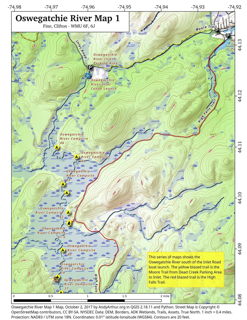
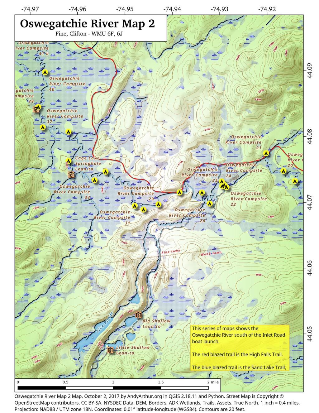
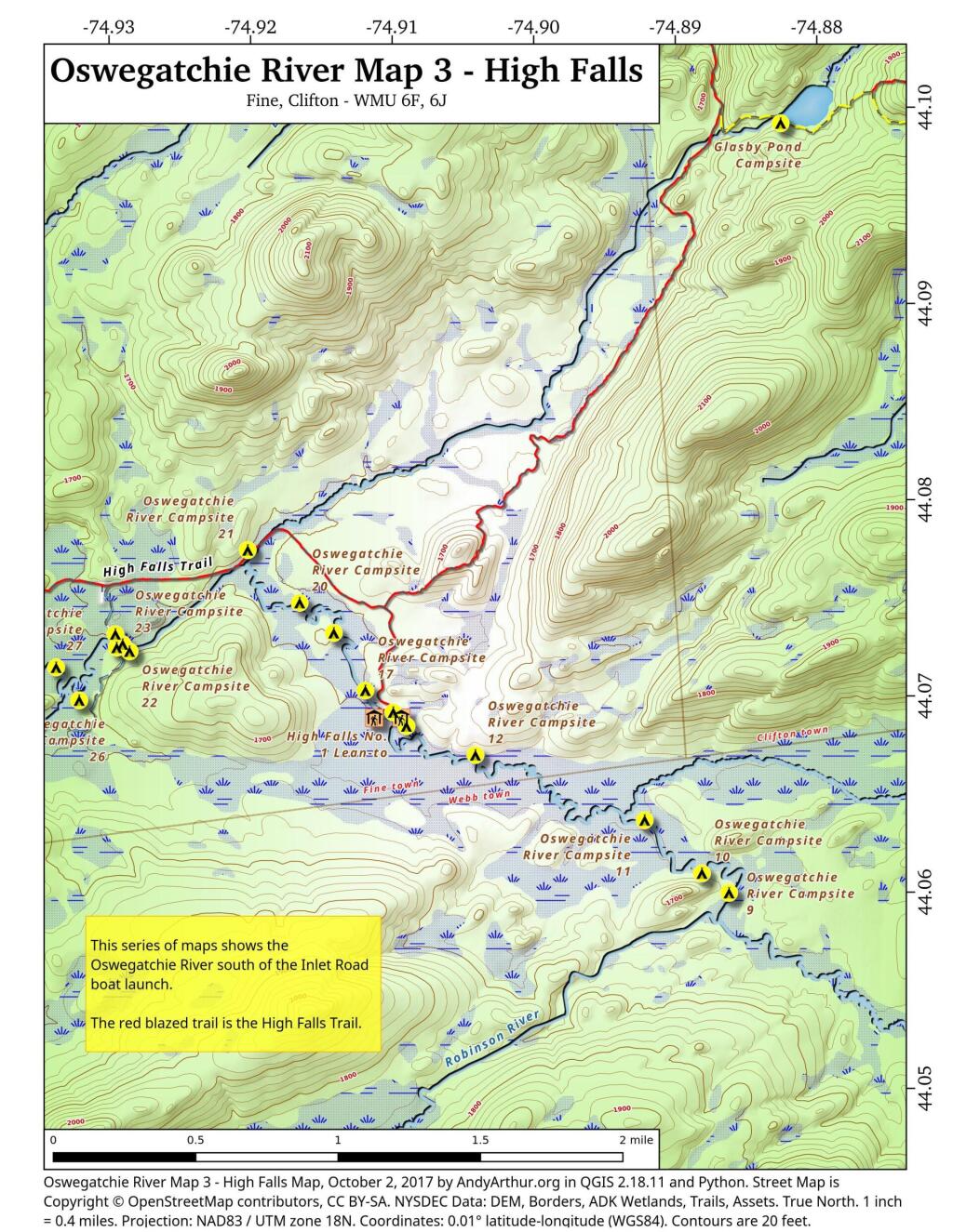
Printable Maps of Oswegatchie River Campsites and Lean-Tos
List of Oswegatchie River Campsites and Lean-Tos
Here is a list of Oswegatchie River Campsites and Lean-Tos with coordinates. They are sorted north to south. You can also get this as a Google Sheet for ease of downloading into your GPS.
Name
Details
Location
Oswegatchie River Inlet Parking Area
Gravel parking area
44.12443118931201,-74.96021183665184
Oswegatchie River Inlet Canoe Launch
Hand carry launch. Oswegatchie river
44.12409861000839,-74.96006625629072
Oswegatchie River Campsite 46
Designated campsite. No outhouse.
44.1099997656786,-74.96849666115645
Oswegatchie River Campsite 45
Designated campsite. No outhouse. Large White Pine overstory.
44.1081261918206,-74.9631088853723
Oswegatchie River Campsite 44
Designated campsite. No outhouse. White Pine overstory.
44.10274849797629,-74.96679915443202
Oswegatchie River Campsite 43
Designated campsite. No outhouse. Nice site under White Pine and hemlock.
44.101065191632905,-74.96577985008783
Oswegatchie River Campsite 42
Designated campsite. No outhouse.
44.09720754685212,-74.96536327814668
Oswegatchie River Campsite 41 B
Designated campsite. Shares full sized outhouse with 41 a.
44.0952454709372,-74.96512556000707
Oswegatchie River Campsite 41 A
Designated campsite. Shares full sized outhouse with 41 b.
44.09498215224536,-74.96519748460433
Oswegatchie River Campsite 40
Designated campsite. No outhouse.
44.08981881642045,-74.96686858363239
Oswegatchie River Campsite 39
Designated campsite. Shares full sized outhouse with lean-to.
44.0845390569362,-74.96829359032023
Griffin Rapids Lean-To
Oswegatchie river campsite 38. With full sized outhouse.
44.08416539190812,-74.96874797335943
Oswegatchie River Campsite 37
Designated campsite. No outhouse.
44.081449235808094,-74.96734861635957
Oswegatchie River Campsite 36
Appears to be rarely used. Re-signed at campsite, 05/2016.
44.08076066223312,-74.96192854447926
Oswegatchie River Campsite 21
With full sized outhouse. outhouse needs to be replaced.
44.0774668251364,-74.92023479225502
Oswegatchie River Campsite 35
Poor campsite on narrow bank along river. No outhouse.
44.07631976413254,-74.96192259334101
Oswegatchie River Campsite 20
Designated campsite. No outhouse.
44.07477874950931,-74.91657391326872
Oswegatchie River Campsite 32
Designated site. No outhouse.
44.07468487279131,-74.95410705888409
Cage Lake Springhole Lean-To
Oswegatchie River Campsite 34 and Buck Brook lean-to. With full sized outhouse.
44.07426192277586,-74.96138724158183
Oswegatchie River Campsite 33
Designated campsite. No outhouse.
44.073391797670325,-74.95643228093942
Oswegatchie River Campsite 19
Designated campsite. No outhouse.
44.07324092124128,-74.9141633627036
Oswegatchie River Campsite 24
Campsite on knob just north of foot bridge.
44.073192307051784,-74.92958639526513
Oswegatchie River Campsite 23
No obvious outhouse.
44.07267707183023,-74.92907367419755
Oswegatchie River Campsite 25
Designated campsite. No obvious outhouse
44.07250675167277,-74.92949519999124
Oswegatchie River Campsite 22
No obvious outhouse.
44.07231405159984,-74.92858911655944
Oswegatchie River Campsite 28
No obvious outhouse. On narrow strip of land between river and hiking trail.
44.07152841600008,-74.9384951811928
Oswegatchie River Campsite 27
Designated site. No outhouse.
44.071498659692026,-74.93377315442581
Oswegatchie River Campsite 17
No obvious outhouse.
44.07030826156362,-74.9119367954832
Oswegatchie River Campsite 26
Designated site. No outhouse. Former site of guide art leary’s camp.
44.06982014142839,-74.93214452928088
Oswegatchie River Campsite 29
Designated campsite. No outhouse.
44.069703084074106,-74.94295216734594
Oswegatchie River Campsite 31
Designated site. No outhouse.
44.06949136260463,-74.94796488517912
Oswegatchie River Campsite 16
With full sized outhouse.
44.06919421410159,-74.90997016838134
Oswegatchie River Campsite 30
Designated campsite. No outhouse.
44.06892407580466,-74.94610904969508
High Falls No. 2 Lean-To
Also here, Oswegatchie river campsite 13. With full sized outhouse.
44.06891348697742,-74.9113129664397
High Falls No. 1 Lean-To
Also here, Oswegatchie river campsite 15. With full sized outhouse.
Tucked inside a residential neighborhood in Madison, Wis., and surrounded by a wooden fence and greenery, are nine little houses. With multicolored siding and roofs, they look like people-sized birdhouses. And they fit right in.
So does Gene Cox, 48. He hasn't been homeless in more than seven years. That's the point of this little development.
"This is the longest time I've stayed in one place," said Cox, nursing coffee and a cigarette outside his tiny home after working second shift as a benefits administrator. "I'm very nomadic. I've moved around Wisconsin a lot over the last 22 years."
At least with a credit card, your financial data is in the hands of a private business, so you have some certainty that the government will need to get a search warrant before rummaging through your list of purchases. While certainly some privacy safe guards can be set up with a digital currency, you got to think that there is still some greater protections by having your money in a private institution then in the hands of the government.
The U.S. is gingerly considering whether to adopt a digital version of its currency, one better suited for today's increasingly cashless world, ushering in what could be one of the dollar's most fundamental transformations.
In that scenario, the U.S. would not only mint the coins and print paper bills. It would also issue digital cash, or a central bank digital currency (CBDC), that would be stored in apps or "digital wallets" on our smartphones.