The Rattlesnake Hill Wildlife Management Area is a 5,100 acre upland tract, situated approximately eight miles west of Dansville, New York. Roughly two-thirds of the area lies in southern Livingston County, while the remaining third lies in northern Allegany County. The tract was purchased in the 1930’s under the Federal Resettlement Administration and is one of several such areas turned over to DEC for development as a wildlife management area.
The area is appropriately named after the Timber Rattlesnake, which may be occasionally found in the more remote sections of the “Hill”.
The area offers an interesting blend of upland habitats such as mature woodland, overgrown fields, conifer plantations, old growth apple orchards and open meadows.
The area is inhabited by a variety of game species and is open to public hunting. The white-tailed deer, wild turkey, ruffed grouse, grey squirrel, cottontail rabbit and woodcock are found on the area. An occasional snowshoe hare may be observed adjacent to thick creek bottom brush or conifer plantation habitats.
A number of small marsh units have been developed and provide limited hunting for waterfowl. Some of the area’s furbearing species such as mink, beaver and raccoon may be occasionally viewed at these marsh units.
I think a lot about eventually settling in a place like Missouri that is cheap with taxes low, few government regulations out in the country, less harsh winters but lots of public lands, forests and natural resources to explore. I’ve always been fascinated by that state and people’s love of the land and conservation out there – from the farmers and grazers to the hunters and trappers.
Missouri seems to be a mecha for outdoorsman and homesteaders off griders and those who just be left alone and not have neighbors nearby or pay a lot of taxes on your land. For people who will never apologize for being country boys or having a love of the land.
I don’t like the idea of riding an air plane or renting a car. But I probably could camp there as an alternative to motels. I would really want to see what the back country is like, the dirt roads, the mountains, and the rough, raggy run down farms and homesteads rather than any city or tourist destination. Sure I might stop at a famous vista or park but I can’t imagine spending more than five minutes in any populated area except to get gas or groceries. I like being in the rough country and I wouldn’t go to Missouri to see anything touristy but to see if it’s all its cracked up to be on the YouTube.
One of my formally favorite writers, James Howard Kunstler has just gotten weirder and weirder in recent years since the end of the Trump presidency and COVID-19. I used to enjoy his tough analysis of things like suburban sprawl, our tacky inorganic, motoring is everything communities.
He made some good points about peak oil, although once the fracking boom left the world flush with oil he had to search for excuses to explain why oil became so cheap at least temporarily. But since the rise of Donald Trump, he’s gotten all weird, embracing a series of right wing cranks on his blog and podcast show. I can’t imagine a peace or sustainability group inviting him to talk today, compared to even a decade ago when he was a hot commodity.
People change over time, the grow and learn new things. Kunstler ain’t the guy I knew 25 years ago but neither am I. He made his decision on what to focus on but it seems like most of the claims of election fraud or COVID conspiracy is just the world of cranks not a serious or legitimate criticism of problems we all face today.
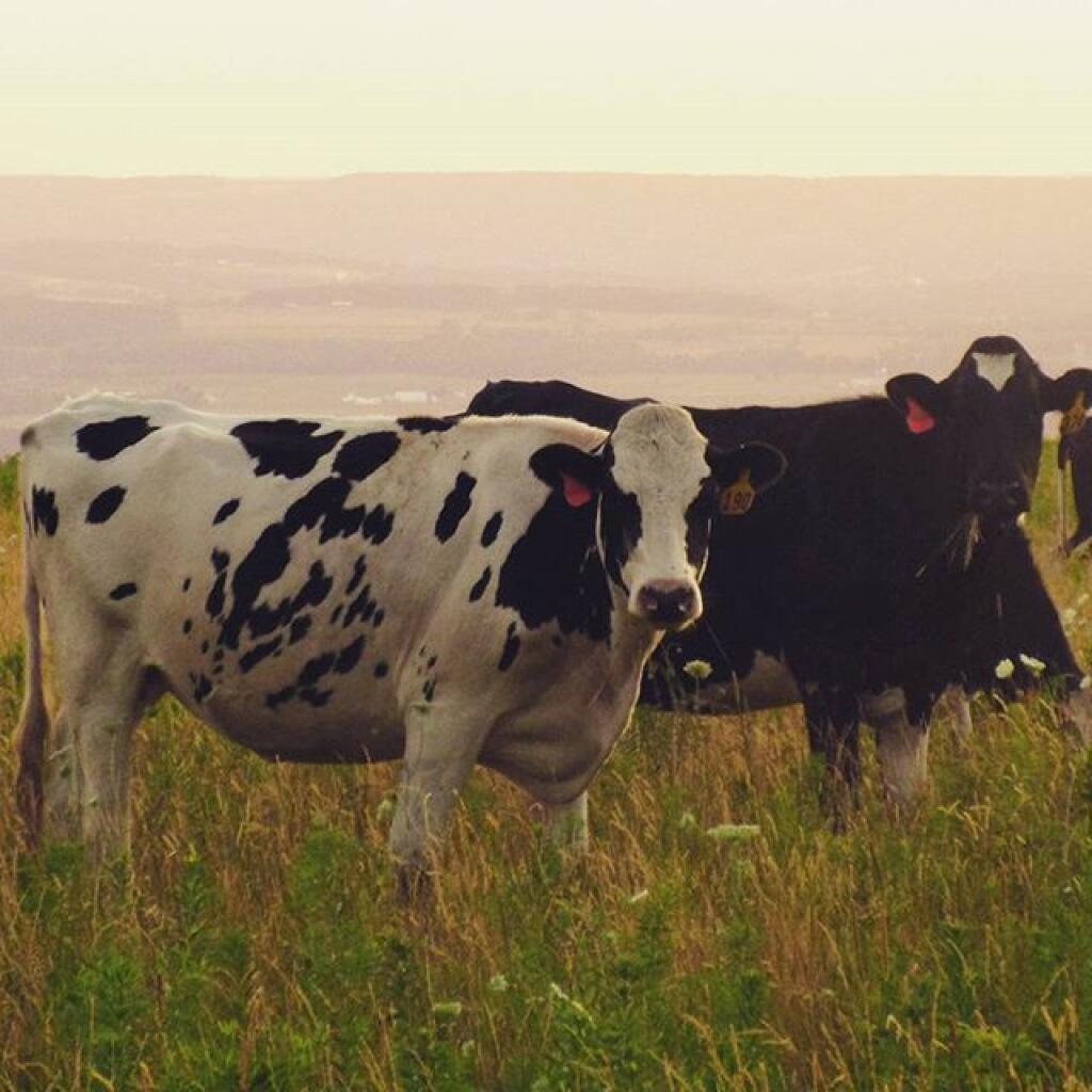
I’ve been re-reading Storey’s Guide to Raising Beef Cattle, the book by Heather Smith that is famous for teaching people the basics of the cattle industry.
They say roughly one million households raise cattle in America, it’s hard to go to small town outside of the most rugged mountain country and not see cattle or their distinctive barnyard smell.
Cattle grow in nearly every rural part of America, they need little more than grass or hay, water and salt and some careful care and supervision of their pastures and hay and shelter during the winter months.
Some of the oldest, long rooted families in our country farm, beef and dairy and the crops that support them fill our valleys. One out of four acres are field crops in New York, a number only second to the vast forests that cover our mountains and hill tops.
Cows are living, breathing animals, they can have a wide variety of health problems and conditions. They require a lot of feed and water but fortunately they’re not particularly picky about grass, as long as it’s free of manure and a handful of noxious weeds. They can break down grasses to produce energy to feed their growth.
Cattle have a larger than life impacts on the land and have a defining impact on communities and their identity. It’s always interesting to understand more about the lives of these large animals.
Reactance in electricity is like free returns to stores. Yes, some electricity returned to grid with current and voltage out of phase is resold to other customers but a lot of it is just wasted.
Cultivated Crops -areas used for the production of annual crops, such as corn, soybeans, vegetables, tobacco, and cotton, and also perennial woody crops such as orchards and vineyards. Crop vegetation accounts for greater than 20% of total vegetation. This class also includes all land being actively tilled.
3
0.0%
52
Shrub/Scrub- areas dominated by shrubs; less than 5 meters tall with shrub canopy typically greater than 20% of total vegetation. This class includes true shrubs, young trees in an early successional stage or trees stunted from environmental conditions.
14
0.1%
95
Emergent Herbaceous Wetlands- Areas where perennial herbaceous vegetation accounts for greater than 80% of vegetative cover and the soil or substrate is periodically saturated with or covered with water.
26
0.2%
31
Barren Land (Rock/Sand/Clay) – areas of bedrock, desert pavement, scarps, talus, slides, volcanic material, glacial debris, sand dunes, strip mines, gravel pits and other accumulations of earthen material. Generally, vegetation accounts for less than 15% of total cover.
110
0.8%
90
Woody Wetlands- areas where forest or shrubland vegetation accounts for greater than 20% of vegetative cover and the soil or substrate is periodically saturated with or covered with water.
158
1.1%
42
Evergreen Forest- areas dominated by trees generally greater than 5 meters tall, and greater than 20% of total vegetation cover. More than 75% of the tree species maintain their leaves all year. Canopy is never without green foliage.
215
1.5%
71
Sedge/Herbaceous- Alaska only areas dominated by sedges and forbs, generally greater than 80% of total vegetation. This type can occur with significant other grasses or other grass like plants, and includes sedge tundra, and sedge tussock tundra.
267
1.9%
11
Open Water- areas of open water, generally with less than 25% cover of vegetation or soil.
270
1.9%
81
Pasture/Hay-areas of grasses, legumes, or grass-legume mixtures planted for livestock grazing or the production of seed or hay crops, typically on a perennial cycle. Pasture/hay vegetation accounts for greater than 20% of total vegetation.
344
2.5%
41
Deciduous Forest- areas dominated by trees generally greater than 5 meters tall, and greater than 20% of total vegetation cover. More than 75% of the tree species shed foliage simultaneously in response to seasonal change.
628
4.5%
43
Mixed Forest- areas dominated by trees generally greater than 5 meters tall, and greater than 20% of total vegetation cover. Neither deciduous nor evergreen species are greater than 75% of total tree cover.
1,031
7.3%
24
Developed High Intensity-highly developed areas where people reside or work in high numbers. Examples include apartment complexes, row houses and commercial/industrial. Impervious surfaces account for 80% to 100% of the total cover.
2,093
14.9%
21
Developed, Open Space- areas with a mixture of some constructed materials, but mostly vegetation in the form of lawn grasses. Impervious surfaces account for less than 20% of total cover. These areas most commonly include large-lot single-family housing units, parks, golf courses, and vegetation planted in developed settings for recreation, erosion control, or aesthetic purposes.
2,206
15.7%
22
Developed, Low Intensity- areas with a mixture of constructed materials and vegetation. Impervious surfaces account for 20% to 49% percent of total cover. These areas most commonly include single-family housing units.
3,148
22.4%
23
Developed, Medium Intensity -areas with a mixture of constructed materials and vegetation. Impervious surfaces account for 50% to 79% of the total cover. These areas most commonly include single-family housing units.
I think it’s absurd to keep closing our eyes about climate change. It’s here already, and it’s going to get a lot worse. Flooding and air pollution are big concerns locally, the fires and droughts are the story out west. It doesn’t help that people are pretending that we can slap a few solar panels up, and buy greenie products, and say the problem is fixed.
It’s not fixed and it’s not likely to be fixed. And it’s going to be real bad, regardless of what we do.
One of the ways I’ve been playing with the state tax records database is to experiment with the property tax database to figure out how old various streets are. While certainly people can and do build and rebuild houses on roads well after a street is constructed, looking at the median age of buildings on a street can give you a ballpark estimate on how old a street is and how old the particular neighborhood is. Probably the next step would be to plot this on a map.
Clearly with the median building dates, you can find the newest streets and developments in Altamont — and which neighborhoods and streets are rich in history.