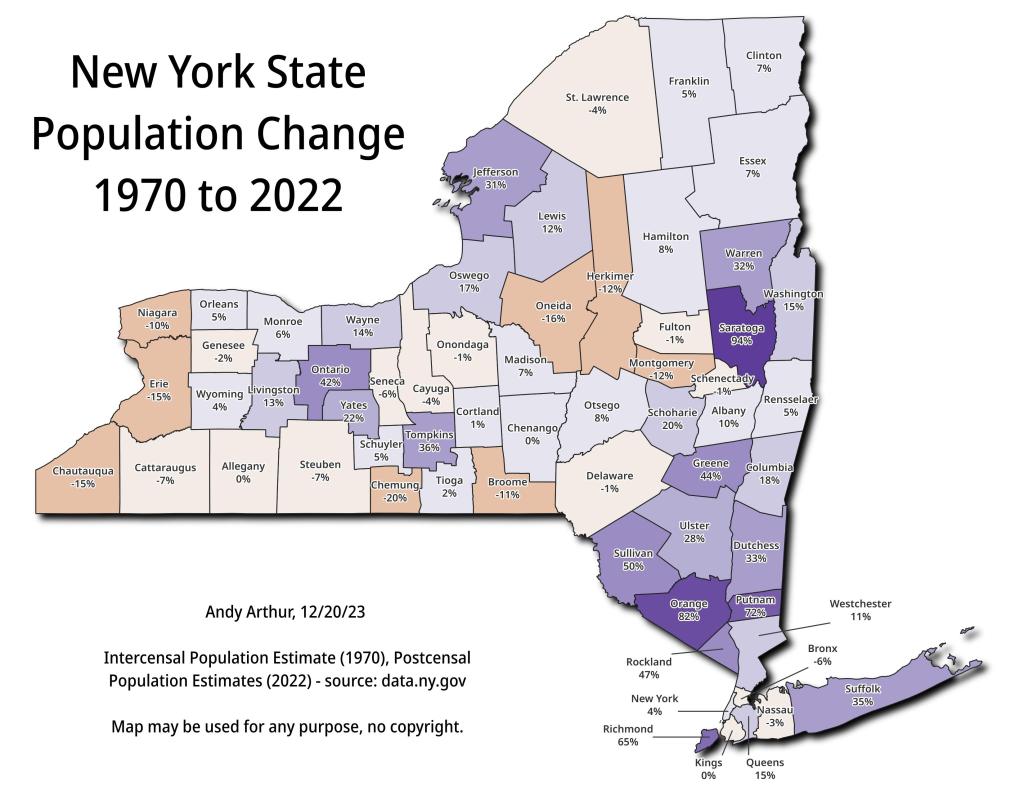
NY Population Change 1970 to 2022 🗺️ Download a High Resolution JPEG Image of the NY Population Change 1970 to 2022 or an Adobe Acrobat Printable PDF of the Thematic NY Population Change 1970 to 2022. More about US Census...Maps that look at the US Census at the macro-perspective of all counties in the United States. Maps and Interactivesus-state-pop-density-1900US Population Non Contiguous CartogramUS Population DensityUS Population Change – 2020 to 2024US Median Household Income by Census TractUntitledNY Population Change 1970 to 2022Metro Areas in New YorkHouseholds Making Less then $50,000 in Each StateHouseholds Making Less then $100,000/yr in 2023Each dot represents a census block with 100 New YorkersCounty Population Under 25kCensus Tracts in America with Fewer then 100 People Per Square MileBOCES DistrictsAlbany Population Density2020 County Population Dot Density... photos, maps and other content from from US Census. Leave a Reply Cancel replyYour email address will not be published. Required fields are marked *Comment * Name * Email * Website Save my name, email, and website in this browser for the next time I comment. Δ
More about US Census...Maps that look at the US Census at the macro-perspective of all counties in the United States. Maps and Interactivesus-state-pop-density-1900US Population Non Contiguous CartogramUS Population DensityUS Population Change – 2020 to 2024US Median Household Income by Census TractUntitledNY Population Change 1970 to 2022Metro Areas in New YorkHouseholds Making Less then $50,000 in Each StateHouseholds Making Less then $100,000/yr in 2023Each dot represents a census block with 100 New YorkersCounty Population Under 25kCensus Tracts in America with Fewer then 100 People Per Square MileBOCES DistrictsAlbany Population Density2020 County Population Dot Density... photos, maps and other content from from US Census.
Leave a Reply Cancel replyYour email address will not be published. Required fields are marked *Comment * Name * Email * Website Save my name, email, and website in this browser for the next time I comment. Δ
