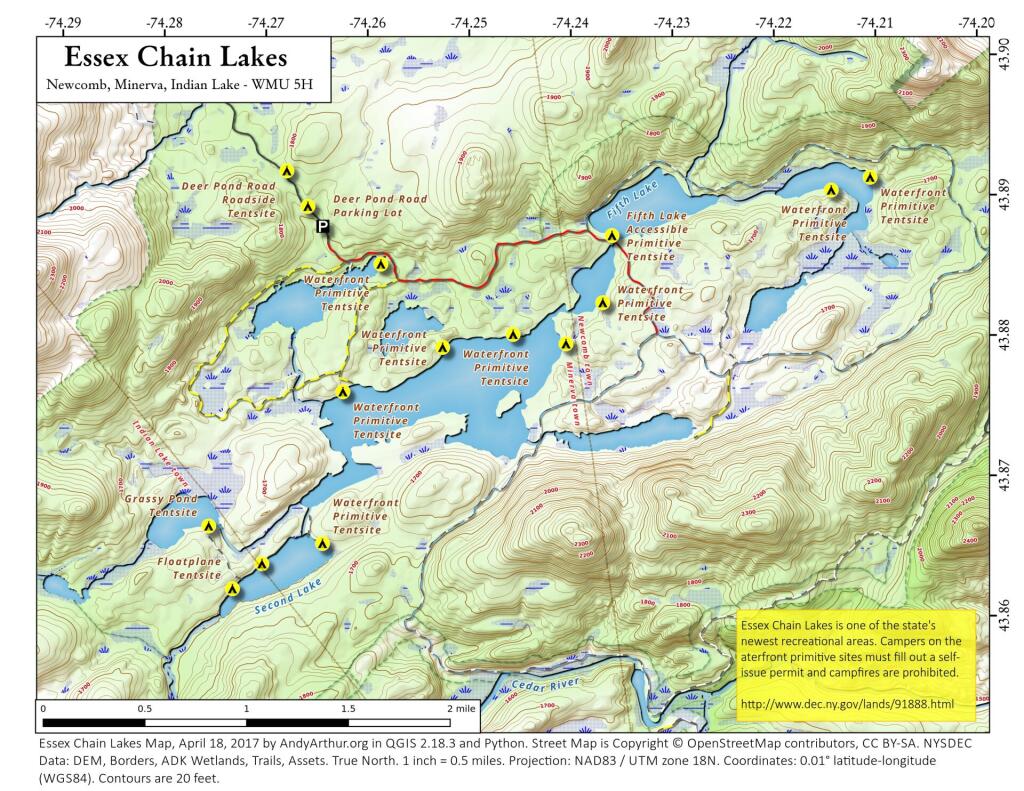
Essex Chain of Lakes – Coordinates and Maps 🏕 Essex Chain of Lakes – Coordinates and Maps 🏕 Interactive Map Download the KML file for use in Google Maps or GPS apps. Printable Maps of Oswegatchie River Campsites and Lean-Tos List of Essex Chain of Lakes Campsites Here is a list of Essex Chain Lake Campsites. Special restrictions and reservation exist for many of these campsites, see the DEC website for details. You can also get this as a Google Sheet for ease of downloading into your GPS. Name Descrip Latitude Longitude Camp Six Rd Seasonal (Fall) Parking Area 2-3 spaces 43.8781945875647 -74.1951257407619 Camp Six Road Roadside Tentsite 43.891098208087 -74.1858223467572 Camp Six Road Roadside Tentsite 43.880775618509 -74.1920319664505 Camp Six Road Roadside Tentsite 43.8867689717605 -74.1881150206844 Cedar/Hudson River Campsite 43.8526463367848 -74.188226184425 Chain Lakes Rd South Seasonal (Fall) Parking Area 43.8398670879606 -74.2193187297406 Chain Lakes Road South Parking Lot 43.8169730010758 -74.206490005958 Chain Lakes Road South Roadside Tentsite 43.8354885828321 -74.2095424278515 Chain Lakes Road South Roadside Tentsite 43.8318737372315 -74.2087246610165 Chain Lakes Road South Roadside Tentsite 43.8284300483248 -74.2005840726962 Cornell Road Roadside Tentsite 43.9127605502315 -74.2589305446633 Cornell Road Roadside Tentsite 43.90792941637 -74.2708080639985 Cornell Road Roadside Tentsite 43.9067653589248 -74.2728139422411 Cornell Road Roadside Tentsite 43.9119638675587 -74.2629609782825 Deer Pond Road Parking Lot 43.8881877909056 -74.26459017266 Deer Pond Road Roadside Tentsite 43.8921619513765 -74.2680906874901 Deer Pond Road Roadside Tentsite 43.8896153020103 -74.2660494488172 Essex Chain Equestrian Staging Area Includes accessible mounting platform & kiosk 43.9080902992726 -74.1856206534589 Floatplane Tentsite 43.8624107973145 -74.2738175850679 Floatplane Tentsite 43.8441807728989 -74.2572948564662 Floatplane Tentsite 43.8641746165881 -74.2708879596156 Grassy Pond Tentsite 43.8668988556171 -74.2761009397051 Indian River Put-In Parking Lot 43.8016889699131 -74.2299529872379 Indian River Put-In Water Access Hand-carry launch 43.8017043411256 -74.228261437504 Outer Gooley Parking Area 43.8273906506622 -74.2007441162829 Parking Area 43.9144824495811 -74.1846526844935 Pine Lake Primtive Tentsite 43.8493835353493 -74.2458702713384 Polaris (Iron) Bridge Tentsite 43.8946526943318 -74.1651586934731 Polaris Bridge Parking Area 2-3 spaces 43.8954955101626 -74.1682746441243 Waterfront Primitive Tentsite 43.8803564638727 -74.245948680651 Waterfront Primitive Tentsite 43.8794781290843 -74.2529060663751 Waterfront Primitive Tentsite 43.8825615413222 -74.2370898191954 Waterfront Primitive Tentsite 43.8854551161564 -74.2589146456769 Waterfront Primitive Tentsite 43.8763773474625 -74.2627649431543 Waterfront Primitive Tentsite 43.8913218971427 -74.2106406874051 Waterfront Primitive Tentsite 43.865579967021 -74.2649096009151 Waterfront Primitive Tentsite 43.8796521294405 -74.2407518111291 Waterfront Primitive Tentsite 43.8904359124813 -74.2144855367511
2 Comments Alec Muller says: July 31, 2025 at 3:25 pm Is there a parking lot and/or boat launch for canoes at the polaris bridge? Reply Andy says: August 4, 2025 at 1:11 pm Not sure Reply Leave a Reply Cancel replyYour email address will not be published. Required fields are marked *Comment * Name * Email * Website Save my name, email, and website in this browser for the next time I comment. Δ
2 Comments
Is there a parking lot and/or boat launch for canoes at the polaris bridge?
Not sure