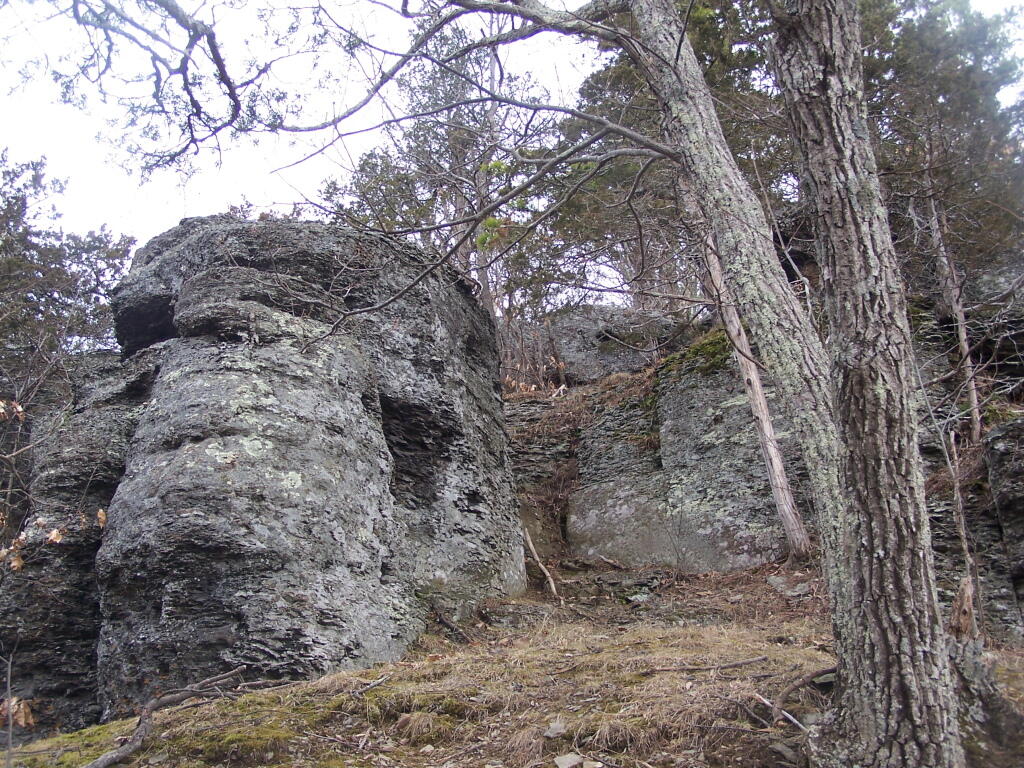
Cliff of Middleberg
Now this isn't necessarily something you'd write to folks back home about, but once on top, there are some rather cool views.
Sunday March 21, 2010 — Middleburgh Cliff
Now this isn't necessarily something you'd write to folks back home about, but once on top, there are some rather cool views.
Sunday March 21, 2010 — Middleburgh Cliff

It seems hard to believe more than a year has gone by since I got the news that my landlord had sold my dumpy old apartment building and that a new landlord would be taking over – a fairly anonymous LLC – without a phone number who I wasn’t sure would even be willing to take a check via auto pay like I had done for 16 ½ years at that point. It also would come up with the biggest rent hike of my time there, but I admit it was the first rent hike in three years and it hadn’t kept up with inflation much less the rent of comparable places.
I was so damn paranoid about the whole situation – was I going to get evicted from my dumpy apartment? Where would I go? Could I afford to even move? There isn’t anything out there nearly as cheap as I currently live in, anything I would have to move to would have to have me dramatically rethinking my life, how I save, invest and budget each week. I wouldn’t be able to save nearly as much towards that land and off-grid homestead acreage I really want. I live inexpensively so I can save and invest, for that better tomorrow. I don’t want fancy shit, I want land where I can burn shit, shoot guns and have livestock like pigs, goats and chicken and grow marijuana and other healthier crops like vegetables. And not have everything packaged in plastic or rely on fossil fuel electricity and heat !!
So I thought it was time to move on, finally time to own my own land, a house and homestead. I did the logical first step – I went to several banks that following Saturday – chatted with several bank staff, filled out forms and got pre-qualified at one bank and pre-approved at another. I have an excellent credit rating, and if I wanted to sell off stock and dip into savings, I could actually buy a house with cash. I have worked many years, carefully saving money towards that goal. But I also was advised against that for tax reasons, though I’m not sure I fully agree that paying a monthly payment until I was 71 or 72 years of age was the way I wanted to go. With interest rates so high, even if the interest is deductible from taxes, hardly seemed to be a bargain compared to just biting the bullet and paying a big Capital Gains bill right now. At least my parents seemed to think a mortgage was the way to go, as did many of financial literacy books I read.
I started looking at a wide variety of properties. Based on my advice of an old friend, I started to travel the back roads looking at abandoned properties and lots, neglected lands along with real-estate listings on Facebook and commercial sites. Learning about the prices, acreage, what is out there. I spoke to a few real estate agents and toured one property next to my parents that was up for sale, but none really suited what I wanted. It seems like when you look at houses, the house and the interior gets all the attention while the land attached to it as an after thought. Many real estate sites hide the acreage setting, but they prominently list how many bathrooms and square feet, and whether or not the property has carpet and marble. Things that I don’t give a rat ass about. Property contains a house, I guess that’s a good thing, need some place to keep out of rain and sleep in winter. But I can pitch a tent or sleep in a hay loft. Smell of manure don’t scare me. And if a place is heated by wood, is usually seen as a disadvantage rather a benefit of house. I mean who wants to haul all that dirty wood and ash out? Build fires, deal with cleaning the chimney and that smell. I met up with one of my old buddies from Boy Scouts and he showed me around his 20-acre homestead, which I note is heated primarily with woods, and I questioned him a lot about how he made it happen. He gave me lot of ideas, but not all of it was relevant to my situation, as after all these years savings and investing, it’s not a money thing, it’s finding the right land in the right location. If I hate the crap of banks, I’ll sell stock and cut a check.
I thought seriously about building my own. If you have cash, it’s pretty easy to get land. Not so easy to finance. But you can finance a house. I got some books about building your own house from the library and studied them intensively. Really, that might be the best option, especially if I want to do sustainable and off-grid — and maximize the amount of money put into land versus house. I’ll take 20 or 30 acres of land, a run down trailer works for me. Good luck finding that, it’s rare you find anything on land. Fancy or otherwise — at least anywhere near the city. Much of what’s available is the same old, generic vinyl-siding crap that you see everywhere. Plastic houses for plastic people, heated by natural gas, oil or propane, consuming massive amounts of electricity and fossil fuels. I also learned about pre-fabricated cabins, which might be an affordable option, easier to permit and get code approval in a highly regulated state like New York, and might be easier with the regulations to work into a fully off-grid but fairly sustainable even if it would still involve things like septic tanks and regular pumping out and landfilling poop and at least a required fossil fuel heating backup. At least I could have bonfires, burn paper (and maybe a some thin non-recycable plastics illicitly to keep turn out of the landfill) and compost or feed food waste on-site to livestock. Have an illicit graywater collection system for watering plants. As long as I had enough acreage and it was an agricultural area I could have a wide variety of livestock, raise vegetables and cannabis to grow and smoke myself. But still on many levels, it seemed like such a compromise.
I had a dollar figure in mind, a quarter million, as that was a bit below what banks would finance and it made sense based on my roughly $100k a year income though I could certainly go either way a bit, finance more or less or maybe not at all. But how much money do I really want to tie up in a house and land? A bigger problem was there just was not a lot of properties that I liked much within a reasonable commuting distance from the city. I have gotten used to living in suburbs, taking the city bus to work for nearly 20 years or some days riding my mountain bike to work. Feels so fucking great to ride to work, wonderful for the mental health especially in that hollow by the Norman’s Kill. The idea of loosing all that time to motoring, dealing with the snow and speed traps with cops sitting around every curb, ready to write out $1,000 tickets and arrest you and jail you for a dozen for the most minor infractions just seemed absurd. There is so much freedom to riding your mountain bike or even taking the bus to work. Cops don’t like it when you text and drive but on the bus you can read whole books or watch people do stupid shit on tractors. I really don’t like driving, especially not my big jacked up truck. But driving is the best way to escape the cities, but to do that every day, fighting thousands of suburban commuters and other traffic to get to countryside, seems like such a frustrating challenge.
All of the places I really like were a minimum of 45 minutes from the office. There are plenty of generic suburbanite and urban houses, you know that cookie cutter crap with vinyl siding and marble cabinets. They’re so awful! Why would I pay my hard earned money for such shit, that I don’t give a rats ass about. Massive buildings, heated and cooled with massive quantities fossil fuels, that you have to fill with appliances and furniture, all while putting tons of gasoline into your car. The idea of driving some 300 plus miles a week though for a dream, devoting as much as 10 hours a week behind the wheel, seemed painful. And even rural properties didn’t guarantee much freedom, many if not most of them don’t come with that much land. It’s easy to find a big fancy house, not so easy to find lots of land unless you plan to become a full-time farmer. There just aren’t many homestead properties out there locally without neighbors right backed up to them. Properties that won’t get you trouble if you’re shooting guns or burning things that make a little bit of black smoke or are a bit pungent.
Plus, I am not set into living in New York State my whole life. I do good work and I like my job but I don’t necessarily agree with all the policies adopted by the state or general direction of how things are going. Right now, I could leave any month and never look back. Most of my stuff is old and not particularly valuable, if I had to start over it wouldn’t be the biggest lost ever. I wish I could live in a state with fewer restrictions on open burning and gun ownership. It would be nice to own whatever hand guns I want, just by going to a gun store, doing the instant background check which is never instant, and handing them cash and taking the gun home the same day. I know there are places out there that share more of my values, who see the woods as something more then a magical wilderness or something to be locked up from the public like the wilderness advocates would envision it. Dealing with environmentalists in New York can just make you so angry, even if I do hang out with the people fighting to save the remaining Albany Pine Bush. Oh, do I despise those Adirondack Advocacy and the Granola Eating Environmental Educator organizations like NYS DEC. Pennsylvania and West Virginia are such a refreshing change.
I kept looking. And the landlord took my checks, while I lived next to noise and constant dust, dirt and debris as first my neighbor moved out after weeks of leaving rotting garbage piled up next to his unit then heavy construction was underway day after day. But eventually it ended, and a new neighbor moved in. He was quiet but friendly, though for a while until he got trash service he left some trash piled up out back, though at least it was winter so it didn’t stink or get chewed by varmints. Things worked out in end – when my refrigerator died – the landlord relatively promptly replaced – after I cleaned things up in week before though it took him a while to remove the dead unit. But it was fine. My apartment is still so thread bare, worn out and kind of gross, but it works and it’s home for now. Yet, my worse fears did not come true. My paranoia and anxiety was not warranted. I did not get evicted, the new landlord didn’t torch the unit or demolish it. He actually renovated the unit next door quite nicely, at least by my standards.
Truth of the matter, losing my landlord of the past sixteen years, couldn’t have happened at any worse of a time, I was taking over as the Director of Data Services in a totally new suburban building far away from the team I had worked closely with over the past decade and a half. February is always the most mentally taxing month of the year, it’s when I got kicked out of college and jailed two decades ago, and it’s so cold and I can’t spend much of the month up in woods, smoking, drinking, and burning things. Well, unless winter camping. But that can be difficult to do with the cold and snow. Roads are closed, conditions cold and harsh. Starting the new position was super exciting but it was scary. It was a position I certainly had the skills to step upward to as I’ve been doing SQL, Linux and R programming for years now but it still was unfamiliar but very important database and I didn’t want to risk breaking it. Yet, it was first time I was the full Director of an agency, with nobody right above me in my office, and the employees I had to supervise had decades more experience then I do.
Still, despite the challenges taking over, I love my job, and are committed to it, and I see it as very well being the capstone of my career, and I do note that in less then 13 years now from now I will have option to retire at age 55, and I’ll have nearly 30 years in with the State Tier 4 retirement. I might not leave on my birthday, I could stay for a year or even longer — but after that date I have many more options. Not that my parents will necessarily live that long, and I might end up with their 5 acres, as my sister has made her life in a suburban house in Saratoga and it’s actually a fairly reasonable commuting distance from Albany and it has some land and barns, though it’s a lot more house then I would ever want but it has a wood stove and some timber lands and pasture. Yet, it’s still New York and I’m not sure if that’s where I want to end up eventually, when there are places in mountains and other vast rural areas far closer to values I so cherish but find hard to fully embrace here in Albany, New York.
It has worked out okay for now. It’s not a permanent solution, but what is in the world?
An interim solution shouldn’t become a permanent solution. But I don’t necessarily know what the answer is but 13 years doesn’t seem like a long time at this point in my life. I didn’t give up looking at property, though I started moving back cash I had started setting aside for buying land or a house back into the stock market, and decide to spend my summer into the fall, focused on traveling, camping, smoking pot and working like a dog at times for my job. Sometimes quite hilariously mixing all those things together to mixed results. Having lots of good fires in the woods, drinking some beer, living the dream, riding my mountain bike to work and all around town, and moving forward. It’s not the homestead, it’s not a permanent solution but I’m not tied down, feeding hogs or mowing grass, or otherwise spending my life devoted to a piece of land. But some day. It’s been a trip this past year, many tears and fears but also some laughter and good times in wilderness.
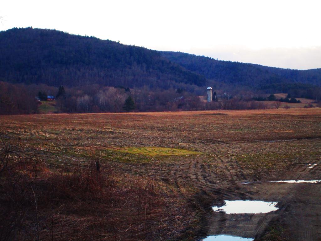
Below is a picture of fertile ag land the Batten Kill Valley, where i ended up hiking and exploring after a day looking at land not that far from there in Hoosick Falls, and deciding it was much too far away from work. But certainly that is god’s country, beautiful wonderful place, and the Folded Rock Trail is a great way to end a day, even if it was a cold March day. I could see living in the hills in a place like that, but not with a 5-day a week commute to the city.