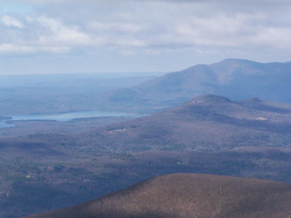
| Forest Cover by Catskill Park Unit | |||
| Unit | Deciduous Forest | Evergreen Forest | Mixed Forest |
|---|---|---|---|
| Balsam Lake Mountain Wild Forest | 51.3% | 1.7% | 44.4% |
| Beaverkill Campground | 48.2% | 12.2% | 29.9% |
| Belleayre Mountain Day Use Area | 53.4% | 0.3% | 13.1% |
| Belleayre Mountain Ski Center | 43.0% | 1.1% | 47.7% |
| Big Indian Wilderness | 62.1% | 0.7% | 36.6% |
| Bluestone Wild Forest | 47.2% | 7.6% | 37.2% |
| Colgate Lake Wild Forest | 27.7% | 19.2% | 47.8% |
| Delaware Wild Forest | 84.3% | 1.8% | 12.1% |
| Devil’s Tombstone Campground | 87.8% | 0.0% | 0.4% |
| Diamond Notch Primitive Bicycle Corridor | 56.5% | 0.0% | 43.5% |
| Dry Brook Ridge Wild Forest | 61.4% | 4.4% | 33.5% |
| Dutcher Notch Primitive Bicycle Corridor | 34.1% | 2.9% | 50.4% |
| Elm Ridge Wild Forest | 62.4% | 8.7% | 24.9% |
| Esopus Creek Fishing Access | 30.7% | 0.0% | 5.3% |
| Halcott Mountain Wild Forest | 48.1% | 1.1% | 50.4% |
| Hunter-West Kill Wilderness | 60.1% | 5.0% | 34.5% |
| Indian Head Wilderness | 51.3% | 8.1% | 40.1% |
| Kaaterskill Wild Forest | 53.3% | 7.1% | 38.6% |
| Kenneth L. Wilson Campground | 9.6% | 28.8% | 25.5% |
| Little Pond Campground | 79.5% | 0.9% | 10.8% |
| Mink Hollow Primitive Bicycle Corridor | 66.8% | 0.0% | 32.7% |
| Mongaup Pond Campground | 53.8% | 0.8% | 20.6% |
| North/South Lake Campground | 12.9% | 27.0% | 42.7% |
| Overlook Mountain Wild Forest | 65.1% | 1.3% | 33.3% |
| Overlook Turnpike Primitive Bicycle Corridor | 37.9% | 6.3% | 55.7% |
| Phoenicia – Mt. Tobias Wild Forest | 73.5% | 1.6% | 24.2% |
| Rusk Mountain Wild Forest | 62.4% | 2.8% | 34.6% |
| Shandaken Wild Forest | 90.7% | 0.9% | 7.5% |
| Slide Mountain Wilderness | 64.3% | 4.4% | 31.0% |
| Sundown Wild Forest | 64.5% | 3.8% | 27.9% |
| Unclassified | 63.8% | 2.6% | 32.1% |
| Willowemoc Wild Forest | 65.3% | 3.6% | 24.5% |
| Windham-Blackhead Range Wilderness | 47.9% | 5.3% | 46.3% |
| Woodland Valley Campground | 84.0% | 0.7% | 7.6% |
| Andy Arthur, 1/22/23. Data Source: 2019 National Land Cover Dataset. |
|||
Search Results for: shandaken wild forest

The Catskill Wilderness Areas

The text of today’s fodder is based on the Catskill Park State Lands Master Plan, as revised in 2008. Maps were rendered by myself, using Quantum GIS and DEC Lands and Forests data.
Big Indian Wilderness
(Formerly Big Indian – Beaverkill Range Wilderness Area)
This wilderness is located in the Towns of Hardenburgh, Denning and Shandaken in Ulster County. It lies generally west of Oliverea and the Frost Valley Road, south of Belleayre Ski Center, east of Seager and Hardenburgh and north of Willowemoc and Claryville. The area ranges in width from 1 to 5 miles, is about 19 miles long and contains approximately 33,500 acres of land. Elevations range from 1,500 feet in McKenley Hollow to 3,840 feet where the state boundary crosses Doubletop Mountain. The mountains in the northeastern portion of the area are quite rugged, while those to the south and west are more characteristic of high hills. Water from the area flows into three New York City water supply reservoirs and the Delaware River Basin. Nine mountains or ridges with elevations of over 3000 feet make up the area.
Peaks
Doubletop* 3,860′
Haynes 3,420′
Big Indian 3,700′
Spruce 3,380′
Fir 3,620′
Eagle 3,600′
Hemlock 3,240′
Balsam* 3,600′
Beaver Kill Range 3,377′
* Maximum elevations given are not necessarily located within the Wilderness Area.
The forest cover is predominantly hardwood mixtures in various associations. Spruce and fir, while present at some of the higher elevations, are less noticeable here than in other Catskill wilderness areas.
Interior facilities consisting of foot trails and lean-tos are generally considered adequate.
Area statistics:
Approximate Area 33,500 Acres
Roads (non conforming) 1.4 Miles
Foot Trails 29.4 Miles
Lean-tos 6
Designated Campsites 5
Parking Lots 5
Public Use (visitors/year) 4,500
Exterior Boundary Line 67 Miles
Minimum Elevation 1,500′
Maximum Elevation 3,840′
Non-conforming uses:
Motor vehicle use of Black Bear Road from the wilderness boundary to Fall Brook Lean-to.
A UMP for this area was completed in June of 1993.
Hunter – West Kill Wilderness
(Formerly West Kill – North Dome Wilderness, Ox Clove Wild Forest, and a portion of the former Hunter Mountain Wild Forest)
The unit generally lies within the following boundaries: New York State Route 42 on the west, the Shandakan Wild Forest and NYS Route 28 to the south, and NYS Route 214 on the east. The northern extent of the unit is County Route 6, and continues along a line 100′ parallel to, and south or east of, the edge of Spruceton trailhead parking area and the centerline of the Spruceton Truck Trail, to the junction of the Colonel’s Chair Trail. A corridor, 100 feet either side of the center line of the Spruceton Truck Trail, from the Colonel’s Chair Trail to the summit of Hunter Mountain, culminating in a circle 175′ in radius from the center of the chimney on the observer’s cabin shall be within the Rusk Mountain Wild Forest.
The unit contains approximately 27,000 acres of land, and inside it’s boundaries are found the named mountain peaks of Balsam, Sherrill, North Dome, West Kill, Sheridan, Hunter and Southwest Hunter. Hunter Mountain is the second highest peak in the Catskills at 4,040 feet, and portions of it’s summit, along with a fairly extensive area on the summits of West Kill, North Dome and Sherrill Mountains are within the Catskill High Peaks Bird Conservation Area, and are of special significance in that they provide habitat for high elevation spruce-fir inhabitants such as Bicknell’s Thrush and the Blackpoll Warbler, among others.
There are currently two lean-to’s on the unit, the Diamond Notch lean-to located just off the Diamond Notch Trail, and the Devil’s Acre Lean-to off of the Devil’s Path Trail. Waters from this unit drain into Schoharie and Esopus Creeks and then into the Schoharie and Ashokan Reservoirs, which are in the New York City water supply system.
Area statistics:
Approximate Area 27,000 Acres
Foot Trails 18 Miles
Lean-to’s 2
Parking Lots 5
Minimum Elevation 920′ Maximum Elevation 4,040′
Indian Head Wilderness
(Formerly Plateau Mountain – Indian Head Mountain Wilderness Area)
This wilderness is located in the Town of Hunter, Greene County and the Towns of Saugerties and Woodstock, Ulster County. It lies generally west of the east boundary of the Catskill Park, south of Platte Clove, east of Devil’s Tombstone Campground and north of Lake Hill and Shady. The area ranges from 1 ½ miles to 3 ½ miles in width, is eight miles long and contains approximately 16,800 acres.
Elevations range from 900 to 3840 feet and the four major mountains in the area are visible against the skyline from all directions. Echo Lake, the only natural lake in a Catskill wilderness, is located in the east-central portion of the area. Water from this eastern section flows into the Kingston and Saugerties water supply reservoirs, while drainage from the central and western section flows into two New York City water supply reservoirs. Six named mountain peaks over 3,000 feet in elevation dominate the area.
Peaks
Plateau 3,840′
Indian Head 3,573′
Sugarloaf 3,800′
Olderbark 3,440′
Twin 3,640′
Plattekill 3,100′
The forest cover varies from extensive oak stands on the eastern most slopes to mature spruce-fir on top of Plateau Mountain. An excellent mature stand of northern hardwood and hemlock occupies the slopes south of the Saw Kill.
Echo Lake, unique to the Catskill wilderness, is very popular for undeveloped camping. A small number of scattered primitive tent sites with fire rings have been established and public camping is limited to their capacities.
Public access is provided by several foot trails entering the area, including the old road from Meads to Overlook Mountain.
Area statistics:
Approximate Area 16,800 Acres
Roads 6.6 Miles
Foot Trails 24.1 Miles
Cross-country Ski Trails 5.6
Lean-tos 3
Designated Campsites 10
Parking Lots 1
Public Use (visitors/year) 8,000
Length of Boundary 33 Miles
Minimum Elevation 900′
Maximum Elevation 3,840′
A UMP for this area was completed in October of 1992.
Slide Mountain Wilderness
(Formerly Slide Mountain – Panther Mountain Wilderness Area)
This wilderness is located in the towns of Shandaken, Denning and Olive in Ulster County. It lies generally south of NYS Route 28, west of West Shokan, north of the Peekamoose Road (County Route 42) and east of the Frost Valley Road (County Route 47). It surrounds the Woodland Valley Campground and abuts the Sundown Wild Forest to its south. This area ranges from 1 to 10 miles in width, is about 13 miles long, and contains approximately 47,500 acres of land. The wilderness boundary is 118 miles long.
The terrain is rugged and steep with elevations ranging from 1,100 to 4,180 feet. All water draining from the area eventually reaches three New York City water supply reservoirs by way of the East and West Branches of the Neversink River, Rondout Creek and Esopus Creek. Twelve named mountain peaks with elevations over 3000 feet exist in the area. Of these, six may still be considered trail-less to the extent that they have no marked and maintained trails.
Peaks with Trails
Slide 4,180′
Peekamoose 3,843′
Cornell 3,860′
Wittenberg 3,780′
Table 3,847′
Panther 3,720′
Trail-less Peaks
Lone 3,721′
Rocky 3,508′
Friday 3,694′
Van Wyck 3,206′
Wildcat 3,340′
Balsam Cap 3,623′
The forest cover consists of nearly every possible mixture and association of hardwood and softwood trees native to the mountain region. While hardwoods predominate higher elevations are often covered with red spruce and balsam fir.
This area receives more public use than any other Catskill wilderness. Superb vistas are found on Slide, Wittenberg, Cornell, Giant Ledge and Panther Mountains. Access via foot trails is available from the north, south, east and west.
Area statistics:
Approximate Area 47,500 Acres
Foot Trails 35.3 Miles
Lean-tos 3
Parking Lots 10
Designated Campsites 29
Public Use (visitors/year) 23,000
Length of Boundary 118 Miles
Minimum Elevation 1,100′
Maximum Elevation 4,180′
A UMP for this area was completed in March of 1987 and revised in October of 1998.
Windham – Blackhead Range Wilderness
(Formerly Blackhead Range, and North Mountain Wild Forests, and portions of Windham High Peak, and Black Dome Valley Wild Forests)
The combination of these Wild Forest areas creates the Windham – Blackhead Range Wilderness Area, which lies within the Greene County towns of Cairo, Hunter, Jewett, Windham and Durham. The classification of these former Wild Forest areas was changed to Wilderness because their combined area comprises approximately 17,100 acres and contains rugged, high elevation land that clearly exhibits wilderness character. This newly classified area has seven named mountain peaks over 3,000 feet in elevation.
They are:
Peaks Black Dome 3,980′
Windham High Pk 3,520′
Blackhead 3,940′
Stoppel Point 3,420′
Thomas Cole 3,940′
Burnt Knob 3,180′
Acra Point 3,100′
The unit also contains six unnamed peaks over 3,000 feet, which range from 3,040 feet to 3,540 feet in elevation. Of the five highest peaks in the Catskills, three – Black Dome, Thomas Cole and Blackhead – are in this unit. This concentration of 13 peaks over 3,000 feet, within an area of approximately 28 square miles, with limited access, structures and improvements (30 miles of maintained foot trails and two lean-to’s) make the Windham – Blackhead Range Unit an area with excellent wilderness character.
A fairly extensive area of old growth forest can be found on this unit at the higher elevations, along the ridge stretching from an area west of Thomas Cole Mountain to Blackhead Mountain, and on Windham High Peak. The presence of this old growth forest, with its distinctive flora and fauna, add to the wilderness character of the unit. The unit also includes the headwaters of the Batavia Kill and, to the south over the Blackhead Range, the headwaters of the East Kill. Both of these rivers flow into Schoharie Creek, and are an integral part of the New York City Watershed system.
The western boundary of this unit shall be the east side of the Elm Ridge Trail, Black Dome Trail leaving it within the Elm Ridge Wild Forest, continuing north along the drainage to the Catskill Park boundary. The southern boundary of the unit shall be the Escarpment Trail approximately one half mile south of Stoppel Point to a point on the Escarpment Trail where it comes closest to the eastern Forest Preserve boundary. Both North Point and Stoppel Point will be within the Wilderness area. Lands to the south of the south edge of the Escarpment Trail in this area, will be in the Kaaterskill Wild Forest.
Because the Windham – Blackhead Range Wilderness surrounds the smaller Colgate Lake Wild Forest Unit, and because they are linked together by public use, the Unit Management Plans for the two units shall be contained in one document.
Area statistics:
Approximate Area 18,0000 Acres
Foot Trails 30 Miles
Lean-tos 2
Parking Lots 1
Minimum Elevation 980′
Maximum Elevation 3,980′


USGS Topographic Maps – Albany to Delaware Counties
Counties: Albany to Delaware / Dutchess to Livingston / Madison to Otsego / Putnam to Suffolk / Sullivan to Yates
Browse Topographic Maps: Full State / Historical USGS Topographic Maps
Albany County


Allegany County


Bronx County


Broome County


Cattaraugus County


Cayuga County


Chautauqua County


Chemung County


Chenango County


Clinton County


Columbia County


Cortland County


Delaware County


USGS Topographic Maps – Dutchess to Livingston Counties
Counties: Albany to Delaware / Dutchess to Livingston / Madison to Otsego / Putnam to Suffolk / Sullivan to Yates
Browse Topographic Maps: Full State / Historical USGS Topographic Maps
Dutchess County


Erie County


Essex County


Franklin County


Fulton County


Genesee County


Greene County


Hamilton County


Herkimer County


Jefferson County


Kings County


Lewis County


Livingston County


USGS Topographic Maps – Sullivan to Yates County
Counties: Albany to Delaware / Dutchess to Livingston / Madison to Otsego / Putnam to Suffolk / Sullivan to Yates
Browse Topographic Maps: Full State / Historical USGS Topographic Maps
Sullivan County


Tioga County


Tompkins County


Ulster County


Warren County


Washington County


Wayne County


Westchester County


Wyoming County


Yates County


List of Peaks in the Catskill Park
Below is a list of peaks within the Catskill Park that are on state land. This is based on the OpenStreetMap data combined with the DEC property data. Click location for a map of the property, or click State Land to get more information about the land the peak is located on.
Region 3 – Ulster County
Region 4 – Delaware County
Region 4 – Greene County


2017 NYSDEC Lean-To Listing
This lists out the 331 lean-tos with coordinates in the DEC's April 2017 release of Points of Interest Shapefile, that can be obtained from here: http://gis.ny.gov/gisdata/inventories/member.cfm?OrganizationID=529
| Location | Region | Facility | Name | Notes |
|---|---|---|---|---|
| 40.8977396062, -72.6606151038 |
1 | David A. Sarnoff Pine Barrens Preserve | Interior Lean- To | |
| 42.039846675, -74.593646931 |
3 | Balsam Lake Mountain Wild Forest | Balsam Lake Mountain Lean-To | |
| 42.0821851976, -74.5866114487 |
3 | Balsam Lake Mountain Wild Forest | Dry Brook Ridge Lean-To | |
| 42.0669125899, -74.6546347244 |
3 | Balsam Lake Mountain Wild Forest | Kelly Hollow Lean-To | |
| 42.0673682324, -74.5869876883 |
3 | Balsam Lake Mountain Wild Forest | Mill Brook Lean-To | |
| 42.0490509759, -74.644686588 |
3 | Balsam Lake Mountain Wild Forest | Mill Brook Ridge Lean-To | |
| 42.1150311581, -74.4907498238 |
3 | Belleayre Mtn Ski Center | East Ski Lean-To | |
| 42.1177186512, -74.5031992126 |
3 | Belleayre Mtn Ski Center | West Ski Lean-To | |
| 42.009105151, -74.4838519037 |
3 | Big Indian Wildernes Area | Biscuit Brook Lean-To | |
| 41.9980754336, -74.5603918334 |
3 | Big Indian Wildernes Area | Fall Brook Lean-To | |
| 42.0753394054, -74.4858565042 |
3 | Big Indian Wildernes Area | Mckinly Hollow Lean-To | |
| 42.0920121203, -74.50571316 |
3 | Big Indian Wildernes Area | Rider Hollow Lean-To | |
| 42.0502743293, -74.5106001667 |
3 | Big Indian Wildernes Area | Shandaken Brook Lean-To | |
| 42.0697505965, -74.2874492999 |
3 | Phoenicia – Mt. Tobias Wild Forest | Tremper Mountain Lean-To 1 | |
| 42.0719347774, -74.280350018 |
3 | Phoenicia – Mt. Tobias Wild Forest | Tremper Mountain Lean-To 2 | |
| 42.1388242073, -74.4544191301 |
3 | Shandaken Wild Forest | Rochester Hollow Lean-To | |
| 42.1027865494, -74.3948255307 |
3 | Slide Mountain Wilderness | Fox Hollow Lean-To | |
| 41.9591817103, -74.4068771821 |
3 | Slide Mountain Wilderness | Table Mountain Lean-To | |
| 42.0273156785, -74.3356447251 |
3 | Slide Mountain Wilderness | Terrace Mountain Lean-To | |
| 41.9400595492, -74.6320548238 |
3 | Willowemoc Wild Forest | Long Pond Lean-To | |
| 42.1584913515, -75.3620266032 |
4 | Arctic China State Forest | A-40 Lean-To | |
| 42.1528069973, -75.3102096425 |
4 | Barbour Brook State Forest | A-41 Lean To | |
| 42.2276166115, -75.3902198332 |
4 | Beals Pond State Forest | ||
| 42.3354251044, -73.4841812463 |
4 | Beebe Hill State Forest | Beebe Hill Lean-To | |
| 42.543303724, -74.4885945942 |
4 | Burnt-Rossman Hills State Forest | Eminence Lean-To | |
| 42.5282012278, -74.6420043552 |
4 | Clapper Hollow State Forest | Clapper Hollow Lean-To | |
| 42.0491041533, -74.9281738602 |
4 | Delaware Wild Forest | Cat Hollow Lean-To | |
| 42.0118726464, -74.9483763817 |
4 | Delaware Wild Forest | Mud Pond Trail Lean-To | |
| 42.0058597072, -74.8682131934 |
4 | Delaware Wild Forest | Pelnor Hollow Lean-To | |
| 42.0124988931, -74.9472696156 |
4 | Delaware Wild Forest | Trout Pond Trail Lean-To | Built For ADA |
| 42.6294376039, -74.2675434311 |
4 | Dutch Settlement State Forest | Lean-To | |
| 42.2197534864, -74.4391024687 |
4 | Halcott Mountain Wild Forest | Halcott Lean-To | |
| 42.313988005, -73.4414954693 |
4 | Harvey Mountain State Forest | Harvey Mountain Lean-To | |
| 42.1660752671, -74.2304343401 |
4 | Hunter-West Kill Wilderness | Devil’s Acre Lean-To | Good Condition |
| 42.1692897833, -74.2576582937 |
4 | Hunter-West Kill Wilderness | Diamond Notch Lean-To | |
| 42.3550413796, -74.3460668476 |
4 | Huntersfield State Forest | Lean-To | |
| 42.1196391066, -74.0873843029 |
4 | Indian Head Wilderness | Devils Kitchen Lean-To | |
| 42.0985881282, -74.0915994051 |
4 | Indian Head Wilderness | Echo Lake Lean-To | |
| 42.1357750354, -74.1634997793 |
4 | Indian Head Wilderness | Mink Hollow Lean-To | |
| 42.1894936316, -74.239507302 |
4 | Rusk Mountain Wild Forest | John Robb Lean-To | |
| 42.2789596573, -74.1033902943 |
4 | Windham Blackhead Range Wilderness | Batavia Kill Lean-To | |
| 42.3062546068, -74.1744107284 |
4 | Windham Blackhead Range Wilderness | Elm Ridge Lean-To | |
| 43.8755968409, -74.366426237 |
5 | Blue Mountain Wild Forest | O’neill Flow Lean-To | |
| 43.8873444776, -74.3788006261 |
5 | Blue Mountain Wild Forest | Tirrel Pond North Lean-To | |
| 43.829937473, -74.4366163022 |
5 | Blue Ridge Wilderness | Cascade Pond Lean-To | Fair |
| 43.8186736685, -74.4205248717 |
5 | Blue Ridge Wilderness | Stephens Pond Lean-To | Good |
| 43.8201917816, -74.4686803224 |
5 | Blue Ridge Wilderness | Wilson Pond Lean-To | Fair |
| 44.5989256982, -74.2285921246 |
5 | Debar Mtn. Wild Forest | Debar Mountian Lean-To | Debar Mtn Leanto |
| 44.4918501724, -74.2523227309 |
5 | Debar Mtn. Wild Forest | Grass Pond Lean-To | |
| 44.5192586399, -74.2710522386 |
5 | Debar Mtn. Wild Forest | Sheep Meadow Lean-To #1 | |
| 44.5193465505, -74.2711670085 |
5 | Debar Mtn. Wild Forest | Sheep Meadow Lean-To #2 | |
| 44.108205472, -73.7738312581 |
5 | Dix Mountain Wilderness | Bouquet Lean-To | |
| 44.0601596209, -73.8078167801 |
5 | Dix Mountain Wilderness | Lilian Brook Lean-To | |
| 44.044126198, -73.8058583966 |
5 | Dix Mountain Wilderness | Slide Brook Lean-To | |
| 44.1759172265, -73.7215350426 |
5 | Giant Mountain Wilderness | Giant Mtn. Lean-To | |
| 43.8863219437, -73.5641701351 |
5 | Hammond Pond Wild Forest | Eagle Lake Lean-To | |
| 43.9655912049, -73.6440374623 |
5 | Hammond Pond Wild Forest | Moose Mt Pond Lean-To | |
| 44.1447454969, -73.9547665307 |
5 | High Peaks Wilderness | Avalanche | |
| 44.1809734501, -73.8284043214 |
5 | High Peaks Wilderness | Bear Brook Lean-To | |
| 44.121015479, -73.9821264349 |
5 | High Peaks Wilderness | Beaver Point #1 | |
| 44.1207874446, -73.9817139904 |
5 | High Peaks Wilderness | Beaver Point #2 | |
| 44.1825279757, -74.1805220238 |
5 | High Peaks Wilderness | Blueberry Lean-To | |
| 44.1449655863, -73.8833895452 |
5 | High Peaks Wilderness | Bushnell Falls #1 Lean-To | |
| 44.1444007481, -73.8834828976 |
5 | High Peaks Wilderness | Bushnell Falls #2 Lean-To | |
| 44.1129718174, -73.9928913122 |
5 | High Peaks Wilderness | Calamity #1 Lean-To | |
| 44.1448580137, -74.2751710479 |
5 | High Peaks Wilderness | Calkin’s Brook Lean-To | |
| 44.1058294131, -74.3120366857 |
5 | High Peaks Wilderness | Calkin’s Creek Lean-To | |
| 43.9980126927, -74.3927845611 |
5 | High Peaks Wilderness | Catlin Bay #1 Lean-To | |
| 43.9972143811, -74.3959393656 |
5 | High Peaks Wilderness | Catlin Bay #2 Lean-To | |
| 44.1425166432, -74.1303582429 |
5 | High Peaks Wilderness | Cold River #2 Lean-To | |
| 44.091459278, -74.2576417508 |
5 | High Peaks Wilderness | Cold River #3 Lean-To | |
| 44.0913902533, -74.2557348025 |
5 | High Peaks Wilderness | Cold River #4 Lean-To | |
| 44.1427273763, -74.1298402107 |
5 | High Peaks Wilderness | Cold River Lean-To #1 Lean-To | |
| 44.1778467491, -73.833854921 |
5 | High Peaks Wilderness | Deer Brook Lean-To | |
| 44.141626874, -74.1069373468 |
5 | High Peaks Wilderness | Duck Hole #1 Lean-To | |
| 44.1416768647, -74.1065435467 |
5 | High Peaks Wilderness | Duck Hole #2 Lean-To | |
| 44.1142099053, -73.9556152329 |
5 | High Peaks Wilderness | Feldspar Lean-To | |
| 44.1186643668, -73.9840090128 |
5 | High Peaks Wilderness | Flowed Lands #2 Lean-To | |
| 44.1077341951, -73.9912056361 |
5 | High Peaks Wilderness | Griffin Lean-To | |
| 44.1773165403, -74.3218077012 |
5 | High Peaks Wilderness | Hemlock Hill Lean-To | |
| 44.1041784421, -74.0669132937 |
5 | High Peaks Wilderness | Henderson Lake Lean-To | |
| 44.1117549601, -74.0592189223 |
5 | High Peaks Wilderness | Henderson Lean-To | |
| 44.1178828905, -73.9873641274 |
5 | High Peaks Wilderness | Herbert Brook Lean-To | |
| 44.0026552882, -74.3864802633 |
5 | High Peaks Wilderness | Hidden Cove Lean-To | |
| 44.0760291647, -74.3235341651 |
5 | High Peaks Wilderness | Island House Lean-To | |
| 44.1494011459, -73.9557902347 |
5 | High Peaks Wilderness | Kagel Lean-To | |
| 44.0288002362, -74.367307986 |
5 | High Peaks Wilderness | Kelly Point #1 Lean-To | |
| 44.0287025672, -74.3671303487 |
5 | High Peaks Wilderness | Kelly Point #2 Lean-To | |
| 44.1706807759, -73.9050776091 |
5 | High Peaks Wilderness | Klondike Lean-To | |
| 44.1130126221, -73.9888393806 |
5 | High Peaks Wilderness | Livingston Point Lean-To | |
| 44.1469386475, -73.9552287453 |
5 | High Peaks Wilderness | Marcy Brook Lean-To | |
| 44.1579156535, -73.953395811 |
5 | High Peaks Wilderness | Marcy Dam #1 Lean-To | |
| 44.1573119259, -73.9533863686 |
5 | High Peaks Wilderness | Marcy Dam #2 Lean-To | |
| 44.1573817221, -73.9512823564 |
5 | High Peaks Wilderness | Marcy Dam #3 Lean-To | |
| 44.158399029, -73.9510719571 |
5 | High Peaks Wilderness | Marcy Dam #4 Lean-To | |
| 44.1586913289, -73.9524288871 |
5 | High Peaks Wilderness | Marcy Dam #5 Lean-To | |
| 44.1828433824, -74.0736410238 |
5 | High Peaks Wilderness | Moose Pond Lean-To | |
| 44.079589789, -74.2389368367 |
5 | High Peaks Wilderness | Moose Pond Stream Lean-To | |
| 44.0795538786, -74.2391509433 |
5 | High Peaks Wilderness | Moose Pond Stream Lean-To #2 | |
| 44.1992083493, -73.9059885406 |
5 | High Peaks Wilderness | Mr. Van Lean-To | |
| 44.0158171441, -74.1523218843 |
5 | High Peaks Wilderness | Newcomb Lake Lean-To #1 | |
| 44.0205306743, -74.1522782707 |
5 | High Peaks Wilderness | Newcomb Lake Lean-To #2 | |
| 44.1733720177, -74.1571389816 |
5 | High Peaks Wilderness | Number Four #1 Lean-To | |
| 44.1733860424, -74.1561240274 |
5 | High Peaks Wilderness | Number Four #2 Lean-To | |
| 44.1110695692, -73.9924324205 |
5 | High Peaks Wilderness | Opalescent Lean-To | |
| 44.1466502842, -73.8622440861 |
5 | High Peaks Wilderness | Ore Bed Brook Lean-To | |
| 44.1202212816, -74.1874471739 |
5 | High Peaks Wilderness | Ouluska Pass Brook Lean-To | |
| 44.0996351514, -73.9133647612 |
5 | High Peaks Wilderness | Panther Gorge Lean-To | |
| 44.0654422644, -74.3285192442 |
5 | High Peaks Wilderness | Plumley Point #1 Lean-To | |
| 44.0655989161, -74.3276122455 |
5 | High Peaks Wilderness | Plumley Point #2 Lean-To | |
| 44.1472355081, -74.318105399 |
5 | High Peaks Wilderness | Raquette Falls #1 Lean-To | |
| 44.1568302695, -74.3133083456 |
5 | High Peaks Wilderness | Raquette Falls #2 Lean-To | |
| 44.1710800022, -73.9974911766 |
5 | High Peaks Wilderness | Rocky Falls Lean-To | |
| 44.0414093849, -74.3501490964 |
5 | High Peaks Wilderness | Rodney Point #1 Lean-To | |
| 44.0429767454, -74.3493346475 |
5 | High Peaks Wilderness | Rodney Point #2 Lean-To | |
| 44.099413657, -74.1052871721 |
5 | High Peaks Wilderness | Santanoni Lean-To | |
| 44.159177638, -74.013876769 |
5 | High Peaks Wilderness | Scott Clearing Lean-To | |
| 44.1062441377, -74.2091536428 |
5 | High Peaks Wilderness | Seward Lean-To | |
| 44.1247329647, -73.9010796778 |
5 | High Peaks Wilderness | Slant Rock Lean-To | |
| 44.1988046777, -74.3183103111 |
5 | High Peaks Wilderness | Stony Creek Lean-To | |
| 44.1093110139, -73.961729679 |
5 | High Peaks Wilderness | Uphill Lean-To | |
| 44.1191510722, -73.9841831313 |
5 | High Peaks Wilderness | Walker Brook Lean-To | |
| 44.1221483174, -74.0532242803 |
5 | High Peaks Wilderness | Wallface Lean-To | |
| 44.1784419747, -74.1736369919 |
5 | High Peaks Wilderness | Ward Brook Lean-To | |
| 44.161824666, -73.8555947195 |
5 | High Peaks Wilderness | Wm. G. Howard Lean-To | |
| 44.1538919753, -73.8510077515 |
5 | High Peaks Wilderness | Wolf Jaw Lean-To | |
| 44.2530195934, -73.7180348153 |
5 | Hurricane Mountain Primitive Area | Gulf Brook Lean-To | Fair |
| 44.2607301476, -73.7100106669 |
5 | Hurricane Mountain Primitive Area | Lost Pond/Biesemeyer Lean-To | Fair |
| 43.5996600139, -73.5330643346 |
5 | Lake George Wild Forest | Black Mountain Ponds Lean-To | Lean-To With Privy And Fire Ring Black Mtn Pond Trail |
| 43.6193129088, -73.5841121844 |
5 | Lake George Wild Forest | Fifth Peak Lean-To | Lean-To W/ Privy And Fire Ring Tongue Mtn Range Trail |
| 43.5760391953, -73.5361031163 |
5 | Lake George Wild Forest | Fishbrook Pond North Lean-To | Leanto With Privy, Picnic Table And Fire Ring Fishbrook Pd-Lk Grg Shore Trl |
| 43.5738720148, -73.5384766731 |
5 | Lake George Wild Forest | Fishbrook Pond South Lean-To | Leanto With Privy, Picnic Table And Fire Ring Fishbrook Pd E Shore Trl |
| 43.6473357817, -73.5745337831 |
5 | Lake George Wild Forest | Five Mile Mountain Lean-To | Lean-To W/ Privy And Fire Ring Tongue Mtn Range Trail |
| 43.5778037953, -73.5168397538 |
5 | Lake George Wild Forest | Greenland Pond Lean-To | Leanto With Privy, Picnic Table And Fire Ring Greenland Pd Shelter Spur |
| 43.5958213341, -73.5179510245 |
5 | Lake George Wild Forest | Lapland Pond Lean-To | Campsite With Lean-To 13-27 Lapland Pond Lean-To Conector |
| 43.5871682823, -73.5277594231 |
5 | Lake George Wild Forest | Millman Pond Lean-To | Campsite With Lean-To 5-10 Old Farm To Millman Pond Trl |
| 44.3214560457, -74.0307860439 |
5 | Mckenzie Mtn. Wilderness | Placid Lean-To | |
| 44.3442169075, -73.9286469378 |
5 | Mckenzie Mtn. Wilderness | White Face Brook Lean-To | |
| 43.7790246336, -74.7044289121 |
5 | Moose River Plains Wild Forest | 8th Lake Island Lean-To | |
| 43.7801152974, -74.7044390115 |
5 | Moose River Plains Wild Forest | 8th Lake North Shore | |
| 43.7897826664, -74.6985922707 |
5 | Moose River Plains Wild Forest | 8thlake East Shore Lean-To | |
| 43.8316711731, -74.6617561796 |
5 | Moose River Plains Wild Forest | Beaver Bay Lean-To 1 | |
| 43.8316049364, -74.6615109228 |
5 | Moose River Plains Wild Forest | Beaver Bay Lean-To 2 | |
| 43.8314336654, -74.6609019165 |
5 | Moose River Plains Wild Forest | Beaver Bay Lean-To 3 | |
| 43.7478050188, -74.7441985068 |
5 | Moose River Plains Wild Forest | Seventh Lake Lean-To 1 | |
| 43.7507665118, -74.7346427944 |
5 | Moose River Plains Wild Forest | Seventh Lake Lean-To 2 | |
| 43.7563901134, -74.7178174969 |
5 | Moose River Plains Wild Forest | Seventh Lake Lean-To 3 | |
| 43.8145480145, -73.5808194792 |
5 | Pharaoh Lake Wilderness | Berrymill Pond Lean-To | Digitized From National Geographic Map |
| 43.8384100119, -73.5916749102 |
5 | Pharaoh Lake Wilderness | Clear Pond Lean-To | Digitized From National Geographic Map |
| 43.8412911595, -73.6316882519 |
5 | Pharaoh Lake Wilderness | Crab Pond Lean-To | Digitized From National Geographic Map |
| 43.8223693677, -73.5906397879 |
5 | Pharaoh Lake Wilderness | Grizzle Ocean Lean-To | Digitized From National Geographic Map |
| 43.8492027141, -73.6180024108 |
5 | Pharaoh Lake Wilderness | Lillypad Pond Lean-To | Digitized From National Geographic Map |
| 43.8500028762, -73.5895397847 |
5 | Pharaoh Lake Wilderness | Little Rock Pond Lean-To | Digitized From National Geographic Map |
| 43.8405296779, -73.6501782303 |
5 | Pharaoh Lake Wilderness | Oxshoe Pond Lean-To | Digitized From National Geographic Map |
| 43.7945783128, -73.6458567831 |
5 | Pharaoh Lake Wilderness | Pharaoh Lake #1 Lean-To | Digitized From National Geographic Map |
| 43.7966550547, -73.6403349616 |
5 | Pharaoh Lake Wilderness | Pharaoh Lake #2 Lean-To | Digitized From National Geographic Map |
| 43.8049450672, -73.6240085371 |
5 | Pharaoh Lake Wilderness | Pharaoh Lake #3 Lean-To | Digitized From National Geographic Map |
| 43.8049450672, -73.6240085371 |
5 | Pharaoh Lake Wilderness | Pharaoh Lake #3 Lean-To | Digitized From National Geographic Map |
| 43.8121074537, -73.6282851829 |
5 | Pharaoh Lake Wilderness | Pharaoh Lake #4 Lean-To | Digitized From National Geographic Map |
| 43.8021964679, -73.6391689125 |
5 | Pharaoh Lake Wilderness | Pharaoh Lake #5 Lean-To | Digitized From National Geographic Map |
| 43.8505590671, -73.5922949091 |
5 | Pharaoh Lake Wilderness | Rock Pond Lean-To | Digitized From National Geographic Map |
| 43.8581713271, -73.626483712 |
5 | Pharaoh Lake Wilderness | Tubmill Marsh Lean-To | Digitized From National Geographic Map |
| 44.3961331068, -74.3704212658 |
5 | Saint Regis Canoe Area | Fish Pond Site 2 Lean-To | Saint Regis Mountain |
| 44.3913013571, -74.3658071555 |
5 | Saint Regis Canoe Area | Fish Pond Site 5 Lean-To | New Lean-To Built Sept. 2010,Relocated Further From Water |
| 44.3808655111, -74.3200340382 |
5 | Saint Regis Canoe Area | St. Regis Pond Site 3 Lean-To | Lean-To Too Close To Water, Need To Move Back When Major Work Is Needed |
| 44.3250945507, -74.3498966646 |
5 | Saranac Lakes Wild Forest | Follensby Clear Lean-To | |
| 44.2866574735, -74.1626018103 |
5 | Saranac Lakes Wild Forest | Kiwasa Lake Site 3 Lean-To | |
| 44.3322955804, -73.9566258523 |
5 | Saranac Lakes Wild Forest | Lake Placid Site 2 Lean-To | Lake Placid |
| 44.3325954268, -73.9566801194 |
5 | Saranac Lakes Wild Forest | Lake Placid Site 3 Lean-To | Lake Placid |
| 44.2253525405, -74.3803783852 |
5 | Saranac Lakes Wild Forest | Raquette Lean-To | Built In 2013 Relocated From Trombley Landing Site |
| 44.3092299998, -74.1801499997 |
5 | Saranac Lakes Wild Forest | Saranac Islands Site 2 Lean-To | |
| 44.2890999998, -74.2172199999 |
5 | Saranac Lakes Wild Forest | Saranac Islands Site 45 Lean-To | |
| 44.2666999994, -74.2447999995 |
5 | Saranac Lakes Wild Forest | Saranac Islands Site 63 Lean-To | |
| 44.2729500004, -74.27398 |
5 | Saranac Lakes Wild Forest | Saranac Islands Site 81 Lean-To | |
| 44.2878799998, -74.2885399997 |
5 | Saranac Lakes Wild Forest | Saranac Islands Site 87 Lean-To | |
| 44.2287716477, -74.3755334312 |
5 | Saranac Lakes Wild Forest | Trombley Landing Lean-To | |
| 44.3028866826, -74.3026336593 |
5 | Saranac Lakes Wild Forest | Upper Saranac Lake Lean-To | |
| 43.8161997506, -74.6446678086 |
5 | Sargent Ponds Wild Forest | Big Island Lean-To 1 | |
| 43.8170896757, -74.6432509546 |
5 | Sargent Ponds Wild Forest | Big Island Lean-To 2 | |
| 43.8171339137, -74.6437800321 |
5 | Sargent Ponds Wild Forest | Big Island Lean-To 3 | |
| 43.8707715776, -74.6285067054 |
5 | Sargent Ponds Wild Forest | Boucher Point Lean-To #1 | |
| 43.8710064606, -74.6281079204 |
5 | Sargent Ponds Wild Forest | Boucher Point Lean-To #2 | |
| 43.8707202965, -74.629171869 |
5 | Sargent Ponds Wild Forest | Boucher Point Lean-To #3 | |
| 44.1027442039, -74.321862706 |
5 | Sargent Ponds Wild Forest | Deep Hole Lean-To | |
| 43.9262175397, -74.4753958672 |
5 | Sargent Ponds Wild Forest | Deerland Carry # 2 Lean-To | Fair Condition |
| 43.9257807189, -74.4758457554 |
5 | Sargent Ponds Wild Forest | Deerland Carry #1 Lean-To | Fair Condition |
| 43.9028470717, -74.5480629364 |
5 | Sargent Ponds Wild Forest | Forked Lake Lean-To | |
| 44.0814068183, -74.3358291461 |
5 | Sargent Ponds Wild Forest | Long Lake Nw Lean-To #1 | |
| 44.0825043385, -74.3339145725 |
5 | Sargent Ponds Wild Forest | Long Lake Nw Lean-To #2 | |
| 43.8593314968, -74.5626945075 |
5 | Sargent Ponds Wild Forest | Lower Sargents Pond Lean-To | Fair Condition |
| 43.8794136061, -74.6060523536 |
5 | Sargent Ponds Wild Forest | Outlet Bay Lean-To | Hit By Tree, 2011 |
| 43.9066458928, -74.5025901551 |
5 | Sargent Ponds Wild Forest | Pinebrook Lean-To | Fair Condition |
| 43.8368984989, -74.5352656022 |
5 | Sargent Ponds Wild Forest | Utowana Lake Lean-To | |
| 44.3317122951, -73.8997103538 |
5 | Sentinel Range Wilderness | Copperas Pond Lean-To | |
| 43.2171873383, -74.3641178087 |
5 | Shaker Mountain Wild Forest | Chase Lake Lean-To | |
| 43.1885867657, -74.4310218123 |
5 | Shaker Mountain Wild Forest | Holmes Lake Lean-To | |
| 43.6161332228, -74.1506253912 |
5 | Siamese Ponds Wilderness | E. Sacandaga River Lean-To | |
| 43.7007731961, -74.1581732825 |
5 | Siamese Ponds Wilderness | Hour Pond Lean-To | |
| 43.7278247362, -74.2012685562 |
5 | Siamese Ponds Wilderness | John Pond Lean-To | |
| 43.6775543215, -74.1916025718 |
5 | Siamese Ponds Wilderness | Puffer Pond #1 Lean-To | |
| 43.6765395437, -74.1997399401 |
5 | Siamese Ponds Wilderness | Puffer Pond #2 Lean-To | |
| 43.3974135952, -74.45529759 |
5 | Silver Lake Wilderness | Hamilton Lake Stream #1 Lean-To | |
| 43.3426710732, -74.4562907856 |
5 | Silver Lake Wilderness | Mud Lake Lean-To | |
| 43.2919354568, -74.4237351677 |
5 | Silver Lake Wilderness | Silver Lake Lean-To | |
| 44.4897002134, -73.8614267379 |
5 | Taylor Pond Wild Forest | North Shore Taylor Pond Lean-To | Managed By Operations |
| 44.4776887718, -73.881283087 |
5 | Taylor Pond Wild Forest | Northwest Shore Taylor Pond Lean-To | Managed By Operations |
| 44.3997973549, -73.5145569962 |
5 | Taylor Pond Wild Forest | Poke-O-Moonshine Summit Lean-To | |
| 44.4828880086, -73.8537772441 |
5 | Taylor Pond Wild Forest | South East Taylor Pond Lean-To | Managed By Operations |
| 43.9326741166, -73.9690844017 |
5 | Vanderwhacker Mountain Wild Forest | Cheney Pond Lean-To | |
| 43.8387348153, -73.9856219154 |
5 | Vanderwhacker Mountain Wild Forest | Stony Pond Lean-To | |
| 43.6259693968, -74.5492715037 |
5 | West Canada Lake Wilderness | Beaver Pond (AKA Cedar Lakes Lean-To #2) | |
| 43.6787448835, -74.4954982188 |
5 | West Canada Lake Wilderness | Carry Lean-To | |
| 43.628125665, -74.5404732399 |
5 | West Canada Lake Wilderness | Cedar Lakes #1 Lean-To | |
| 43.6084635843, -74.559724172 |
5 | West Canada Lake Wilderness | Cedar Lakes #3 Lean-To | |
| 43.6524139144, -74.4903803529 |
5 | West Canada Lake Wilderness | Colvin Brook Lean-To | |
| 43.5968984709, -74.5316653645 |
5 | West Canada Lake Wilderness | Pillsbury Lake Lean-To | |
| 43.5807608964, -74.576533363 |
5 | West Canada Lake Wilderness | Sampson Lake Lean-To | |
| 43.5872448097, -74.6215788384 |
5 | West Canada Lake Wilderness | South Lake Lean-To | |
| 43.5272841126, -74.6099246975 |
5 | West Canada Lake Wilderness | Spruce Lake #1 Lean-To | |
| 43.5346306298, -74.6080858031 |
5 | West Canada Lake Wilderness | Spruce Lake #2 Lean-To | |
| 43.5371297279, -74.608209628 |
5 | West Canada Lake Wilderness | Spruce Lake #3 Lean-To | |
| 43.4527175892, -74.5822815394 |
5 | West Canada Lake Wilderness | T Lake Lean-To | |
| 43.586987614, -74.613997971 |
5 | West Canada Lake Wilderness | West Canada Creek Lean-To | |
| 43.5931622288, -74.6268866843 |
5 | West Canada Lake Wilderness | West Lake #1 Lean-To | |
| 43.5970642572, -74.6231056496 |
5 | West Canada Lake Wilderness | West Lake #2 Lean-To | |
| 43.5102617091, -74.0492883971 |
5 | Wilcox Lake Wild Forest | Lizard Pond Lean-To | Digitized From National Geographic Map |
| 43.3363734227, -74.2173211966 |
5 | Wilcox Lake Wild Forest | Murphy Lake Lean-To | Digitized From National Geographic Map |
| 43.396075559, -74.1532214824 |
5 | Wilcox Lake Wild Forest | Wilcox Lake #1 Lean-To | Digitized From National Geographic Map |
| 43.39859675, -74.1554639493 |
5 | Wilcox Lake Wild Forest | Wilcox Lake #2 Lean-To | Digitized From National Geographic Map |
| 44.0021452737, -74.7756817712 |
5 | William C. Whitney Wilderness | Lake Lila # 7 Lean-To | |
| 44.4244015852, -73.8486868866 |
5 | Wilmington Wild Forest | Cooper Kill Lean-To | Too Close To Water, Need To Replocate, Do Not Repair |
| 44.1070894301, -75.0674448544 |
6 | Aldrich Pond Wild Forest | Streeter Lake Lean-To | Wood |
| 43.7434886212, -74.8776068003 |
6 | Alger Island Campground | Campsite # 01 | |
| 43.7443528827, -74.8771318496 |
6 | Alger Island Campground | Campsite # 02 | |
| 43.7456011181, -74.8768832894 |
6 | Alger Island Campground | Campsite # 03 | |
| 43.7466942129, -74.8745145576 |
6 | Alger Island Campground | Campsite # 04 | |
| 43.746535972, -74.8735980503 |
6 | Alger Island Campground | Campsite # 05 | |
| 43.7467703384, -74.8722666576 |
6 | Alger Island Campground | Campsite # 06 | |
| 43.7465482669, -74.8718037808 |
6 | Alger Island Campground | Campsite # 07 | |
| 43.7458848539, -74.8729191925 |
6 | Alger Island Campground | Campsite # 08 | |
| 43.7454701717, -74.8727721949 |
6 | Alger Island Campground | Campsite # 09 | |
| 43.7450840439, -74.8725955649 |
6 | Alger Island Campground | Campsite # 10 | |
| 43.744783668, -74.8724088972 |
6 | Alger Island Campground | Campsite # 11 | |
| 43.7441622435, -74.8727256743 |
6 | Alger Island Campground | Campsite # 12 | |
| 43.7440135576, -74.8739878218 |
6 | Alger Island Campground | Campsite # 13 | |
| 43.7431429387, -74.875172598 |
6 | Alger Island Campground | Campsite # 14 | |
| 43.7428736074, -74.8760835968 |
6 | Alger Island Campground | Campsite # 15 | |
| 43.6000735406, -75.0530032053 |
6 | Black River Wild Forest | Bear Lake Lean-To | |
| 43.5245079024, -75.0409215605 |
6 | Black River Wild Forest | Chub Pond #1 Lean-To | Rehabbed In 2008 |
| 43.5298225654, -75.0424937056 |
6 | Black River Wild Forest | Chub Pond #2 Lean-To | Built By Lean-To Permit 1963, Taken Care Of By Plumley Family |
| 43.5537469236, -75.059377614 |
6 | Black River Wild Forest | Gull Lake Lean-To | |
| 43.5341150034, -74.9280935302 |
6 | Black River Wild Forest | Lean-To | |
| 43.6299248982, -75.0362877527 |
6 | Black River Wild Forest | Remsen Falls Lean-To | Rehabbed In 2008 |
| 43.5589136946, -75.0030576033 |
6 | Black River Wild Forest | Sand Lake Falls Lean-To | Rehabbed In 2008 |
| 43.5998849075, -75.0203817469 |
6 | Black River Wild Forest | Woodhull Lake Lean-To | Rehabbed In 2008, Double Sized Lean-To |
| 43.6520754244, -75.0592470923 |
6 | Black River Wildforest | Nelson Lake Trail Lean-To | |
| 43.3445446485, -75.6722203255 |
6 | Cobb Brook State Forest | Leanto | |
| 44.1990987752, -74.8148790735 |
6 | Cranberry Lake Wild Forest | Bear Mountain Lean-To | |
| 44.2105729246, -74.7181527787 |
6 | Cranberry Lake Wild Forest | Burntbridge Pond Lean-To | |
| 44.1533999108, -74.8840290725 |
6 | Cranberry Lake Wild Forest | Ranger School Lean-To | Campsite 41 Aka Inlet Flow Lean-To |
| 44.0529214425, -74.9471939334 |
6 | Five Ponds Wilderness | Big Shallow Lean-To | Cs 30 |
| 44.0528916324, -75.0090580588 |
6 | Five Ponds Wilderness | Cage Lake Lean-To | |
| 44.0931113064, -74.8498397365 |
6 | Five Ponds Wilderness | Cowhorn Pond Lean-To | |
| 44.1123581654, -74.8914922468 |
6 | Five Ponds Wilderness | Janacks Landing Lean-To | With Full Sized Privy |
| 44.0474525004, -74.9526919257 |
6 | Five Ponds Wilderness | Little Shallow Lean-To | Cs 30 |
| 44.1198328093, -74.8454890242 |
6 | Five Ponds Wilderness | Olmstead Pond Lean-To | With Full Sized Privy |
| 44.0689970407, -74.9112845696 |
6 | Five Ponds Wilderness | Oswegatchie River Site 13 Lean-To | Cs 13 Lt |
| 44.0688665373, -74.9093532798 |
6 | Five Ponds Wilderness | Oswegatchie River Site 15 Lean-To | Cs 15 Lt |
| 44.0746275016, -74.9613775006 |
6 | Five Ponds Wilderness | Oswegatchie River Site 34 Lean-To | Cs 34 Lt |
| 44.0843538607, -74.9687312803 |
6 | Five Ponds Wilderness | Oswegatchie River Site 38 Lean-To | Cs 38 Lt |
| 44.0154640897, -75.0054753701 |
6 | Five Ponds Wilderness | Sand Lake Lean-To | Cs 30 |
| 43.9284894776, -74.9448704212 |
6 | Five Ponds Wilderness | Trout Pond Lean-To | |
| 43.9284894776, -74.9448704212 |
6 | Five Ponds Wilderness | Trout Pond Lean-To | |
| 44.0299676783, -74.9801386129 |
6 | Five Ponds Wilderness | Wolf Lake Lean-To | Cs 30 |
| 43.7029255425, -75.0960024266 |
6 | Haderondah | Middle Branch Lake Lean-To | |
| 43.6859486954, -75.0986138399 |
6 | Haderondah | Middle Settlement Lake Lean-To | |
| 44.1511613292, -74.5657606156 |
6 | Horseshoe Lake Wild Forest | Black Bay Lean-To | Checked 11/2015 |
| 44.196860294, -74.5121752893 |
6 | Horseshoe Lake Wild Forest | Eagle Landing Lean-To | Tupper Lake Site #5 |
| 43.8235350455, -75.1693122081 |
6 | Independence River Wild Forest | Panther Pond Lean-To | |
| 43.7083935125, -75.14645298 |
6 | Independence River Wild Forest | Pine Lake Lean-To | |
| 43.8089062032, -75.474955964 |
6 | Lowville Demonstration Area | Lowville Forestry Demonstration Area | |
| 43.8558345419, -74.804220953 |
6 | Pigeon Lake Wilderness | Andes Creek Lean-To | |
| 43.8575116443, -74.8252446695 |
6 | Pigeon Lake Wilderness | Gull Lake Lean-To | |
| 43.8764050748, -74.7655286668 |
6 | Pigeon Lake Wilderness | Lower Sister Lake Lean-To | |
| 43.8421644493, -74.8055993839 |
6 | Pigeon Lake Wilderness | Russian Lake Lean-To | |
| 43.8139160683, -74.7983685471 |
6 | Pigeon Lake Wilderness Area | Queer Lake Lean-To | Campsite With Lean-To |
| 43.8348742486, -75.8607286637 |
6 | Tug Hill State Forest | Electric Loop Lean-Too | Wooden Lean-Too Built In 1982, By Steve Wood Troop 7 |
| 44.3578220602, -75.3160008277 |
6 | Wolf Lake State Forest | Beaver Flow Lean-To | Beaver Flow Leanto |
| 44.3242717044, -75.3337383742 |
6 | Wolf Lake State Forest | Huckleberry Lake Lean-To | Huckleberry Lake Leanto |
| 44.3322757137, -75.3211717792 |
6 | Wolf Lake State Forest | Moon Pond Lean-To | Moon Lake Leanto |
| 44.3322757137, -75.3211717792 |
6 | Wolf Lake State Forest | Moon Pond Lean-To | Moon Lake Leanto |
| 44.3322757137, -75.3211717792 |
6 | Wolf Lake State Forest | Moon Pond Lean-To | Moon Lake Leanto |
| 44.3322757137, -75.3211717792 |
6 | Wolf Lake State Forest | Moon Pond Lean-To | Moon Lake Leanto |
| 44.3363136709, -75.313863327 |
6 | Wolf Lake State Forest | Wolf Lake Lean-To | Wolf Lake Leanto |
| 42.746653083, -75.3797255193 |
7 | Charles E. Baker State Forest | Trail 17 Lean-To | Primitive Campsite With Fire Pit |
| 42.7627233838, -75.379619514 |
7 | Charles E. Baker State Forest | Woodland Pond Lean-To | Primitive Campsite With Hore Tie Rail And Fire Pit |
| 42.3270424066, -76.4900608723 |
7 | Danby State Forest | Chestnut Lean-To | |
| 42.3176423354, -76.4225442513 |
7 | Danby State Forest | Tamarack Lean-To | |
| 42.8201846305, -75.8591052772 |
7 | Deruyter State Forest | Deruyter Lean-To | |
| 42.4228873052, -75.7674346807 |
7 | Genegantslet State Forest | Top Ten Lean-To | 20′ X 20′ Log Cabin |
| 42.4728525684, -76.1787322193 |
7 | Kennedy State Forest | Foxfire Lean-To | |
| 42.4458019158, -75.7015069607 |
7 | Ludlow Creek State Forest | Ludlow Creek Lean-To | 8′ X 10′ Constructed 2002 |
| 42.723126977, -75.8709545002 |
7 | Mariposa State Forest | Mariposa Finger Lakes Lean-To | |
| 42.7672022335, -76.0112561891 |
7 | Morgan Hill State Forest | Morgan Hill Lean-To | |
| 42.6423073773, -75.7437663179 |
7 | Perkins Pond State Forest | Flt Lean-To Lean-To | |
| 42.3905962266, -76.2718006242 |
7 | Robinson Hollow State Forest | Kimme Lean-To | |
| 42.3276442724, -76.3290355678 |
7 | Shindagin Hollow State Forest | Shindagin Lean-T0 | Scheduled For Replacement In 2004 |
| 42.5122011517, -76.1208238604 |
7 | Tuller Hill State Forest | Woodchuck Hollow Lean-To | Rebuilt In 2002 From Local State Forest Red Pine, Built By Volunteers From Suny Cortland |
| 42.6060629372, -75.4671141039 |
7 | Whaupaunaucau State | Leanto | |
| 42.3132130609, -77.5663734584 |
8 | Burt Hill State Forest | On Finger Lake Trail Lean-To | |
| 42.625051213, -77.3586638233 |
8 | High Tor Wma | High Tor North Lean-To | Campsite With Stone Firepit And Privy Updated By Emily Bonk Forest Tech |
| 42.6146971076, -77.3661109424 |
8 | High Tor Wma | High Tor South Lean-To | Campsite With Firepit And Privy Updated By Emily Bonk Forest Tech |
| 42.0965007548, -77.1964378403 |
8 | Mccarthy Hill State Forest | Mccarthy Hill Leanto | Built By Fltc 2012 |
| 42.2891155929, -77.1188809327 |
8 | South Bradford State Forest | Moss Hill Lean-To | |
| 42.3730816642, -76.9554800047 |
8 | Sugar Hill State Forest | Buck Settlement Lean-To | Built 2006 By Fltc |
| 42.369515888, -77.0127591279 |
8 | Sugar Hill State Forest | Parks Hollow Lean-To | |
| 42.3690917205, -77.0130036276 |
8 | Sugar Hill State Forest | Parks Hollow Lean-To | Log Built 2011 |
| 42.3822533326, -77.0026799995 |
8 | Sugar Hill State Forest | The Twin Lean-To’s | 2 Lean-To At This Location |
| 42.3898077706, -76.9725898373 |
8 | Sugar Hill State Forest | Vanzandt Lean-To | |
| 42.3340314562, -78.532889311 |
9 | Boyce Hill State Forest | Flt Lean To | Log Lean To Built In 2012 By Flt Club |
| 42.53472215, -73.9623319605 |
Cabins | |||
| 42.3492343019, -77.8075299409 |
Flt |

