| Type |
Name |
Description |
Coordinates |
| Hand Launch |
Ceder River Flow Boat Ramp |
Hand Carry Launch, Ramp |
43.725826369700904, -74.47289916126694 |
| Lean-To |
Beaver Pond (Aka Cedar Lakes Lean-To #2) |
|
43.625969396804386, -74.54927150370021 |
| Lean-To |
Carry Lean-To |
|
43.67874488347091, -74.49549821879448 |
| Lean-To |
Catlin Bay #1 Lean-To |
|
43.99801269269887, -74.39278456108421 |
| Lean-To |
Cedar Lakes #1 Lean-To |
|
43.628125665037935, -74.54047323992656 |
| Lean-To |
Cold River #2 Lean-To |
|
44.14251664317184, -74.13035824291548 |
| Lean-To |
Cold River #3 Lean-To |
|
44.091459278051204, -74.25764175084498 |
| Lean-To |
Cold River #4 Lean-To |
|
44.09139025333258, -74.25573480252505 |
| Lean-To |
Cold River Lean-To #1 Lean-To |
|
44.14272737628489, -74.12984021065587 |
| Lean-To |
Duck Hole #1 Lean-To |
|
44.14162687400988, -74.10693734676616 |
| Lean-To |
Duck Hole #2 Lean-To |
|
44.14167686466829, -74.10654354672256 |
| Lean-To |
Hamilton Lake Stream #1 Lean-To |
|
43.39741359517532, -74.45529759002217 |
| Lean-To |
Hidden Cove Lean-To |
|
44.00265528819394, -74.38648026325164 |
| Lean-To |
Kelly Point #1 Lean-To |
|
44.02880023617087, -74.36730798599064 |
| Lean-To |
Kelly Point #2 Lean-To |
|
44.02870256717196, -74.36713034867948 |
| Lean-To |
Moose Pond Lean-To |
|
44.182843382402666, -74.07364102375995 |
| Lean-To |
Mud Lake Lean-To |
|
43.342671073157994, -74.45629078563864 |
| Lean-To |
O’neill Flow Lean-To |
|
43.875596840936154, -74.36642623697053 |
| Lean-To |
Ouluska Pass Brook Lean-To |
|
44.120221281603584, -74.18744717390932 |
| Lean-To |
Plumley Point #2 Lean-To |
|
44.06559891610762, -74.32761224546002 |
| Lean-To |
Rodney Point #1 Lean-To |
|
44.04140938489936, -74.35014909639557 |
| Lean-To |
Rodney Point #2 Lean-To |
|
44.042976745412616, -74.34933464753136 |
| Lean-To |
Seward Lean-To |
|
44.106244137686204, -74.2091536427719 |
| Lean-To |
Silver Lake Lean-To |
|
43.29193545679836, -74.4237351676776 |
| Lean-To |
South Lake Lean-To |
|
43.58724480971, -74.62157883837274 |
| Lean-To |
Spruce Lake #1 Lean-To |
|
43.52728411257782, -74.6099246975027 |
| Lean-To |
Spruce Lake #2 Lean-To |
|
43.53463062983387, -74.60808580306896 |
| Lean-To |
Spruce Lake #3 Lean-To |
|
43.53712972792447, -74.60820962802477 |
| Lean-To |
Stephens Pond Lean-To |
|
43.818673668554965, -74.42052487172707 |
| Lean-To |
Tirrel Pond North Lean-To |
|
43.887344477557306, -74.37880062606054 |
| Lean-To |
West Canada Creek Lean-To |
|
43.58698761405157, -74.61399797100106 |
| Lean-To |
West Lake #1 Lean-To |
|
43.59316222884976, -74.62688668431306 |
| Lean-To |
West Stony Creek Lean-To |
|
43.22474428954461, -74.26933345717664 |
| Paved Parking Lot |
Lake Durant Northville Placid Trail Parking Lot |
Paved, 12 Vehicle Capacity |
43.84219550506574, -74.3862742856788 |
| Paved Parking Lot |
Northville Lake Placid Trail Parking Lot |
Paved, Good Condition |
43.84213270187873, -74.38656792328511 |
| Primitive Tent Site |
Canary Pond Campsite |
|
43.30513256312245, -74.4472062440692 |
| Primitive Tent Site |
Cedar Lake Dam 1 |
|
43.62894580965635, -74.53639939387939 |
| Primitive Tent Site |
Cedar Lake Dam Tentsite |
|
43.62937624507422, -74.53679785644344 |
| Primitive Tent Site |
Cedar River Flow Tentsite |
|
43.70292480315104, -74.48713041165333 |
| Primitive Tent Site |
Fall Stream Tentsites |
|
43.49661052800474, -74.53713112743992 |
| Primitive Tent Site |
Jessup River Tentsites |
|
43.51246207852797, -74.57229710138834 |
| Primitive Tent Site |
Kelly Point Tentsites |
|
44.02910364406153, -74.36670207204214 |
| Primitive Tent Site |
Moose Pond Tentsites |
|
44.18274441156179, -74.07408240028583 |
| Primitive Tent Site |
Moose River Plains Campsite 01 |
Live |
43.72667672123972, -74.47410026642402 |
| Primitive Tent Site |
Moose River Plains Campsite 02 |
Live |
43.72665150100841, -74.47331107300782 |
| Primitive Tent Site |
Moose River Plains Campsite 03 |
Live |
43.725959512295866, -74.47389996564202 |
| Primitive Tent Site |
Moose River Plains Campsite 04 |
Live |
43.726067692208126, -74.47423264719026 |
| Primitive Tent Site |
Moose River Plains Campsite 05 |
Live |
43.725563790898704, -74.47417512282912 |
| Primitive Tent Site |
Moose River Plains Campsite 06 |
Live |
43.72522313374867, -74.47458303719159 |
| Primitive Tent Site |
Mud Lake Tentsites |
|
43.59647433847274, -74.61354076182431 |
| Primitive Tent Site |
O’neill Flow Tentsite |
|
43.87567135918534, -74.3666467203306 |
| Primitive Tent Site |
Rock Lake Campsite |
|
43.265591839994535, -74.41543516012669 |
| Primitive Tent Site |
Salmon River Tentsites |
|
43.907925071619914, -74.38530801916977 |
| Primitive Tent Site |
Shattuck Clearing Tentsites |
|
44.08679657756681, -74.26368397541134 |
| Primitive Tent Site |
Silver Lake Tent Site |
|
43.29112770008321, -74.4240469986026 |
| Primitive Tent Site |
Spruce Lake Tentsite |
|
43.53695545329776, -74.60818912022354 |
| Primitive Tent Site |
Tirrell Pond North Tentsites |
|
43.88594343639596, -74.37834897628142 |
| Primitive Tent Site |
Trailside Campsite |
|
43.2716741112023, -74.43107546264162 |
| Primitive Tent Site |
Wanika Falls Tentsites |
|
44.19944690357389, -74.05663862305364 |
| Primitive Tent Site |
West Lake Former Caretaker Clearing Tentsites |
|
43.59389874347195, -74.62560220247346 |
| Primitive Tent Site |
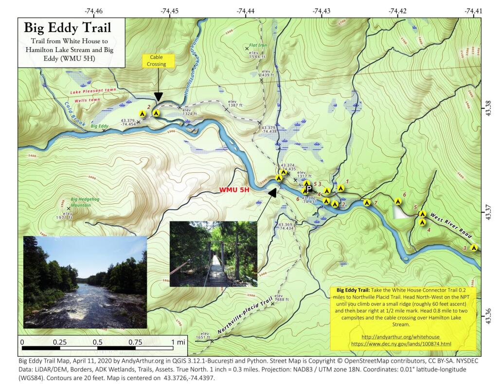
Whitehouse Campsite |
|
43.373430193527696, -74.43578942968477 |
| Primitive Tent Site |
Whitehouse Campsite |
|
43.37406302094423, -74.43516794694158 |
| Primitive Tent Site |
Woods Lake Campsite #2 |
Fire Pit, Water Front Campsite |
43.25071034607129, -74.31177480398298 |
| Primitive Tent Site |
Woods Lake Campsite #3 |
Fire Ring, Water Front Tentsite, Scenic View |
43.250888826581715, -74.31104030228295 |
| Primitive Tent Site |
Woods Lake Campsite #4 |
Fire Place, Water Front Campsite, Nice View |
43.251811433787196, -74.3092782205918 |
| Unpaved Parking Lot |
Benson Road Parking Area |
8 Vehicle Capacity |
43.24745928673895, -74.31187044250609 |
| Unpaved Parking Lot |
Chubb River Bridge |
|
44.2628824981147, -74.01364844250504 |
| Unpaved Parking Lot |
Moose River Recrieation Area |
Northville-Placid And Cedar River Trails |
43.726457025366315, -74.47386984656715 |
| Unpaved Parking Lot |
Norhtville Placid Parking-Haskells Rd |
|
43.45841038153893, -74.52201705350714 |
| Unpaved Parking Lot |
Northville Placid Trail Parking Area |
6 Car Interior Parking Area |
43.21330828950083, -74.2083824784703 |
| Unpaved Parking Lot |
Northville Placid Trail Route 28n Parking Lot |
|
43.97584466308438, -74.39296138679799 |
| Unpaved Parking Lot |
Tarbell Road Shoulder Parking Lot |
|
43.984346733793245, -74.39813014848872 |
| Unpaved Parking Lot |
Wakely Dam |
|
43.72640808237045, -74.47425964611213 |
| Unpaved Parking Lot |
Wakely Mountain Trailhead Parking Lot |
1250 Sq Feet |
43.732197733217824, -74.47253968128065 |
| Unpaved Parking Lot |
Wakely Pond Accessible Fishing Dock |
|
43.737643556916666, -74.46542853470272 |
| Unpaved Parking Lot |
Wakely Pond Accessible Launch |
|
43.738042554833534, -74.46399313053813 |
