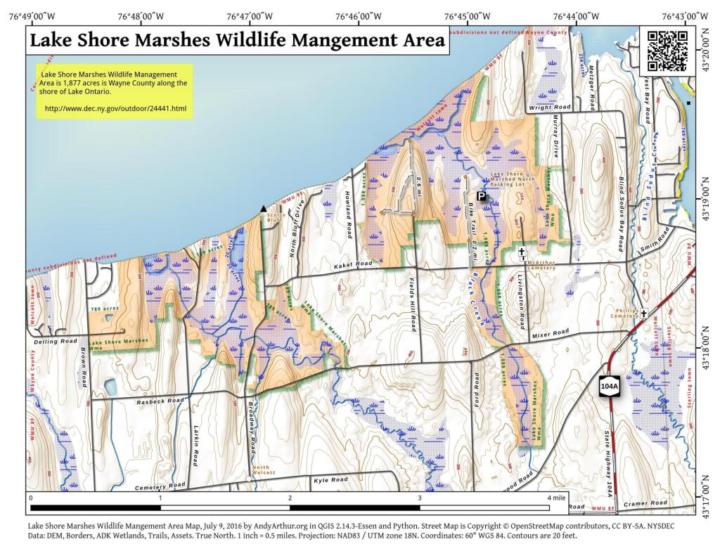
Map: Lake Shore Marshes Wildlife Mangement Area
Download a High Resolution JPEG Image of the Lake Shore Marshes Wildlife Mangement Area or an Adobe Acrobat Printable PDF of the Lake Shore Marshes Wildlife Mangement Area.

Bookmark my free Interactive GPS Map for your phone:
https://andyarthur.org/ny
... shows your location as a blue dot in relationship to campsites, trails, state land. This online map requires cell service, won't work in remote country, so also bring a paper map.
Free Download of New & Historical USGS 1:24k Topograpic Maps
Interactive maps with backcountry and roadside camping: New York, Pennsylvania, West Virginia & Vermont. List of NYS DEC Lean-Tos and Firetowers.
Google Spreadsheet with Roadside, Primitive and Pay Campsites
More about Lake Shore Marshes WMA...
The Lake Shore Marshes Wildlife Management Area is located between Rochester and Oswego in the northeastern part of Wayne County. This complex is composed of several units, is bounded on the north by. Lake Ontario and contains approximately 6,179 acres of wetlands and adjacent uplands.
Development has included the construction of small water impoundments and parking areas at scenic locations overlooking areas used by migrating waterfowl. Other developments consist of boat access sites and trails available to fishermen, hunters, hikers and naturalists.
The area offers a unique combination of lake-bay marsh environments providing varied habitats for many species of fish, mammals, songbirds, shorebirds and waterfowl. Management objectives emphasize waterfowl utilization of this area. Public recreational uses of a non-conflicting nature is encouraged. Black ducks, mallards, wood ducks and teal are the principal waterfowl species along with a variety of diving ducks on the open water areas.
Maps and Interactives
Lake Shore Marshes and the Plateau
Lake Shore Marshes Wildlife Mangement Area
... photos, maps and other content from from Lake Shore Marshes WMA.

1 Comment
Curious to know about hiking trails, if any, in this preserve.