The Big T – Campsites at Moose River Plains
Summer 2019 Aerial Photography.
Summer 2019 Aerial Photography.

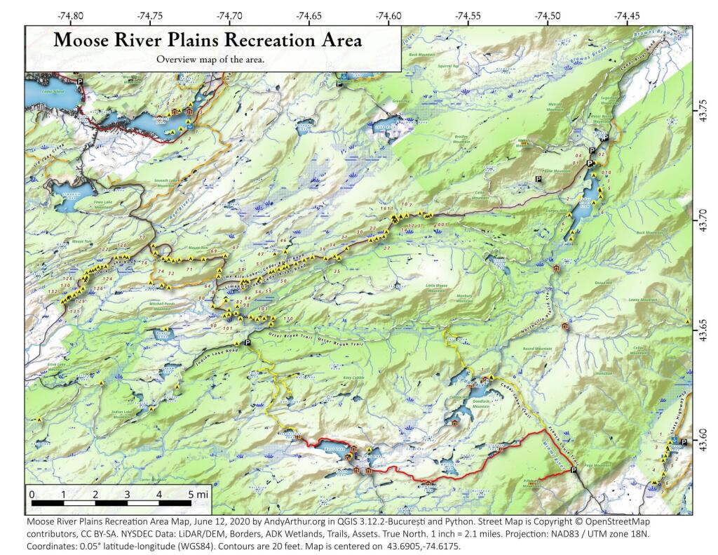
An overview map and list of campsites and their locations at the Moose River Recreation Area.
| Milepoint | Name | Feature | Notes | Access | Location | |||
|---|---|---|---|---|---|---|---|---|
| Cedar River Flow 1 | Cedar River Flow | Tent site on flow | Boat | 43.702924803151, -74.4871304116533 | ||||
| Cedar River Flow 2 | Cedar River Flow | Tent site on flow | Boat | 43.7104737708879, -74.4802343768254 | ||||
| Cedar River Flow 3 | Cedar River Flow | Tent site on flow | Boat | 43.7145237017622, -74.4679264444554 | ||||
| Cedar River Flow 5 | Cedar River Flow | Tent site on flow | Boat | 43.7111711590583, -74.4675178486588 | ||||
| Cedar River Flow 6 | Cedar River Flow | Tent site on flow | Boat | 43.7084767866376, -74.4717703157492 | ||||
| Beaver Lake Campsite | Beaver Lake | Site overlooks Beaver Lake | Hike | 43.6516613421651, -74.7407833400961 | ||||
| 81 | Icehouse Pond | Accessible site at Icehouse Pond with privy | Hike | 43.6646602166505, -74.7029502913239 | ||||
| 140A | Indian Lake | Campsite on Indian Lake, outhouse in bad condition | Hike | 43.6154753632731, -74.7499942080732 | ||||
| East of Muskrat Pond | Indian Lake Trail | Former roadside campsite, largely abandoned | Hike | 43.645116528704, -74.696221627206 | ||||
| 46 | Lost Ponds Trail | Beyond the end of current Lost Ponds Road | Hike | 43.6868179572109, -74.6655581886723 | ||||
| 47 | Lost Ponds Trail | Above Lost Ponds | Hike | 43.6859472953826, -74.6722052916864 | ||||
| Mitchell Pond 1 | Mitchell Pond | Tent site, bushwhack | Hike | 43.6729475881673, -74.7502538624373 | ||||
| Mitchell Pond 2 | Mitchell Pond | Tent site, bushwhack | Hike | 43.6716991892117, -74.7432124817486 | ||||
| 64A | Mitchell Pond (Accessible Campsite at End of Gravel Trail) | Gravel path to site, wildrness privy | Hike | 43.6706136251028, -74.7387363015355 | ||||
| 10 | 89 | Beaver Lake Road | Off Otter Brook Road, Sand Plains | Vehicle | 43.6583112347181, -74.7012491214803 | |||
| 11 | 90 | Beaver Lake Road | Off Otter Brook Road, Sand Plains | Vehicle | 43.6577446555162, -74.7038760912165 | |||
| 16 | 1 | Cedar River – Limekiln Lake Road | Driveway Along Tributary of Silver Run | Vehicle | 43.7033162602551, -74.5742148239156 | |||
| 16 | 3 | Cedar River – Limekiln Lake Road | Along Silver Run | Vehicle | 43.7027301523306, -74.5757742464803 | |||
| 16 | 4 | Cedar River – Limekiln Lake Road | Along Silver Run, driveway at Sharp S Turn | Vehicle | 43.7026421104662, -74.5769731929134 | |||
| 16 | 7 | Cedar River – Limekiln Lake Road | Along Silver Run | Vehicle | 43.7040070126376, -74.5809411044503 | |||
| 15 | 10 | Cedar River – Limekiln Lake Road | Old gravel pit, accessible | Vehicle | 43.7031498027862, -74.5893864145496 | |||
| 15 | 11 | Cedar River – Limekiln Lake Road | Across from 12 | Vehicle | 43.702458607149, -74.5926546451668 | |||
| 15 | 12 | Cedar River – Limekiln Lake Road | Across from 11 | Vehicle | 43.7028667147947, -74.5929833340894 | |||
| 15 | 13 | Cedar River – Limekiln Lake Road | Along Silver Run | Vehicle | 43.7010402113051, -74.5956355707995 | |||
| 15 | 14 | Cedar River – Limekiln Lake Road | Along Silver Run | Vehicle | 43.7010328498576, -74.597457469967 | |||
| 14 | 16 | Cedar River – Limekiln Lake Road | Access Road for 16/17/18 Group | Vehicle | 43.7025294616695, -74.5969885248639 | |||
| 14 | 17 | Cedar River – Limekiln Lake Road | Access Road for 16/17/18 Group | Vehicle | 43.7021028692463, -74.5966599329259 | |||
| 14 | 18 | Cedar River – Limekiln Lake Road | Access Road for 16/17/18 Group | Vehicle | 43.7023846304313, -74.5978818600647 | |||
| 14 | 19 | Cedar River – Limekiln Lake Road | Along Silver Run | Vehicle | 43.7003546491841, -74.5964872856253 | |||
| 14 | 21 | Cedar River – Limekiln Lake Road | Across road from Silver Run | Vehicle | 43.6957217888458, -74.6020563094081 | |||
| 13 | 22 | Cedar River – Limekiln Lake Road | Across road from Silver Run | Vehicle | 43.6935817523545, -74.6036764840587 | |||
| 13 | 27 | Cedar River – Limekiln Lake Road | Across road from Silver Run | Vehicle | 43.6926540634024, -74.6082201775478 | |||
| 13 | 30 | Cedar River – Limekiln Lake Road | Open Area in Woods | Vehicle | 43.6918525577623, -74.6118452191364 | |||
| 13 | 31 | Cedar River – Limekiln Lake Road | Near Marsh off Silver Run | Vehicle | 43.6881856235873, -74.6271629609656 | |||
| 12 | 34 | Cedar River – Limekiln Lake Road | Open Field Near Old Sly Pond Road | Vehicle | 43.6846954329325, -74.634678249126 | |||
| 12 | 35 | Cedar River – Limekiln Lake Road | Former Sly Pond Road | Vehicle | 43.6836690328942, -74.6318552827363 | |||
| 11 | 38 | Cedar River – Limekiln Lake Road | On Hill Overlooking Road, near start of Lost Ponds Area | Vehicle | 43.6836029270341, -74.6401393590772 | |||
| 11 | 39 | Cedar River – Limekiln Lake Road | Above CRLLR, start of Lost Ponds Area | Vehicle | 43.6841476346233, -74.6487511980121 | |||
| 11 | 40 | Cedar River – Limekiln Lake Road | Above CRLLR, start of Lost Ponds Area | Vehicle | 43.682942162164, -74.6537793571789 | |||
| 11 | 41 | Cedar River – Limekiln Lake Road | Above CRLLR, start of Lost Ponds Area | Vehicle | 43.681311345096, -74.6589116717693 | |||
| 10 | 42 | Cedar River – Limekiln Lake Road | Above CRLLR, start of Lost Ponds Area | Vehicle | 43.6799039050817, -74.6646031695507 | |||
| 10 | 43 | Cedar River – Limekiln Lake Road | Above CRLLR, start of Lost Ponds Area | Vehicle | 43.6793727911294, -74.6664156654099 | |||
| 10 | 44 | Cedar River – Limekiln Lake Road | West of Lost Ponds Road, Sand Plains | Vehicle | 43.678808787762, -74.6696555368193 | |||
| 10 | 50 | Cedar River – Limekiln Lake Road | West of Lost Ponds Road, Sand Plains | Vehicle | 43.677986610504, -74.6732025802129 | |||
| 10 | 51 | Cedar River – Limekiln Lake Road | Pull-Off, Small Site, Sand Plains | Vehicle | 43.6775108499728, -74.6750146421403 | |||
| 10 | 52 | Cedar River – Limekiln Lake Road | Old gravel pit, short loop below CRLLR | Vehicle | 43.6748840847288, -74.6815273754233 | |||
| 10 | 53 | Cedar River – Limekiln Lake Road | Access Road for 55/54/55 Group, Sand Plains | Vehicle | 43.6733317629897, -74.6820452615144 | |||
| 10 | 54 | Cedar River – Limekiln Lake Road | Access Road for 55/54/55 Group, Sand Plains | Vehicle | 43.673268538603, -74.6822820352903 | |||
| 9 | 55 | Cedar River – Limekiln Lake Road | Access Road for 55/54/55 Group, Sand Plains | Vehicle | 43.6733705968856, -74.6827076379887 | |||
| 9 | 56 | Cedar River – Limekiln Lake Road | Driveway, East of Former Dump, Sand Plains | Vehicle | 43.673126585883, -74.6891475571674 | |||
| 9 | 57 | Cedar River – Limekiln Lake Road | Has Trail to Moose River | Vehicle | 43.6736673106707, -74.6902687046523 | |||
| 8 | 64 | Cedar River – Limekiln Lake Road | Near Mitchell Pond Trail | Vehicle | 43.6757521870177, -74.707500815672 | |||
| 8 | 66 | Cedar River – Limekiln Lake Road | Near Pine Creek | Vehicle | 43.6784203854214, -74.7068492021325 | |||
| 7 | 67 | Cedar River – Limekiln Lake Road | Benedict Creek Road, Wooded | Vehicle | 43.6851041444828, -74.7031887110586 | |||
| 7 | 69 | Cedar River – Limekiln Lake Road | Remote site, perched over the road | Vehicle | 43.6834516958835, -74.7168906980223 | |||
| 6 | 70 | Cedar River – Limekiln Lake Road | Large loop off of CRLLR | Vehicle | 43.6839906014562, -74.7249870178447 | |||
| 6 | 71 | Cedar River – Limekiln Lake Road | Very sandy site near Mitchells Pond Upper Loop | Vehicle | 43.6833776353921, -74.7321947941391 | |||
| 5 | 72 | Cedar River – Limekiln Lake Road | At end of Bear Pond Loop Road (Accessable) | Vehicle | 43.6828956047277, -74.7359084701559 | |||
| 4 | 73 | Cedar River – Limekiln Lake Road | Very sandy site near Mitchells Pond Upper Loop | Vehicle | 43.6835777053685, -74.7387188889593 | |||
| 4 | 74 | Cedar River – Limekiln Lake Road | On a hill overlooking road and marshy area | Vehicle | 43.6839187521201, -74.742285779317 | |||
| 4 | 76 | Cedar River – Limekiln Lake Road | Very sandy site near Mitchells Pond Upper Loop | Vehicle | 43.6864452702399, -74.7471689344191 | |||
| 4 | 77 | Cedar River – Limekiln Lake Road | Near Red River, Bear Pond Loop, Sand Plains | Vehicle | 43.6897961458669, -74.7484803840413 | |||
| 10 | 58 | Helldiver Pond Road | Near Helldiver Pond | Vehicle | 43.6735979105991, -74.6920316000423 | |||
| 10 | 59 | Helldiver Pond Road | Near Helldiver Pond | Vehicle | 43.6723766419894, -74.6929318681131 | |||
| 10 | 60 | Helldiver Pond Road | Near Helldiver Pond | Vehicle | 43.6713193532923, -74.692758456613 | |||
| 10 | 61 | Helldiver Pond Road | Accessible site at end of Helldiver Pond Road | Vehicle | 43.6705019900204, -74.6921751440693 | |||
| 15 | West of Brooktrout Trail | Indian Lake Road | Past Brooktrout Trail, on a hill over road | Vehicle | 43.6254538914434, -74.7337300739322 | |||
| 10 | 48 | Lost Pond Road | Sand Plains, Marshes Aroubnd | Vehicle | 43.6814268347573, -74.6667101324338 | |||
| 11 | 49 | Lost Pond Road | Sand Plains, Marshes Aroubnd | Vehicle | 43.6819456385478, -74.6670131106595 | |||
| 10 | 80 | Otter Brook Road | Has Trail to Moose River | Vehicle | 43.6620917920003, -74.7112181918076 | |||
| 11 | 98 | Otter Brook Road | Above Moose River on Hill | Vehicle | 43.6588725644731, -74.6966603409996 | |||
| 11 | 101 | Otter Brook Road | Sand Plains | Vehicle | 43.6564420559443, -74.6938956128147 | |||
| 11 | 103 | Otter Brook Road | Sand Plains | Vehicle | 43.657108724794, -74.6873446316172 | |||
| 12 | 104 | Otter Brook Road | Wooded Site | Vehicle | 43.6560617426567, -74.6832992891923 | |||
| 12 | 106 | Otter Brook Road | Wooded Site | Vehicle | 43.6565121581975, -74.6789913497265 | |||
| 13 | 110 | Otter Brook Road | Wooded Site | Vehicle | 43.6566072628101, -74.6733859460379 | |||
| 13 | 111 | Otter Brook Road | Near Otter Brook Bridge | Vehicle | 43.6539235327721, -74.6747718892435 | |||
| 23 | 1 | Wakely Dam Camping Area | Accessible site | Vehicle (before gate) | 43.7266767212397, -74.474100266424 | |||
| 23 | 2 | Wakely Dam Camping Area | Field Camping | Vehicle (before gate) | 43.7266515010084, -74.4733110730078 | |||
| 23 | 3 | Wakely Dam Camping Area | Field Camping | Vehicle (before gate) | 43.7259595122959, -74.473899965642 | |||
| 23 | 4 | Wakely Dam Camping Area | On Driveway to Lake | Vehicle (before gate) | 43.7260676922081, -74.4742326471903 | |||
| 23 | 5 | Wakely Dam Camping Area | On Driveway to Lake | Vehicle (before gate) | 43.7255637908987, -74.4741751228291 | |||
| 23 | 6 | Wakely Dam Camping Area | On Driveway to Lake | Vehicle (before gate) | 43.7252231337487, -74.4745830371916 | |||
| 23 | 9 | Wakely Dam Camping Area | Across bridge | Vehicle (before gate) | 43.726275356142, -74.4717840349063 | |||
| 23 | 10 | Wakely Dam Camping Area | Across bridge | Vehicle (before gate) | 43.7266308152758, -74.4712600272389 | |||
| 10 | 82 | Otter Brook Road | On Moose River | Vehicle (driveway) | 43.6603083771227, -74.7010353925305 | |||
| 11 | 84 | Otter Brook Road | On Moose River | Vehicle (driveway) | 43.6619962517853, -74.6957783254417 | |||
| 6 | 120 | Natural Rock Dam Road | Sand Plains near Red River | Vehicle (Opens July) | 43.6848543033273, -74.7664253595203 | |||
| 6 | 122 | Natural Rock Dam Road | Wooded Site | Vehicle (Opens July) | 43.684367353989, -74.7717171949716 | |||
| 6 | 123 | Natural Rock Dam Road | Wooded Site | Vehicle (Opens July) | 43.6804228755091, -74.7782951743141 | |||
| 6 | 124 | Natural Rock Dam Road | Wooded Site | Vehicle (Opens July) | 43.6792030487765, -74.7847972548314 | |||
| 7 | 125 | Natural Rock Dam Road | Wooded Site | Vehicle (Opens July) | 43.6783559964111, -74.7880327043169 | |||
| 7 | 126 | Natural Rock Dam Road | Wooded Site | Vehicle (Opens July) | 43.6748535298235, -74.790591643043 | |||
| 7 | 127 | Natural Rock Dam Road | Wooded Site | Vehicle (Opens July) | 43.6739776362472, -74.7910844137006 | |||
| 7 | 128 | Natural Rock Dam Road | Wooded Site | Vehicle (Opens July) | 43.6751413481917, -74.7924842843025 | |||
| 8 | 129 | Natural Rock Dam Road | Wooded Site | Vehicle (Opens July) | 43.6703784784539, -74.7926312803463 | |||
| 8 | 130 | Natural Rock Dam Road | Wooded Site | Vehicle (Opens July) | 43.6666270858056, -74.8019151989726 | |||
| 8 | 131 | Natural Rock Dam Road | Wooded Site | Vehicle (Opens July) | 43.6643581634434, -74.8054154753831 | |||
| 8 | 132 | Natural Rock Dam Road | Wooded Site | Vehicle (Opens July) | 43.6652083016168, -74.8036826184027 | |||
| 5 | 119A | Natural Rock Dam Road | Sand Plains near Red River | Vehicle (Opens July) | 43.6844716021433, -74.7646961785253 | |||
| 6 | 123A | Natural Rock Dam Road | Wooded Site | Vehicle (Opens July) | 43.6802422604152, -74.782965042166 | |||
| 6 | 124A | Natural Rock Dam Road | Wooded Site | Vehicle (Opens July) | 43.6785899888224, -74.7864319884685 | |||
| 6 | 125A | Natural Rock Dam Road | Wooded Site | Vehicle (Opens July) | 43.6776017274889, -74.7902229325712 | |||
| 7 | 126A | Natural Rock Dam Road | Wooded Site | Vehicle (Opens July) | 43.6756110574941, -74.7901645681643 | |||
| 8 | 129A | Natural Rock Dam Road | Wooded Site | Vehicle (Opens July) | 43.6689370211979, -74.7948887917477 | |||
| 8 | 129AA | Natural Rock Dam Road | Wooded Site | Vehicle (Opens July) | 43.6674497436753, -74.7980604042935 | |||
| 8 | 130A | Natural Rock Dam Road | Wooded Site | Vehicle (Opens July) | 43.6661052974262, -74.8016557609016 | |||
| 8 | 130AA | Natural Rock Dam Road | Wooded Site | Vehicle (Opens July) | 43.6669094078356, -74.8007390664074 |


This Google Map shows most of the designated campsites at Moose River Plains. You can also download the KML from the right side of this page. For more interactive maps and data to download for your GPS, please see the Google County Maps section of my blog: https://andyarthur.org/google-county-maps
Overlaid with contemporary location of campsites and trails at Moose River Plains.

Overview map of Moose River Plains. This shows the location of the campsites and major trails throughout the area. I probably could improve on this map, but I think this does give on a good overview that can be easily printed on an 8x11" sheet of paper.


Link to an Interactive Map of the Northville Placid Trail.
| Type | Name | Description | Coordinates |
| Hand Launch | Ceder River Flow Boat Ramp | Hand Carry Launch, Ramp | 43.725826369700904, -74.47289916126694 |
| Lean-To | Beaver Pond (Aka Cedar Lakes Lean-To #2) | 43.625969396804386, -74.54927150370021 | |
| Lean-To | Carry Lean-To | 43.67874488347091, -74.49549821879448 | |
| Lean-To | Catlin Bay #1 Lean-To | 43.99801269269887, -74.39278456108421 | |
| Lean-To | Cedar Lakes #1 Lean-To | 43.628125665037935, -74.54047323992656 | |
| Lean-To | Cold River #2 Lean-To | 44.14251664317184, -74.13035824291548 | |
| Lean-To | Cold River #3 Lean-To | 44.091459278051204, -74.25764175084498 | |
| Lean-To | Cold River #4 Lean-To | 44.09139025333258, -74.25573480252505 | |
| Lean-To | Cold River Lean-To #1 Lean-To | 44.14272737628489, -74.12984021065587 | |
| Lean-To | Duck Hole #1 Lean-To | 44.14162687400988, -74.10693734676616 | |
| Lean-To | Duck Hole #2 Lean-To | 44.14167686466829, -74.10654354672256 | |
| Lean-To | Hamilton Lake Stream #1 Lean-To | 43.39741359517532, -74.45529759002217 | |
| Lean-To | Hidden Cove Lean-To | 44.00265528819394, -74.38648026325164 | |
| Lean-To | Kelly Point #1 Lean-To | 44.02880023617087, -74.36730798599064 | |
| Lean-To | Kelly Point #2 Lean-To | 44.02870256717196, -74.36713034867948 | |
| Lean-To | Moose Pond Lean-To | 44.182843382402666, -74.07364102375995 | |
| Lean-To | Mud Lake Lean-To | 43.342671073157994, -74.45629078563864 | |
| Lean-To | O’neill Flow Lean-To | 43.875596840936154, -74.36642623697053 | |
| Lean-To | Ouluska Pass Brook Lean-To | 44.120221281603584, -74.18744717390932 | |
| Lean-To | Plumley Point #2 Lean-To | 44.06559891610762, -74.32761224546002 | |
| Lean-To | Rodney Point #1 Lean-To | 44.04140938489936, -74.35014909639557 | |
| Lean-To | Rodney Point #2 Lean-To | 44.042976745412616, -74.34933464753136 | |
| Lean-To | Seward Lean-To | 44.106244137686204, -74.2091536427719 | |
| Lean-To | Silver Lake Lean-To | 43.29193545679836, -74.4237351676776 | |
| Lean-To | South Lake Lean-To | 43.58724480971, -74.62157883837274 | |
| Lean-To | Spruce Lake #1 Lean-To | 43.52728411257782, -74.6099246975027 | |
| Lean-To | Spruce Lake #2 Lean-To | 43.53463062983387, -74.60808580306896 | |
| Lean-To | Spruce Lake #3 Lean-To | 43.53712972792447, -74.60820962802477 | |
| Lean-To | Stephens Pond Lean-To | 43.818673668554965, -74.42052487172707 | |
| Lean-To | Tirrel Pond North Lean-To | 43.887344477557306, -74.37880062606054 | |
| Lean-To | West Canada Creek Lean-To | 43.58698761405157, -74.61399797100106 | |
| Lean-To | West Lake #1 Lean-To | 43.59316222884976, -74.62688668431306 | |
| Lean-To | West Stony Creek Lean-To | 43.22474428954461, -74.26933345717664 | |
| Paved Parking Lot | Lake Durant Northville Placid Trail Parking Lot | Paved, 12 Vehicle Capacity | 43.84219550506574, -74.3862742856788 |
| Paved Parking Lot | Northville Lake Placid Trail Parking Lot | Paved, Good Condition | 43.84213270187873, -74.38656792328511 |
| Primitive Tent Site | Canary Pond Campsite | 43.30513256312245, -74.4472062440692 | |
| Primitive Tent Site | Cedar Lake Dam 1 | 43.62894580965635, -74.53639939387939 | |
| Primitive Tent Site | Cedar Lake Dam Tentsite | 43.62937624507422, -74.53679785644344 | |
| Primitive Tent Site | Cedar River Flow Tentsite | 43.70292480315104, -74.48713041165333 | |
| Primitive Tent Site | Fall Stream Tentsites | 43.49661052800474, -74.53713112743992 | |
| Primitive Tent Site | Jessup River Tentsites | 43.51246207852797, -74.57229710138834 | |
| Primitive Tent Site | Kelly Point Tentsites | 44.02910364406153, -74.36670207204214 | |
| Primitive Tent Site | Moose Pond Tentsites | 44.18274441156179, -74.07408240028583 | |
| Primitive Tent Site | Moose River Plains Campsite 01 | Live | 43.72667672123972, -74.47410026642402 |
| Primitive Tent Site | Moose River Plains Campsite 02 | Live | 43.72665150100841, -74.47331107300782 |
| Primitive Tent Site | Moose River Plains Campsite 03 | Live | 43.725959512295866, -74.47389996564202 |
| Primitive Tent Site | Moose River Plains Campsite 04 | Live | 43.726067692208126, -74.47423264719026 |
| Primitive Tent Site | Moose River Plains Campsite 05 | Live | 43.725563790898704, -74.47417512282912 |
| Primitive Tent Site | Moose River Plains Campsite 06 | Live | 43.72522313374867, -74.47458303719159 |
| Primitive Tent Site | Mud Lake Tentsites | 43.59647433847274, -74.61354076182431 | |
| Primitive Tent Site | O’neill Flow Tentsite | 43.87567135918534, -74.3666467203306 | |
| Primitive Tent Site | Rock Lake Campsite | 43.265591839994535, -74.41543516012669 | |
| Primitive Tent Site | Salmon River Tentsites | 43.907925071619914, -74.38530801916977 | |
| Primitive Tent Site | Shattuck Clearing Tentsites | 44.08679657756681, -74.26368397541134 | |
| Primitive Tent Site | Silver Lake Tent Site | 43.29112770008321, -74.4240469986026 | |
| Primitive Tent Site | Spruce Lake Tentsite | 43.53695545329776, -74.60818912022354 | |
| Primitive Tent Site | Tirrell Pond North Tentsites | 43.88594343639596, -74.37834897628142 | |
| Primitive Tent Site | Trailside Campsite | 43.2716741112023, -74.43107546264162 | |
| Primitive Tent Site | Wanika Falls Tentsites | 44.19944690357389, -74.05663862305364 | |
| Primitive Tent Site | West Lake Former Caretaker Clearing Tentsites | 43.59389874347195, -74.62560220247346 | |
| Primitive Tent Site | Whitehouse Campsite | 43.373430193527696, -74.43578942968477 | |
| Primitive Tent Site | Whitehouse Campsite | 43.37406302094423, -74.43516794694158 | |
| Primitive Tent Site | Woods Lake Campsite #2 | Fire Pit, Water Front Campsite | 43.25071034607129, -74.31177480398298 |
| Primitive Tent Site | Woods Lake Campsite #3 | Fire Ring, Water Front Tentsite, Scenic View | 43.250888826581715, -74.31104030228295 |
| Primitive Tent Site | Woods Lake Campsite #4 | Fire Place, Water Front Campsite, Nice View | 43.251811433787196, -74.3092782205918 |
| Unpaved Parking Lot | Benson Road Parking Area | 8 Vehicle Capacity | 43.24745928673895, -74.31187044250609 |
| Unpaved Parking Lot | Chubb River Bridge | 44.2628824981147, -74.01364844250504 | |
| Unpaved Parking Lot | Moose River Recrieation Area | Northville-Placid And Cedar River Trails | 43.726457025366315, -74.47386984656715 |
| Unpaved Parking Lot | Norhtville Placid Parking-Haskells Rd | 43.45841038153893, -74.52201705350714 | |
| Unpaved Parking Lot | Northville Placid Trail Parking Area | 6 Car Interior Parking Area | 43.21330828950083, -74.2083824784703 |
| Unpaved Parking Lot | Northville Placid Trail Route 28n Parking Lot | 43.97584466308438, -74.39296138679799 | |
| Unpaved Parking Lot | Tarbell Road Shoulder Parking Lot | 43.984346733793245, -74.39813014848872 | |
| Unpaved Parking Lot | Wakely Dam | 43.72640808237045, -74.47425964611213 | |
| Unpaved Parking Lot | Wakely Mountain Trailhead Parking Lot | 1250 Sq Feet | 43.732197733217824, -74.47253968128065 |
| Unpaved Parking Lot | Wakely Pond Accessible Fishing Dock | 43.737643556916666, -74.46542853470272 | |
| Unpaved Parking Lot | Wakely Pond Accessible Launch | 43.738042554833534, -74.46399313053813 |


A series of topographic maps showing campsites and popular destinations at Moose River Plains.
Notifications