Sugar Hill State Forest Campsite Coordinates 🏕 🐎
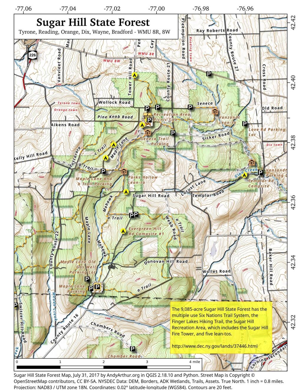
Explore this webpage for comprehensive maps and campsite listings within Sugar Hill State Forest, situated in the Finger Lakes region near Watkins Glen. Renowned for its equestrian trails and mountain biking possibilities, this forest also intersects with the Finger Lakes Trails.
Equipped with coordinates and interactive maps, this invaluable resource assists in pinpointing free camping sites within this area. Uncover more about the region to enhance your exploration, ensuring a memorable experience amid its natural beauty. From the allure of equestrian trails to the thrill of mountain biking routes and the Finger Lakes Trails, Sugar Hill State Forest offers a diverse range of outdoor activities for all to enjoy.
Free campsites are available for stays of up to 3 nights. Simply register on-site by signing the log book. For longer stays of 4 to 14 nights, contact the DEC Region 8 Bath Office during their operating hours (M-F, 8:30 AM – 4:30 PM) at (607) 622-8282 or region8@dec.ny.gov to request a free permit.
Here are the coordinates to the campsites.
| Name | Description | Notes | Latitude | Longitude |
| 1 Tower Area Campsite | #1 | 42.3868508079723 | -77.0033564547783 | |
| 2 Tower Area Campsite | #2 | 42.3866442287727 | -77.0033822152506 | |
| 3 Tower Area Campsite | #3 | 42.3864639920396 | -77.0033635495228 | |
| 4 Tower Area Campsite | #4 | 42.3862833428498 | -77.0033685808509 | |
| 6 Tower Area Campsite | #6 | 42.386387348997 | -77.0029946864047 | |
| 7 Tower Area Campsite | #7 | Water Spigot | 42.3862370801033 | -77.0029985287376 |
| 8 Tower Area Campsite | #8 | 42.3861734193137 | -77.003166784239 | |
| 9 Tower Area Campsite | #9 | 42.3865302803854 | -77.0027707543571 | |
| 10 Tower Area Campsite | #10 | 42.3861779212511 | -77.0028177471854 | |
| 11 Tower Area Campsite | #11 | 42.3864896808166 | -77.0025428626279 | |
| 12 Tower Area Campsite | #12 | 42.386122136377 | -77.0026163066674 | |
| 13 Tower Area Campsite | #13 | 42.3865438057378 | -77.0022831123144 | |
| 14 Tower Area Campsite | #14 | 42.386195258838 | -77.0023742768928 | |
| 15 Tower Area Campsite | #15 | 42.3860849947623 | -77.0021918714237 | |
| 16 Tower Area Campsite | #16 | 42.3860541128779 | -77.0019473250332 | |
| 17 Tower Area Campsite | #17 | 42.3860671182971 | -77.0017515936378 | |
| 18 Tower Area Campsite | #18 | Water Spigot | 42.386226464603 | -77.0016855292304 |
| 19 Tower Area Campsite | #19 | Water Spigot | 42.3865569715304 | -77.0017003446791 |
| 20 Tower Area Campsite | #20 | Water Spigot | 42.3866767087554 | -77.0017063052538 |
| 21 Tower Area Campsite | #21 | Water Spigot | 42.3869433342594 | -77.0017190894415 |
| 22 Tower Area Campsite | #22 | 42.3868316308635 | -77.0011615867452 | |
| 23 Tower Area Campsite | #23 | 42.3865865191587 | -77.001106379471 | |
| 24 Tower Area Campsite | #24 | 42.3863193084256 | -77.0012185947968 | |
| 25 Tower Area Campsite | #25 | 42.3861742601053 | -77.0012894260423 | |
| 26 Tower Area Campsite | #26 | 42.3860963967437 | -77.0015391367911 | |
| 27 Tower Hill Cmpsite | #27 | 42.3907655427657 | -76.9988721092714 | |
| 28 Tower Hill Rd Campsite | #28 | 42.3910797321534 | -76.9837920975243 | |
| 29 Cr 23 Campsite | #29 | 42.4023570878519 | -76.9758496629551 | |
| 30 Tower Hill Rd Campsite | #30 | 42.3902721886657 | -77.0028807356518 | |
| 31 Tower Hill Rd Campsite | #31 | 42.3904413584792 | -77.0036125118773 | |
| 32 Seneca North Campsite | #32 | 42.3847576397127 | -77.0052625526894 | |
| 33 Maple Lane Campsite | #33 | 42.3779066686613 | -77.0179033333715 | |
| 34 Maple Lane Campsite | #34 | 42.3734853366746 | -77.0214073314773 | |
| 35 Maple Lane Campsite | #35 | 42.3690875961503 | -77.0223501994882 | |
| 36 Sugar Hill Road Campsite | #36 | 42.3623013335723 | -77.0118293336207 | |
| 37 Spencer Pond Campsite | #37 | 42.4016911747852 | -77.0084235506782 | |
| 38 Evergreen Hill Road Campsite | #38 | 42.3547490565555 | -77.0073917279777 | |
| Cr 21 Campsite | 42.3843480264464 | -76.9922894964248 | ||
| Evergreen Hill Rd Campsite #1 | 42.3491716695934 | -77.0127316661659 | ||
| Lower Evergreen Camping | 42.3304466927625 | -77.0236097240433 | ||
| Randall Road Campsite | Log Landing | 42.3412383335045 | -77.0695449989935 | |
| Switzer Hill Road Campsite #2 | Log Landing | 42.3406636026594 | -77.0649210396798 | |
| Templar Rd Campsite | 42.3688377042101 | -76.9587191825894 |