| Name |
Road |
State Forest |
Location |
| Flt Lean To |
Bryant Hill Road |
Boyce Hill State Forest |
42.334031456350395, -78.53288931105153 |
| Primitive Campsite |
Bryant Hill Road |
Boyce Hill State Forest |
42.33203561607121, -78.52072510644783 |
| Primitive Campsite |
Fadale Road |
Bryant Hill State Forest |
42.287766301177825, -78.5774157216985 |
| Primitive Campsite |
West Branch Bucktooth Run Road |
Bucktooth State Forest |
42.205385216534836, -78.80556091590128 |
| Designated Camp Site |
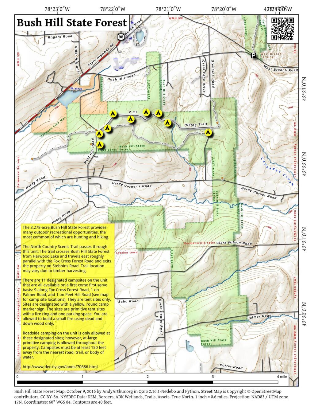
Bush Hill State Forest Road |
Bush Hill State Forest |
42.37521134312278, -78.3723830068076 |
| Designated Camp Site |
Bush Hill State Forest Road |
Bush Hill State Forest |
42.375432685587, -78.37003424588094 |
| Designated Camp Site |
Bush Hill State Forest Road |
Bush Hill State Forest |
42.37844883545774, -78.36321615357782 |
| Designated Camp Site |
Bush Hill State Forest Road |
Bush Hill State Forest |
42.37834161197144, -78.3603878146659 |
| Designated Camp Site |
Bush Hill State Forest Road |
Bush Hill State Forest |
42.378704575994334, -78.35968870249168 |
| Designated Camp Site |
Palmer Road |
Bush Hill State Forest |
42.332735974553664, -78.33508401120383 |
| Designated Camp Site |
Peet Hill Road |
Bush Hill State Forest |
42.37229363838375, -78.37197015797723 |
| Designated Camp Site |
State Highway 98 |
Bush Hill State Forest |
42.378694393114884, -78.36651378010052 |
| Designated Camp Site |
State Highway 98 |
Bush Hill State Forest |
42.378944741693765, -78.35539058173165 |
| Designated Camp Site |
Stebbins Road |
Bush Hill State Forest |
42.37513245260474, -78.33871444372613 |
| Primitive Campsite |
Toad Hollow Road |
Cattaraugus State Forest |
42.323838469029404, -78.81981283576603 |
| Primitive Campsite |
West Hill Road |
Cattaraugus State Forest |
42.325245350697024, -78.82172344496075 |
| Primitive Campsite |
West Hill Road |
Cattaraugus State Forest |
42.32545276366107, -78.82246616963481 |
| Primitive Campsite |
Bedient Hill Road |
Dobbins Memorial State Forest |
42.28567958355708, -78.78343174073662 |
| Primitive Campsite |
Bedient Hill Road |
Dobbins Memorial State Forest |
42.2858770172506, -78.78182441930888 |
| Primitive Campsite |
Kahler Hill Road |
Dobbins Memorial State Forest |
42.2823609209492, -78.78908764990703 |
| Campsite 1 |
East Otto Forest Access Road |
East Otto State Forest |
42.42956020071717, -78.77841498639349 |
| Campsite 10 |
East Otto Forest Access Road |
East Otto State Forest |
42.436794682289374, -78.78725605998474 |
| Campsite 11 |
East Otto Forest Access Road |
East Otto State Forest |
42.43686641131175, -78.78876182516233 |
| Campsite 12 |
East Otto Forest Access Road |
East Otto State Forest |
42.439942456335444, -78.79280632243916 |
| Campsite 13 Off Road |
East Otto Forest Access Road |
East Otto State Forest |
42.44116228532883, -78.7935142352489 |
| Campsite 2 |
East Otto Forest Access Road |
East Otto State Forest |
42.43075196187435, -78.77829192648777 |
| Campsite 3 |
East Otto Forest Access Road |
East Otto State Forest |
42.431524557985085, -78.77807270060917 |
| Campsite 4 |
East Otto Forest Access Road |
East Otto State Forest |
42.43246812683191, -78.77812945302628 |
| Campsite 5 |
East Otto Forest Access Road |
East Otto State Forest |
42.43354865333, -78.77826528183961 |
| Campsite 6 |
East Otto Forest Access Road |
East Otto State Forest |
42.435748272602346, -78.78009578405866 |
| Campsite 7 |
East Otto Forest Access Road |
East Otto State Forest |
42.437766021114236, -78.78129798391932 |
| Campsite 8 |
East Otto Forest Access Road |
East Otto State Forest |
42.438307230216544, -78.78167796579675 |
| Campsite 9 |
East Otto Forest Access Road |
East Otto State Forest |
42.43658224437387, -78.78115339512692 |
| Off Rd Campsite 14 |
Campsite Trail |
East Otto State Forest |
42.43495753137711, -78.78631225057045 |
| Designated Camping Site |
Finger Lakes / North Country Trail |
Farmersville State Forest |
42.395559234340155, -78.32385801814708 |
| Primitive Campsite |
Huyck Road |
Farmersville State Forest |
42.40195676450733, -78.32651113957189 |
| Designated Camp Site |
Humphrey Road |
Golden Hill State Forest |
42.24476227074854, -78.53567581233197 |
| Designated Camp Site |
Humphrey Road |
Golden Hill State Forest |
42.22838609079557, -78.55140114891826 |
| Designated Camp Site |
Salamanca Sugertown |
Golden Hill State Forest |
42.25727682111409, -78.52462511082716 |
| Designated Camp Site |
Salamanca Sugertown |
Golden Hill State Forest |
42.252966372418044, -78.52422796002587 |
| 8 Ccc Cross Pfar |
Mc Carthy Hill Road |
Mccarty Hill State Forest |
42.24536126968311, -78.70056799396085 |
| 9 Ccc Cross Pfar |
Mc Carthy Hill Road |
Mccarty Hill State Forest |
42.25008232988369, -78.69743897194299 |
| Designated Campsite |
Mc Carthy Hill Road |
Mccarty Hill State Forest |
42.25328568563576, -78.69299839361288 |
| Broadwide Landing |
|
Mccarty Hill State Forest |
42.24170279920399, -78.68606010543651 |
| Designated Camp Site |
North Nine Mile Road |
Nine Mile Creek State Forest |
42.15299393539406, -78.54523009763237 |
| Designated Camp Site |
North Nine Mile Road |
Nine Mile Creek State Forest |
42.13609995741345, -78.56646823383102 |
| Designated Camp Site |
|
Nine Mile Creek State Forest |
42.16580689557993, -78.56330674730353 |
| Designated Camping Site |
Carr Corners Road |
Pine Hill State Forest |
42.0902198677204, -78.97720883047309 |
| Designated Camping Site |
Carr Corners Road |
Pine Hill State Forest |
42.08987421564301, -78.97718113243893 |
| Designated Camping Site |
Carr Corners Road |
Pine Hill State Forest |
42.088972084193635, -78.96827770846221 |
| Designated Camping Site |
Carr Corners Road |
Pine Hill State Forest |
42.08999766571543, -78.97714470943136 |
| Designated Camping Site |
Carr Corners Road |
Pine Hill State Forest |
42.089992105140524, -78.97802317468417 |
| Designated Camping Site |
Carr Corners Road |
Pine Hill State Forest |
42.088316667983676, -78.97750870331804 |
| Designated Camping Site |
Sarver Road |
Pine Hill State Forest |
42.09084333446055, -78.96457500076367 |
| Designated Camping Site |
West Bank Perimeter Road |
Pine Hill State Forest |
42.09059447216186, -78.9782701169741 |
| Designated Camping Site |
West Bank Perimeter Road |
Pine Hill State Forest |
42.090410597678044, -78.97737141838545 |
| Designated Camping Site |
West Bank Perimeter Road |
Pine Hill State Forest |
42.09070243921129, -78.97767425198705 |
| Designated Camping Site |
West Bank Perimeter Road |
Pine Hill State Forest |
42.09055923398494, -78.97748952634339 |
| Designated Camping Site |
West Bank Perimeter Road |
Pine Hill State Forest |
42.088333001084294, -78.96315816701363 |
| Designated Camp Site |
Raecher Road |
Raecher Hill State Forest |
42.21543142820224, -78.59833921002581 |
| Designated Camp Site |
Salamanca Sugertown |
Raecher Hill State Forest |
42.2239162845665, -78.58440803241541 |
| 6 Eckert Pfar |
Eckert Road |
Rock City State Forest |
42.21386553760053, -78.72868667109137 |
| 1 Pavilion |
Hungry Hollow Road |
Rock City State Forest |
42.20887482379478, -78.71081750896558 |
| 10 Hale Pfar |
Hungry Hollow Road |
Rock City State Forest |
42.210726592762555, -78.70083869524316 |
| 2 Camp Seneca |
Hungry Hollow Road |
Rock City State Forest |
42.22426854552666, -78.70039460166258 |
| 2 Pavilion |
Hungry Hollow Road |
Rock City State Forest |
42.20874441897034, -78.70925235825437 |
| 5 Little Rock City Pfar |
Hungry Hollow Road |
Rock City State Forest |
42.21356536202227, -78.71471680281755 |
| 7 Camp Seneca |
Hungry Hollow Road |
Rock City State Forest |
42.224419413504464, -78.6988716555344 |
| 1 Camp Seneca |
|
Rock City State Forest |
42.22472181689035, -78.6999719301751 |
| 3 Camp Seneca |
|
Rock City State Forest |
42.22443219662994, -78.69949145115731 |
| 3 Pavilion |
|
Rock City State Forest |
42.20829863384421, -78.70878335178874 |
| 4 Pavilion |
|
Rock City State Forest |
42.207897403667076, -78.70778549612025 |
| Sawmill Campsite |
Sawmill Run Road |
South Valley State Forest |
42.0412038345878, -79.00831666649613 |
| Phillips Brook Campsite |
West Bank Perimeter Road |
South Valley State Forest |
42.067833333551825, -78.98651616744397 |
| Phillips Brook Campsite |
West Bank Perimeter Road |
South Valley State Forest |
42.067053833805446, -78.98539216695083 |
| Primitive Campsite |
West Bank Perimeter Road |
South Valley State Forest |
42.06781668899903, -78.986579480953 |
| Primitive Campsite |
West Bank Perimeter Road |
South Valley State Forest |
42.066675066943084, -78.98465915701098 |
| Designated Camp Site |
Thorpe Hollow Road |
Windfall Creek State Forest |
42.143916972753914, -78.61946242159415 |
| Designated Camp Site |
Thorpe Hollow Road |
Windfall Creek State Forest |
42.13859287926947, -78.63237608867878 |
| Designated Camp Site |
|
Windfall Creek State Forest |
42.11866864256446, -78.63172401550162 |
