The east end of this expressway (right) is located in the Westvale neighborhood of the Town of Geddes. The expressway was planned to continue across West Genesee Street as a southwestern bypass of Syracuse, and would have connected with the junction of Interstates 81 and 481 in southern Syracuse. A spur from this beltway would have carried NY 5 into the downtown district. Today, the expressway stub shows a partially-built folded diamond interchange (with a loop in the northeast quadrant), where today NY 5 turns east onto West Genesee Street towards Solvay. The cleared right-of-way is largely intact along the highway's planned path through the Towns of Geddes and Onondaga, although new development can already be seen on the south side of Genesee Street.
http://www.empirestateroads.com/week/week39.html
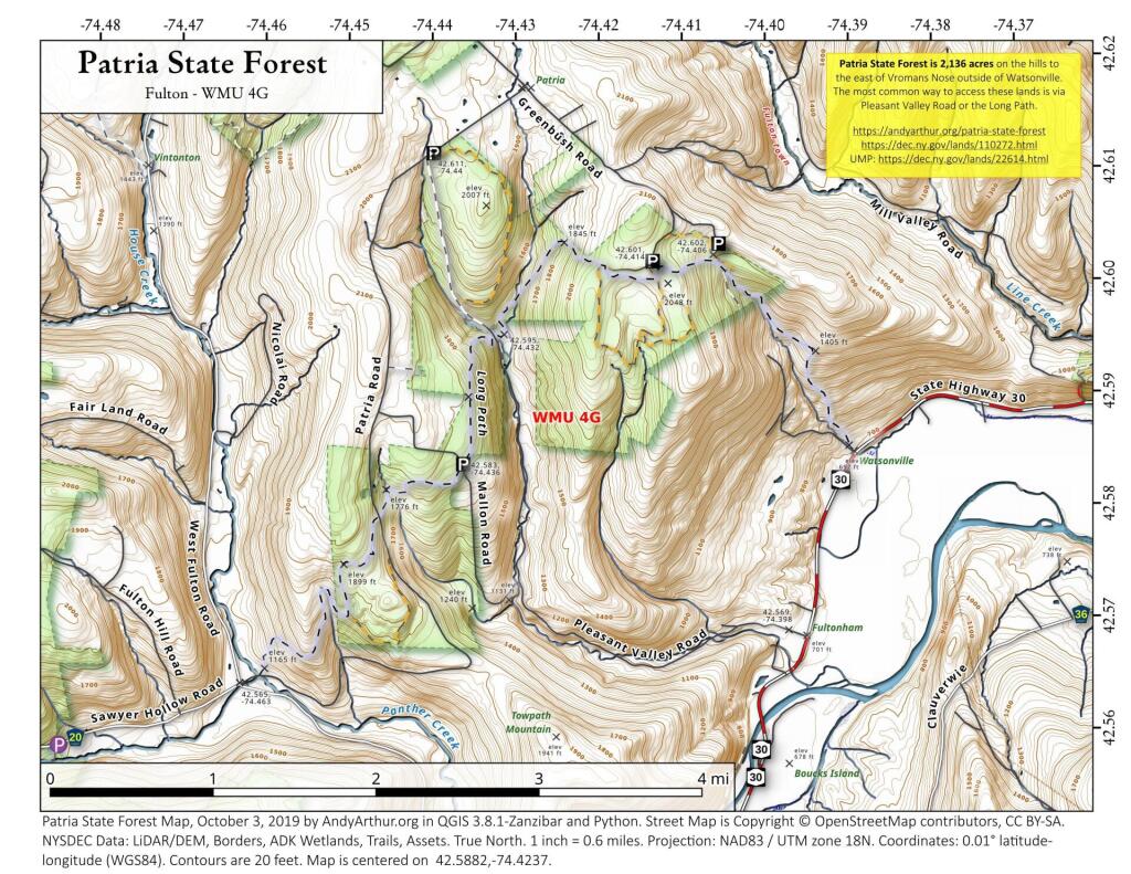
42.58821912409694,-74.42370652645279
Patria State Forest is 2,136 acres on the hills to the east of Vromans Nose outside of Watsonville. The most common way to access these lands is via Pleasant Valley Road or the Long Path.
https://andyarthur.org/patria-state-forest
https://dec.ny.gov/lands/110272.html
UMP: https://dec.ny.gov/lands/22614.html
Rensselaerville was once part of the Manor of Rensselaerswyck, as such the people who farmed the land were technically leaseholders of the patroon under a feudal system, first as part of the Dutch colony of New Netherland, then under the English colony, and then U.S. state, of New York. Some of the earliest settlement in Rensselaerville was along the five Native American paths that crossed the town in the early 18th century. The southwestern corner along one of these, that connected the Hudson River to the Schoharie Valley was the first section of the town to be settled, this would be around 1712. This path was also the one used during wars between the Stockbridge Indians and those at Schoharie.
Rensselaerville was created from part of the town of Watervliet in 1790. In 1795, the northern part of the town was lost to create the new town of Berne. Additional territory was lost from the eastern part of the town upon the formation of the town of Westerlo in 1815.
Prior to the 1920s, there was no road developed along the east side of the Scanadaga River north of wells heading up to Speculator, just a foot path. What would become NY 8 would run along the south-east side of East Branch of the Scanadaga River, and Gilmantown Road was the main route from Wells to Spectulator.
The Island Line Trail, also known as the Colchester Causeway, is a 14-mile (23 km) rail trail located in northwest Vermont. It comprises the Burlington Bike Path (Burlington), Colchester Park (Colchester) and the Allen Point Access Area (South Hero).
There was little on-line traffic left on that portion of the route and freight for Canada could be routed from Burlington north to Montreal over the somewhat longer Central Vermont Railway through St. Albans, Vermont. After several years of inactivity, restoring service on the Island Line would have required extensive rebuilding, and renovations of the three swing bridges on the line, over various bays of Lake Champlain. Ultimately all of the bridges on the route were removed, but the roadbed on the causeway across the lake survived, as it was heavily built with much use of granite. The alignment along the shores of Lake Champlain from Burlington Union Station north to the causeway was converted to form the Burlington Bike Path, and later took the Island Line name when the causeway was reopened, with a seasonal bike-ferry replacing the swing bridge in the northern portion of the causeway alignment. Due to a 200-foot (61 m) gap in the causeway, the organization Local Motion operates the Island Line Bike Ferry to shuttle cyclists across the gap.
https://en.wikipedia.org/wiki/Island_Line_Trail
https://www.localmotion.org/island_line_trail_map
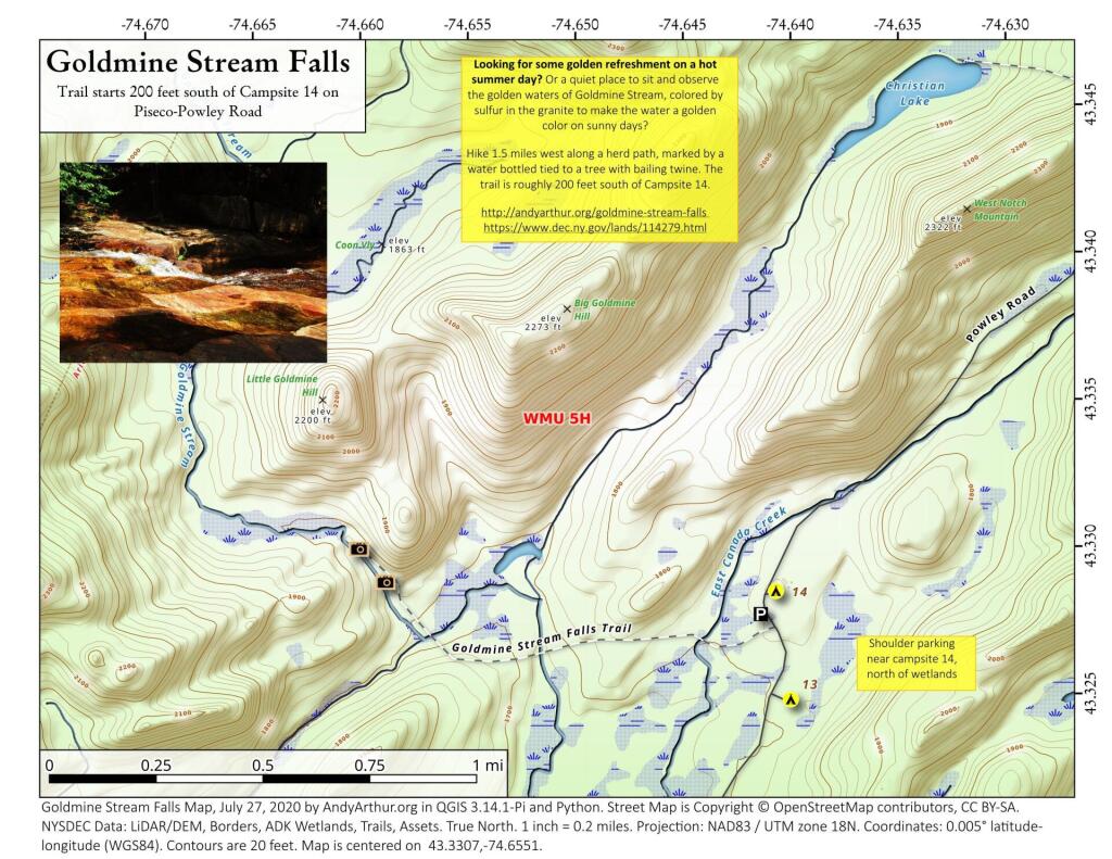
43.33072545558804,-74.6550531605912
Looking for some golden refreshment on a hot summer day? Or a quiet place to sit and observe the golden waters of Goldmine Stream, colored by sulfur in the granite to make the water a golden color on sunny days?
Hike 1.5 miles west along a herd path, marked by a water bottled tied to a tree with bailing twine. The trail is roughly 200 feet south of Campsite 14.
https://andyarthur.org/goldmine-stream-falls
https://www.dec.ny.gov/lands/114279.html
Old Route 8B is a 1915-era routing of NY 8 and 30 between Wells and Speculator that is now a dead-end after the lower bridge was closed some time ago. It runs between Auger Falls and Speculator, passing closely by Austin Falls. Old Route 8B is most famous for Robert Garrow killing a camper at the Robb Creek Mill and then fleeing up Fly Creek Road. There are several campsites along the road, and Austin Falls is a scenic location where the Sacandaga River runs through a narrow floom. The road, while paved with concrete and letter covered with two layers of asphalt only receives the most minimum of maintenance, and is quite rough and disjointed in locations. Old Route 8A refers to the 1915 routing of NY 8 and 30, which at one time ran closer to Auger Falls and wound into the valley, taking a closer path to the Sacanadaga River.