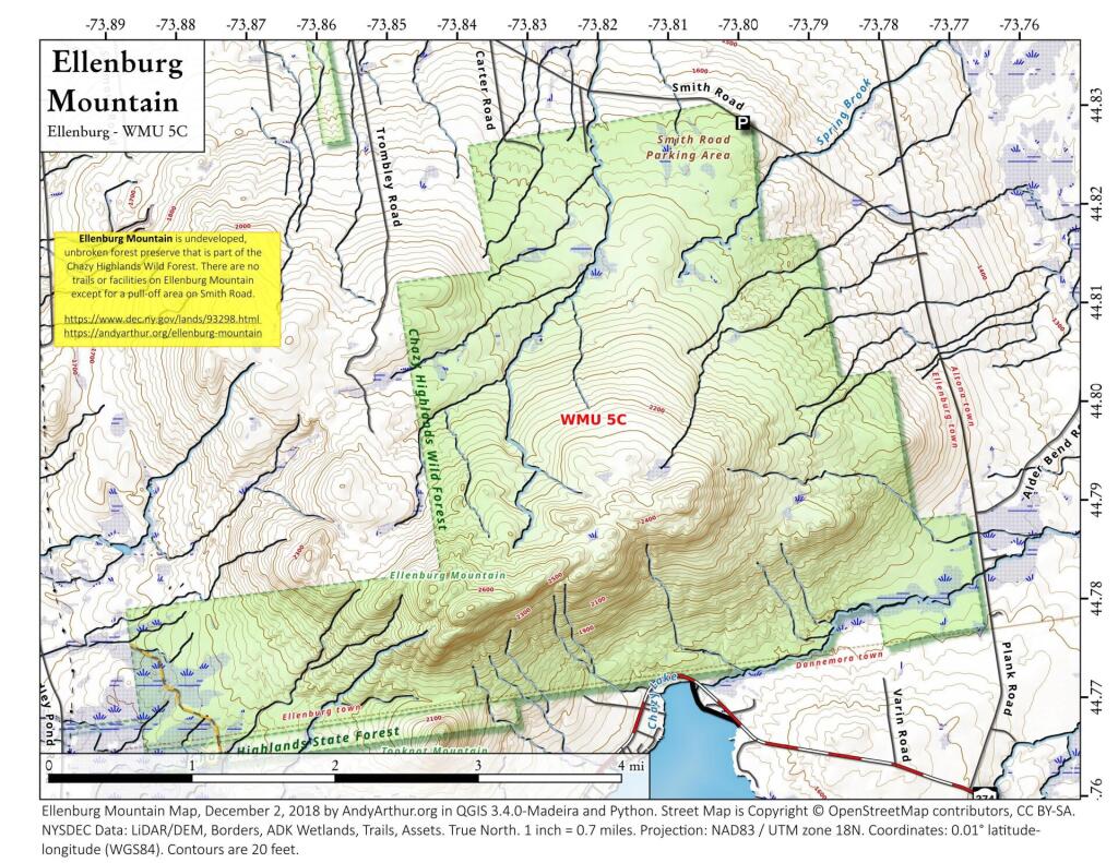
Map: Ellenburg Mountain
Download a High Resolution JPEG Image of the Ellenburg Mountain or an Adobe Acrobat Printable PDF of the Ellenburg Mountain.
About Map: Ellenburg Mountain ....
Ellenburg Mountain is one of the few in the Adirondacks that lacks formal trail but is easily accessible by local roads such as NY 374 and Smith Road in Danemora.

Bookmark my free Interactive GPS Map for your phone:
https://andyarthur.org/ny
... shows your location as a blue dot in relationship to campsites, trails, state land. This online map requires cell service, won't work in remote country, so also bring a paper map.
Free Download of New & Historical USGS 1:24k Topograpic Maps
Interactive maps with backcountry and roadside camping: New York, Pennsylvania, West Virginia & Vermont. List of NYS DEC Lean-Tos and Firetowers.
Google Spreadsheet with Roadside, Primitive and Pay Campsites
More about Chazy Highlands...
The Chazy Highlands Management Complex is comprised of approximately 36,800 acres of state land in Clinton and Franklin Counties. Included in the unit are 26,900 acres of Forest Preserve, 8,600 acres of State Forest, and 1,300 acres of Wildlife Management Area. The Adirondack Park State Land Master Plan classifies all of these lands as Wild Forest. In addition to state-owned land, the unit includes conservation easements held by the state.
The Chazy Highlands has very few developed recreational facilities. Recreational activities which do occur in the unit include hunting, fishing, and hiking. State Routes 3 and 374 bisect the area, providing access to the facilities and resources. Important local roads for access include County Route 26 (Old Route 99), Standish Road, and Plank Road.
http://www.dec.ny.gov/lands/22606.html
Maps and Interactives
Lyon Mountain Trail
Gate Road in Standish
Chazy Lake, Ellenburg Mountain, Lyon Mountain, Johnson Mountain
Lyon Mountain Fire Tower
Ellenburg Mountain
Dannemora Mountain Haul Road Trails
Dannemora Mountain
Chazy Lake
... photos, maps and other content from from Chazy Highlands.

No Comments
Tried to find the parking spot off Smith Road for Ellenburg Mountain. Found a gated access road in spot where marked on map. There are signs on that road stating no parking on roadside?
Not sure, it’s been years since I’ve been up that way and I didn’t spend much time at Ellenburg Mountain.