WMS Map: Moss Lake

Helpful Hint: While I suggest you look on blog for a downloadable PDF Map, you should be able to print or save this map by clicking the print button on the map above.

Data Sources

Road Trip to Coal Country by Nate Matthews - You can download the KMZ File used in creation of this map.

NY Aerial (2020) - High-resolution aerial photography from NYSGIS, photos taken with leaves off in spring time between the years 2016-2020. NYSGIS. WMS Service: https://orthos.its.ny.gov/ArcGIS/services/wms/Latest/MapServer/WMSServer, Layer: 0,1,2,3

NYS Roads and Trails (Invert) - NYSDEC. Download KMZ File / Download GeoJSON File
ArcMap FeatureService: https://services6.arcgis.com/DZHaqZm9cxOD4CWM/ArcGIS/rest/services/DEC_Trails/FeatureServer/ Query: 0,1,2,3,4,5,6

Campsites in Backcountry (NY/PA/VT) - Shows location of campsites and lean-tos in New York State. Derived from NYSDEC's MMS, along with OpenStreetMap, various DEC Maps and heads-up locations added by Andy Arthur. NYSDEC MMS, OpenStreet Map (©CC-BY-SA), Andy Arthur. Download KMZ File.

3DEP Elevation Hillshade. LIDAR and legacy USGS DRG Topo Derived hillshades used as a background. DEM - WMS Service: https://elevation.nationalmap.gov/arcgis/services/3DEPElevation/ImageServer/WMSServer, Layer: 3DEPElevation:Hillshade Gray

Full List of WMS and ArcMap Services - CSV Spreadsheet with all web map services currently used on the blog.

More about Moss Lake...

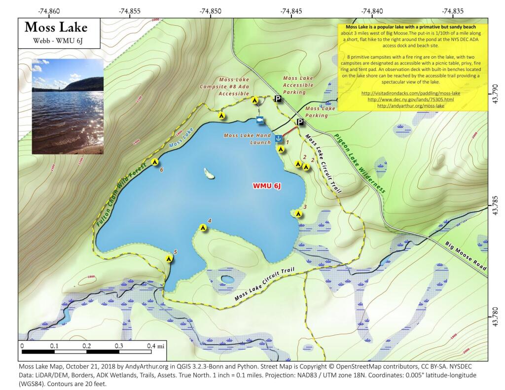
Moss Lake also known as Whipple Lake is located northwest of Eagle Bay, New York. The outlet flows into North Branch Moose River. Fish species present in the lake are brook trout, lake trout, atlantic salmon, brown trout, yellow perch, and black bullhead. There is trail access located off Big Moose Lake Road.

Leave a Reply

Your email address will not be published. Required fields are marked *