Oswegatchie River Canoe Maps
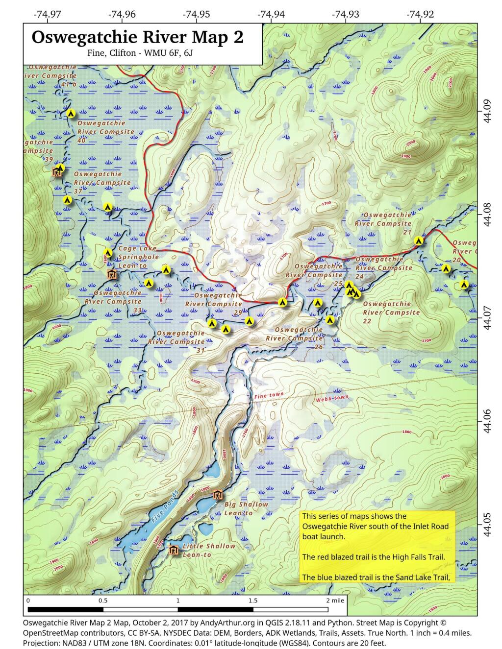
Oswegatchie River Map 2
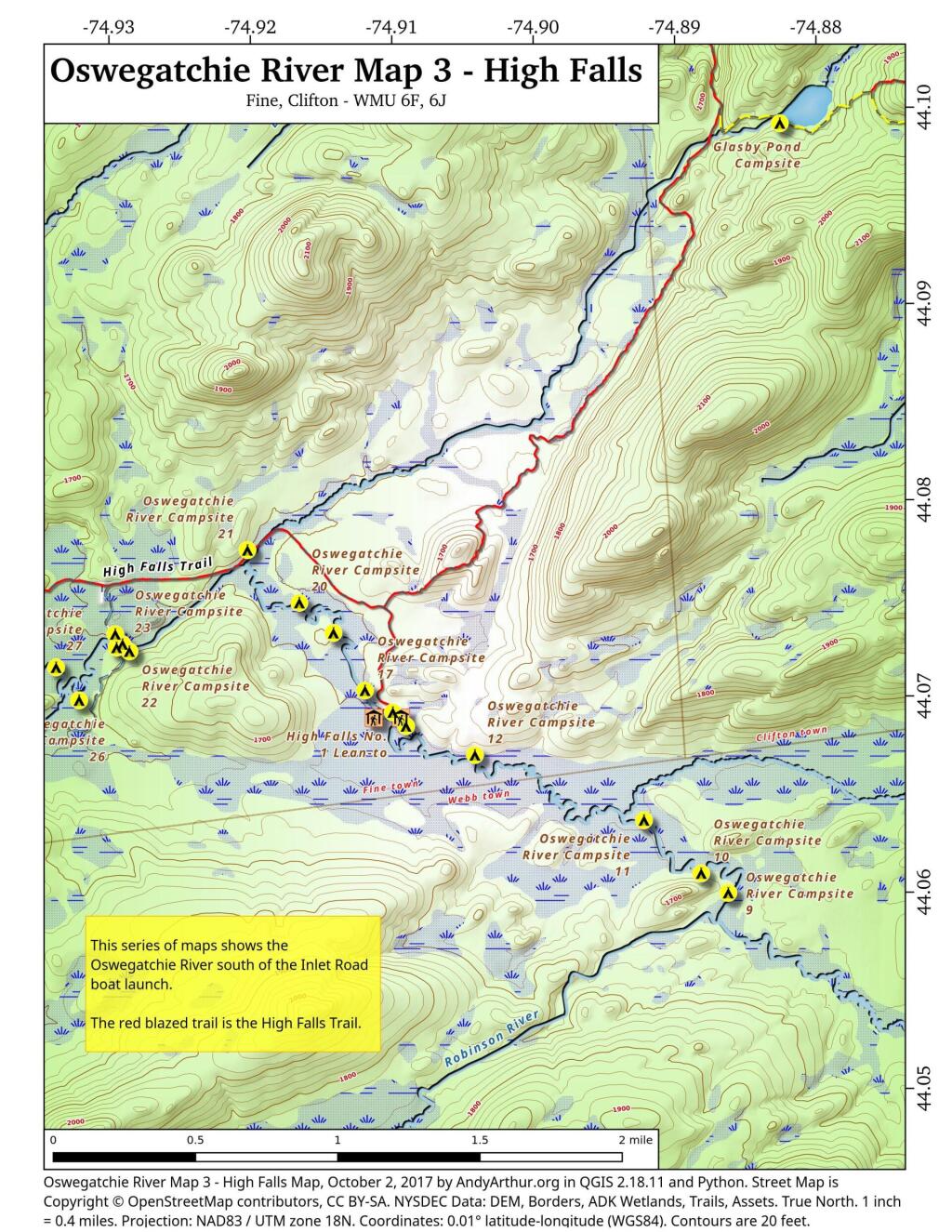
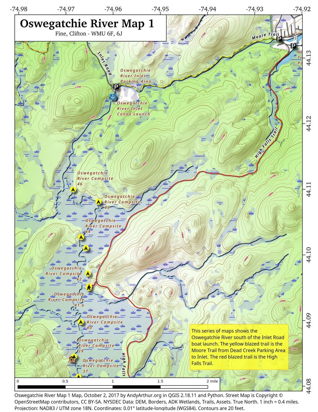
Oswegatchie River Map 1
Oswegatchie River Campsites – Coordinates and Maps
Interactive Map
Download the KML file for use in Google Maps or GPS apps.
Printable Maps
List of Oswegatchie River Campsites and Lean-Tos
Here is a list of Oswegatchie River Campsites and Lean-Tos with coordinates. They are sorted north to south. You can also get this as a Google Sheet for ease of downloading into your GPS.
| Name | Details | Location |
| Oswegatchie River Inlet Parking Area | Gravel parking area | 44.12443118931201,-74.96021183665184 |
| Oswegatchie River Inlet Canoe Launch | Hand carry launch. Oswegatchie river | 44.12409861000839,-74.96006625629072 |
| Oswegatchie River Campsite 46 | Designated campsite. No outhouse. | 44.1099997656786,-74.96849666115645 |
| Oswegatchie River Campsite 45 | Designated campsite. No outhouse. Large White Pine overstory. | 44.1081261918206,-74.9631088853723 |
| Oswegatchie River Campsite 44 | Designated campsite. No outhouse. White Pine overstory. | 44.10274849797629,-74.96679915443202 |
| Oswegatchie River Campsite 43 | Designated campsite. No outhouse. Nice site under White Pine and hemlock. | 44.101065191632905,-74.96577985008783 |
| Oswegatchie River Campsite 42 | Designated campsite. No outhouse. | 44.09720754685212,-74.96536327814668 |
| Oswegatchie River Campsite 41 B | Designated campsite. Shares full sized outhouse with 41 a. | 44.0952454709372,-74.96512556000707 |
| Oswegatchie River Campsite 41 A | Designated campsite. Shares full sized outhouse with 41 b. | 44.09498215224536,-74.96519748460433 |
| Oswegatchie River Campsite 40 | Designated campsite. No outhouse. | 44.08981881642045,-74.96686858363239 |
| Oswegatchie River Campsite 39 | Designated campsite. Shares full sized outhouse with lean-to. | 44.0845390569362,-74.96829359032023 |
| Griffin Rapids Lean-To | Oswegatchie river campsite 38. With full sized outhouse. | 44.08416539190812,-74.96874797335943 |
| Oswegatchie River Campsite 37 | Designated campsite. No outhouse. | 44.081449235808094,-74.96734861635957 |
| Oswegatchie River Campsite 36 | Appears to be rarely used. Re-signed at campsite, 05/2016. | 44.08076066223312,-74.96192854447926 |
| Oswegatchie River Campsite 21 | With full sized outhouse. outhouse needs to be replaced. | 44.0774668251364,-74.92023479225502 |
| Oswegatchie River Campsite 35 | Poor campsite on narrow bank along river. No outhouse. | 44.07631976413254,-74.96192259334101 |
| Oswegatchie River Campsite 20 | Designated campsite. No outhouse. | 44.07477874950931,-74.91657391326872 |
| Oswegatchie River Campsite 32 | Designated site. No outhouse. | 44.07468487279131,-74.95410705888409 |
| Cage Lake Springhole Lean-To | Oswegatchie River Campsite 34 and Buck Brook lean-to. With full sized outhouse. | 44.07426192277586,-74.96138724158183 |
| Oswegatchie River Campsite 33 | Designated campsite. No outhouse. | 44.073391797670325,-74.95643228093942 |
| Oswegatchie River Campsite 19 | Designated campsite. No outhouse. | 44.07324092124128,-74.9141633627036 |
| Oswegatchie River Campsite 24 | Campsite on knob just north of foot bridge. | 44.073192307051784,-74.92958639526513 |
| Oswegatchie River Campsite 23 | No obvious outhouse. | 44.07267707183023,-74.92907367419755 |
| Oswegatchie River Campsite 25 | Designated campsite. No obvious outhouse | 44.07250675167277,-74.92949519999124 |
| Oswegatchie River Campsite 22 | No obvious outhouse. | 44.07231405159984,-74.92858911655944 |
| Oswegatchie River Campsite 28 | No obvious outhouse. On narrow strip of land between river and hiking trail. | 44.07152841600008,-74.9384951811928 |
| Oswegatchie River Campsite 27 | Designated site. No outhouse. | 44.071498659692026,-74.93377315442581 |
| Oswegatchie River Campsite 17 | No obvious outhouse. | 44.07030826156362,-74.9119367954832 |
| Oswegatchie River Campsite 26 | Designated site. No outhouse. Former site of guide art leary’s camp. | 44.06982014142839,-74.93214452928088 |
| Oswegatchie River Campsite 29 | Designated campsite. No outhouse. | 44.069703084074106,-74.94295216734594 |
| Oswegatchie River Campsite 31 | Designated site. No outhouse. | 44.06949136260463,-74.94796488517912 |
| Oswegatchie River Campsite 16 | With full sized outhouse. | 44.06919421410159,-74.90997016838134 |
| Oswegatchie River Campsite 30 | Designated campsite. No outhouse. | 44.06892407580466,-74.94610904969508 |
| High Falls No. 2 Lean-To | Also here, Oswegatchie river campsite 13. With full sized outhouse. | 44.06891348697742,-74.9113129664397 |
| High Falls No. 1 Lean-To | Also here, Oswegatchie river campsite 15. With full sized outhouse. | 44.06890982511321,-74.90939691179359 |
| Oswegatchie River Campsite 14 | Shares outhouse with lean-to. | 44.06848762867845,-74.90903933983748 |
| Oswegatchie River Campsite 12 | Designated campsite. No outhouse. | 44.06701056940781,-74.90417255789619 |
| Oswegatchie River Campsite 10 | Designated campsite. No outhouse. | 44.06096855932064,-74.88818835643873 |
| Oswegatchie River Campsite 9 | Designated campsite. No outhouse. | 44.05997161595347,-74.88627678133585 |
| Oswegatchie River Campsite 8 | Designated campsite. No outhouse. | 44.05339349849945,-74.8716957113609 |
| Oswegatchie River Campsite 6 | Designated site. No outhouse. | 44.04936909651902,-74.86294215811668 |
| Oswegatchie River Campsite 5 | Designated campsite. No outhouse. | 44.048445662452906,-74.86176785303444 |
| Oswegatchie River Campsite 4 | 44.04369429633436,-74.85751646996977 | |
| Oswegatchie Canoe Carry Hand Launch | Hand carry launch, canoe launch | 44.04330626616994,-74.85744713528497 |