Little Moose Lake
The white-dashed line shows the route of the Wilson Ridge Trail, which is an old logging road that is maintained nowadays as a mountain bike trail.
The white-dashed line shows the route of the Wilson Ridge Trail, which is an old logging road that is maintained nowadays as a mountain bike trail.
Old Route 8B is a 1915-era routing of NY 8 and 30 between Wells and Speculator that is now a dead-end after the lower bridge was closed some time ago. It runs between Auger Falls and Speculator, passing closely by Austin Falls. Old Route 8B is most famous for Robert Garrow killing a camper at the Robb Creek Mill and then fleeing up Fly Creek Road. There are several campsites along the road, and Austin Falls is a scenic location where the Sacandaga River runs through a narrow floom. The road, while paved with concrete and letter covered with two layers of asphalt only receives the most minimum of maintenance, and is quite rough and disjointed in locations. Old Route 8A refers to the 1915 routing of NY 8 and 30, which at one time ran closer to Auger Falls and wound into the valley, taking a closer path to the Sacanadaga River.
I was surprised to see that NY Route 8 and 30 followed Old Route 8B well into the 1950s, if not the 1960s before the modern alignment. I would have thought such a twisty road with sharp, dangerous curves would have been re-aligned in much earlier on.
The original road was built in 1915, according to bridge inspection reports (click on blue box to pull up the report). Before then, people used Gilmantown Road past Gilmantown Lake to get from Wells to Speculator, with the portion of NY 8 along the East Branch heading south to Wells, until the 1935 bridge was built between NY 30 and NY 8 over the Sacandaga River.
The current alignment was built in 1968 it would appear, based on the fact that the Scandaga River Bridge in Speculator was constructed that year and that looking at historical topographic maps from the mid-1960s still shows the old alignment.
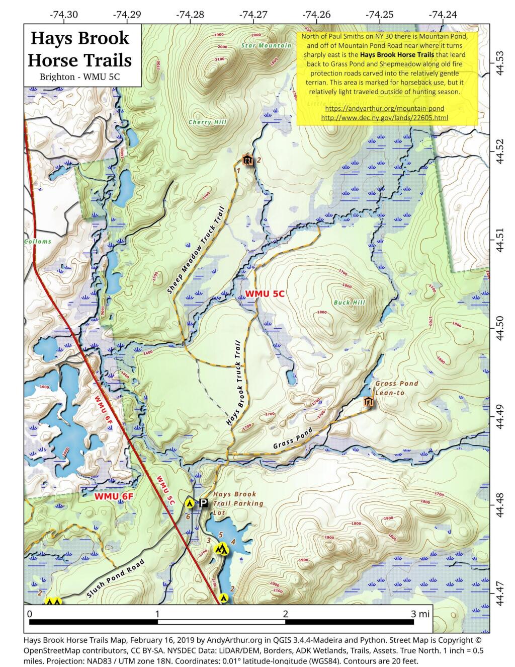
North of Mountain Pond in Paul Smiths is an old routing of NY 30 and several old fire protection roads that are used today for hiking, horseback riding, and accessing backcountry hunting locations. Known as the Hays Brook Horse Trails, there is a small parking area along Mountain Pond Road (Old Route 30), along with a falling apart wooden sign indicating the trail head.
Winter’s going to kick like a mule come next week but we’re only like 68 days away from spring and being an El Niño year it’s not going to remain cold for all that long.
Good morning! Happy Thursday. Mostly cloudy at the freezing point in Delmar. ☁ There is a west-southwest breeze at 9 mph. 🍃. There are some remaining snow banks on the ground. ☃ But not for long. ️Things will start to thaw out at around 7 am. 🌡️
Cornbread this morning with onions, garlic, spinach and lots of spices.🥧 Came out such a deep rich color and fluffy thanks to the baking soda. Do wish I had added some salt. 🍊 Then I ran a full orange, peel and all through the food processor for a fiber rich treat. 🧡 Fiber fills you up and blunts the impact of all those sugars and the inevitable insulin spike. I do poop 💩 a lot on the morning especially after all that coffee ☕ rich with cinnamon and ginger.
Today will have a slight chance of rain and snow showers after 1pm. Cloudy 🌧, with a high of 38 degrees at 2pm. Five degrees above normal, which is similar to a typical day around February 21st. West wind 6 to 9 mph. Chance of precipitation is 20%. A year ago, we had mostly sunny skies in the morning with some clearing in the afternoon. The high last year was 33 degrees. The record high of 67 was set in 2020. 8.0 inches of snow fell back in 1922.❄
Riding to work again today, 🚲 this time taking my preferred route through the Norman’s Kill Gorge as the snow and ice should be mostly gone. ☺ I really don’t love riding Delaware, I’d much rather do the rail trail. That said not sure how much I’ll be riding next week, going to be cold plus Tuesday and Wednesday are session days. Do think it’s likely I’ll be finally moving out to the burbs for work but I have a schedule ready for the shuttle 🚀. Okay, maybe not that kind of shuttle. I don’t think the cold will be that prolonged being an El Niño year, or so I tell myself.
Solar noon 🌞 is at 12:04 pm with sun having an altitude of 25.5° from the due south horizon (-45.3° vs. 6/21). A six foot person will cast a 12.6 foot shadow today compared to 2.2 feet on the first day of summer. The golden hour 🏅 starts at 3:58 pm with the sun in the southwest (233°). 📸 The sunset is in the west-southwest (241°) with the sun dropping below the horizon at 4:42 pm after setting for 3 minutes and 21 seconds with dusk around 5:13 pm, which is one minute and 5 seconds later than yesterday. 🌇 The best time to look at the stars is after 5:49 pm. At sunset, look for rain 🌧 and snow 🌨 and temperatures around 38 degrees. There will be a south-southwest breeze at 6 mph. Tomorrow will have 9 hours and 22 minutes of daytime, an increase of one minute and 27 seconds over today.
Yesterday on my way out ran into the landlord and we got chatting 🗣️ and guess what I forgot to lock 🔒 my door 🚪 or even shut it tightly. It was a mild day and the heat probably didn’t kick on, and it’s not like I have much worth stealing. 👮 Today I’ll be more careful. Going to try to leave a bit earlier today so I’m not as rushed plus I have a morning meeting to get down to. 👥
Tonight will have a slight chance of snow showers before 10pm. Mostly cloudy 🌧, with a low of 27 degrees at 4am. 11 degrees above normal, which is similar to a typical night around March 18th. South wind around 6 mph becoming west after midnight. Chance of precipitation is 20%. In 2023, we had cloudy skies in the evening, which became light snow by the early hours of the morning. It got down to 32 degrees. The record low of -26 occurred back in 1968.
15 bean soup 🍲 last night was delicious 😋 though it made the last of my carrots 🥕 dissappear and a lot of spinach and celery. I should have bought the five pound bag of carrots last week. Rye bread with lots of red onions in it for a rich flavor. Then a shredded apple run through the food processor with lots of cinnamon and ginger with a touch of peanut 🥜 butter powder after my evening walk. Not quite a slurry, I mean smoothie but good. Not so cold for the evening walk. 🌧️ Rained on the bus 🚍 ride home but stopped by the time I was filled up with that delicious soup and bread. I was in bed 🛏 by eight and up by five this morning.
Weekend continues to look rainy after first then get cold. 🌦️🤜🌬️🤜🧊Saturday, rain before noon, then showers likely, mainly between noon and 1pm. High near 48. Southeast wind 14 to 17 mph becoming southwest in the afternoon. Chance of precipitation is 80%. New precipitation amounts between a tenth and quarter of an inch possible. Sunday, a chance of snow showers after 1pm. Partly sunny, with a high near 32. Breezy. Chance of precipitation is 30%. Typical average high for the weekend is 33 degrees. I’m still thinking about at least one night up in the woods but I concede with the wind, going to be a cold weekend.
Looking ahead, next Thursday is Winnie the Pooh Day 🍯 when the sun will be setting at 4:51 pm with dusk at 5:21 pm. On that day in 2023, we had cloudy, mild, freezing rain showers and temperatures between 44 and 32 degrees. Typically, the high temperature is 32 degrees. We hit a record high of 59 back in 1973. Last week I bought honey 🛒 but I haven’t opened it yet. I’ve decided to include more natural sugars sparingly in my diet for flavor but only occasionally as a treat. That and real maple 🍁 syrup. Yum. But it’s not going to be an everyday thing and will always be paired with fiber rich foods and whole grains be it milled corn, milled oats or whole wheat foot.
Old NY 10 running on the east side of Goodman Mountain couldn't have been in use very long as it's not seen on the 1907 USGS topographic maps and by the mid-1950s has already been by-passed in favor of the modern western alignment along the lake.
An interactive map of the Northville Placid Trail, featuring campsites, lean-tos and nearby trails. The Northville–Lake Placid Trail, also known as the NPT, is a lightly traveled foot trail that runs 138 miles through the Central Adirondack Park from Northville to Lake Placid. It was laid out by the Adirondack Mountain Club in 1922 and 1923 and is maintained by the New York State Department of Environmental Conservation. It is connected to Long Path to the south, which runs through the Mohawk Valley, Heldebergs, Schoharie Valley, Catskill Mountains, Shawgunks and ultimately to George Washington Bridge in New York - New Jersey.
Also available is a printable (Adobe PDF) version of the Northville Placid Trail Maps.
Here is a listing of Campsites and Lean-To Coordinates.
Below is a listing where the Northville - Placid Trail crosses public roads. You can use these coordinates to help find trailheads.
| Street | City | ZIP | lng | lat |
| 1173 County Road 123 | Mayfield | 12117 | -74.2013797 | 43.2041425 |
| 570 Collins Gifford Vly | Northville | 12134 | -74.2077243 | 43.2138129 |
| 2003 County Road 6 | Northville | 12134 | -74.3116965 | 43.2475343 |
| 2003 County Road 6 | Northville | 12134 | -74.3123703 | 43.2479095 |
| 2003 County Road 6 | Northville | 12134 | -74.4345398 | 43.373703 |
| 1750 State Route 8 | Piseco | 12139 | -74.4959583799054 | 43.4288730112742 |
| 1730 State Route 8 | Piseco | 12139 | -74.496949368311 | 43.4283456662233 |
| 471 Old Piseco Rd | Piseco | 12139 | -74.5241317665044 | 43.4481265239214 |
| 471 Old Piseco Rd | Piseco | 12139 | -74.4911075371203 | 43.7145566153636 |
| 471 Old Piseco Rd | Piseco | 12139 | -74.4627270288044 | 43.7389165463427 |
| 8105 State Route 30 | Indian Lake | 12842 | -74.3865506809112 | 43.8422133769259 |
| 8105 State Route 30 | Indian Lake | 12842 | -74.3843450915841 | 43.8384297766447 |
| 8 Tarbell Hill Ln | Long Lake | 12847 | -74.3925084093623 | 43.9760341326559 |
| 211 Averyville Ln | Lake Placid | 12946 | -74.0136636120448 | 44.2630681820573 |