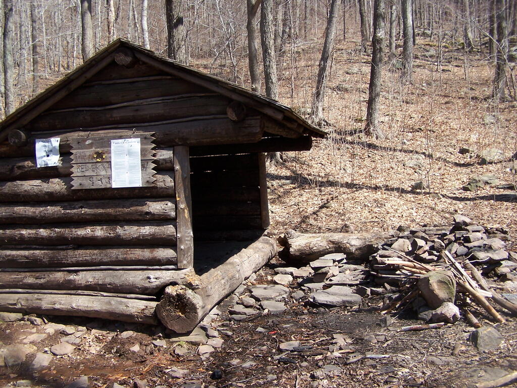
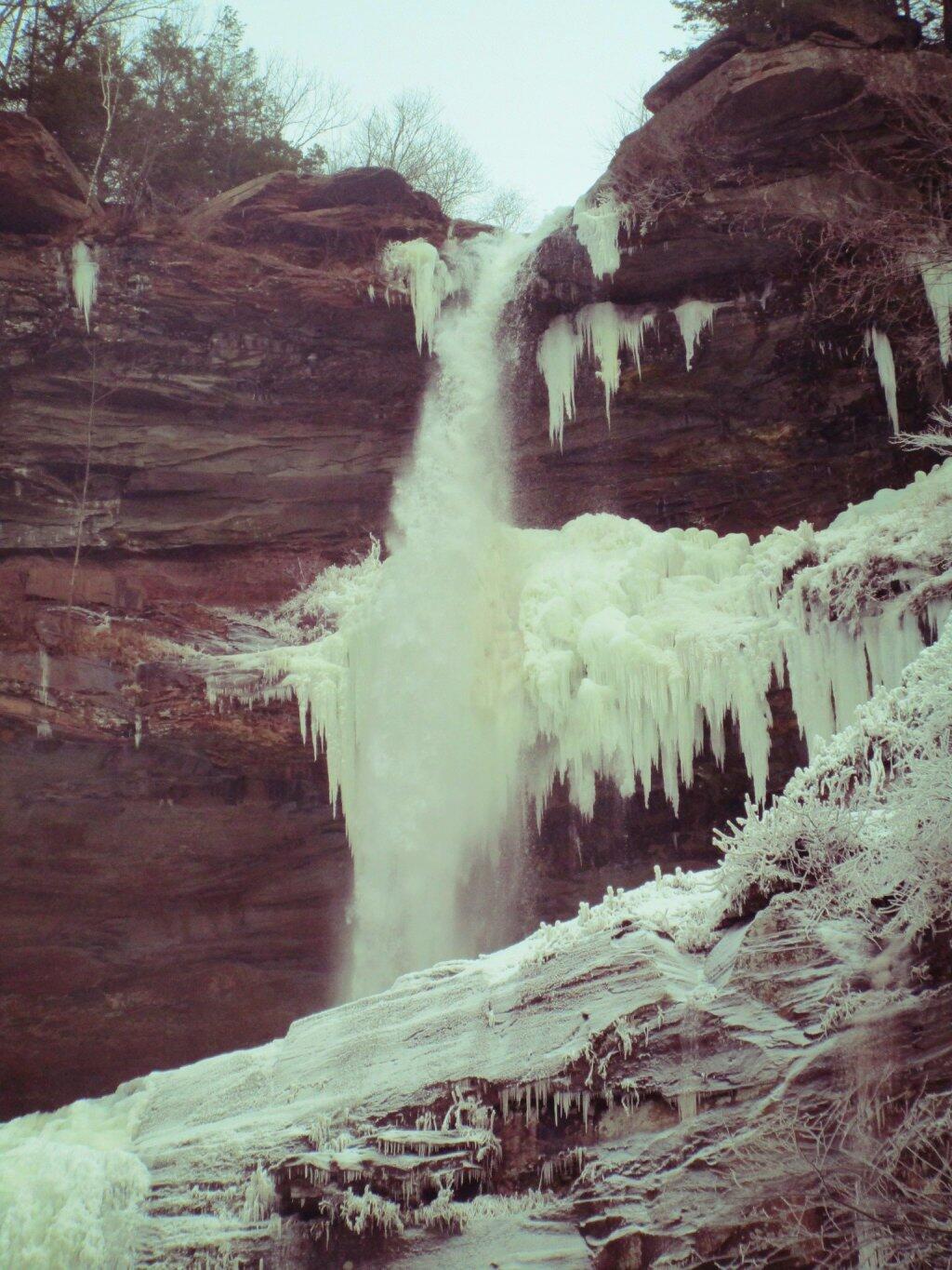
Open Burning on Utsaythana-Churchill Mountain Col
I went to bed early last night noting the ice we were getting and not wanting to deal with the risk of losing power. The power did go out and is still out so I’m shaving and showering in the dark this morning. Fortunately it’s going to warm up by midday though most of the coming week will be a bit below average.
Good morning! Happy Palm Sunday. Sunny and 19 degrees in Delmar, NY. 🌞 🌴 I bet a lot of church halls are cold and not very well lit this morning ⛪ though the sunlight through the stain glass must be beautiful. There is a north breeze at 10 mph. 🍃. The current wind chill is 5. There are 5 inches of snow on the ground. ☃ ️Things will start to thaw out at around noontime. 🌡️
I am a bit surprised how much snow 🌨 and ice I we got as I was thinking this would be just a wet rainy ☔ Saturday. Actually the bulk of the day was just heavy rain but then around 4 pm the ground temperature dropped and it turned to ice then snow. For a while the tree branches were quite ice covered and things were quite pretty.
Today will be sunny 🌞, with a high of 39 degrees at 4pm. Nine degrees below normal, which is similar to a typical day around February 27th. North wind 6 to 10 mph. A year ago, we had cloudy skies in the morning with more sun in the afternoon. The high last year was 51 degrees. The record high of 69 was set in 1976. 5.5 inches of snow fell back in 1956.❄
Laying in bed 🛏 not rushing this morning, because I don’t have coffee ☕ because my stove isn’t working nor do I have any way to cook breakfast 🍳 without power. I figure the more light ☀ with the sun in the sky the better for showering and shaving. 🚿🪒 I am not sure if they even have power 🔌 at the grocery store 🏬 so I’m thinking they may be closed though these days they probably have emergency generators. 🛻 Plus I got to scrape all that ice and snow off my truck.
Solar noon 🌞 is at 1:02 pm with sun having an altitude of 49° from the due south horizon (-21.8° vs. 6/21). A six foot person will cast a 5.2 foot shadow today compared to 2.2 feet on the first day of summer. The golden hour 🏅 starts at 6:36 pm with the sun in the west (267°). 📸 The sunset is in the west (273°) with the sun dropping below the horizon at 7:13 pm after setting for 2 minutes and 54 seconds with dusk around 7:40 pm, which is one minute and 9 seconds later than yesterday. 🌇 At dusk you’ll see the Full 🌝 Moon in the east (98°) at an altitude of 10° from the horizon, 251,916 miles away. 🚀 The best time to look at the stars is after 8:14 pm. At sunset, look for mostly clear skies 🌄 and temperatures around 33 degrees. There will be a north breeze at 5 mph. Today will have 12 hours and 25 minutes of daytime, an increase of 2 minutes and 54 seconds over yesterday.
Tonight will be mostly clear 🌃, with a low of 16 degrees at 6am. 13 degrees below normal, which is similar to a typical night around February 10th. Northwest wind around 6 mph. In 2023, we had mostly clear skies in the evening, which became light snow by the early hours of the morning. It got down to 29 degrees. The record low of 0 occurred back in 1875.
Looking ahead, there are 2 weeks until 7:30 PM Sunset 🌇 with dusk at 7:57 pm. On that day in 2023, we had mostly sunny skies and temperatures between 48 and 34 degrees. Typically, the high temperature is 55 degrees. We hit a record high of 87 back in 2010.
There are 229 summits in New York State greater then 3,000 feet elevation.
| Tallest Peak | Summit Name | Elevation | County | USGS Topo Map Name | State Land | Trail | Location |
|---|---|---|---|---|---|---|---|
| 1 | Mount Marcy | 5,344 | Essex | Mount Marcy | High Peaks Wilderness | NA | 44.112733, -73.9237833 |
| 2 | Algonquin Peak | 5,105 | Essex | North Elba | High Peaks Wilderness | Algonquin Trail | 44.1436636, -73.9865357 |
| 3 | Mount Haystack | 4,924 | Essex | Mount Marcy | High Peaks Wilderness | Haystack Trail Via Barklet Ridge | 44.1056093, -73.9004196 |
| 4 | Mount Skylight | 4,908 | Essex | Mount Marcy | High Peaks Wilderness | Skylight Trail | 44.0994987, -73.9306986 |
| 5 | Basin Mountain | 4,852 | Essex | Mount Marcy | High Peaks Wilderness | State Range Trail | 44.1211639, -73.8862527 |
| 6 | Iroquois Peak | 4,829 | Essex | North Elba | High Peaks Wilderness | Iroquois Herd Path Via Boundary Peak | 44.1369973, -73.9982027 |
| 7 | Boundary Peak | 4,826 | Essex | North Elba | High Peaks Wilderness | Iroquois Herd Path Via Boundary Peak | 44.1397749, -73.9937582 |
| 8 | Whiteface Mountain | 4,816 | Essex | Lake Placid | Whiteface Mountain Ski Center | Whiteface Landing To Whiteface Mtn. Trail | 44.3658804, -73.9026456 |
| 9 | Dix Mountain | 4,813 | Essex | Dix Mountain | High Peaks Wilderness | Elk Lake To Dix Mountain Trail | 44.0822756, -73.7862471 |
| 10 | Gray Peak | 4,800 | Essex | Mount Marcy | High Peaks Wilderness | Mount Marcy Trail Via Opalescent River | 44.1114427, -73.9348658 |
| 11 | Schofield Cobble | 4,744 | Essex | Mount Marcy | High Peaks Wilderness | NA | 44.1089427, -73.9270876 |
| 12 | Little Marcy | 4,728 | Essex | Mount Marcy | High Peaks Wilderness | Van Hoevenberg Trail To Marcy | 44.1197753, -73.910976 |
| 13 | Gothics | 4,724 | Essex | Keene Valley | High Peaks Wilderness | Beaver Meadow Falls Trail | 44.1281079, -73.8570849 |
| 14 | Mount Colden | 4,708 | Essex | North Elba | High Peaks Wilderness | Mount Colden Via Lake Arnold | 44.1269976, -73.9598674 |
| 15 | Beck-horn | 4,695 | Essex | Dix Mountain | High Peaks Wilderness | Elk Lake To Dix Mountain Trail | 44.0800534, -73.7845802 |
| 16 | Little Haystack | 4,678 | Essex | Mount Marcy | High Peaks Wilderness | Haystack Trail Via Slant Rock | 44.1103313, -73.9004197 |
| 17 | Giant Mountain | 4,623 | Essex | Rocky Peak Ridge | Giant Mountain Wilderness | North Trail To Giant Mtn. | 44.161165, -73.720279 |
| 18 | Mount Redfield | 4,603 | Essex | Mount Marcy | High Peaks Wilderness | Mt Redfield Trail | 44.094777, -73.949866 |
| 19 | Santanoni Peak | 4,596 | Essex | Santanoni Peak | High Peaks Wilderness | Bradley Pond Trail | 44.0822811, -74.1309855 |
| 20 | Wright Peak | 4,564 | Essex | North Elba | High Peaks Wilderness | Wright Peak Spur Trail | 44.1517187, -73.9801468 |
| 21 | Nippletop | 4,554 | Essex | Dix Mountain | High Peaks Wilderness | Nipple Top Trail | 44.0892202, -73.8159708 |
| 22 | Saddleback Mountain | 4,534 | Essex | North Elba | High Peaks Wilderness | State Range Trail | 44.1264414, -73.8748634 |
| 23 | Panther Peak | 4,455 | Essex | Santanoni Peak | High Peaks Wilderness | Bradley Pond Trail | 44.0983915, -74.132097 |
| 24 | Rocky Peak | 4,403 | Essex | Rocky Peak Ridge | Giant Mountain Wilderness | East Trail To Giant Mtn. Via Rocky Peak Ridge | 44.1542177, -73.7051718 |
| 25 | Macomb Mountain | 4,396 | Essex | Dix Mountain | High Peaks Wilderness | Macomb-E. Dix Trail | 44.0517211, -73.7801349 |
| 26 | Hough Peak | 4,393 | Essex | Dix Mountain | High Peaks Wilderness | S. Dix-Hough Trail | 44.0694981, -73.7776352 |
| 27 | Mount Marshall | 4,380 | Essex | Street Mountain | High Peaks Wilderness | Mt Marshall Trail | 44.1275538, -74.0118142 |
| 28 | Armstrong Mountain | 4,360 | Essex | Keene Valley | High Peaks Wilderness | Adk Range Trail | 44.1347741, -73.8490291 |
| 29 | Seward Mountain | 4,327 | Franklin | Ampersand Lake | High Peaks Wilderness | Seymour Mountain Herd Path | 44.1597799, -74.1993239 |
| 30 | Allen Mountain | 4,321 | Essex | Mount Marcy | High Peaks Wilderness | Mt Redfield Trail | 44.0708892, -73.9395871 |
| 31 | Table Top Mountain | 4,295 | Essex | North Elba | High Peaks Wilderness | Table Top Mountain Trail | 44.143663, -73.9070876 |
| 32 | Big Slide Mountain | 4,232 | Essex | Keene Valley | High Peaks Wilderness | Big Slide Trail | 44.1822721, -73.8704202 |
| 33 | Esther Mountain | 4,232 | Essex | Franklin Falls | Wilmington Wild Forest | Esther Mt Trail | 44.3869916, -73.8898673 |
| 34 | MacIntyre Mountains | 4,193 | Essex | Street Mountain | High Peaks Wilderness | Mt Marshall Trail | 44.1308868, -74.008203 |
| 35 | Lower Wolfjaw Mountain | 4,190 | Essex | Keene Valley | High Peaks Wilderness | W.a. White Trail | 44.1483845, -73.8326399 |
| 36 | Upper Wolfjaw Mountain | 4,190 | Essex | Keene Valley | High Peaks Wilderness | Adk Range Trail | 44.1406072, -73.8451402 |
| 37 | Slide Mountain | 4,167 | Ulster | Peekamoose Mountain | Slide Mountain Wilderness | Burroughs Range Trail-Wittenberg-Cornell | 41.9987034, -74.3862617 |
| 38 | Phelps Mountain | 4,137 | Essex | North Elba | High Peaks Wilderness | Phelps Mtn. Trail | 44.1569957, -73.9209775 |
| 39 | Cascade Mountain | 4,094 | Essex | Keene Valley | High Peaks Wilderness | Casade Mountain Trail | 44.2186594, -73.860143 |
| 40 | South Dix | 4,088 | Essex | Dix Mountain | High Peaks Wilderness | Macomb-E. Dix Trail | 44.060054, -73.7743014 |
| 41 | Lookout Mountain | 4,078 | Essex | Franklin Falls | Whiteface Mountain Ski Center | Esther Mt Trail | 44.3778249, -73.887645 |
| 42 | Donaldson Mountain | 4,062 | Franklin | Ampersand Lake | High Peaks Wilderness | Seymour Mountain Herd Path | 44.1539471, -74.210991 |
| 43 | Seymour Mountain | 4,055 | Franklin | Ampersand Lake | High Peaks Wilderness | Seymour Mountain Herd Path | 44.1578347, -74.1721003 |
| 44 | Colvin Range | 4,049 | Essex | Dix Mountain | High Peaks Wilderness | Colvin Trail | 44.0939424, -73.8345829 |
| 45 | Mount Colvin | 4,049 | Essex | Dix Mountain | High Peaks Wilderness | Colvin Trail | 44.0939424, -73.8345829 |
| 46 | Hunter Mountain | 4,045 | Greene | Hunter | Hunter-West Kill Wilderness | Spruceton Trail | 42.1778662, -74.2304216 |
| 47 | Mount Emmons | 4,022 | Franklin | Ampersand Lake | High Peaks Wilderness | Northville-Placid Trail | 44.1436698, -74.2140464 |
| 48 | Street Mountain | 4,022 | Essex | Street Mountain | High Peaks Wilderness | Street Mountain Trail | 44.1797741, -74.0437616 |
| 49 | Grace Peak | 4,006 | Essex | Dix Mountain | High Peaks Wilderness | Macomb-E. Dix Trail | 44.0653314, -73.7573564 |
| 50 | Yard Mountain | 3,999 | Essex | North Elba | High Peaks Wilderness | Big Slide Trail Via Yard Mtn. | 44.1747725, -73.8845874 |
| 51 | MacNaughton Mountain | 3,983 | Essex | Street Mountain | High Peaks Wilderness | Wall Face Ponds Trail | 44.1397768, -74.064317 |
| 52 | Dial Mountain | 3,980 | Essex | Dix Mountain | High Peaks Wilderness | Leach Trail | 44.1058859, -73.7959703 |
| 53 | Blake Peak | 3,976 | Essex | Dix Mountain | High Peaks Wilderness | Pinnacle Trail | 44.081443, -73.844583 |
| 54 | Green Mountain | 3,976 | Essex | Rocky Peak Ridge | Giant Mountain Wilderness | North Trail To Giant Mtn. | 44.182272, -73.714858 |
| 55 | Black Dome | 3,973 | Greene | Freehold | Windham-Blackhead Range Wilderness | Blackhead Range Trail | 42.2700864, -74.1226382 |
| 56 | Thomas Cole Mountain | 3,944 | Greene | Hensonville | Windham-Blackhead Range Wilderness | Blackhead Range Trail | 42.2709196, -74.1365275 |
| 57 | Cliff Mountain | 3,940 | Essex | Mount Marcy | High Peaks Wilderness | Mount Marcy Trail Via Opalescent River | 44.1031102, -73.9751452 |
| 58 | McDonnel Mountain | 3,940 | Essex | Mount Marcy | High Peaks Wilderness | Mt Redfield Trail | 44.0803332, -73.9340315 |
| 59 | Blackhead | 3,930 | Greene | Freehold | Windham-Blackhead Range Wilderness | Blackhead Mountain Spur Trail | 42.2678644, -74.1045818 |
| 60 | West Kill Mountain | 3,891 | Greene | Lexington | Hunter-West Kill Wilderness | Devil’s Path | 42.1678663, -74.2895904 |
| 61 | Doubletop Mountain | 3,875 | Ulster | Seager | NA | Seager Big Indian Trail | 42.0275913, -74.5282095 |
| 62 | Nye Mountain | 3,871 | Essex | Street Mountain | High Peaks Wilderness | Nye Mountain Trail | 44.1931062, -74.0240387 |
| 63 | Kilburn Mountain | 3,868 | Essex | Lake Placid | Sentinel Range Wilderness | Copperas Owen Pond Trl | 44.3028247, -73.8818114 |
| 64 | Moose Mountain | 3,868 | Essex | McKenzie Mountain | Mckenzie Mountain Wilderness | Mckenzie Mtn. Trail | 44.3506029, -74.0032049 |
| 65 | Howard Mountain | 3,852 | Essex | North Elba | High Peaks Wilderness | Klondike Notch Trail | 44.1583844, -73.8912539 |
| 66 | Cornell Mountain | 3,848 | Ulster | Phoenicia | Slide Mountain Wilderness | Burroughs Range Trail-Wittenberg-Cornell | 42.0014812, -74.3568163 |
| 67 | Graham Mountain | 3,848 | Ulster | Seager | NA | Seager Big Indian Trail | 42.0392576, -74.5495986 |
| 68 | Plateau Mountain | 3,845 | Greene | Hunter | Indian Head Wilderness | Devil’s Path | 42.1378671, -74.1743088 |
| 69 | McKenzie Mountain | 3,842 | Essex | McKenzie Mountain | Mckenzie Mountain Wilderness | Mckenzie Mtn. Trail | 44.3361593, -74.0320951 |
| 70 | Rist Mountain | 3,839 | Essex | Mount Marcy | High Peaks Wilderness | Boreas Road | 44.027559, -73.987366 |
| 71 | Sentinel Mountain | 3,835 | Essex | Keene | Sentinel Range Wilderness | Winch Pond | 44.3061581, -73.8523658 |
| 72 | Lyon Mountain | 3,829 | Clinton | Moffitsville | Chazy Highlands Wild Forest | New Lyon Mountain Trail | 44.7036537, -73.8645877 |
| 73 | T R Mountain | 3,829 | Essex | North Elba | High Peaks Wilderness | Lake Arnold Crossover | 44.143941, -73.9354222 |
| 74 | Snowy Mountain | 3,825 | Hamilton | Snowy Mountain | NA | Snowy Mt | 43.7003432, -74.3859856 |
| 75 | Table Mountain | 3,819 | Ulster | Peekamoose Mountain | Slide Mountain Wilderness | Peekamoose-Table Trail | 41.9587036, -74.4048739 |
| 76 | Peekamoose Mountain | 3,812 | Ulster | Peekamoose Mountain | Slide Mountain Wilderness | Peekamoose-Table Trail | 41.9531481, -74.398207 |
| 77 | Avalanche Mountain | 3,809 | Essex | North Elba | High Peaks Wilderness | Avalanche Pass Trail | 44.1361639, -73.9695903 |
| 78 | Averill Peak | 3,806 | Clinton | Lyon Mountain | Chazy Highlands Wild Forest | New Lyon Mountain Trail | 44.6928208, -73.8809768 |
| 79 | Sugarloaf Mountain | 3,806 | Greene | Hunter | Indian Head Wilderness | Devil’s Path | 42.1312006, -74.1501414 |
| 80 | Couchsachraga Peak | 3,793 | Essex | Santanoni Peak | High Peaks Wilderness | Cold River Horse Trail | 44.0956146, -74.1601539 |
| 81 | Boreas Mountain | 3,779 | Essex | Mount Marcy | NA | Gulf Brook Road | 44.0031138, -73.8806937 |
| 82 | Wittenberg Mountain | 3,766 | Ulster | Phoenicia | Slide Mountain Wilderness | Burroughs Range Trail-Wittenberg-Cornell | 42.0081478, -74.3473716 |
| 83 | Panther Mountain | 3,763 | Hamilton | Snowy Mountain | NA | Snowy Mt | 43.7367317, -74.3907093 |
| 84 | Burroughs Range | 3,760 | Ulster | Phoenicia | Slide Mountain Wilderness | Burroughs Range Trail-Wittenberg-Cornell | 42.0084255, -74.3476494 |
| 85 | Blue Mountain | 3,750 | Hamilton | Blue Mountain Lake | Blue Mountain Wild Forest | Blue Mountain Trail | 43.8725634, -74.4009917 |
| 86 | Porter Mountain | 3,750 | Essex | Keene Valley | High Peaks Wilderness | Porter Mountain Trail Via Marcy Field | 44.2153262, -73.8434754 |
| 87 | Wakely Mountain | 3,750 | Hamilton | Wakely Mountain | Wakely Mountain Primitive Area | Wakely Mountain Trail | 43.7358986, -74.5151595 |
| 88 | Little Nippletop | 3,720 | Essex | Mount Marcy | High Peaks Wilderness | Elk Lake To Marcy Trail | 44.0853327, -73.9201422 |
| 89 | Wallface Mountain | 3,720 | Essex | Street Mountain | High Peaks Wilderness | Indian Pass Trail | 44.1378317, -74.0365378 |
| 90 | Panther Mountain | 3,714 | Ulster | Shandaken | Slide Mountain Wilderness | Giant Ledge-Panther Mountian-Fox Hollow Trail | 42.0564799, -74.3945946 |
| 91 | Balsam Lake Mountain | 3,707 | Ulster | Seager | Balsam Lake Mountain Wild Forest | Balsam Lake Mountain Trail | 42.0459236, -74.5940438 |
| 92 | Henderson Mountain | 3,707 | Essex | Mount Adams | High Peaks Wilderness | Bradley Pond Trail | 44.0978353, -74.0976509 |
| 93 | Hoffman Mountain | 3,701 | Essex | Blue Ridge | Hoffman Notch Wilderness | Hoffman Notch Trail | 43.9114489, -73.8168 |
| 94 | Lone Mountain | 3,697 | Ulster | Peekamoose Mountain | Slide Mountain Wilderness | Peekamoose-Table Trail | 41.9692592, -74.3893177 |
| 95 | Big Indian Mountain | 3,694 | Ulster | Shandaken | Big Indian Wilderness | Pine Hill West Branch Trail | 42.0350915, -74.4965421 |
| 96 | Hurricane Mountain | 3,688 | Essex | Rocky Peak Ridge | Hurricane Mountain Wilderness | East Hurricane Mtn Trial | 44.235326, -73.7106926 |
| 97 | Friday Mountain | 3,681 | Ulster | West Shokan | Slide Mountain Wilderness | Burroughs Range Trail-Wittenberg-Cornell | 41.9875924, -74.3620944 |
| 98 | Rusk Mountain | 3,678 | Greene | Lexington | Rusk Mountain Wild Forest | Spruceton Trail | 42.2006434, -74.2770897 |
| 99 | Cheney Cobble | 3,674 | Essex | Mount Marcy | High Peaks Wilderness | East River Trail | 44.0445021, -73.9648654 |
| 100 | Lewey Mountain | 3,665 | Hamilton | Snowy Mountain | West Canada Lake Wilderness | Sucker Brook Trail | 43.6642328, -74.4412649 |
| 101 | Seward Mountains | 3,665 | Franklin | Ampersand Lake | High Peaks Wilderness | Calkins Creek Truck Trail | 44.1561694, -74.2148801 |
| 102 | Santanoni Mountains | 3,661 | Essex | Santanoni Peak | High Peaks Wilderness | Bradley Pond Trail | 44.0881144, -74.138486 |
| 103 | Buell Mountain | 3,652 | Hamilton | Snowy Mountain | NA | Snowy Mt | 43.7161764, -74.4065426 |
| 104 | High Peak | 3,645 | Greene | Kaaterskill Clove | Kaaterskill Wild Forest | Kaaterskill High Peak Trail | 42.1620334, -74.0801381 |
| 105 | Little Whiteface Mountain | 3,638 | Essex | Lake Placid | Whiteface Mountain Ski Center | Whiteface Landing To Whiteface Mtn. Trail | 44.3558804, -73.891534 |
| 106 | Burtons Peak | 3,632 | Essex | Keene Valley | NA | The Brothers Trail | 44.1925, -73.8586111 |
| 107 | Fir Mountain | 3,629 | Ulster | Shandaken | Big Indian Wilderness | Pine Hill West Branch Trail | 42.0275916, -74.4690414 |
| 108 | Twin Mountain | 3,629 | Greene | Hunter | Indian Head Wilderness | Devil’s Path | 42.1256453, -74.1290294 |
| 109 | Little Moose Mountain | 3,609 | Hamilton | Wakely Mountain | Little Moose Wilderness | Otter Brook Trail | 43.6700663, -74.5707151 |
| 110 | Balsam Mountain | 3,606 | Ulster | Shandaken | Big Indian Wilderness | Pine Hill West Branch Trail | 42.0909235, -74.4882082 |
| 111 | Calamity Mountain | 3,606 | Essex | Mount Adams | High Peaks Wilderness | Calamity Brook Trail | 44.1028328, -74.0043132 |
| 112 | Sunrise Mountain | 3,606 | Essex | Dix Mountain | High Peaks Wilderness | Elk Lake To Dix Mountain Trail | 44.0247778, -73.7904124 |
| 113 | Balsam Cap | 3,602 | Ulster | West Shokan | Slide Mountain Wilderness | Burroughs Range Trail-Wittenberg-Cornell | 41.9770369, -74.3573722 |
| 114 | Stewart Mountain | 3,602 | Essex | Keene | Sentinel Range Wilderness | Winch Pond | 44.3261581, -73.8562549 |
| 115 | North Dome | 3,596 | Greene | Lexington | Hunter-West Kill Wilderness | Devil’s Path | 42.1734217, -74.3490366 |
| 116 | Pillsbury Mountain | 3,589 | Hamilton | Spruce Lake | West Canada Lake Wilderness | Pillsbury Mountain Trail | 43.580901, -74.5120992 |
| 117 | Slide Mountain | 3,586 | Essex | Lake Placid | Sentinel Range Wilderness | Barkeater Cliffs Campsite Trail | 44.2767136, -73.8862561 |
| 118 | Eagle Mountain | 3,573 | Ulster | Seager | Big Indian Wilderness | Pine Hill West Branch Trail | 42.0620352, -74.50932 |
| 119 | Dun Brook Mountain | 3,563 | Hamilton | Dun Brook Mountain | NA | Deer Pond Road | 43.890897, -74.3187666 |
| 120 | Saddleback Mountain | 3,560 | Essex | Jay Mountain | Jay Mountain Wilderness | Jay Mountain Trail | 44.2953258, -73.6676367 |
| 121 | Indian Head Mountain | 3,553 | Greene | Woodstock | Indian Head Wilderness | Devil’s Path | 42.116201, -74.1145846 |
| 122 | Fishing Brook Mountain | 3,550 | Essex | Dun Brook Mountain | Blue Mountain Wild Forest | Deer Pond Road | 43.9342303, -74.2946002 |
| 123 | Mount Sherrill | 3,550 | Greene | Lexington | Hunter-West Kill Wilderness | Devil’s Path | 42.1756439, -74.3729262 |
| 124 | Gooseberry Mountain | 3,540 | Essex | Keene Valley | High Peaks Wilderness | Orebed Brook Trail | 44.1367187, -73.8731969 |
| 125 | Bearpen Mountain | 3,530 | Delaware | Prattsville | Bearpen Mountain State Forest | Access Trail | 42.2734189, -74.4840396 |
| 126 | Vly Mountain | 3,530 | Greene | West Kill | Bearpen Mountain State Forest | Snowmobile Trail | 42.2453645, -74.4459834 |
| 127 | Windham High Peak | 3,527 | Greene | Hensonville | Windham-Blackhead Range Wilderness | Escarpment Trail | 42.3148069, -74.1434718 |
| 128 | Halcott Mountain | 3,524 | Greene | West Kill | Halcott Mountain Wild Forest | Condon Hollow Rd. | 42.1800882, -74.4379281 |
| 129 | Mount Adams | 3,520 | Essex | Mount Adams | High Peaks Wilderness | Mt Adams Trail | 44.0867231, -74.0257027 |
| 130 | Pitchoff Mountain | 3,501 | Essex | North Elba | Sentinel Range Wilderness | Pitchoff Mountain Trail | 44.2375474, -73.8776443 |
| 131 | Noonmark Mountain | 3,491 | Essex | Keene Valley | High Peaks Wilderness | Stimson Trail | 44.1289404, -73.7720809 |
| 132 | Rocky Mountain | 3,478 | Ulster | West Shokan | Slide Mountain Wilderness | Peekamoose-Table Trail | 41.9728703, -74.3726505 |
| 133 | Little Santanoni Mountain | 3,471 | Essex | Santanoni Peak | High Peaks Wilderness | Moose Pond Horse Trail | 44.0731156, -74.1670981 |
| 134 | Spotted Mountain | 3,461 | Essex | Underwood | High Peaks Wilderness | Macomb-E. Dix Trail | 44.0769975, -73.7440228 |
| 135 | Manbury Mountain | 3,455 | Hamilton | Wakely Mountain | Little Moose Wilderness | Otter Brook Trail | 43.6653442, -74.5532143 |
| 136 | Blue Ridge Mountain | 3,451 | Essex | Blue Ridge | Hoffman Notch Wilderness | Hoffman Notch Trail | 43.9247817, -73.8148558 |
| 137 | Roundtop | 3,451 | Delaware | Prattsville | Bearpen Mountain State Forest | Ski Run Road | 42.2939737, -74.4904283 |
| 138 | Roundtop Mountain | 3,451 | Greene | Kaaterskill Clove | Kaaterskill Wild Forest | Kaaterskill High Peak Trail | 42.1684222, -74.094583 |
| 139 | Olderbark Mountain | 3,438 | Greene | Bearsville | Indian Head Wilderness | Mink Hollow Trail | 42.1142565, -74.1909765 |
| 140 | Puffer Mountain | 3,438 | Hamilton | Bullhead Mountain | Siamese Ponds Wilderness | Puffer Pond Brook Trail | 43.6617318, -74.1993082 |
| 141 | Morgan Mountain | 3,432 | Essex | Wilmington | Wilmington Wild Forest | Cooper Kill Trail | 44.4186582, -73.8593108 |
| 142 | Wolf Pond Mountain | 3,425 | Essex | Cheney Pond | NA | Gulf Brook Road | 43.9892253, -73.8781933 |
| 143 | Stoppel Point | 3,422 | Greene | Kaaterskill Clove | Windham-Blackhead Range Wilderness | Escarpment Trail | 42.2250879, -74.0651364 |
| 144 | Huntersfield Mountain | 3,419 | Greene | Ashland | Huntersfield State Forest | Huntersfield Access Trail #8/Long Path Access | 42.355638, -74.3465339 |
| 145 | Cellar Mountain | 3,405 | Hamilton | Wakely Mountain | Moose River Plains Wild Forest | Cellar Pond Trail | 43.7122879, -74.5429375 |
| 146 | Haynes Mountain | 3,405 | Ulster | Seager | Big Indian Wilderness | Pine Hill West Branch Trail | 42.0792571, -74.5079309 |
| 147 | Sawtooth Mountains | 3,402 | Franklin | Street Mountain | High Peaks Wilderness | Northville-Placid Trail | 44.1928314, -74.1134874 |
| 148 | Bear Den Mountain | 3,389 | Essex | Dix Mountain | High Peaks Wilderness | Leach Trail | 44.1194964, -73.792915 |
| 149 | Pinnacle | 3,389 | Essex | Dix Mountain | High Peaks Wilderness | Pinnacle Trail Spur To Summit | 44.0583887, -73.8640277 |
| 150 | Vanderwhacker Mountain | 3,389 | Essex | Vanderwhacker Mountain | Vanderwhacker Mountain Wild Forest | Vanderwhacker Firetower Trail | 43.8983963, -74.0959781 |
| 151 | Jay Mountain | 3,379 | Essex | Jay Mountain | Jay Mountain Wilderness | Jay Mountain Trail | 44.3125477, -73.685693 |
| 152 | Spruce Top | 3,379 | Greene | Hunter | NA | Devil’s Path | 42.1506447, -74.1679195 |
| 153 | Spruce Mountain | 3,376 | Ulster | Shandaken | Big Indian Wilderness | Phoenicia East Branch Trail | 42.0175919, -74.4498744 |
| 154 | Belle Ayr Mountain | 3,373 | Ulster | Shandaken | Belleayre Mountain Ski Center | NA | 42.1159229, -74.4979304 |
| 155 | Evergreen Mountain | 3,369 | Greene | Lexington | Rusk Mountain Wild Forest | Devil’s Path | 42.2117542, -74.3079238 |
| 156 | Hedgehog Mountain | 3,366 | Essex | Keene Valley | High Peaks Wilderness | Rooster Comb And Hedgehog Trail | 44.159495, -73.8109724 |
| 157 | Balsam Mountain | 3,353 | Greene | West Kill | Hunter-West Kill Wilderness | Condon Hollow Rd. | 42.1836992, -74.387371 |
| 158 | Kempshall Mountain | 3,350 | Hamilton | Kempshall Mountain | High Peaks Wilderness | Northville-Placid Trail | 44.0236734, -74.3271041 |
| 159 | Buck Mountain | 3,346 | Hamilton | Snowy Mountain | West Canada Lake Wilderness | Snowy Mt | 43.6947879, -74.4368212 |
| 160 | Mount Pisgah | 3,340 | Delaware | Margaretville | NA | Mountain Brook Road | 42.2211973, -74.7357125 |
| 161 | MacDonough Mountain | 3,320 | Essex | Jay Mountain | Jay Mountain Wilderness | Jay Mountain Trail | 44.3050482, -73.644025 |
| 162 | Debar Mountain | 3,317 | Franklin | Debar Mountain | Debar Mountain Wild Forest | Debar Mountain Trail | 44.6033852, -74.2204351 |
| 163 | Bullhead Mountain | 3,314 | Warren | Bullhead Mountain | Siamese Ponds Wilderness | John Pond Crossover Trail | 43.7017316, -74.1804199 |
| 164 | Laramore Mountain | 3,314 | Essex | Keene Valley | High Peaks Wilderness | Casade Mountain Trail | 44.2258813, -73.8501427 |
| 165 | Tripod Mountain | 3,307 | Essex | Rocky Peak Ridge | Giant Mountain Wilderness | Hopkin Via Direct Trail | 44.1983824, -73.736248 |
| 166 | Metcalf Mountain | 3,304 | Hamilton | Blue Mountain Lake | Blue Ridge Wilderness | Gould Road | 43.7522873, -74.4957146 |
| 167 | Wyman Mountain | 3,304 | Essex | Underwood | High Peaks Wilderness | Macomb-E. Dix Trail | 44.0581093, -73.7445779 |
| 168 | Jay Mountains | 3,297 | Essex | Jay Mountain | Jay Mountain Wilderness | Jay Mountain Trail | 44.308659, -73.6704147 |
| 169 | Eleventh Mountain | 3,294 | Warren | Bakers Mills | Siamese Ponds Wilderness | Bog Meadow Trail | 43.6142322, -74.0720783 |
| 170 | Schultice Mountain | 3,284 | Delaware | Roxbury | NA | Ski Run Road | 42.3186948, -74.5157062 |
| 171 | Cellar Mountain | 3,281 | Hamilton | Snowy Mountain | West Canada Lake Wilderness | Sucker Brook Trail | 43.6411776, -74.4443199 |
| 172 | Plattekill Mountain | 3,268 | Delaware | Hobart | Plattekill State Forest | Mountain Brook/ Harold Roberts Access Trail | 42.2667522, -74.6482102 |
| 173 | South Pond Mountain | 3,258 | Hamilton | South Pond Mountain | Siamese Ponds Wilderness | County Line Brook Trail | 43.5900656, -74.2204175 |
| 174 | Hemlock Mountain | 3,248 | Ulster | Shandaken | Big Indian Wilderness | Phoenicia East Branch Trail | 42.0128698, -74.4390407 |
| 175 | Peaked Mountain | 3,235 | Essex | Jay Mountain | Hurricane Mountain Wilderness | Soda Range Trail | 44.2656034, -73.6993039 |
| 176 | Onteora Mountain | 3,232 | Greene | Hunter | NA | Blackhead Range Trail | 42.2223098, -74.1679184 |
| 177 | Kitty Cobble | 3,225 | Hamilton | Wakely Mountain | West Canada Lake Wilderness | Otter Brook Trail | 43.6295111, -74.6229377 |
| 178 | Baldwin Hill | 3,218 | Essex | Franklin Falls | Mckenzie Mountain Wilderness | Esther Mt Trail | 44.3847694, -73.9195905 |
| 179 | Richmond Mountain | 3,218 | Greene | Ashland | Mount Pisgah State Forest | Long Path Hiking Trail | 42.367582, -74.270976 |
| 180 | Squaw Mountain | 3,218 | Hamilton | Indian Lake | NA | Snowy Mt | 43.7270094, -74.3420956 |
| 181 | Dug Mountain | 3,215 | Hamilton | Kunjamuk River | NA | Long Pond Trail | 43.583122, -74.345146 |
| 182 | Hamilton Mountain | 3,215 | Hamilton | Wells | Silver Lake Wilderness | West River Road | 43.412013, -74.3673645 |
| 183 | Mount Alton | 3,212 | Essex | Lake Placid | Mckenzie Mountain Wilderness | Whiteface Mountain Trail | 44.3717139, -73.9662589 |
| 184 | Utsayantha Mountain | 3,209 | Delaware | Stamford | NA | Ward Allen Road | 42.3992472, -74.5895953 |
| 185 | Van Wyck Mountain | 3,202 | Ulster | Peekamoose Mountain | Slide Mountain Wilderness | Phoenicia East Branch Trail | 41.9523147, -74.4354304 |
| 186 | Colonels Chair | 3,199 | Greene | Hunter | NA | Colonel’s Chair Trail | 42.2006434, -74.2306991 |
| 187 | Gore Mountain | 3,199 | Warren | Gore Mountain | Gore Mountain Ski Center | Schaefer Trail | 43.6764539, -74.035134 |
| 188 | Chase Mountain | 3,192 | Essex | Rocky Peak Ridge | Hurricane Mountain Wilderness | North Hurricane Trail | 44.2417145, -73.7248599 |
| 189 | Knob Lock Mountain | 3,192 | Essex | Rocky Peak Ridge | Giant Mountain Wilderness | Hurricane Trail From 9n | 44.2003271, -73.7073583 |
| 190 | McGregor Mountain | 3,192 | Delaware | Stamford | Stamford Fp Detached Parcel | Relay Public Forest Access Road | 42.3900808, -74.5790396 |
| 191 | Weston Mountain | 3,192 | Essex | Jay Mountain | Hurricane Mountain Wilderness | Soda Range Trail | 44.2642144, -73.7079152 |
| 192 | Burnt Knob | 3,189 | Greene | Freehold | Windham-Blackhead Range Wilderness | Escarpment Trail | 42.3020297, -74.1190264 |
| 193 | Burgess Mountain | 3,189 | Hamilton | Rock Lake | NA | Bear Trap Brook Trail | 43.7520092, -74.3565416 |
| 194 | North Mountain | 3,186 | Greene | Kaaterskill Clove | Windham-Blackhead Range Wilderness | Escarpment Trail | 42.2175881, -74.0487469 |
| 195 | Payne Mountain | 3,182 | Hamilton | Snowy Mountain | Moose River Plains Wild Forest | Northville-Placid Trail | 43.7231211, -74.4951582 |
| 196 | Hopkins Mountain | 3,169 | Essex | Rocky Peak Ridge | Giant Mountain Wilderness | Hopkins Mtn. Via Spread Eagle Mtn. | 44.1833828, -73.7490257 |
| 197 | Spruce Lake Mountain | 3,163 | Hamilton | Spruce Lake Mountain | West Canada Lake Wilderness | Northville-Placid Trail | 43.5120126, -74.6532121 |
| 198 | Tongue Mountain | 3,159 | Hamilton | Dun Brook Mountain | NA | Northville-Placid Trail | 43.9114522, -74.3454349 |
| 199 | Catamount Mountain | 3,153 | Clinton | Wilmington | Taylor Pond Wild Forest | Catamount Trail | 44.459214, -73.8723668 |
| 200 | Wildcat Mountain | 3,153 | Ulster | Peekamoose Mountain | Slide Mountain Wilderness | Pine Hill West Branch Trail | 41.9775924, -74.4759867 |
| 201 | White Man Mountain | 3,146 | Delaware | Roxbury | NA | Access Trail | 42.2845295, -74.5340406 |
| 202 | Bradley Mountain | 3,140 | Hamilton | Wakely Mountain | Blue Ridge Wilderness | Cellar Pond Trail | 43.7378431, -74.5546055 |
| 203 | Overlook Mountain | 3,136 | Ulster | Woodstock | Overlook Mountain Wild Forest | Firetower Spur | 42.0850905, -74.0931954 |
| 204 | Mount Tamarac | 3,127 | Essex | McKenzie Mountain | Mckenzie Mountain Wilderness | Jackrabbit Trail | 44.3267144, -74.0204281 |
| 205 | Mount Morris | 3,117 | Franklin | Tupper Lake | NA | Goodman Mountain Trail | 44.1595046, -74.475168 |
| 206 | Acra Point | 3,110 | Greene | Freehold | Windham-Blackhead Range Wilderness | Escarpment Trail | 42.2964745, -74.0998591 |
| 207 | Round Mountain | 3,107 | Essex | Keene Valley | High Peaks Wilderness | Weston Trail Spur To Round Mt | 44.1317179, -73.7515245 |
| 208 | Cave Mountain | 3,104 | Greene | Hensonville | Elm Ridge Wild Forest | North Face Trail | 42.2859185, -74.2462543 |
| 209 | Pete Gay Mountain | 3,097 | Warren | Gore Mountain | NA | Schaefer Trail | 43.6903427, -74.0443015 |
| 210 | Plattekill Mountain | 3,091 | Greene | Woodstock | Indian Head Wilderness | Overlook Trail | 42.1073123, -74.0865281 |
| 211 | Mount Andrew | 3,081 | Essex | Mount Adams | High Peaks Wilderness | Bradley Pond Trail | 44.0564482, -74.093483 |
| 212 | County Line Mountain | 3,081 | Hamilton | South Pond Mountain | Siamese Ponds Wilderness | Siamese Ponds Trail | 43.6114543, -74.2006952 |
| 213 | High Point | 3,074 | Ulster | West Shokan | Sundown Wild Forest | Ashokan High Point | 41.9248149, -74.2879263 |
| 214 | Rose Mountain | 3,074 | Ulster | West Kill | NA | Rochester Hollow | 42.1506445, -74.4379284 |
| 215 | Cowan Mountain | 3,068 | Delaware | Hobart | NA | Relay Public Forest Access Road | 42.3450825, -74.6498756 |
| 216 | Round Top | 3,068 | Delaware | Hobart | Plattekill State Forest | Mountain Brook/ Harold Roberts Access Trail | 42.2714741, -74.6832109 |
| 217 | Churchill Mountain | 3,064 | Delaware | Stamford | NA | Relay Public Forest Access Road | 42.388692, -74.6098738 |
| 218 | Irish Mountain | 3,064 | Delaware | Roxbury | NA | Ski Run Road | 42.3356386, -74.5262617 |
| 219 | Swart Mountain | 3,061 | Hamilton | Lake Pleasant | Silver Lake Wilderness | West River Road | 43.3967355, -74.3815314 |
| 220 | Scarface Mountain | 3,058 | Essex | McKenzie Mountain | Saranac Lakes Wild Forest | Scarface Mountain Trail | 44.2647717, -74.0737646 |
| 221 | T Lake Mountain | 3,058 | Hamilton | Piseco Lake | West Canada Lake Wilderness | T Lake Trail | 43.4470133, -74.5770967 |
| 222 | Bailey Hill | 3,054 | Essex | Cheney Pond | Hoffman Notch Wilderness | Hoffman Notch Trail | 43.9108943, -73.9026366 |
| 223 | Bald Peak | 3,054 | Essex | Rocky Peak Ridge | Giant Mountain Wilderness | East Trail To Giant Mtn. Via Rocky Peak Ridge | 44.1597731, -73.6654114 |
| 224 | Little Rocky Mountain | 3,051 | Greene | Bearsville | Indian Head Wilderness | Warner Creek Trail | 42.1150898, -74.2040325 |
| 225 | Denman Mountain | 3,048 | Sullivan | Claryville | NA | Denman Mountain Snowmobile Trail | 41.90287, -74.5396005 |
| 226 | Woodhull Mountain | 3,045 | Ulster | Peekamoose Mountain | NA | Phoenicia East Branch Trail | 41.9459259, -74.4637647 |
| 227 | Barkaboom Mountain | 3,005 | Delaware | Arena | Dry Brook Ridge Wild Forest | Touch-Me-Not-Trail | 42.0717554, -74.7201571 |
| 228 | Stony Creek Mountain | 3,002 | Franklin | Stony Creek Mountain | High Peaks Wilderness | Ampersand Mountain Trail | 44.222002, -74.2659949 |
| 229 | Van Dorrien Mountain | 3,002 | Franklin | Ampersand Lake | High Peaks Wilderness | Ampersand Mountain Trail | 44.2222766, -74.1704351 |
An interactive map and listing of the 280 peaks over 3,000 feet elevation listed in the Open Street Map database for New York State.
Good morning! Happy First Sunday of Advent ✝️! Probably a lot of people are watching them light the advent candles 🕯 at online church ⛪ this morning. Four weeks to Latest Sunrise of the Winter 🌄️. Happens in January believe it or not. Mostly cloudy and 27 degrees in Delmar, NY. ☁ Breezy, ️20 mph breeze from the northwest 🌬 with gusts up to 31 mph 💨💨💨. The current wind chill is 14. Haven’t seen it talked wind chill in a while. Things will start to thaw out at around noontime. 🌡️
Kind of a blustery cold morning start to Sunday. 🌅 I was hoping for more sun this morning but that’s nowhere to be found. I am hoping to maybe go to Five Rivers this afternoon 🐸 and then I’ll have to see if my parents are having visitors or I’ll go to the laundromat. 🚿 I haven’t showered since Wednesday so I probably should do that and wash my sheets and clothes 👚 at the laundromat.
Today will be partly sunny 🌞, with a high of 33 degrees at 1pm. Six degrees below normal, which is similar to a typical day around December 23rd. Breezy, with a northwest wind 15 to 20 mph, with gusts as high as 32 mph. A year ago, we had mostly sunny skies in the morning with some clearing in the afternoon. The high last year was 34 degrees. The record high of 68 was set in 2001. 12.5 inches of snow fell back in 2003.❄
Solar noon 🌞 is at 11:48 am with sun having an altitude of 24.8° from the due south horizon (-46° vs. 6/21). A six foot person will cast a 13 foot shadow today compared to 2.2 feet on the first day of summer. The golden hour 🏅 starts at 3:38 pm with the sun in the southwest (232°). 📸 The sunset is in the west-southwest (240°) with the sun dropping below the horizon at 4:23 pm after setting for 3 minutes and 23 seconds with dusk around 4:53 pm, which is 6 seconds earlier than yesterday. 🌇 The best time to look at the stars is after 5:30 pm. At sunset, look for partly cloudy skies 🌃 and temperatures around 32 degrees. There will be a northwest breeze at 15 mph. Today will have 9 hours and 10 minutes of daytime, a decrease of one minute and 3 seconds over yesterday.
Tonight will be partly cloudy 🌃, with a low of 23 degrees at 5am. Two degrees below normal, which is similar to a typical night around December 10th. Maximum wind chill around 16 at 12am; Northwest wind 7 to 13 mph. In 2019, we had mostly clear skies in the evening, which became partly cloudy by the early hours of the morning. It got down to 9 degrees. The record low of -7 occurred back in 1901.
Yesterday I was working on some electronics projects. 🔬 I was using perf board but I think I’m going to just use wire on solderless breadboard with short solid wire jumpers going forward.🔗 In my opinion that is much more flexible, quicker to build and easy to modify or upgrade and you don’t have to worry about accidentally bridging pins or solder drying out. 👨🏻🏭 And it can be made to be quite pretty. The trick though is to use solid copper wire that doesn’t flex easily and seats well into the breadboard.
25 days remain until the end of the year. ⏳ I hope you’ve worked to maximize this year to the best of your ability. I know a lot of people had complaints about the year that was but I think it was a fun year. 😁 I mean the markets are doing well 💰and I spent something like two months camping in the woods ⛺ doing remote work. Not sure what next year will be like but I think we are getting closer to normal.
Today in 1902, a coal mine explosion at Monongah, West Virginia, kills 362 workers. 💥And in 1953, Vladimir Nabokov completes his controversial novel Lolita. 💌 More uplifting is Adrian Kantrowitz performs the first human heart transplant in the United States in 1967.💓
Looking ahead, there are 4 weeks until Latest Sunrise of the Winter 🌄️ when the sun will be setting at 4:34 pm with dusk at 5:06 pm. On that day in 2020, we had mostly cloudy, mild, rain showers and temperatures between 47 and 39 degrees. Typically, the high temperature is 31 degrees. We hit a record high of 61 back in 1913.
East Branch of Sacanadaga River, NY 8 – Roughly 10 campsites along NY 8. These are easily accessed throughout the year, as the road is plowed except when the snow banks are high during the winter. East Branch is not good for fishing due to wide variance in water levels, however there are some nice pools in sections of river for summer swimming. Lots of road noise. Some of the sites have cell service. Nearby locations include Cod Pond, East Branch Trail and Kibby Pond Trail.
Edick Road – There are a handful of very hidden campsites off of Edick Road. This road may be closed to vehicles due to wash outs autumn 2019, but worth a walk to explore this area.
Fawn Lake – A 1/2 mile hike back to a scenic lake ringed by primitive campsites outside of Lake Pleasant. Two miles beyond it is the scenic Willis Vly, which doesn’t have developed campsites but it’s remote wilderness where you might see a Moose or other wildlife.
Garnet Lake – Tent sites, some with drive-up access along the lake. No cell service, much of the upper road here is not maintained in the winter. Popular in the summer, no cell service.
Good Luck Lake – Scenic lake off of the West Branch Sacanadaga River that is ringed with tent sites that can be walked in from the Good Luck Lake parking area area or paddled in.
Hope Falls Road – Two or three campsites along the end of Hope Falls Road, some are drive-in only tent sites. Near the Tenant Creek Falls Trail. No cell service. Open June to autumn snowfall.
Harrisburg Road – There is a set of very rustic designated campsites along the rough Harrisburg Road past Harrisburg Lake. Somewhat near Crane Mountain, a couple mile hike to and Wilcox Lake. No cell service.
Lester Flow and Cheney Pond – Scenic lake that is popular for paddling. The 1/2 mile road down from Boreas Road as of June 2020 is closed due to washouts. Tent sites exist along the lake, along with one drive-to site on the road down there.
Mason Lake – Small lake located about 10 miles north of Speculator and 5 miles south of Lewey Lake that has several tent and drive-in campsites along it’s shore. Good to fair cell service here. Nice to hear loons, one of the best bass ponds in the area.
North Lake Reservoir – There are roughly 15 campsites on the east shore of North Lake Reservoir. Popular place in the summer, regularly staffed by conservation students. Noise from motorboats. No cell service. Nice if you want to camp right on water, hear loons at night..
Northwood Club Road – In Minerva, this road crosses the Boreas River and has several roadside campsites, and passes by Huntley Pond, the NL Tahawus Railroad (which can be hiked to the Boreas River at Hudson River), and the Blue Ledges on the Hudson tailhead.
Perkins Clearing – Conservation easement lands. Good to fair cell service here. Great place for hunting and wildlife observation as it’s mixed timber country. Near Mason Lake, Speculator, Pillsbury Mountain and Cedar Lakes.
Piseco-Powley Road – A dozen campsites along a 13 mile road with short hikes including Big Alderbed, House Pond, Sand Lake and the popular Potholers/Brayhouse Brook waterfall for swimming. As of June 2020, road is closed in Stratford/Fulton County portion, road is open north of Potholers/Brayhouse Brook (access via Piseco). Very limited cell service here.
Pumpkin Hollow Road – Three campsites above Willis Lake. Remote country except for the site on Willis Lake, no cell service. On the Willis – Wilcox Lake Trail. Very quiet area. Open June to autumn snowfall. No cell service here.
Rockwood State Forest – Three campsites along the end of Church Road which can be accessed by driving past the cemetery in the hamlet. Scenic lake, good fishing. Cell service available, but bring a trash bucket and gloves as litter can be a problem. Nice trails to stroll around in the old Rockwood Estate.
Stewart Landing – There are four campsites on a rough road that loops off of Stewart Landing Road. Popular area in the summer, Canada Lake is great for paddling and informal swimming. Also consider hiking back to Hilderbrandt Vly and Glassgow Lake from here. Moderate to poor cell service here.
Vanderwhacker Road -Five or six campsites exist along Vanderwhacker Road, which can be muddy in the spring and icy in late autumn. Additional designates campsites exist near where NY 28N crosses the Vanderwhacker River. Near the trail to the Vanderwhacker Firetower, No cell service.
White House, Wells – A grouping of 5 or 6 campsites at the end of White House in West River Road. Scenic area, old camp, with fields and a chimney. Campsites are kind of close together, not a wilderness experience. Near the North Country Placid Trail, lots of blueberries in mid-summer. No cell service. Open June to autumn snowfall.
Woodhull Lake Reservoir – Off of NY 28 in McKeevers, about 10 miles south of Old Forge. Not only is this beautiful reservoir to paddle, there are some campsites along the shore, with drive-to campsites along Wolf Lake Landing Road which leads to it. Part of Wolf Lake Landing Road is erroded, but other parts are fresh stone-dust. It’s remote wilderness but there good cell service in mcuh of the area.
Good morning! Happy Sunday. ⛪ I guess if you have internet at home you can stream virtual church but I’d rather spend my time in the wilderness. 🌲 God can be heard by listening to the birds 🐦 which I still enjoy giving the middle finger too. Two weeks to Mothers Day 👩. Time to get out that Frank Zappa record, Motherly Love. 😍 Cloudy and 45 degrees in Delmar, NY. ☁ Rain is definitely coming…. For most of the next week according to the radar. 💦 There is a south-southeast breeze at 7 mph. 🍃. The skies will clear Tuesday around 2 pm.
I don’t know, maybe last night would have been fine in the woods 🌲🌳⛺ but it wasn’t a real starry night 🌃 with the clouds pushing in early and the breeze pushing in and things super dry and buggy in the hill towns. 🐜 I was planning on going to Rennselearville State Forest to hammock camp but I think I’ll wait until the nights are warmer and less buggy. I think yesterday the black flies had just hatched from the warm weather.
Even though I didn’t camp 🚶 I had a nice day when I started out at Black Creek Marsh (highly recommended early mornings, especially off Depot Road) and then hiked up old Partridge Run Road to Fawn Lake then over to the Gulf and ultimately along the ridge line. I mostly shot those photos 📷 with the other camera, I’ll upload them this week. I was darn tired 😴 when I got home and went to bed.
Today will rain, mainly after 11am. 🌧 High of 55 degrees at 9am. 13 degrees below normal, which is similar to a typical day around March 29th. Temperatures will drop through the day, their getting snow in the mountains late. ❄Right now though I have my windows open for fresh air but I’ll close them before I go to the store. South wind 7 to 9 mph becoming northeast in the afternoon. Chance of precipitation is 80%. New precipitation amounts between a quarter and half of an inch possible. A year ago, we had light rain in the morning with some clearing in the afternoon. The high last year was 61 degrees. The record high of 90 was set in 1990. 0.3 inches of snow fell back in 1993.❄
Solar noon 🌞 is at 12:54 pm with sun having an altitude of 61.1° from the due south horizon (-9.7° vs. 6/21). A six foot person will cast a 3.3 foot shadow today compared to 2.2 feet on the first day of summer. The golden hour 🏅 starts at 7:12 pm with the sun in the west-northwest (283°). 📸 The sunset is in the west-northwest (290°) with the sun dropping below the horizon at 7:50 pm after setting for 3 minutes and 4 seconds with dusk around 8:20 pm, which is one minute and 8 seconds later than yesterday. 🌇 At dusk you’ll see the Waxing Crescent 🌒 Moon in the west (272°) at an altitude of 32° from the horizon, 242,202 miles away. 🚀 The best time to look at the stars is after 8:58 pm. At sunset, look for rain 🌧 and temperatures around 43 degrees. There will be a north-northeast breeze at 11 mph. Today will have 13 hours and 54 minutes of daytime, an increase of 2 minutes and 35 seconds over yesterday.
Tonight will rain. 🌧 Low of 38 degrees at 11pm. Three degrees below normal, which is similar to a typical night around April 18th. Just a cold wet rain here. North wind around 11 mph. Chance of precipitation is 80%. New precipitation amounts between a quarter and half of an inch possible. In 2019, we had light rain in the evening, which became clear by the early hours of the morning. It got down to 40 degrees. The record low of 26 occurred back in 1963.
Plans for today include washing the truck 🚘 and running to Walmart. 🏪 Hopefully it won’t be too crowded but there is a lot of things I need and today would be a good day to do it. I have some projects coming down the pike on Monday for work so I expect a busy day then. Next weekend it might be a good week to go back to the Adirondacks for the weekend depending on the weather. I want to do a trip out to Schoharie but not until things green up in in May.
As previously noted, there are 2 weeks until Mothers Day 👩 when the sun will be setting at 8:05 pm with dusk at 8:37 pm. On that day in 2019, we had rain showers, partly cloudy and temperatures between 69 and 52 degrees. I remember, I was camping up at Stewart Landing and it was kind of a cold and wet morning. Typically, the high temperature is 68 degrees. We hit a record high of 92 back in 1970.