| Location |
Region |
Facility |
Name |
Notes |
40.8977396062,
-72.6606151038 |
1 |
David A. Sarnoff Pine Barrens Preserve |
Interior Lean- To |
|
42.039846675,
-74.593646931 |
3 |
Balsam Lake Mountain Wild Forest |
Balsam Lake Mountain Lean-To |
|
42.0821851976,
-74.5866114487 |
3 |
Balsam Lake Mountain Wild Forest |
Dry Brook Ridge Lean-To |
|
42.0669125899,
-74.6546347244 |
3 |
Balsam Lake Mountain Wild Forest |
Kelly Hollow Lean-To |
|
42.0673682324,
-74.5869876883 |
3 |
Balsam Lake Mountain Wild Forest |
Mill Brook Lean-To |
|
42.0490509759,
-74.644686588 |
3 |
Balsam Lake Mountain Wild Forest |
Mill Brook Ridge Lean-To |
|
42.1150311581,
-74.4907498238 |
3 |
Belleayre Mtn Ski Center |
East Ski Lean-To |
|
42.1177186512,
-74.5031992126 |
3 |
Belleayre Mtn Ski Center |
West Ski Lean-To |
|
42.009105151,
-74.4838519037 |
3 |
Big Indian Wildernes Area |
Biscuit Brook Lean-To |
|
41.9980754336,
-74.5603918334 |
3 |
Big Indian Wildernes Area |
Fall Brook Lean-To |
|
42.0753394054,
-74.4858565042 |
3 |
Big Indian Wildernes Area |
Mckinly Hollow Lean-To |
|
42.0920121203,
-74.50571316 |
3 |
Big Indian Wildernes Area |
Rider Hollow Lean-To |
|
42.0502743293,
-74.5106001667 |
3 |
Big Indian Wildernes Area |
Shandaken Brook Lean-To |
|
42.0697505965,
-74.2874492999 |
3 |
Phoenicia – Mt. Tobias Wild Forest |
Tremper Mountain Lean-To 1 |
|
42.0719347774,
-74.280350018 |
3 |
Phoenicia – Mt. Tobias Wild Forest |
Tremper Mountain Lean-To 2 |
|
42.1388242073,
-74.4544191301 |
3 |
Shandaken Wild Forest |
Rochester Hollow Lean-To |
|
42.1027865494,
-74.3948255307 |
3 |
Slide Mountain Wilderness |
Fox Hollow Lean-To |
|
41.9591817103,
-74.4068771821 |
3 |
Slide Mountain Wilderness |
Table Mountain Lean-To |
|
42.0273156785,
-74.3356447251 |
3 |
Slide Mountain Wilderness |
Terrace Mountain Lean-To |
|
41.9400595492,
-74.6320548238 |
3 |
Willowemoc Wild Forest |
Long Pond Lean-To |
|
42.1584913515,
-75.3620266032 |
4 |
Arctic China State Forest |
A-40 Lean-To |
|
42.1528069973,
-75.3102096425 |
4 |
Barbour Brook State Forest |
A-41 Lean To |
|
42.2276166115,
-75.3902198332 |
4 |
Beals Pond State Forest |
|
|
42.3354251044,
-73.4841812463 |
4 |
Beebe Hill State Forest |
Beebe Hill Lean-To |
|
42.543303724,
-74.4885945942 |
4 |
Burnt-Rossman Hills State Forest |
Eminence Lean-To |
|
42.5282012278,
-74.6420043552 |
4 |
Clapper Hollow State Forest |
Clapper Hollow Lean-To |
|
42.0491041533,
-74.9281738602 |
4 |
Delaware Wild Forest |
Cat Hollow Lean-To |
|
42.0118726464,
-74.9483763817 |
4 |
Delaware Wild Forest |
Mud Pond Trail Lean-To |
|
42.0058597072,
-74.8682131934 |
4 |
Delaware Wild Forest |
Pelnor Hollow Lean-To |
|
42.0124988931,
-74.9472696156 |
4 |
Delaware Wild Forest |
Trout Pond Trail Lean-To |
Built For ADA |
42.6294376039,
-74.2675434311 |
4 |
Dutch Settlement State Forest |
Lean-To |
|
42.2197534864,
-74.4391024687 |
4 |
Halcott Mountain Wild Forest |
Halcott Lean-To |
|
42.313988005,
-73.4414954693 |
4 |
Harvey Mountain State Forest |
Harvey Mountain Lean-To |
|
42.1660752671,
-74.2304343401 |
4 |
Hunter-West Kill Wilderness |
Devil’s Acre Lean-To |
Good Condition |
42.1692897833,
-74.2576582937 |
4 |
Hunter-West Kill Wilderness |
Diamond Notch Lean-To |
|
42.3550413796,
-74.3460668476 |
4 |
Huntersfield State Forest |
Lean-To |
|
42.1196391066,
-74.0873843029 |
4 |
Indian Head Wilderness |
Devils Kitchen Lean-To |
|
42.0985881282,
-74.0915994051 |
4 |
Indian Head Wilderness |
Echo Lake Lean-To |
|
42.1357750354,
-74.1634997793 |
4 |
Indian Head Wilderness |
Mink Hollow Lean-To |
|
42.1894936316,
-74.239507302 |
4 |
Rusk Mountain Wild Forest |
John Robb Lean-To |
|
42.2789596573,
-74.1033902943 |
4 |
Windham Blackhead Range Wilderness |
Batavia Kill Lean-To |
|
42.3062546068,
-74.1744107284 |
4 |
Windham Blackhead Range Wilderness |
Elm Ridge Lean-To |
|
43.8755968409,
-74.366426237 |
5 |
Blue Mountain Wild Forest |
O’neill Flow Lean-To |
|
43.8873444776,
-74.3788006261 |
5 |
Blue Mountain Wild Forest |
Tirrel Pond North Lean-To |
|
43.829937473,
-74.4366163022 |
5 |
Blue Ridge Wilderness |
Cascade Pond Lean-To |
Fair |
43.8186736685,
-74.4205248717 |
5 |
Blue Ridge Wilderness |
Stephens Pond Lean-To |
Good |
43.8201917816,
-74.4686803224 |
5 |
Blue Ridge Wilderness |
Wilson Pond Lean-To |
Fair |
44.5989256982,
-74.2285921246 |
5 |
Debar Mtn. Wild Forest |
Debar Mountian Lean-To |
Debar Mtn Leanto |
44.4918501724,
-74.2523227309 |
5 |
Debar Mtn. Wild Forest |
Grass Pond Lean-To |
|
44.5192586399,
-74.2710522386 |
5 |
Debar Mtn. Wild Forest |
Sheep Meadow Lean-To #1 |
|
44.5193465505,
-74.2711670085 |
5 |
Debar Mtn. Wild Forest |
Sheep Meadow Lean-To #2 |
|
44.108205472,
-73.7738312581 |
5 |
Dix Mountain Wilderness |
Bouquet Lean-To |
|
44.0601596209,
-73.8078167801 |
5 |
Dix Mountain Wilderness |
Lilian Brook Lean-To |
|
44.044126198,
-73.8058583966 |
5 |
Dix Mountain Wilderness |
Slide Brook Lean-To |
|
44.1759172265,
-73.7215350426 |
5 |
Giant Mountain Wilderness |
Giant Mtn. Lean-To |
|
43.8863219437,
-73.5641701351 |
5 |
Hammond Pond Wild Forest |
Eagle Lake Lean-To |
|
43.9655912049,
-73.6440374623 |
5 |
Hammond Pond Wild Forest |
Moose Mt Pond Lean-To |
|
44.1447454969,
-73.9547665307 |
5 |
High Peaks Wilderness |
Avalanche |
|
44.1809734501,
-73.8284043214 |
5 |
High Peaks Wilderness |
Bear Brook Lean-To |
|
44.121015479,
-73.9821264349 |
5 |
High Peaks Wilderness |
Beaver Point #1 |
|
44.1207874446,
-73.9817139904 |
5 |
High Peaks Wilderness |
Beaver Point #2 |
|
44.1825279757,
-74.1805220238 |
5 |
High Peaks Wilderness |
Blueberry Lean-To |
|
44.1449655863,
-73.8833895452 |
5 |
High Peaks Wilderness |
Bushnell Falls #1 Lean-To |
|
44.1444007481,
-73.8834828976 |
5 |
High Peaks Wilderness |
Bushnell Falls #2 Lean-To |
|
44.1129718174,
-73.9928913122 |
5 |
High Peaks Wilderness |
Calamity #1 Lean-To |
|
44.1448580137,
-74.2751710479 |
5 |
High Peaks Wilderness |
Calkin’s Brook Lean-To |
|
44.1058294131,
-74.3120366857 |
5 |
High Peaks Wilderness |
Calkin’s Creek Lean-To |
|
43.9980126927,
-74.3927845611 |
5 |
High Peaks Wilderness |
Catlin Bay #1 Lean-To |
|
43.9972143811,
-74.3959393656 |
5 |
High Peaks Wilderness |
Catlin Bay #2 Lean-To |
|
44.1425166432,
-74.1303582429 |
5 |
High Peaks Wilderness |
Cold River #2 Lean-To |
|
44.091459278,
-74.2576417508 |
5 |
High Peaks Wilderness |
Cold River #3 Lean-To |
|
44.0913902533,
-74.2557348025 |
5 |
High Peaks Wilderness |
Cold River #4 Lean-To |
|
44.1427273763,
-74.1298402107 |
5 |
High Peaks Wilderness |
Cold River Lean-To #1 Lean-To |
|
44.1778467491,
-73.833854921 |
5 |
High Peaks Wilderness |
Deer Brook Lean-To |
|
44.141626874,
-74.1069373468 |
5 |
High Peaks Wilderness |
Duck Hole #1 Lean-To |
|
44.1416768647,
-74.1065435467 |
5 |
High Peaks Wilderness |
Duck Hole #2 Lean-To |
|
44.1142099053,
-73.9556152329 |
5 |
High Peaks Wilderness |
Feldspar Lean-To |
|
44.1186643668,
-73.9840090128 |
5 |
High Peaks Wilderness |
Flowed Lands #2 Lean-To |
|
44.1077341951,
-73.9912056361 |
5 |
High Peaks Wilderness |
Griffin Lean-To |
|
44.1773165403,
-74.3218077012 |
5 |
High Peaks Wilderness |
Hemlock Hill Lean-To |
|
44.1041784421,
-74.0669132937 |
5 |
High Peaks Wilderness |
Henderson Lake Lean-To |
|
44.1117549601,
-74.0592189223 |
5 |
High Peaks Wilderness |
Henderson Lean-To |
|
44.1178828905,
-73.9873641274 |
5 |
High Peaks Wilderness |
Herbert Brook Lean-To |
|
44.0026552882,
-74.3864802633 |
5 |
High Peaks Wilderness |
Hidden Cove Lean-To |
|
44.0760291647,
-74.3235341651 |
5 |
High Peaks Wilderness |
Island House Lean-To |
|
44.1494011459,
-73.9557902347 |
5 |
High Peaks Wilderness |
Kagel Lean-To |
|
44.0288002362,
-74.367307986 |
5 |
High Peaks Wilderness |
Kelly Point #1 Lean-To |
|
44.0287025672,
-74.3671303487 |
5 |
High Peaks Wilderness |
Kelly Point #2 Lean-To |
|
44.1706807759,
-73.9050776091 |
5 |
High Peaks Wilderness |
Klondike Lean-To |
|
44.1130126221,
-73.9888393806 |
5 |
High Peaks Wilderness |
Livingston Point Lean-To |
|
44.1469386475,
-73.9552287453 |
5 |
High Peaks Wilderness |
Marcy Brook Lean-To |
|
44.1579156535,
-73.953395811 |
5 |
High Peaks Wilderness |
Marcy Dam #1 Lean-To |
|
44.1573119259,
-73.9533863686 |
5 |
High Peaks Wilderness |
Marcy Dam #2 Lean-To |
|
44.1573817221,
-73.9512823564 |
5 |
High Peaks Wilderness |
Marcy Dam #3 Lean-To |
|
44.158399029,
-73.9510719571 |
5 |
High Peaks Wilderness |
Marcy Dam #4 Lean-To |
|
44.1586913289,
-73.9524288871 |
5 |
High Peaks Wilderness |
Marcy Dam #5 Lean-To |
|
44.1828433824,
-74.0736410238 |
5 |
High Peaks Wilderness |
Moose Pond Lean-To |
|
44.079589789,
-74.2389368367 |
5 |
High Peaks Wilderness |
Moose Pond Stream Lean-To |
|
44.0795538786,
-74.2391509433 |
5 |
High Peaks Wilderness |
Moose Pond Stream Lean-To #2 |
|
44.1992083493,
-73.9059885406 |
5 |
High Peaks Wilderness |
Mr. Van Lean-To |
|
44.0158171441,
-74.1523218843 |
5 |
High Peaks Wilderness |
Newcomb Lake Lean-To #1 |
|
44.0205306743,
-74.1522782707 |
5 |
High Peaks Wilderness |
Newcomb Lake Lean-To #2 |
|
44.1733720177,
-74.1571389816 |
5 |
High Peaks Wilderness |
Number Four #1 Lean-To |
|
44.1733860424,
-74.1561240274 |
5 |
High Peaks Wilderness |
Number Four #2 Lean-To |
|
44.1110695692,
-73.9924324205 |
5 |
High Peaks Wilderness |
Opalescent Lean-To |
|
44.1466502842,
-73.8622440861 |
5 |
High Peaks Wilderness |
Ore Bed Brook Lean-To |
|
44.1202212816,
-74.1874471739 |
5 |
High Peaks Wilderness |
Ouluska Pass Brook Lean-To |
|
44.0996351514,
-73.9133647612 |
5 |
High Peaks Wilderness |
Panther Gorge Lean-To |
|
44.0654422644,
-74.3285192442 |
5 |
High Peaks Wilderness |
Plumley Point #1 Lean-To |
|
44.0655989161,
-74.3276122455 |
5 |
High Peaks Wilderness |
Plumley Point #2 Lean-To |
|
44.1472355081,
-74.318105399 |
5 |
High Peaks Wilderness |
Raquette Falls #1 Lean-To |
|
44.1568302695,
-74.3133083456 |
5 |
High Peaks Wilderness |
Raquette Falls #2 Lean-To |
|
44.1710800022,
-73.9974911766 |
5 |
High Peaks Wilderness |
Rocky Falls Lean-To |
|
44.0414093849,
-74.3501490964 |
5 |
High Peaks Wilderness |
Rodney Point #1 Lean-To |
|
44.0429767454,
-74.3493346475 |
5 |
High Peaks Wilderness |
Rodney Point #2 Lean-To |
|
44.099413657,
-74.1052871721 |
5 |
High Peaks Wilderness |
Santanoni Lean-To |
|
44.159177638,
-74.013876769 |
5 |
High Peaks Wilderness |
Scott Clearing Lean-To |
|
44.1062441377,
-74.2091536428 |
5 |
High Peaks Wilderness |
Seward Lean-To |
|
44.1247329647,
-73.9010796778 |
5 |
High Peaks Wilderness |
Slant Rock Lean-To |
|
44.1988046777,
-74.3183103111 |
5 |
High Peaks Wilderness |
Stony Creek Lean-To |
|
44.1093110139,
-73.961729679 |
5 |
High Peaks Wilderness |
Uphill Lean-To |
|
44.1191510722,
-73.9841831313 |
5 |
High Peaks Wilderness |
Walker Brook Lean-To |
|
44.1221483174,
-74.0532242803 |
5 |
High Peaks Wilderness |
Wallface Lean-To |
|
44.1784419747,
-74.1736369919 |
5 |
High Peaks Wilderness |
Ward Brook Lean-To |
|
44.161824666,
-73.8555947195 |
5 |
High Peaks Wilderness |
Wm. G. Howard Lean-To |
|
44.1538919753,
-73.8510077515 |
5 |
High Peaks Wilderness |
Wolf Jaw Lean-To |
|
44.2530195934,
-73.7180348153 |
5 |
Hurricane Mountain Primitive Area |
Gulf Brook Lean-To |
Fair |
44.2607301476,
-73.7100106669 |
5 |
Hurricane Mountain Primitive Area |
Lost Pond/Biesemeyer Lean-To |
Fair |
43.5996600139,
-73.5330643346 |
5 |
Lake George Wild Forest |
Black Mountain Ponds Lean-To |
Lean-To With Privy And Fire Ring Black Mtn Pond Trail |
43.6193129088,
-73.5841121844 |
5 |
Lake George Wild Forest |
Fifth Peak Lean-To |
Lean-To W/ Privy And Fire Ring Tongue Mtn Range Trail |
43.5760391953,
-73.5361031163 |
5 |
Lake George Wild Forest |
Fishbrook Pond North Lean-To |
Leanto With Privy, Picnic Table And Fire Ring Fishbrook Pd-Lk Grg Shore Trl |
43.5738720148,
-73.5384766731 |
5 |
Lake George Wild Forest |
Fishbrook Pond South Lean-To |
Leanto With Privy, Picnic Table And Fire Ring Fishbrook Pd E Shore Trl |
43.6473357817,
-73.5745337831 |
5 |
Lake George Wild Forest |
Five Mile Mountain Lean-To |
Lean-To W/ Privy And Fire Ring Tongue Mtn Range Trail |
43.5778037953,
-73.5168397538 |
5 |
Lake George Wild Forest |
Greenland Pond Lean-To |
Leanto With Privy, Picnic Table And Fire Ring Greenland Pd Shelter Spur |
43.5958213341,
-73.5179510245 |
5 |
Lake George Wild Forest |
Lapland Pond Lean-To |
Campsite With Lean-To 13-27 Lapland Pond Lean-To Conector |
43.5871682823,
-73.5277594231 |
5 |
Lake George Wild Forest |
Millman Pond Lean-To |
Campsite With Lean-To 5-10 Old Farm To Millman Pond Trl |
44.3214560457,
-74.0307860439 |
5 |
Mckenzie Mtn. Wilderness |
Placid Lean-To |
|
44.3442169075,
-73.9286469378 |
5 |
Mckenzie Mtn. Wilderness |
White Face Brook Lean-To |
|
43.7790246336,
-74.7044289121 |
5 |
Moose River Plains Wild Forest |
8th Lake Island Lean-To |
|
43.7801152974,
-74.7044390115 |
5 |
Moose River Plains Wild Forest |
8th Lake North Shore |
|
43.7897826664,
-74.6985922707 |
5 |
Moose River Plains Wild Forest |
8thlake East Shore Lean-To |
|
43.8316711731,
-74.6617561796 |
5 |
Moose River Plains Wild Forest |
Beaver Bay Lean-To 1 |
|
43.8316049364,
-74.6615109228 |
5 |
Moose River Plains Wild Forest |
Beaver Bay Lean-To 2 |
|
43.8314336654,
-74.6609019165 |
5 |
Moose River Plains Wild Forest |
Beaver Bay Lean-To 3 |
|
43.7478050188,
-74.7441985068 |
5 |
Moose River Plains Wild Forest |
Seventh Lake Lean-To 1 |
|
43.7507665118,
-74.7346427944 |
5 |
Moose River Plains Wild Forest |
Seventh Lake Lean-To 2 |
|
43.7563901134,
-74.7178174969 |
5 |
Moose River Plains Wild Forest |
Seventh Lake Lean-To 3 |
|
43.8145480145,
-73.5808194792 |
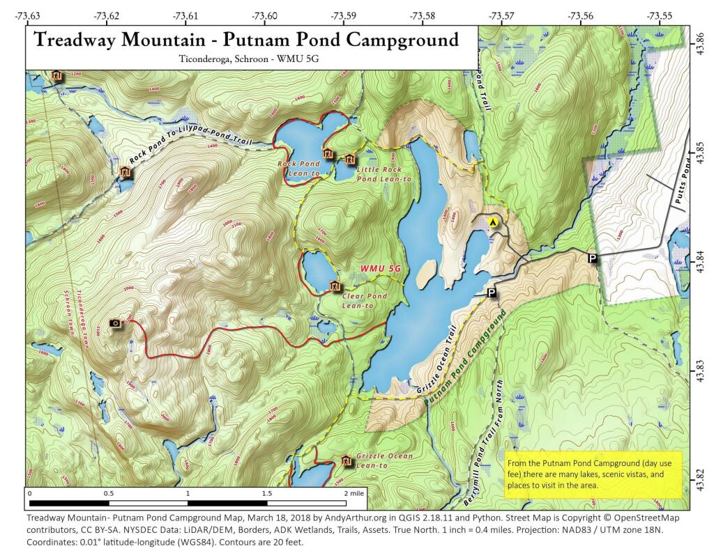
5 |
Pharaoh Lake Wilderness |
Berrymill Pond Lean-To |
Digitized From National Geographic Map |
43.8384100119,
-73.5916749102 |
5 |
Pharaoh Lake Wilderness |
Clear Pond Lean-To |
Digitized From National Geographic Map |
43.8412911595,
-73.6316882519 |
5 |
Pharaoh Lake Wilderness |
Crab Pond Lean-To |
Digitized From National Geographic Map |
43.8223693677,
-73.5906397879 |
5 |
Pharaoh Lake Wilderness |
Grizzle Ocean Lean-To |
Digitized From National Geographic Map |
43.8492027141,
-73.6180024108 |
5 |
Pharaoh Lake Wilderness |
Lillypad Pond Lean-To |
Digitized From National Geographic Map |
43.8500028762,
-73.5895397847 |
5 |
Pharaoh Lake Wilderness |
Little Rock Pond Lean-To |
Digitized From National Geographic Map |
43.8405296779,
-73.6501782303 |
5 |
Pharaoh Lake Wilderness |
Oxshoe Pond Lean-To |
Digitized From National Geographic Map |
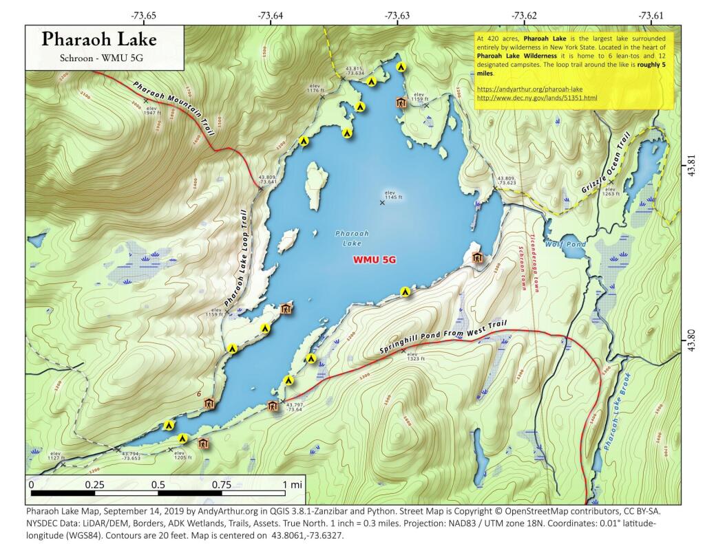
43.7945783128,
-73.6458567831 |
5 |
Pharaoh Lake Wilderness |
Pharaoh Lake #1 Lean-To |
Digitized From National Geographic Map |
43.7966550547,
-73.6403349616 |
5 |
Pharaoh Lake Wilderness |
Pharaoh Lake #2 Lean-To |
Digitized From National Geographic Map |
43.8049450672,
-73.6240085371 |
5 |
Pharaoh Lake Wilderness |
Pharaoh Lake #3 Lean-To |
Digitized From National Geographic Map |
43.8049450672,
-73.6240085371 |
5 |
Pharaoh Lake Wilderness |
Pharaoh Lake #3 Lean-To |
Digitized From National Geographic Map |
43.8121074537,
-73.6282851829 |
5 |
Pharaoh Lake Wilderness |
Pharaoh Lake #4 Lean-To |
Digitized From National Geographic Map |
43.8021964679,
-73.6391689125 |
5 |
Pharaoh Lake Wilderness |
Pharaoh Lake #5 Lean-To |
Digitized From National Geographic Map |
43.8505590671,
-73.5922949091 |
5 |
Pharaoh Lake Wilderness |
Rock Pond Lean-To |
Digitized From National Geographic Map |
43.8581713271,
-73.626483712 |
5 |
Pharaoh Lake Wilderness |
Tubmill Marsh Lean-To |
Digitized From National Geographic Map |
44.3961331068,
-74.3704212658 |
5 |
Saint Regis Canoe Area |
Fish Pond Site 2 Lean-To |
Saint Regis Mountain |
44.3913013571,
-74.3658071555 |
5 |
Saint Regis Canoe Area |
Fish Pond Site 5 Lean-To |
New Lean-To Built Sept. 2010,Relocated Further From Water |
44.3808655111,
-74.3200340382 |
5 |
Saint Regis Canoe Area |
St. Regis Pond Site 3 Lean-To |
Lean-To Too Close To Water, Need To Move Back When Major Work Is Needed |
44.3250945507,
-74.3498966646 |
5 |
Saranac Lakes Wild Forest |
Follensby Clear Lean-To |
|
44.2866574735,
-74.1626018103 |
5 |
Saranac Lakes Wild Forest |
Kiwasa Lake Site 3 Lean-To |
|
44.3322955804,
-73.9566258523 |
5 |
Saranac Lakes Wild Forest |
Lake Placid Site 2 Lean-To |
Lake Placid |
44.3325954268,
-73.9566801194 |
5 |
Saranac Lakes Wild Forest |
Lake Placid Site 3 Lean-To |
Lake Placid |
44.2253525405,
-74.3803783852 |
5 |
Saranac Lakes Wild Forest |
Raquette Lean-To |
Built In 2013 Relocated From Trombley Landing Site |
44.3092299998,
-74.1801499997 |
5 |
Saranac Lakes Wild Forest |
Saranac Islands Site 2 Lean-To |
|
44.2890999998,
-74.2172199999 |
5 |
Saranac Lakes Wild Forest |
Saranac Islands Site 45 Lean-To |
|
44.2666999994,
-74.2447999995 |
5 |
Saranac Lakes Wild Forest |
Saranac Islands Site 63 Lean-To |
|
44.2729500004,
-74.27398 |
5 |
Saranac Lakes Wild Forest |
Saranac Islands Site 81 Lean-To |
|
44.2878799998,
-74.2885399997 |
5 |
Saranac Lakes Wild Forest |
Saranac Islands Site 87 Lean-To |
|
44.2287716477,
-74.3755334312 |
5 |
Saranac Lakes Wild Forest |
Trombley Landing Lean-To |
|
44.3028866826,
-74.3026336593 |
5 |
Saranac Lakes Wild Forest |
Upper Saranac Lake Lean-To |
|
43.8161997506,
-74.6446678086 |
5 |
Sargent Ponds Wild Forest |
Big Island Lean-To 1 |
|
43.8170896757,
-74.6432509546 |
5 |
Sargent Ponds Wild Forest |
Big Island Lean-To 2 |
|
43.8171339137,
-74.6437800321 |
5 |
Sargent Ponds Wild Forest |
Big Island Lean-To 3 |
|
43.8707715776,
-74.6285067054 |
5 |
Sargent Ponds Wild Forest |
Boucher Point Lean-To #1 |
|
43.8710064606,
-74.6281079204 |
5 |
Sargent Ponds Wild Forest |
Boucher Point Lean-To #2 |
|
43.8707202965,
-74.629171869 |
5 |
Sargent Ponds Wild Forest |
Boucher Point Lean-To #3 |
|
44.1027442039,
-74.321862706 |
5 |
Sargent Ponds Wild Forest |
Deep Hole Lean-To |
|
43.9262175397,
-74.4753958672 |
5 |
Sargent Ponds Wild Forest |
Deerland Carry # 2 Lean-To |
Fair Condition |
43.9257807189,
-74.4758457554 |
5 |
Sargent Ponds Wild Forest |
Deerland Carry #1 Lean-To |
Fair Condition |
43.9028470717,
-74.5480629364 |
5 |
Sargent Ponds Wild Forest |
Forked Lake Lean-To |
|
44.0814068183,
-74.3358291461 |
5 |
Sargent Ponds Wild Forest |
Long Lake Nw Lean-To #1 |
|
44.0825043385,
-74.3339145725 |
5 |
Sargent Ponds Wild Forest |
Long Lake Nw Lean-To #2 |
|
43.8593314968,
-74.5626945075 |
5 |
Sargent Ponds Wild Forest |
Lower Sargents Pond Lean-To |
Fair Condition |
43.8794136061,
-74.6060523536 |
5 |
Sargent Ponds Wild Forest |
Outlet Bay Lean-To |
Hit By Tree, 2011 |
43.9066458928,
-74.5025901551 |
5 |
Sargent Ponds Wild Forest |
Pinebrook Lean-To |
Fair Condition |
43.8368984989,
-74.5352656022 |
5 |
Sargent Ponds Wild Forest |
Utowana Lake Lean-To |
|
44.3317122951,
-73.8997103538 |
5 |
Sentinel Range Wilderness |
Copperas Pond Lean-To |
|
43.2171873383,
-74.3641178087 |
5 |
Shaker Mountain Wild Forest |
Chase Lake Lean-To |
|
43.1885867657,
-74.4310218123 |
5 |
Shaker Mountain Wild Forest |
Holmes Lake Lean-To |
|
43.6161332228,
-74.1506253912 |
5 |
Siamese Ponds Wilderness |
E. Sacandaga River Lean-To |
|
43.7007731961,
-74.1581732825 |
5 |
Siamese Ponds Wilderness |
Hour Pond Lean-To |
|
43.7278247362,
-74.2012685562 |
5 |
Siamese Ponds Wilderness |
John Pond Lean-To |
|
43.6775543215,
-74.1916025718 |
5 |
Siamese Ponds Wilderness |
Puffer Pond #1 Lean-To |
|
43.6765395437,
-74.1997399401 |
5 |
Siamese Ponds Wilderness |
Puffer Pond #2 Lean-To |
|
43.3974135952,
-74.45529759 |
5 |
Silver Lake Wilderness |
Hamilton Lake Stream #1 Lean-To |
|
43.3426710732,
-74.4562907856 |
5 |
Silver Lake Wilderness |
Mud Lake Lean-To |
|
43.2919354568,
-74.4237351677 |
5 |
Silver Lake Wilderness |
Silver Lake Lean-To |
|
44.4897002134,
-73.8614267379 |
5 |
Taylor Pond Wild Forest |
North Shore Taylor Pond Lean-To |
Managed By Operations |
44.4776887718,
-73.881283087 |
5 |
Taylor Pond Wild Forest |
Northwest Shore Taylor Pond Lean-To |
Managed By Operations |
44.3997973549,
-73.5145569962 |
5 |
Taylor Pond Wild Forest |
Poke-O-Moonshine Summit Lean-To |
|
44.4828880086,
-73.8537772441 |
5 |
Taylor Pond Wild Forest |
South East Taylor Pond Lean-To |
Managed By Operations |
43.9326741166,
-73.9690844017 |
5 |
Vanderwhacker Mountain Wild Forest |
Cheney Pond Lean-To |
|
43.8387348153,
-73.9856219154 |
5 |
Vanderwhacker Mountain Wild Forest |
Stony Pond Lean-To |
|
43.6259693968,
-74.5492715037 |
5 |
West Canada Lake Wilderness |
Beaver Pond (AKA Cedar Lakes Lean-To #2) |
|
43.6787448835,
-74.4954982188 |
5 |
West Canada Lake Wilderness |
Carry Lean-To |
|
43.628125665,
-74.5404732399 |
5 |
West Canada Lake Wilderness |
Cedar Lakes #1 Lean-To |
|
43.6084635843,
-74.559724172 |
5 |
West Canada Lake Wilderness |
Cedar Lakes #3 Lean-To |
|
43.6524139144,
-74.4903803529 |
5 |
West Canada Lake Wilderness |
Colvin Brook Lean-To |
|
43.5968984709,
-74.5316653645 |
5 |
West Canada Lake Wilderness |
Pillsbury Lake Lean-To |
|
43.5807608964,
-74.576533363 |
5 |
West Canada Lake Wilderness |
Sampson Lake Lean-To |
|
43.5872448097,
-74.6215788384 |
5 |
West Canada Lake Wilderness |
South Lake Lean-To |
|
43.5272841126,
-74.6099246975 |
5 |
West Canada Lake Wilderness |
Spruce Lake #1 Lean-To |
|
43.5346306298,
-74.6080858031 |
5 |
West Canada Lake Wilderness |
Spruce Lake #2 Lean-To |
|
43.5371297279,
-74.608209628 |
5 |
West Canada Lake Wilderness |
Spruce Lake #3 Lean-To |
|
43.4527175892,
-74.5822815394 |
5 |
West Canada Lake Wilderness |
T Lake Lean-To |
|
43.586987614,
-74.613997971 |
5 |
West Canada Lake Wilderness |
West Canada Creek Lean-To |
|
43.5931622288,
-74.6268866843 |
5 |
West Canada Lake Wilderness |
West Lake #1 Lean-To |
|
43.5970642572,
-74.6231056496 |
5 |
West Canada Lake Wilderness |
West Lake #2 Lean-To |
|
43.5102617091,
-74.0492883971 |
5 |
Wilcox Lake Wild Forest |
Lizard Pond Lean-To |
Digitized From National Geographic Map |
43.3363734227,
-74.2173211966 |
5 |
Wilcox Lake Wild Forest |
Murphy Lake Lean-To |
Digitized From National Geographic Map |
43.396075559,
-74.1532214824 |
5 |
Wilcox Lake Wild Forest |
Wilcox Lake #1 Lean-To |
Digitized From National Geographic Map |
43.39859675,
-74.1554639493 |
5 |
Wilcox Lake Wild Forest |
Wilcox Lake #2 Lean-To |
Digitized From National Geographic Map |
44.0021452737,
-74.7756817712 |
5 |
William C. Whitney Wilderness |
Lake Lila # 7 Lean-To |
|
44.4244015852,
-73.8486868866 |
5 |
Wilmington Wild Forest |
Cooper Kill Lean-To |
Too Close To Water, Need To Replocate, Do Not Repair |
44.1070894301,
-75.0674448544 |
6 |
Aldrich Pond Wild Forest |
Streeter Lake Lean-To |
Wood |
43.7434886212,
-74.8776068003 |
6 |
Alger Island Campground |
Campsite # 01 |
|
43.7443528827,
-74.8771318496 |
6 |
Alger Island Campground |
Campsite # 02 |
|
43.7456011181,
-74.8768832894 |
6 |
Alger Island Campground |
Campsite # 03 |
|
43.7466942129,
-74.8745145576 |
6 |
Alger Island Campground |
Campsite # 04 |
|
43.746535972,
-74.8735980503 |
6 |
Alger Island Campground |
Campsite # 05 |
|
43.7467703384,
-74.8722666576 |
6 |
Alger Island Campground |
Campsite # 06 |
|
43.7465482669,
-74.8718037808 |
6 |
Alger Island Campground |
Campsite # 07 |
|
43.7458848539,
-74.8729191925 |
6 |
Alger Island Campground |
Campsite # 08 |
|
43.7454701717,
-74.8727721949 |
6 |
Alger Island Campground |
Campsite # 09 |
|
43.7450840439,
-74.8725955649 |
6 |
Alger Island Campground |
Campsite # 10 |
|
43.744783668,
-74.8724088972 |
6 |
Alger Island Campground |
Campsite # 11 |
|
43.7441622435,
-74.8727256743 |
6 |
Alger Island Campground |
Campsite # 12 |
|
43.7440135576,
-74.8739878218 |
6 |
Alger Island Campground |
Campsite # 13 |
|
43.7431429387,
-74.875172598 |
6 |
Alger Island Campground |
Campsite # 14 |
|
43.7428736074,
-74.8760835968 |
6 |
Alger Island Campground |
Campsite # 15 |
|
43.6000735406,
-75.0530032053 |
6 |
Black River Wild Forest |
Bear Lake Lean-To |
|
43.5245079024,
-75.0409215605 |
6 |
Black River Wild Forest |
Chub Pond #1 Lean-To |
Rehabbed In 2008 |
43.5298225654,
-75.0424937056 |
6 |
Black River Wild Forest |
Chub Pond #2 Lean-To |
Built By Lean-To Permit 1963, Taken Care Of By Plumley Family |
43.5537469236,
-75.059377614 |
6 |
Black River Wild Forest |
Gull Lake Lean-To |
|
43.5341150034,
-74.9280935302 |
6 |
Black River Wild Forest |
Lean-To |
|
43.6299248982,
-75.0362877527 |
6 |
Black River Wild Forest |
Remsen Falls Lean-To |
Rehabbed In 2008 |
43.5589136946,
-75.0030576033 |
6 |
Black River Wild Forest |
Sand Lake Falls Lean-To |
Rehabbed In 2008 |
43.5998849075,
-75.0203817469 |
6 |
Black River Wild Forest |
Woodhull Lake Lean-To |
Rehabbed In 2008, Double Sized Lean-To |
43.6520754244,
-75.0592470923 |
6 |
Black River Wildforest |
Nelson Lake Trail Lean-To |
|
43.3445446485,
-75.6722203255 |
6 |
Cobb Brook State Forest |
Leanto |
|
44.1990987752,
-74.8148790735 |
6 |
Cranberry Lake Wild Forest |
Bear Mountain Lean-To |
|
44.2105729246,
-74.7181527787 |
6 |
Cranberry Lake Wild Forest |
Burntbridge Pond Lean-To |
|
44.1533999108,
-74.8840290725 |
6 |
Cranberry Lake Wild Forest |
Ranger School Lean-To |
Campsite 41 Aka Inlet Flow Lean-To |
44.0529214425,
-74.9471939334 |
6 |
Five Ponds Wilderness |
Big Shallow Lean-To |
Cs 30 |
44.0528916324,
-75.0090580588 |
6 |
Five Ponds Wilderness |
Cage Lake Lean-To |
|
44.0931113064,
-74.8498397365 |
6 |
Five Ponds Wilderness |
Cowhorn Pond Lean-To |
|
44.1123581654,
-74.8914922468 |
6 |
Five Ponds Wilderness |
Janacks Landing Lean-To |
With Full Sized Privy |
44.0474525004,
-74.9526919257 |
6 |
Five Ponds Wilderness |
Little Shallow Lean-To |
Cs 30 |
44.1198328093,
-74.8454890242 |
6 |
Five Ponds Wilderness |
Olmstead Pond Lean-To |
With Full Sized Privy |
44.0689970407,
-74.9112845696 |
6 |
Five Ponds Wilderness |
Oswegatchie River Site 13 Lean-To |
Cs 13 Lt |
44.0688665373,
-74.9093532798 |
6 |
Five Ponds Wilderness |
Oswegatchie River Site 15 Lean-To |
Cs 15 Lt |
44.0746275016,
-74.9613775006 |
6 |
Five Ponds Wilderness |
Oswegatchie River Site 34 Lean-To |
Cs 34 Lt |
44.0843538607,
-74.9687312803 |
6 |
Five Ponds Wilderness |
Oswegatchie River Site 38 Lean-To |
Cs 38 Lt |
44.0154640897,
-75.0054753701 |
6 |
Five Ponds Wilderness |
Sand Lake Lean-To |
Cs 30 |
43.9284894776,
-74.9448704212 |
6 |
Five Ponds Wilderness |
Trout Pond Lean-To |
|
43.9284894776,
-74.9448704212 |
6 |
Five Ponds Wilderness |
Trout Pond Lean-To |
|
44.0299676783,
-74.9801386129 |
6 |
Five Ponds Wilderness |
Wolf Lake Lean-To |
Cs 30 |
43.7029255425,
-75.0960024266 |
6 |
Haderondah |
Middle Branch Lake Lean-To |
|
43.6859486954,
-75.0986138399 |
6 |
Haderondah |
Middle Settlement Lake Lean-To |
|
44.1511613292,
-74.5657606156 |
6 |
Horseshoe Lake Wild Forest |
Black Bay Lean-To |
Checked 11/2015 |
44.196860294,
-74.5121752893 |
6 |
Horseshoe Lake Wild Forest |
Eagle Landing Lean-To |
Tupper Lake Site #5 |
43.8235350455,
-75.1693122081 |
6 |
Independence River Wild Forest |
Panther Pond Lean-To |
|
43.7083935125,
-75.14645298 |
6 |
Independence River Wild Forest |
Pine Lake Lean-To |
|
43.8089062032,
-75.474955964 |
6 |
Lowville Demonstration Area |
Lowville Forestry Demonstration Area |
|
43.8558345419,
-74.804220953 |
6 |
Pigeon Lake Wilderness |
Andes Creek Lean-To |
|
43.8575116443,
-74.8252446695 |
6 |
Pigeon Lake Wilderness |
Gull Lake Lean-To |
|
43.8764050748,
-74.7655286668 |
6 |
Pigeon Lake Wilderness |
Lower Sister Lake Lean-To |
|
43.8421644493,
-74.8055993839 |
6 |
Pigeon Lake Wilderness |
Russian Lake Lean-To |
|
43.8139160683,
-74.7983685471 |
6 |
Pigeon Lake Wilderness Area |
Queer Lake Lean-To |
Campsite With Lean-To |
43.8348742486,
-75.8607286637 |
6 |
Tug Hill State Forest |
Electric Loop Lean-Too |
Wooden Lean-Too Built In 1982, By Steve Wood Troop 7 |
44.3578220602,
-75.3160008277 |
6 |
Wolf Lake State Forest |
Beaver Flow Lean-To |
Beaver Flow Leanto |
44.3242717044,
-75.3337383742 |
6 |
Wolf Lake State Forest |
Huckleberry Lake Lean-To |
Huckleberry Lake Leanto |
44.3322757137,
-75.3211717792 |
6 |
Wolf Lake State Forest |
Moon Pond Lean-To |
Moon Lake Leanto |
44.3322757137,
-75.3211717792 |
6 |
Wolf Lake State Forest |
Moon Pond Lean-To |
Moon Lake Leanto |
44.3322757137,
-75.3211717792 |
6 |
Wolf Lake State Forest |
Moon Pond Lean-To |
Moon Lake Leanto |
44.3322757137,
-75.3211717792 |
6 |
Wolf Lake State Forest |
Moon Pond Lean-To |
Moon Lake Leanto |
44.3363136709,
-75.313863327 |
6 |
Wolf Lake State Forest |
Wolf Lake Lean-To |
Wolf Lake Leanto |
42.746653083,
-75.3797255193 |
7 |
Charles E. Baker State Forest |
Trail 17 Lean-To |
Primitive Campsite With Fire Pit |
42.7627233838,
-75.379619514 |
7 |
Charles E. Baker State Forest |
Woodland Pond Lean-To |
Primitive Campsite With Hore Tie Rail And Fire Pit |
42.3270424066,
-76.4900608723 |
7 |
Danby State Forest |
Chestnut Lean-To |
|
42.3176423354,
-76.4225442513 |
7 |
Danby State Forest |
Tamarack Lean-To |
|
42.8201846305,
-75.8591052772 |
7 |
Deruyter State Forest |
Deruyter Lean-To |
|
42.4228873052,
-75.7674346807 |
7 |
Genegantslet State Forest |
Top Ten Lean-To |
20′ X 20′ Log Cabin |
42.4728525684,
-76.1787322193 |
7 |
Kennedy State Forest |
Foxfire Lean-To |
|
42.4458019158,
-75.7015069607 |
7 |
Ludlow Creek State Forest |
Ludlow Creek Lean-To |
8′ X 10′ Constructed 2002 |
42.723126977,
-75.8709545002 |
7 |
Mariposa State Forest |
Mariposa Finger Lakes Lean-To |
|
42.7672022335,
-76.0112561891 |
7 |
Morgan Hill State Forest |
Morgan Hill Lean-To |
|
42.6423073773,
-75.7437663179 |
7 |
Perkins Pond State Forest |
Flt Lean-To Lean-To |
|
42.3905962266,
-76.2718006242 |
7 |
Robinson Hollow State Forest |
Kimme Lean-To |
|
42.3276442724,
-76.3290355678 |
7 |
Shindagin Hollow State Forest |
Shindagin Lean-T0 |
Scheduled For Replacement In 2004 |
42.5122011517,
-76.1208238604 |
7 |
Tuller Hill State Forest |
Woodchuck Hollow Lean-To |
Rebuilt In 2002 From Local State Forest Red Pine, Built By Volunteers From Suny Cortland |
42.6060629372,
-75.4671141039 |
7 |
Whaupaunaucau State |
Leanto |
|
42.3132130609,
-77.5663734584 |
8 |
Burt Hill State Forest |
On Finger Lake Trail Lean-To |
|
42.625051213,
-77.3586638233 |
8 |
High Tor Wma |
High Tor North Lean-To |
Campsite With Stone Firepit And Privy Updated By Emily Bonk Forest Tech |
42.6146971076,
-77.3661109424 |
8 |
High Tor Wma |
High Tor South Lean-To |
Campsite With Firepit And Privy Updated By Emily Bonk Forest Tech |
42.0965007548,
-77.1964378403 |
8 |
Mccarthy Hill State Forest |
Mccarthy Hill Leanto |
Built By Fltc 2012 |
42.2891155929,
-77.1188809327 |
8 |
South Bradford State Forest |
Moss Hill Lean-To |
|
42.3730816642,
-76.9554800047 |
8 |
Sugar Hill State Forest |
Buck Settlement Lean-To |
Built 2006 By Fltc |
42.369515888,
-77.0127591279 |
8 |
Sugar Hill State Forest |
Parks Hollow Lean-To |
|
42.3690917205,
-77.0130036276 |
8 |
Sugar Hill State Forest |
Parks Hollow Lean-To |
Log Built 2011 |
42.3822533326,
-77.0026799995 |
8 |
Sugar Hill State Forest |
The Twin Lean-To’s |
2 Lean-To At This Location |
42.3898077706,
-76.9725898373 |
8 |
Sugar Hill State Forest |
Vanzandt Lean-To |
|
42.3340314562,
-78.532889311 |
9 |
Boyce Hill State Forest |
Flt Lean To |
Log Lean To Built In 2012 By Flt Club |
42.53472215,
-73.9623319605 |
|
|
Cabins |
|
42.3492343019,
-77.8075299409 |
|
|
Flt |
|
