Search Results for: "Map:" Rain

Most Common Heating Fuel

Most Common Heating Fuel

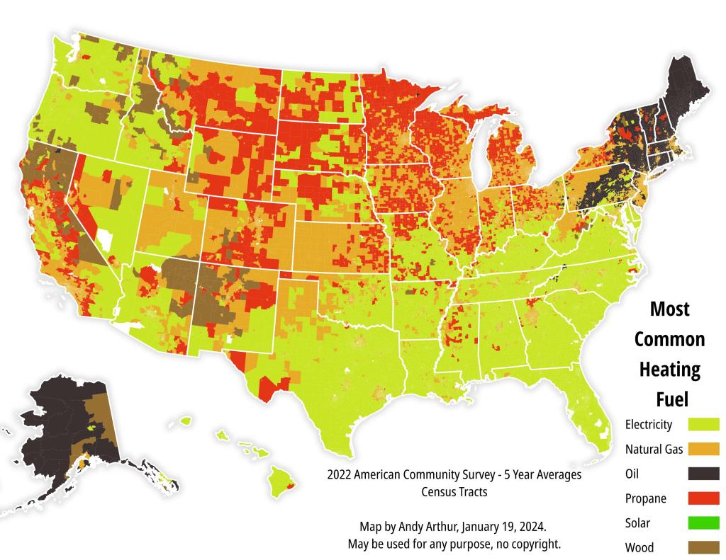
This map is based on a very popular Washington Post map of a few years back. Basically for all 84,000 or so US Census Tracts, it compares the method most common for heating.
 
As New Yorkers, we might think it's odd that electric heating is the most popular way to heat houses in great parts of country, and it's not just in warm climate south -- electricity is popular where electricity is cheap, like in the Northwest and much of Appalachia.
 
Oil is odd fuel, not widely used outside of the rural areas in the Northeast and Alaska. Propane dominates the rural Midwest, where it is cheap due to farms using to dry corn.

Heating with fuel oil, which is essentially dyed diesel, seems like an odd choice. Oil is expensive, but also is electricity in the Northeast.

In the 1940s through the 1970s, there was a big push to retire both coal power plants and coal heating for reasons of pollution and convenience, and oil seemed like a good drop in replacement, when oil was cheap. But the northeast relying on oil so heavily for power generation, caused electricity to spike in 1970s, which ironically caused some people to swap out electricity for fuel oil. Natural gas supply has traditionally been constrained in New England, which is another reason why the Northeast likes oil so much.


Schodack Island Backwaters

Near Hells Gate at Schodack Island State Park, with the Schodack Creek to flowing muddy after a rain storm.

Waterloo, home of the first Memorial Day

The story of Memorial Day begins in the summer of 1865, when a prominent local druggist, Henry C. Welles, mentioned to some of his friends at a social gathering that while praising the living veterans of the Civil War it would be well to remember the patriotic dead by placing flowers on their graves. Nothing resulted from this suggestion until he advanced the idea again the following spring to General John B. Murray. Murray, a civil war hero and intensely patriotic, supported the idea wholeheartedly and marshalled veterans’ support. Plans were developed for a more complete celebration by a local citizens’ committee headed by Welles and Murray.

On May 5, 1866, the Village was decorated with flags at half mast, draped with evergreens and mourning black. Veterans, civic societies and residents, led by General Murray, marched to the strains of martial music to the three village cemeteries. There impressive ceremonies were held and soldiers’ graves decorated. One year later, on May 5, 1867, the ceremonies were repeated. In 1868, Waterloo joined with other communities in holding their observance on May 30th, in accordance with General Logan’s orders. It has been held annually ever since.

Waterloo held the first formal, village wide, annual observance of a day dedicated to honoring the war dead. On March 7, 1966, the State of New York recognized Waterloo by a proclamation signed by Governor Nelson A. Rockefeller. This was followed by recognition from Congress of the United States when the House of Representatives and the Senate unanimously passed House Concurrent Resolution 587 on May 17th and May 19th, 1966 respectively. This reads in part as follows: “Resolved that the Congress of the United States, in recognition of the patriotic tradition set in motion one hundred years ago in the Village of Waterloo, NY, does hereby officially recognize Waterloo, New York as the birthplace of Memorial Day…”
http://waterloony.com/memorial-day/history/ 

Stockbridge, VT

Stockbridge is a town in Windsor County, Vermont, in the Woodstock-Quechee region. The town covers approximately 28,300 acres, or 45.41 square miles. The population of Stockbridge was 718 at the 2020 census. Stockbridge is bordered by Barnard to the east, Bridgewater and Sherburne to the south, Bethel and Rochester to the north, and Pittsfield to the west. Stockbridge is located in the physiographic region known as the Intermountain Valleys and foothills of the Green Mountains. The area is characterized by mountainous terrain, narrow valleys and a few peaks above 2,500 feet.

Lodi, NY

That quaint Finger Lakes village just north of National Forest that received 9 inches of rain in less then a half hour during a summer thunderstorm in 2018, leading to cars floating down Main Street.

Voorheesville – Year of Building Construction

It's interesting to see the various waves of building construction in village from county tax maps -- 1880s and 1890s railroad construction along Voorheesville Avenue near the train station, then a big development in the late 1960s and early 1970s, another development in the late 1970s, and then Edinburgh Court and Country Club development of the late 2010s,