Search Results for: photo limbs 2

October 15, 2015 update

I decided to leave West Virgina on Tuesday, in part because I wanted to stay at a developed campground where I could get a shower, and because I was getting awful tired of the narrow, steep roads of West Virgina. Iโ€™m sure not every road is awful in West Virginia, but it sure seems like I have been driving up them โ€“ from Dolly Sods Road to Spruce Mountain Road โ€“ to say nothing of the somewhat larger but much heavier traffic of US 33 as it crosses Judyโ€™s Pass to Franklinton then again over Shenandoah Mountain. I just hate the steep climbs, the descending in low gear, and the traffic wanting to blast pass.

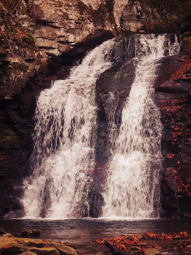
Shenandoah National Park was on my list to see. I figured if I was going to be in West Virginia, I better also swing east to Skyline Drive and the Shenandoah National Park in Virginia. I was generally heading that way from Grandy Creek, the other alternative was to head south to WV 22 and out that way, but I wanted to see Spruce Mountain, which there is a road that takes you up 4,823 feet to the highest point in West Virginia. You certainly canโ€™t drive that high anywhere in New York on a public road, and only the highest of high peaks take you up there. The summit of Spruce Mountain is remarkably beautiful and mostly undeveloped besides a narrow paved road that takes you to the top, a small picnic area and observation platform. The drive down Spruce Mountain was so steep though.

US 33 was quite the climb and descent over the two mountain ranges from where I was to Virginia. It was steep but once you reached the Shenandoah Valley, US 33 cuts through a beautiful section of the George Washington National Forest without a bend  in miles. You quickly forget the awful drive you just made over Shenandoah Mountain. To make matters worst, US 33 was being repaved over Shenandoah Mountain, so I ended up getting stuck at the bottom weighting for the pilot car to bring me and a long line of traffic up the three miles up it on the West Virginia side. The Virginia side was just as as steep, but the lanes were wider and despite the hairpin turns,seemed much more navigable.

Harrisonburg, VA is a pretty large city. I had no idea until I arrived downtown and had to fight traffic on six lane roads. The Shenandoah Valley was pretty with a lot of chicken farms and some dairies, but this general area was also rapidly suburbanizing, with houses abutting farms. Iโ€™m sure that leads to a strained relationship at times between the farms and the suburbanites. Smelled somewhat like farm country, not unlike around Lowville or any of the great agricultural valleys in New York. Harrisonburg sucked to drive through, but once you got 5 miles out of town it was a four lane road with occasional traffic lights and a fairly heavily volume, but eventually it became open, rolling country. US 33 drops down to 2 lanes with occasional passing lanes as you entered the park. I would like to get down and see more of the Shenandoah Valley away from the city. Maybe tomorrow or Friday.

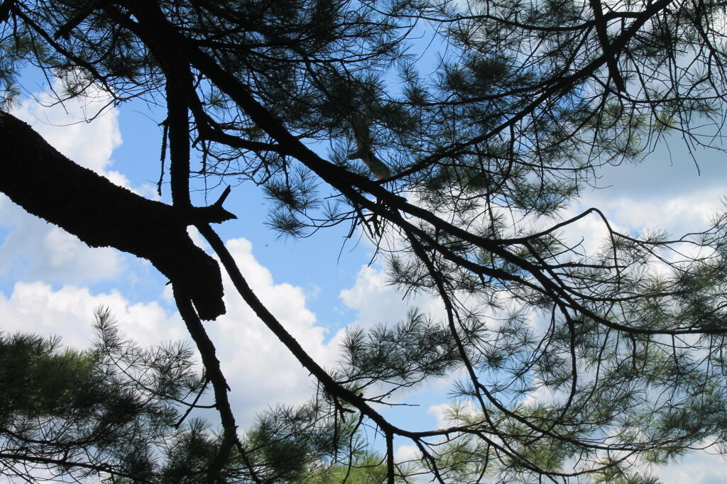
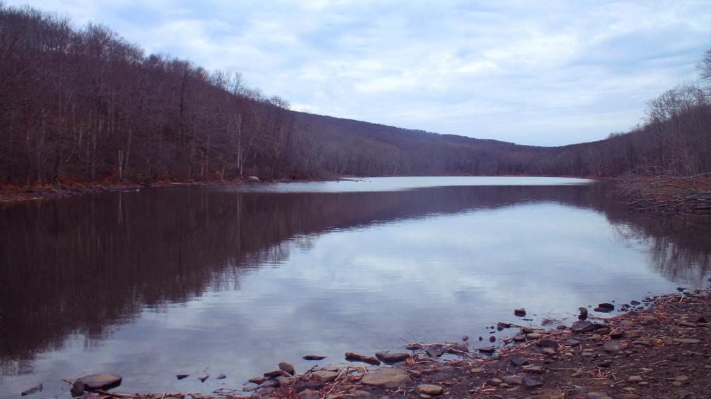
When I first arrived at Shenandoah National Park I was under-impressed, as the section of Skyline Drive  north of US 33 isnโ€™t immediately impressive despite the overviews. The wonderful weather of Tuesday morning had turned to clouds as I headed east into the the front. It might have been sunny and beautiful in West Virginia, but by the time I was east in Shenandoah Valley it had gotten cloudy and hazy. The Shenandoah Valley also suffers from a major air pollution problem, which is somewhat less in West Virginia in the very rural area around Spruce Mountain. The wilderness area around Spruce Mountain and Dolly Sands is very impressive, some of the views at Shenandoah were less impressive.
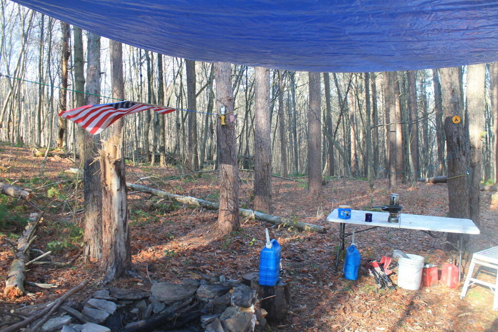
I decided to camp at Matthewโ€™s Arm Concentrated Camping Operation, the farthest north campground along the parkway โ€“ 21 miles from the northern start of Skyline Drive. It was a nice campground although it was fairly rustic. It has flush toilets and running water in the bathrooms, but it refill water containers, you had to drive to the trailer dump station and water filling area (separate faucets, obviously). One thing this campground lacked was showers, which was a disappointment. But they recommended you visit the pay showers 15 miles down the road at Big Meadows. This campground was $15 a night with no taxes or fees, it did not have electricity in the campground. They had heated bathrooms with running water. No hot water at Matthewโ€™s Arm but they did have hot water at Loft Mountain. I had dinner and a few beers and was in bed by 9 PM. They openly allow (and sell alcohol) at the Shenandoah National Park campgrounds which is kind of nice. Still having neighbors and having to keep the music down and being brief with idling the engine to keep the batteries charged, is less nice.

I had to get up early to go to the bathroom, and ultimately decided to get up around 6:45 AM to drive over to one of the overlooks to watch the sun rise.
While a somewhat cloudy morning, it was a beautiful start to the day. Broke camp around 9:30 AM and started south on the parkway, stopping at several of the overlooks, then when I got cellphone service, uploaded some photos to share with people, along with previous nights posts. Stopped at Big Meadows Visitors Center and also at the showers at Big Meadows around noontime.

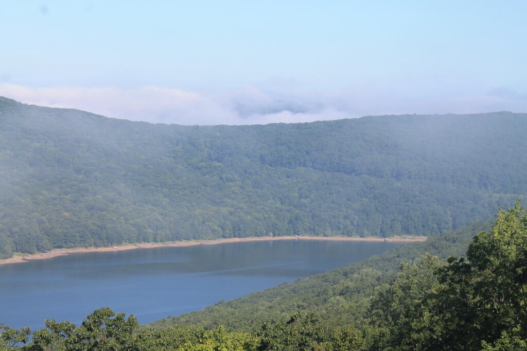
In the nicer weather, spending more time on the parkway, showed how beautiful many of the views are along the parkway. The haze wasnโ€™t as bad in the clear, drier weather, although still notable across the valley. Some of the overviews from Skyline Drive are remarkably beautiful, others less so. The leaves arenโ€™t peak everywhere, but there is some nice colors showing up in various directions. Got a campsite at the Loft Mountain Concentrated Camping Operation. Picked a site high up on the hill, hoping to get cellphone reception and at least good radio reception. The cellphone reception was pretty marginal from camp, but I did have good radio reception for listening to any local radio station within reason. Watched the sun set from one of the overlooks. I retired to bed around 10 PM. Nice flush toilets, hot water, and heated bathrooms. Showers just down the road.

Todayโ€™s plan is to head further down Skyline Drive until I reach the Blue Ridge Parkway. I will probably go a ways down the Parkway, and hopefully find some place to camp at a campground along it. When I reach Interstate 64 on the Blue Ridge Parkway, I will take that west back to West Virigina and on Friday night camp on at site along one of the roads in West Virigina. From there I will take I-99 in Pennsylvania to Wellsboro and the Grand Canyon Country, overnight there, and return to Albany on Sunday afternoon.

Decending an Unnamed Hill

Part of the gated/snow covered portion of Harvey Mountain Truck Trail, goes around and partially over a small hill, then drops into a ravine, until finally one climbs up Harvey Mountain. The truck trail is not much of a hike, no more 9/10th of a mile and only a 150 foot climb.

Taken on Saturday April 2, 2011 at Harvey Mountain State Forest.

Narrow Snowmobile Trail

As the snowmobile trail climbs the mountain, it narrows and grows progressively steeper. It's not a bad trail for snowshoers, as the snowmobiles must proceed slowly up such a steep mountain.

Taken on Sunday March 7, 2010 at Black Mountain.

Nice morning in the wilderness

A nice morning in the wilderness.

Sitting back listening to the birds, watching as the sun climbs higher in the sky and a beautiful day gets underway. No bugs, just a moth and a dragon fly in the distance pollinating flowers while a red tail hawks soars above. Not a cloud in the sky, deep blue beauty as the sun climbs over the tree line.

Blue Skies

Weekend at Bear Springs Mountain, Delaware Wild Forest, Warren Highlands

Based on the forecast for the long weekend, I decided to head down to the Western Catskills rather then Moose River Plains. It certainly was a bit sunnier, drier, and less snowy then it looks like they got up at Moose Plains. I simply did not another Memorial Day Weekend at Moose Plains, sitting in rain and snow showers.

I ended up heading down to the Western Catskills. Didnโ€™t leave home until after 10 AM, because I was putzing around. So be it. I also had to stop at Walmart to buy another blaze orange hat, for hiking, because I lost mine. I knew it would be hunting season down there, and figured better safe then sorry. The previous night, they didnโ€™t have one at Glenmont Walmart, so had to visit the Decided to head out the Warren Anderson Expressway (I-88) down to NY 10, and take that all the way south to Walton.

Fire Tower

Driving down NY 10, as soon as I reached Summit, you could see a dusting of snow on the summits around. Stopped in Stamford, drove up to Mount Utsaythana. There was a dusting of snow there too, in parts it looked like a winter wonderland. Then it was down to Walton, following NY 10 and the East Branch of Delaware River. Drove through Delhi, a small rural college town. I had been through Delhi years ago, meandering around Stamford, but not in years. Then I went down to Walton, climbed an enormous hill in the truck, and was at the Bear Spring Mountain Wildlife Management Area (aka Public Hunting Grounds).

At Bear Spring Mountain WMA there is a state DEC campground known as Bear Spring Mountain Campground. It consists of two parts, a fully developed campground with hot showers that is open during the summer months near Launt Pond, and the Spring Brook area with stud pends and a pit privy, similar to Charles Baker State Forest. Both areas are a $18 a night in summer, but from October to the end of hunting season, the lower area is free, but the water is shut-off down there. The designated campsites there are crunched together, and there is no privacy, so I canโ€™t imagine itโ€™s much fun camping there, especially with the smell of horses on a hot summerโ€™s afternoon.

By the time I got down there, it was fairly early, so decided to explore a bit. Drove up to Corbett, explored the Corbett Suspension Bridge, and an old chimney from the โ€œacid factoryโ€, which made an acid from tree bark for smokelesss gunpowder. Decided to head back and explore Bear Spring Mountain WMA a bit more, and drove up West Trout Brook Road, past several hunters. There are some limited views from end of East Trout Brook Road, namely at the summit Bear Spring Mountain. There are better views from NY 206, climbing up from Walton, but with few view points. Also explored Beers Brook Road, which had some limited but nice views into the valley below, and Russ Gray Pond.

Bridge Tower

Bear Spring WMA, being a federally-funded public hunting grounds, does not allow camping. The only camping there is those tiny, smashed together developed campgrounds known as the Bear Spring State Campground, operated by the DEC. I decided it was getting late, and I would camp there tonight, especially because it looked like one of campers had packed up, and the only other person around, was a female bow hunter, on far end of the campground. I wasnโ€™t thrilled, as it meant I would have to keep the music down, but at least the campground was deep in the valley, protected from the wind.

It wasnโ€™t a bad night though. The pit privies were kind of gross, but probably not worst then most of the outhouses in the woods. There was surprisingly a lot of wood in woods near the campground. The truck worked well with keeping the lights on, since switching the truckโ€™s radio back to the starting battery and evenly discharging both batteries. The radio shuts off automatically when the starting battery is starting to get a bit low, and Big Redโ€™s DIC says โ€œBattery Low: Start Engine Lowโ€. Previously, with the starting battery at full charge, hooked up to the discharged auxiliary battery, the alternator wouldnโ€™t kick up to full charge, so the auxiliary battery would fail to get fully charged. Now, with the starting battery slightly discharged โ€“ but with enough charge to crank the engine, things kept working well all night long. There was a little bit of sleet in the evening, but nothing major.

Russ Grey Pond

The next morning, I got a slow start. It was drizzling, and I kind of slept in. I didnโ€™t have a tarp set up, which didnโ€™t help. I probably didnโ€™t break camp until 10:30 AM..I was thinking of hiking the NYC DEP trail that overlooks the Pepacton Reservoir, but I ended up turning off onto Holiday Brook Road, and deciding to check out Huggins Lake. Hugging Lake was a nice hike back, following an old woods road back there. There is a campsite down by the lake. Apparently on the ridge above Huggins Lake, there is an old growth forest, but I never got back there.

Then it was off to Mary Smith Road. On Campground Road, one of the cut-over roads, I got to a cover bridge, which had a clearance of 6โ€™6โ€, which is about an inch too low for my pickup truck with the cap and racks on. So I had to turn around, and back track for about 5 miles. That sucked. Stopped and grabed a few pictures. When I got on Mary Smith Road, and back in forest preserve, I was pleasantly surprised to find three roadside campsites on it. I ended up camping at the most used of the sites โ€“ as witnessed by vegetation โ€“ along the Finger Lakes Trail/Mary Smith Trail/Middle Mountain Trail. It was a pretty nice roadside campsite.

About as soon as I scoped out the campsite, I realized it would be a pretty night up there. Despite the mountains on both sides, the north wind was whipping along the col. But I liked the campsite, and there was plenty of trees to hang a tarp up. I starting setting up camp at 2:30 PM โ€“ which was kind of early โ€“ but I figured it was too late to hike Mary Smith Hill (which wasnโ€™t true), but it did start to rain/sleet a bit. Got the tarp up, then the lights strung up and flag up. A heavy sleet squall pounded the col, for a while bad enough I hid out in the cab of the truck. Then I went out, built a fire, and spent sometime listening to a podcast and reading a book about the 1964 World Fair in New York.

The new 60-watt equivalent LED bulb I bought worked real well in the cold, which got down below freezing that night.. But with the bulb focused on the book, it was easy reading and plenty bright. In the cold, the 60-watt equivalent LED bulb was actually brighter then the 100-watt florescent bulb I had at camp, even after fully warming up, because the cold wind made it impossible for the florescent tube to get warm enough to fully atomize the mercury in the fixture.

At times the wind picked up, and it was pretty darn cold, to say the least. I end up putting the fire out cold before bed, to reduce the risk of the fire spreading, and because the tarp partially covered the fire pit, I was afraid it could fall into the fire, and possibly set the truck on fire or cause dripping plastic to fall on it. The fire was out cold, and I went to bed around 10:30 PM. No nightmares.

Mary Smith Hill Roadside Campsite 1

After bedding down, the wind started to whip around. It literally was howling, and the tarp was snapping up and down, making quite a bit of noise. Morning came, and it was beautiful blue skies, but very cold. That was when I first saw car actually pass by on Mary Smith Hill Road โ€“ despite being a through-road, and not a super remote road at that. Had another slow breakfast, and built a small fire to burn up some camp garbage. Usually I donโ€™t start fires in the morning, but I was chilly, and knowing that it may be a while until I got out camping again, I wanted to have a fire.

Once I finally got going, I hiked up Mary Smith Hill to the overlook. It really was a lot less further then I expected, and ha+d some interesting views to the north. Nothing totally breathtaking, but still an interesting short hike of maybe 20 minutes each way. Then I drove over to Russell Brook Falls, making a wrong turn and ending up going through Livingston Manor and the world famous fly fishing town, Roscoe. My impression of Roscoe, was it was a very a long and pokey 30 MPH zone, but with more stores then one would expect in such a rural, small town. I probably should have stopped, but I was burning daylight.

Finally made it to Morton Hill Road, and passed a Game Warden in a unmarked green suburbanite-style Jeep. The only reason I know that, was I saw him outside of the car talking to somebody in full uniform. Morton Hill Road climbs a lot from Roscoe out to where it hits Russell Brook Road. There are three campsites along Russell Brook Road, although in all of them there is a boulder barrier between the campsite and fire pit. One might still be able to use them for a pickup with a camper on them, I guess.

Russell Brook Falls 2

I hiked back to Russell Brook Falls โ€“ a beautiful but relatively unknown set of falls โ€“ at least to non-regulars to that part of state. They are less then quarter mile from the Russell Brook Falls parking area. I stopped and grabbed some pictures. Then, itโ€™s easy hike back to back to Trout Pond, following a gated road 9/10th of a mile from the parking area. There is a slight incline on the road, but nothing to make one break a sweat, even a fat out of shape dude like me, who spends too much time sipping cold buds in the woods. The road is a designated route for people with disabilities โ€“ somebody very strong with a wheel chair could theoretically get back there, or maybe with a CP-4 disabled with an ATV permit.

Back at Trout Pond, there is a campsite on the easterly end, and the gated road continues to the west end of lake. On the west end of the lake, there are two other campsites, spaced a ยผ mile apart, along with two lean-tos. All are designed for those with disabilities. There is also a trout spawning shelter on one of the creeks leading into lake. One of the lean-tos was well equipped โ€“ somebody left behind some nice pots and pans, all cleaned up, and a selection of perfectly good adult beverages and soda along the back wall of the lean-to. Talk about paying it forward to the next person who will use that lean-to โ€“ most certainly a hunter this time of year.

Itโ€™s small game hunting season, heard several small game bullets ring out, while hiking back there. No hunters nearby, as far as I could see, but I did wear plenty of blaze orange. I am sure next week, there will be a lot more hunters back there. Wish them luck. Hiked back to my truck and explored Campbell Mountain Road and Campbell Brook Road, looking for additional roadside campsites, preferably the kind you can back a pickup all the way back to. No such luck. Oh, well.

Trout Pond

Then I drove down NY 30, through the hamlet of Harvard, then East Branch. Took Old Route 17 to Hancock, then poked around the Poconos and the Warren Highlands in Pennsyltucky, before eventually ending up in Susquehanna and Great Bend. The area around Hancock is very mountainous and beautiful. The Warren Highlands were rough, mostly hunting and rural landscape country, with a relatively small amount of farming going on. Lots of open burning going on too โ€“ I love Pennsylvania..

I love that wild country, and everything Pennsylvania. Fueled up, picked up certain Pennsylvania products not legal in New York and/or cheaper then New York, then hopped on I-88/Warren Anderson Expressway, and made a bee-line back to Delmar, stopping only momentarily at the rest stop on I-88. That place was creepy as all hell after dark, and not well lit either. I seriously thought of just taking a piss in some farm

I made it back to Delmar around 7 PM. It was a good adventure. Burned through more gasoline, then I had planned, although on the trip back along I-88, I average 19.9 mpg in my Big Red Silverado pickup, so not complaining.

A long-weekend trip in early November to explore the the Western Catskills.