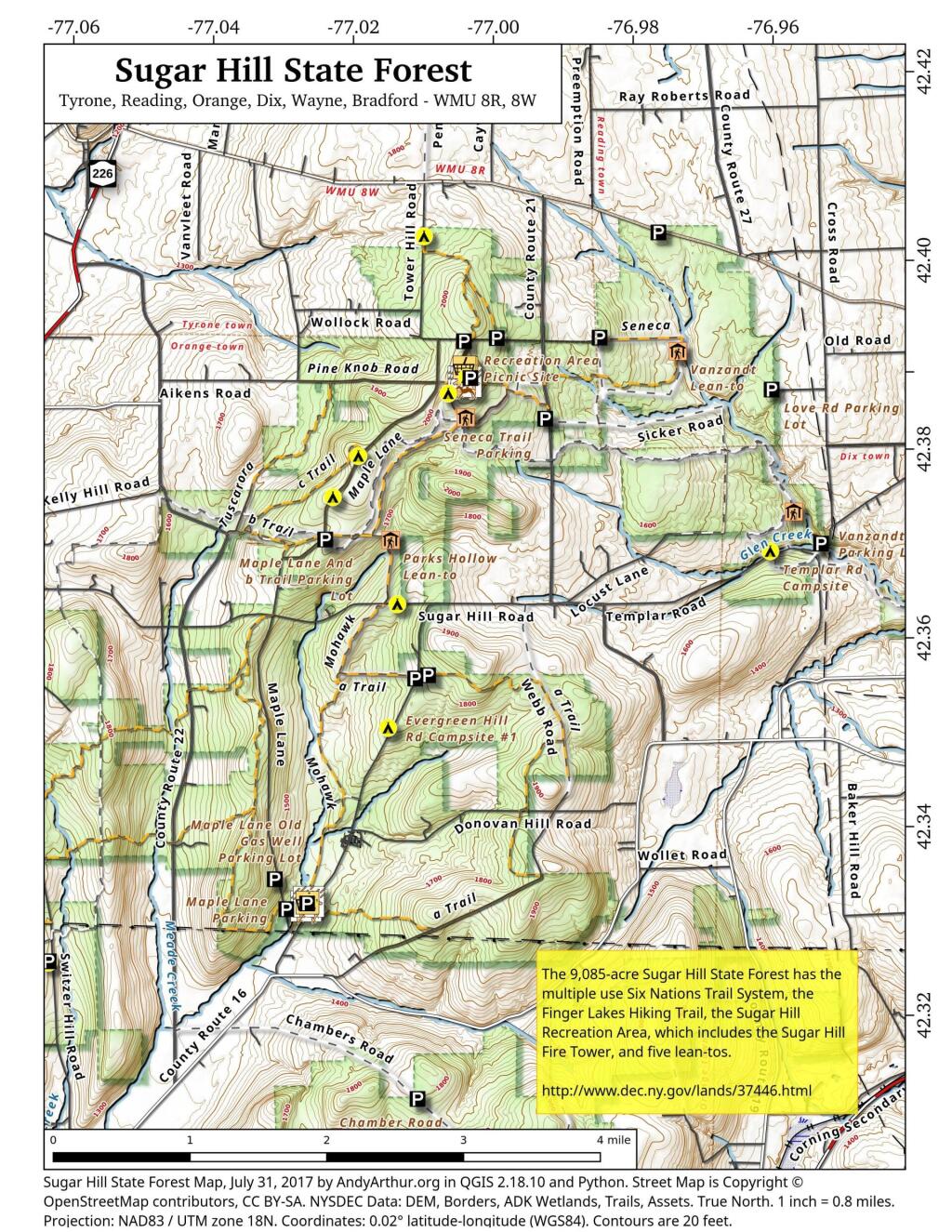
Search Results for: photo campsite 11

Campsites and Lean-Tos in the Pharaoh Lake Wilderness ๐Ÿ•

Name

Asset

Latitude

Longitude

Pharaoh Lake #6 Lean-To

Lean-To

43.7968645799076

-73.6453393000723

Pharaoh Lake #1 Lean-To

Lean-To

43.7945783124509

-73.6458567829525

Pharaoh Lake #2 Lean-To

Lean-To

43.7966550549719

-73.6403349621639

Pharaoh Lake #5 Lean-To

Lean-To

43.8021964675395

-73.6391689121333

Pharaoh Lake #3 Lean-To

Lean-To

43.8049450667974

-73.624008537146

Pharaoh Lake #4 Lean-To

Lean-To

43.8138781587361

-73.6298196296567

Grizzle Ocean Lean-To

Lean-To

43.8223693680754

-73.5906397884625

Berrymill Pond Lean-To

Lean-To

43.8145480146987

-73.5808194788279

Clear Pond Lean-To

Lean-To

43.8384100123378

-73.5916749096727

Lillypad Pond Lean-To

Lean-To

43.8492027144111

-73.6180024104682

Little Rock Pond Lean-To

Lean-To

43.8500028765659

-73.5895397841294

Rock Pond Lean-To

Lean-To

43.8505590668051

-73.592294909266

Tubmill Marsh Lean-To

Lean-To

43.8581713274059

-73.6264837116145

Oxshoe Pond Lean-To

Lean-To

43.8405296775845

-73.6501782299231

Primitive Campsite

Primitive Tent Site

43.7948836587562

-73.6474883666327

Primitive Campsite

Primitive Tent Site

43.7999648334882

-73.6434422391773


Primitive Tent Site

43.8010952837628

-73.6408309573217


Primitive Tent Site

43.8117705334837

-73.6375426391986


Primitive Tent Site

43.8121707849735

-73.6341143149531


Primitive Tent Site

43.8136706560322

-73.633048112762


Primitive Tent Site

43.8030516237735

-73.6297348572877


Primitive Tent Site

43.8193354996829

-73.65747804896


Primitive Tent Site

43.8556083933363

-73.6526454340756


Primitive Tent Site

43.8553560492636

-73.6434934209565


Primitive Tent Site

43.853420940198

-73.6443087043536


Primitive Tent Site

43.8516091992566

-73.6525115349884


Primitive Tent Site

43.8483564865511

-73.6561304820428


Primitive Tent Site

43.8486433463009

-73.6598563784851


Primitive Tent Site

43.850773876634

-73.6595722738751


Primitive Tent Site

43.8507194001727

-73.6618378580291


Primitive Tent Site

43.8331021423051

-73.7097323540105


Primitive Tent Site

43.8124799577657

-73.7050524609


Primitive Tent Site

43.7747284324473

-73.6589052716234


Primitive Tent Site

43.7956403917561

-73.6485369956501


Primitive Tent Site

43.7885754431502

-73.5936825866447


Primitive Tent Site

43.7885154200448

-73.5981036241442


Primitive Tent Site

43.8266003548121

-73.5455675180987

Mill Brook Site #2

Primitive Tent Site

43.7731745678092

-73.6873067700498

Mill Brook Site #1

Primitive Tent Site

43.7741611592771

-73.6880013816841


Primitive Tent Site

43.8566601341087

-73.6484122890764


Primitive Tent Site

43.8151061584018

-73.6321296287074


Primitive Tent Site

43.8159091584052

-73.6297756291354

Primitive Campsite

Primitive Tent Site

43.7981027995837

-73.639049610409

Primitive Campsite

Primitive Tent Site

43.7993326475457

-73.637242399798


Primitive Tent Site

43.8435148029027

-73.6820672971608


Primitive Tent Site

43.8433169752042

-73.6795131679241


Primitive Tent Site

43.8433308551291

-73.676555649628


Primitive Tent Site

43.8272204500655

-73.5436849973277


Primitive Tent Site

43.8225268634159

-73.5417697318413

 Crane Pond

 Pharoah Lake

Oxbow Pond LeanTo

January 11, 2023 Night

Good evening! Partly clear and 29 degrees in Delmar. ๐ŸŒƒ There is a southeast breeze at 6 mph. ๐Ÿƒ. Things will start to thaw out at tomorrow around 10 am.

Out for the evening walk ๐Ÿšถ after going to the laundromat. ๐Ÿ‘š It took a lot longer than I thought, I almost feel like I put in two much soap. I brought my laptop ๐Ÿ’ป but I was too fried after the day at work to do anything but scroll ๐Ÿ“œ through the YouTube and social media. And then I posted my thoughts about the gas stove ban silliness. But now is the time to take action climate change or it’s never going to happen. ๐ŸŒŽ

It’s just been really busy at work lately. ๐Ÿ’ผ Just a ton of rush projects and maybe I’ve been super aggressive at grabbing whatever is at the top of the que and making sure work gets done and done well. I thought December was busy but this month has proven even busier.

Tonight will be cloudy โ˜, with a low of 28 degrees at 8pm. 12 degrees above normal, which is similar to a typical night around March 21st. Maximum wind chill around 23 at 8pm; Southeast wind 6 to 8 mph. In 2022, we had mostly clear skies in the evening, which became mostly clear by the early hours of the morning. It got down to 6 degrees. The record low of -26 occurred back in 1968.

Tonight will have a Waining Gibbous ๐ŸŒ– Moon with 77% illuminated. The moon will rise at 9:23 pm. The Wolf ๐Ÿบ Moon is on Friday, January 27. The darkest hour is at 12:04 am, followed by dawn at 6:54 am, and sun starting to rise at 7:25 am in the east-southeast (120ยฐ) and last for 3 minutes and 21 seconds. Sunrise is 18 seconds earlier than yesterday. ๐ŸŒ„ The golden hour ends at 8:10 am with sun in the southeast (127ยฐ). Tonight will have 14 hours and 38 minutes of darkness, a decrease of one minute and 25 seconds over last night.

Tomorrow will have a chance of snow before 11am, then a chance of rain and sleet between 11am and noon, then rain likely after noon. Cloudy ๐ŸŒง, with a high of 38 degrees at 2pm. Five degrees above normal, which is similar to a typical day around February 21st. Southeast wind 7 to 9 mph, with gusts as high as 20 mph. Chance of precipitation is 60%. New snow and sleet accumulation of less than a half inch possible. A year ago, we had mostly sunny skies in the morning with some clearing in the afternoon. The high last year was 31 degrees. The record high of 67 was set in 2020. 12.8 inches of snow fell back in 2011.โ„

Sounds like an awesome day tomorrow. As long as I get my steps ๐Ÿ‘ฃ in what do I care I live in the city. It rains and snows and is generally sloppy in the city these days.๐ŸŒจ๏ธ Winter isn’t what it once was.

That said I’m excited about getting out of town this weekend. ๐ŸŒฒGoing to be cold but good weather Saturday for getting out of town. Need to check the oil on the truck but other than that it seems like it will be a good weekend.

In four weeks on February 8 the sun will be setting in the west-southwest (250ยฐ) at 5:19 pm,๐ŸŒ„ which is 35 minutes and 10 seconds later then tonight. In 2021 on that day, we had mostly sunny and temperatures between 23 and 9 degrees. Typically, you have temperatures between 34 and 16 degrees. The record high of 52 degrees was set back in 1925.

Looking ahead, Winnie the Pooh Day ๐Ÿฏ is Next Wednesday, 5 PM Sunset ๐ŸŒ‡ is Next Wednesday, 5:30 PM Dusk ๐ŸŒ† is Next Wednesday, February ๐ŸŒง is in 3 weeks, Don’t Cry over Spilled Milk Day ๐Ÿฅ› is a month away, March ๐ŸŒจ is in 7 weeks, Ides of March โœ is in 9 weeks, Average High is 70 ๐Ÿฎ is in 17 weeks, Pack Rat Day ๐Ÿ€ is in 18 weeks, Fathers Day ๐Ÿ‘จ is in 5 months, Summer ๏ธโ›ฑ๏ธ is in 23 weeks, Hottest Time of the Year ๐Ÿ˜… is in 25 weeks, Dog Days of Summer ๐ŸŒป is in 25 weeks, World Population Day ๐Ÿ‘ฉโ€๐Ÿ‘ฉโ€๐Ÿ‘งโ€๐Ÿ‘ง is in 6 months, Average High Falls To 79 ๏ธDegrees โ›ฑ๏ธ๏ธ๏ธ is in 33 weeks, September 11th ๐Ÿ‡บ๐Ÿ‡ธ is in 8 months, More Night then Day ๐ŸŒŒ is in 37 weeks, Last Sunset After 6:30 PM ๐ŸŒ† is in 38 weeks, Average High is 55 ๐Ÿ‚ is in 42 weeks, November ๐Ÿฅง is in 42 weeks, Day After Election Day ๐Ÿ›€ is in 43 weeks, Veterans Day ๐Ÿ‡บ๐Ÿ‡ธ is in 10 months and Saint Nicholas Day ๐ŸŽ… is in 47 weeks.

I am digging the thought of summer in 23 weeks and the Potholers once again. โ›บ Or maybe just a weekend at the House Pond Campsite. Though I kind of wish for something new for a change but what it will be that I do not know. I’m just so tired of the ordinary.

Darkening Skies Thru the Woods

Sugar Hill State Forest Campsite Coordinates ๐Ÿ• ๐ŸŽ

Explore this webpage for comprehensive maps and campsite listings within Sugar Hill State Forest, situated in the Finger Lakes region near Watkins Glen. Renowned for its equestrian trails and mountain biking possibilities, this forest also intersects with the Finger Lakes Trails.

Equipped with coordinates and interactive maps, this invaluable resource assists in pinpointing free camping sites within this area. Uncover more about the region to enhance your exploration, ensuring a memorable experience amid its natural beauty. From the allure of equestrian trails to the thrill of mountain biking routes and the Finger Lakes Trails, Sugar Hill State Forest offers a diverse range of outdoor activities for all to enjoy.

Free campsites are available for stays of up to 3 nights. Simply register on-site by signing the log book. For longer stays of 4 to 14 nights, contact the DEC Region 8 Bath Office during their operating hours (M-F, 8:30 AM – 4:30 PM) at (607) 622-8282 or region8@dec.ny.gov to request a free permit.

Here are the coordinates to the campsites.


NameDescriptionNotesLatitudeLongitude
1 Tower Area Campsite#1 42.3868508079723-77.0033564547783
2 Tower Area Campsite#2 42.3866442287727-77.0033822152506
3 Tower Area Campsite#3 42.3864639920396-77.0033635495228
4 Tower Area Campsite#4 42.3862833428498-77.0033685808509
6 Tower Area Campsite#6 42.386387348997-77.0029946864047
7 Tower Area Campsite#7Water Spigot42.3862370801033-77.0029985287376
8 Tower Area Campsite#8 42.3861734193137-77.003166784239
9 Tower Area Campsite#9 42.3865302803854-77.0027707543571
10 Tower Area Campsite#10 42.3861779212511-77.0028177471854
11 Tower Area Campsite#11 42.3864896808166-77.0025428626279
12 Tower Area Campsite#12 42.386122136377-77.0026163066674
13 Tower Area Campsite#13 42.3865438057378-77.0022831123144
14 Tower Area Campsite#14 42.386195258838-77.0023742768928
15 Tower Area Campsite#15 42.3860849947623-77.0021918714237
16 Tower Area Campsite#16 42.3860541128779-77.0019473250332
17 Tower Area Campsite#17 42.3860671182971-77.0017515936378
18 Tower Area Campsite#18Water Spigot42.386226464603-77.0016855292304
19 Tower Area Campsite#19Water Spigot42.3865569715304-77.0017003446791
20 Tower Area Campsite#20Water Spigot42.3866767087554-77.0017063052538
21 Tower Area Campsite#21Water Spigot42.3869433342594-77.0017190894415
22 Tower Area Campsite#22 42.3868316308635-77.0011615867452
23 Tower Area Campsite#23 42.3865865191587-77.001106379471
24 Tower Area Campsite#24 42.3863193084256-77.0012185947968
25 Tower Area Campsite#25 42.3861742601053-77.0012894260423
26 Tower Area Campsite#26 42.3860963967437-77.0015391367911
27 Tower Hill Cmpsite#27 42.3907655427657-76.9988721092714
28 Tower Hill Rd Campsite#28 42.3910797321534-76.9837920975243
29 Cr 23 Campsite#29 42.4023570878519-76.9758496629551
30 Tower Hill Rd Campsite#30 42.3902721886657-77.0028807356518
31 Tower Hill Rd Campsite#31 42.3904413584792-77.0036125118773
32 Seneca North Campsite#32 42.3847576397127-77.0052625526894
33 Maple Lane Campsite#33 42.3779066686613-77.0179033333715
34 Maple Lane Campsite#34 42.3734853366746-77.0214073314773
35 Maple Lane Campsite#35 42.3690875961503-77.0223501994882
36 Sugar Hill Road Campsite#36 42.3623013335723-77.0118293336207
37 Spencer Pond Campsite#37 42.4016911747852-77.0084235506782
38 Evergreen Hill Road Campsite#38 42.3547490565555-77.0073917279777
Cr 21 Campsite  42.3843480264464-76.9922894964248
Evergreen Hill Rd Campsite #1  42.3491716695934-77.0127316661659
Lower Evergreen Camping  42.3304466927625-77.0236097240433
Randall Road CampsiteLog Landing 42.3412383335045-77.0695449989935
Switzer Hill Road Campsite #2Log Landing 42.3406636026594-77.0649210396798
Templar Rd Campsite  42.3688377042101-76.9587191825894
Photo #21238
Photo #2241


Primitive Campsites and Lean-Tos in Schoharie County ๐Ÿ•

Exploring the lesser-traveled back roads and backcountry of Schoharie County reveals a host of hidden camping gems, perfect for those seeking a tranquil woods experience. This guide assists in pinpointing these sites, most of which are accessible by vehicle, suitable for tents or smaller camper units. While some roads can be rugged and seasonally accessible, a pre-trip exploration is recommended to ensure a smooth and enjoyable extended stay amidst the natural surroundings.

Facility

Name

Asset

Lat

Lng

Street

City

Burnt-Rossman Hills State Forest

Betty Brook Campsite

Roadside Campsite

42.5282069949748

-74.5141411051093

267 Miller Rd

Summit

Burnt-Rossman Hills State Forest

Cole Hollow Stream Campsite

Tent Campsite

42.5173809830791

-74.4783362503377

739 Cole Hollow Rd

West Fulton

Burnt-Rossman Hills State Forest

Duck Pond Campsite

Roadside Campsite

42.5101650935711

-74.483569788123

116 Duck Pond Rd

West Fulton

Burnt-Rossman Hills State Forest

Eminence Lean-To

Lean-To

42.5433037239374

-74.488594594497

1478 Burnt Hill Rd

West Fulton

Burnt-Rossman Hills State Forest

Panther Creek Campsite

Tent Campsite

42.5707997358218

-74.5222079737636

822 Sawyer Hollow Rd

Richmondville

Burnt-Rossman Hills State Forest

Westkill Camp Site

Tent Campsite

42.4891982222204

-74.5093675822639

1223 Westkill Rd

Jefferson

Clapper Hollow State Forest

Clapper Hollow Lean-To

Lean-To

42.5282012275126

-74.6420043552481

460 Meade Rd

Jefferson

Dutch Settlement State Forest

Lean-To

Lean-To

42.6294376035285

-74.2675434310789

334 Treadlemire Rd

Berne

Huntersfield State Forest

Lean-To

Lean-To

42.3550413795618

-74.3460668476724

371 Huntersfield Rd

Prattsville

Keyserkill State Forest

Keyserkill Campsite

Tent Campsite

42.4892248356724

-74.3594496582389

578 Keyserkill Rd

Middleburgh

Keyserkill State Forest

Pond Campsite

Tent Campsite

42.5026457018464

-74.3614634029007

198 Coons Den Rd

Middleburgh

Lutheranville State Forest

Sisson Rd Campsite

Roadside Campsite

42.6110826168082

-74.6399766310532

833 County Route 353

Middleburgh

Mallet Pond State Forest

Mallet Pond Campsite (Undesignated)

Tent Campsite

42.5878422010516

-74.5223274563456

634 Rossman Fly Rd

Richmondville

Mallet Pond State Forest

Rossman Pond Campsite (Undesignated)

Roadside Campsite

42.5941596281094

-74.5290358970195

634 Rossman Fly Rd

Richmondville

Rensselaerville State Forest

Campsite 2

Roadside Campsite

42.4994499144647

-74.1948355550861

856 Cheese Hill Rd

Preston Hollow

Rensselaerville State Forest

Campsite 4

Roadside Campsite

42.501426797599

-74.2175233050623

833 County Route 353

Middleburgh

Camping at Betty Brook a Few Weeks Back

Streeter Lake Road Campsites ๐Ÿ•

Outside of Aldrich on Streeter Lake Road – Coffin MIlls which is somewhat near Fine/Cranberry Lake in the Northwestern Adirondacks there is an old railroad grade, which has been converted to a seasonal use road that has designated campsites. Below is an interactive map, printable map and coordinates of campsites along Streeter Lake. There also is an accessible lean-to on Streeter Lake that can be accessed via an old woods road that is gated.

Interactive Map of Streeter Lake Campsites

Printable Map of Streeter Lake Campsites

 Streeter Lake Road

Coordinates of Streeter Lake Campsites

Site Name Latitude Longitude
South Creek Lake Campsite 44.11950576 -75.21758162
Streeter Lake Road Campsite #3 44.13290699 -75.11651895
Streeter Lake Road Campsite #4 44.13166278 -75.11586181
Streeter Lake Road Campsite #5 44.12453565 -75.11668416
Streeter Lake Road Campsite #6 44.12242374 -75.10600006
Streeter Lake Road Campsite #7 44.12080268 -75.1057593
Streeter Lake Road Campsite #8 44.11675172 -75.10559364
Streeter Lake Road Campsite #9 44.11621594 -75.09286154
Streeter Lake Road Campsite #10 44.11594906 -75.09336638
Streeter Lake Road Campsite #11 44.1159473 -75.09263011
Streeter Lake Road Campsite #12 44.11395065 -75.07568443
Streeter Lake Road Campsite #14 44.1139566 -75.0752919
Streeter Lake Road Campsite #15 44.11426673 -75.07316784

Streeter Lake Road

Heading Out on Streeter Lake