Counties: Albany to Delaware / Dutchess to Livingston / Madison to Otsego / Putnam to Suffolk / Sullivan to Yates
Browse Topographic Maps: Full State / Historical USGS Topographic Maps
Counties: Albany to Delaware / Dutchess to Livingston / Madison to Otsego / Putnam to Suffolk / Sullivan to Yates
Browse Topographic Maps: Full State / Historical USGS Topographic Maps

I am an amateur cartographer who designs maps and does a wide variety geospatial analysis using free and open-source geographic information software (GIS) and public sources of data to design quality maps, graphs, charts and datasets. I am looking for new and interesting projects to improve my skills, make connections and expand my portfolio.
Example maps can found below.
Example data can found below.
For most projects, there is no fee. I am looking for experience, references, mentors and connections in the geospatial community.
If you have a large project, let’s talk about it. I might be willing to do it for free, if it’s something really interesting
or important like fighting suburban sprawl and pollution. I don’t a business or taxes set up, so I can’t really charge at this point.
Please send me an email describing the mapping or data project in as much detail as possible.
My email is andy@andyarthur.org
Not currently. I can send you a file based on your specifications to print at your local print shop.
Depends on complexity of the project. Many projects only take minutes, however if a project requires georeferencing, data cleaning, or custom shapes or layouts, it might take significantly longer. More revisions lead to better quality output.
No! This is just a hobby. But I’m interested in expanding my skills. I do a lot of mapping for my blog and in support of community organizations like Save the Pine Bush.
Thats for you to decide. I don’t have formal education in map making, and I don’t have professional tools. But do take a look at the work I’ve done below.
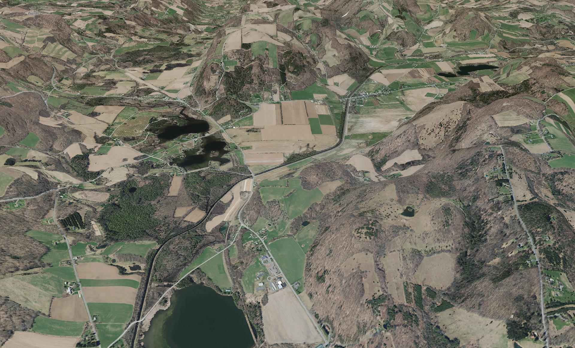
This shows a 3D rendering of the Buckville Canal north of Hamilton
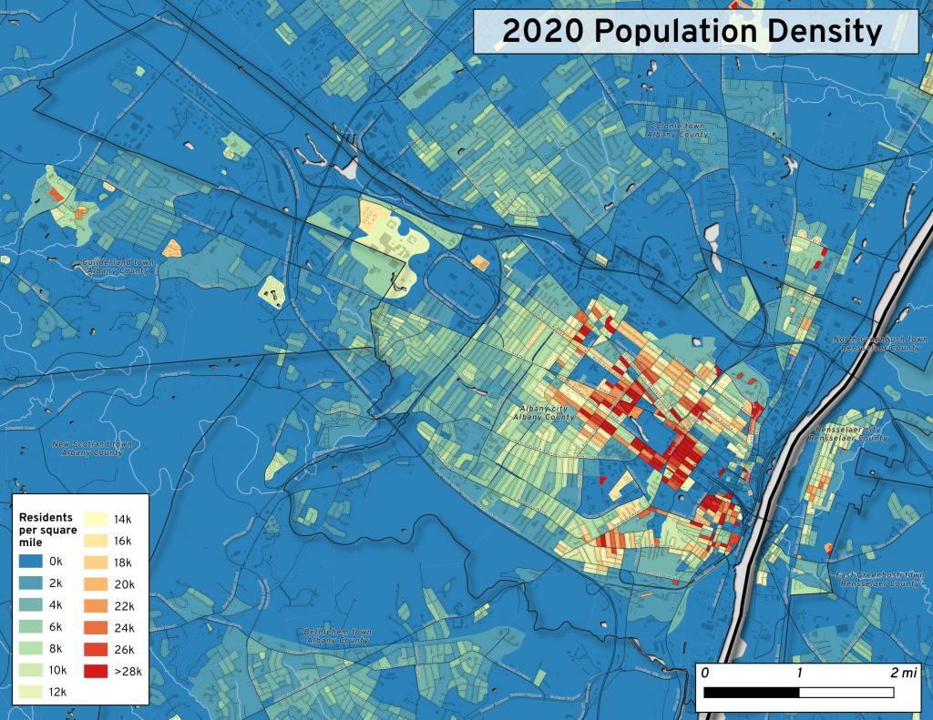
This map shows the use of 2020 PL 94-171 data to calculate population density in City of Albany.
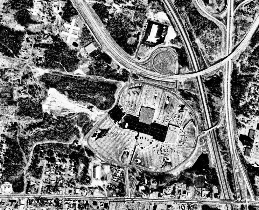
This 1985 aerial photo shows Crossgates Mall prior to it’s expansion.

This GIF image shows the change in unemployment during Coronavirus panademic.
This image shows hiking trails near Brooktrout, Falls Pond and Deep Lake.
Peebles Island, a Comparison 1952
3D Interactive of campsites at Moose River Plains.

Sample tax map in Albany.

Election results – 2020 Presidential Election, Onondoga County.

Map showing where sparklers are legally sold in New York.
Downtown Plattsburgh 1866 Beers (1866 Beers vs. 2020 OSM)
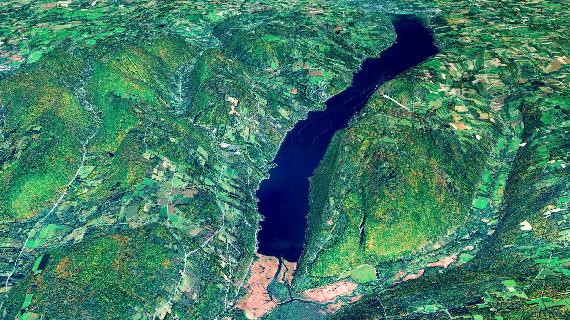
3D Rendering of Canandaigua Lake
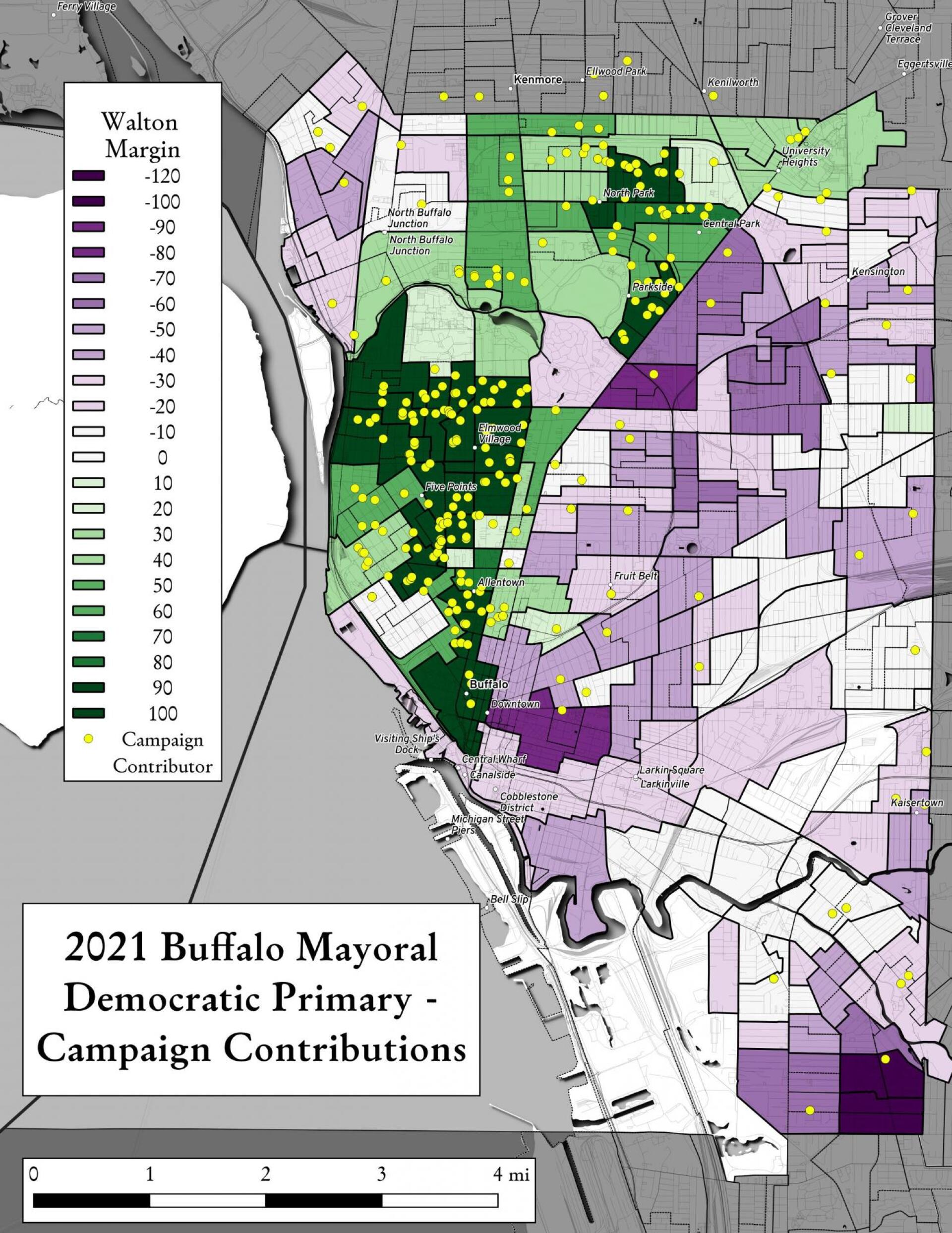
Map showing Buffalo Mayoral Primary results and campaign donors.
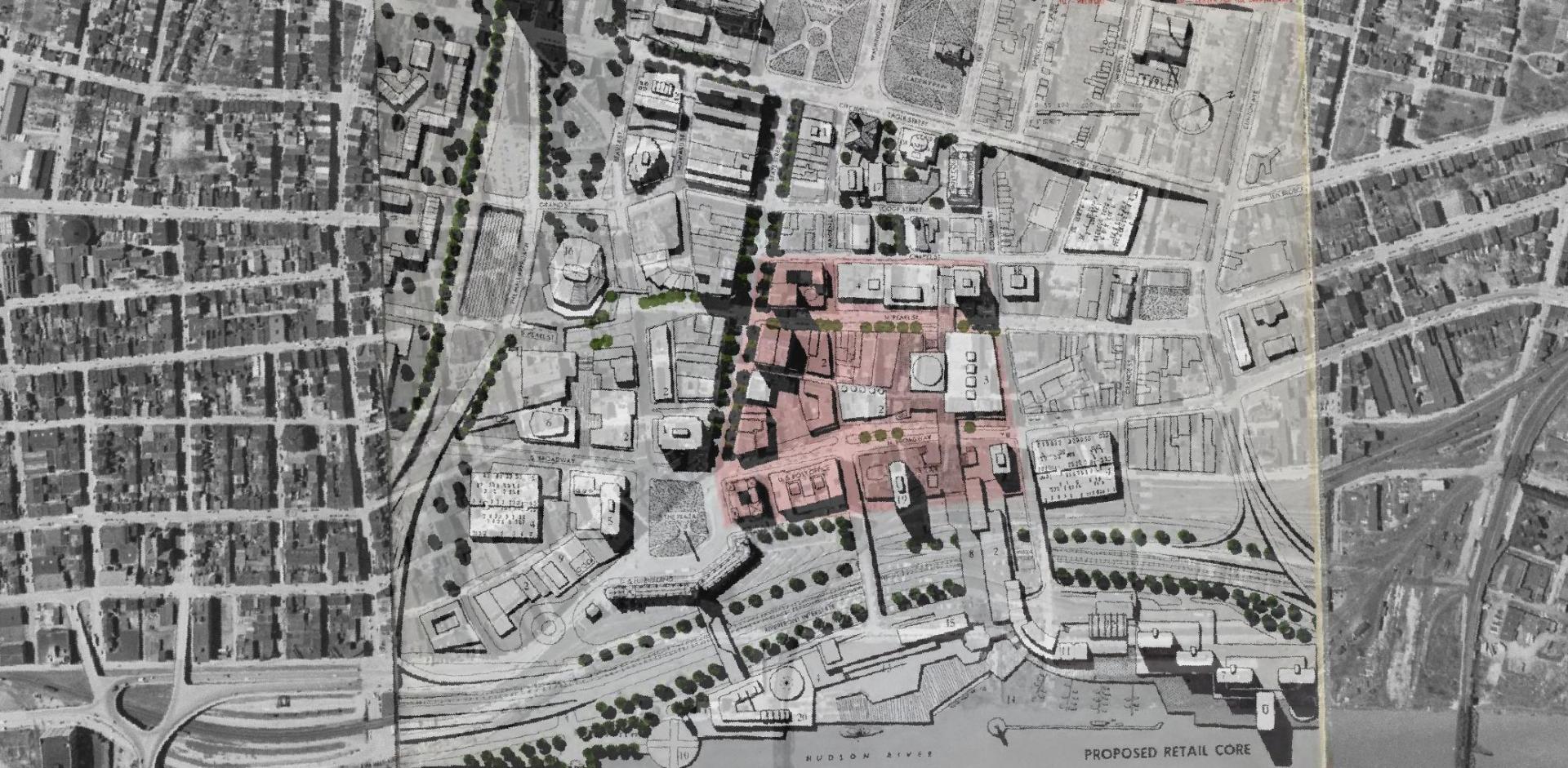
Overlay of Proposed Retail Core in 1963 Plan for the Capital City.

Map showing Local Area Unemployment Statistics – April 2020.
Interactive tax map in Delmar
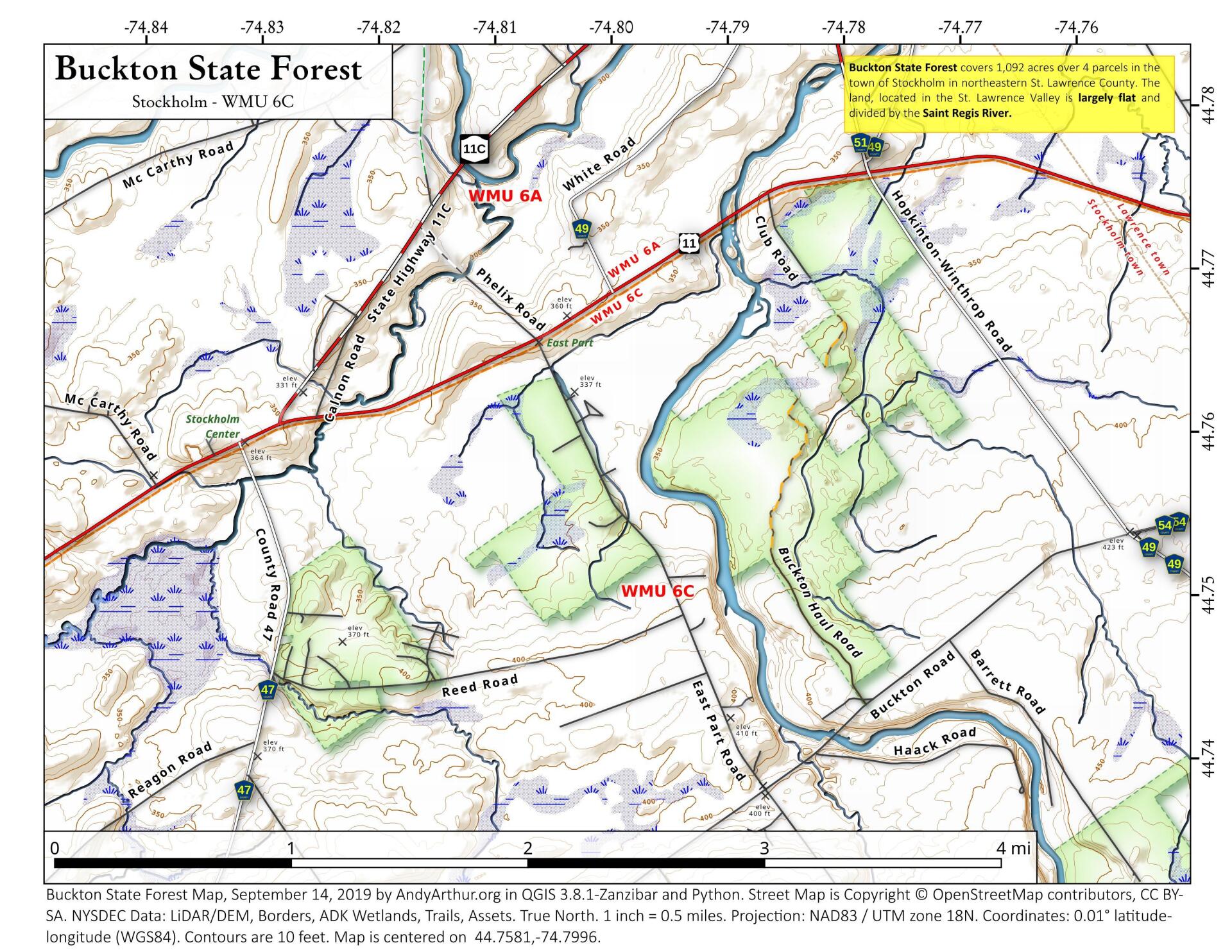
State Land in Stockholm, NY – Buckton State Forest.
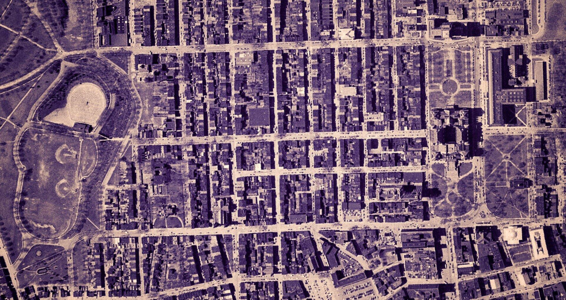
Empire State Plaza take area, 1952
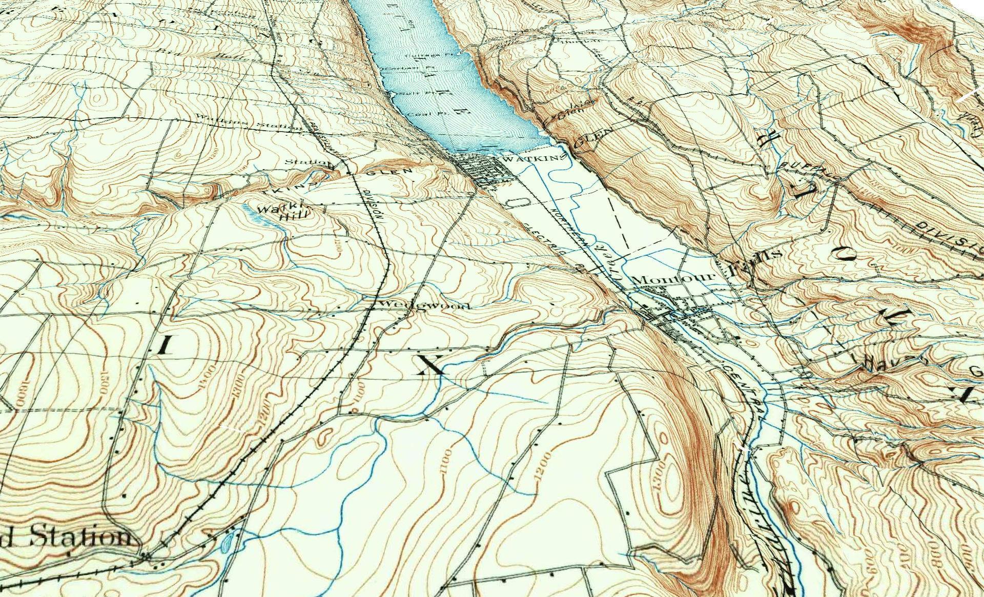
3D Rendering of the 1898 Watkins Glen Topographic Map
Properties in Albany Pine Bush Study Area,Excel Files: Various Tax Rolls,Find coordinates and political districts,Look Up State Tax Records and aScript for Processing RPTL 1520 PDFs.
Querying state property database, political enrollments, PL 94-171 Census files, calculating population statistics, what address is a district in, converting old districts to new districts.
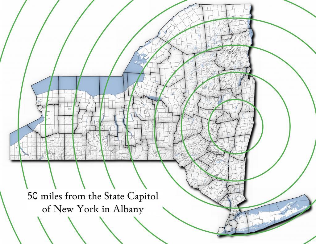
| Miles from Albany | millions population |
| 50 | 1.002 |
| 100 | 1.750 |
| 150 | 3.511 |
| 200 | 17.102 |
| 250 | 17.725 |
| 300 | 18.699 |
| 350 | 19.411 |
| 400 | 20.187 |
| 450 | 20.201 |
import pandas as pd
import geopandas as gpd

# path to overlay shapefile
overlayshp = r'/tmp/dis_to_albany.gpkg'

# summary level -- 750 is tabulation block, 150 is blockgroup
# large areas over about 50 miles much faster to use bg
summaryLevel = 150
#summaryLevel = 750

# path to block or blockgroup file
if summaryLevel == 150:
    blockshp = r'/home/andy/Documents/GIS.Data/census.tiger/36_New_York/tl_2020_36_bg20.shp.gpkg'
else:
    blockshp = r'/home/andy/Documents/GIS.Data/census.tiger/36_New_York/tl_2020_36_tabblock20.shp.gpkg'

# path to PL 94-171 redistricting geoheader file
pl94171File = '/home/andy/Desktop/nygeo2020.pl'

# field to categorize on (such as Ward -- required!)
catField = 'Name'

# geo header contains 2020 census population in column 90
# per PL 94-171 documentation, low memory chunking disabled
# as it causes issues with the geoid column being mixed types
df=pd.read_csv(pl94171File,delimiter='|',header=None, low_memory=False )

# column 2 is summary level
population=df[(df.iloc[:,2] == summaryLevel)][[9,90]]

# load overlay
overlay = gpd.read_file(overlayshp).to_crs(epsg='3857')

# shapefile of nys 2020 blocks, IMPORTANT (!) mask by output file for speed
blocks = gpd.read_file(blockshp,mask=overlay).to_crs(epsg='3857')

# geoid for linking to shapefile is column 9
joinedBlocks=blocks.set_index('GEOID20').join(population.set_index(9))

# store the size of unbroken blocks
# in case overlay lines break blocks into two
joinedBlocks['area']=joinedBlocks.area

# run union
unionBlocks=gpd.overlay(overlay, joinedBlocks, how='union')

# drop blocks outside of overlay
unionBlocks=unionBlocks.dropna(subset=[catField])

# create population projection when a block crosses
# an overlay line -- avoid double counting -- this isn't perfect
# as we loose a 0.15 percent due to floating point errors
unionBlocks['sublock']=unionBlocks[90]*(unionBlocks.area/unionBlocks['area'])

# sum blocks in category
unionBlocks=pd.DataFrame(unionBlocks.groupby(catField).sum()['sublock'])

# rename columns
unionBlocks=unionBlocks.rename({'sublock': '2020 Census Population'},axis=1)

# calculate cumulative sum as you go out each ring
unionBlocks['millions']=unionBlocks.cumsum(axis=0)['2020 Census Population']/1000000

# each ring is 50 miles
unionBlocks['miles']=unionBlocks.index*50

# output
unionBlocks
Most highly assessed properties in Albany County …
from arcgis.features import FeatureLayer
lyr_url = 'https://gisservices.its.ny.gov/arcgis/rest/services/NYS_Tax_Parcel_Centroid_Points/MapServer/0'
layer = FeatureLayer(lyr_url)
query_result1 = layer.query(where="COUNTY_NAME='Albany' AND FULL_MARKET_VAL > 100000000",
                                    out_fields='PARCEL_ADDR,CITYTOWN_NAME,FULL_MARKET_VAL,OWNER_TYPE', out_sr='4326')

df=query_result1.sdf.sort_values(by='FULL_MARKET_VAL', ascending=False)
df['Full Market Value'] = df['FULL_MARKET_VAL'].map('${:,.0f}'.format)

df
| OBJECTID | PARCEL_ADDR | CITYTOWN_NAME | FULL_MARKET_VAL | OWNER_TYPE | SHAPE | Full Market Value | |
|---|---|---|---|---|---|---|---|
| 11 | 26652 | 64 Eagle St | Albany | 1204254925 | 2 | {“x”: -73.75980312511581, “y”: 42.650469918250… | $1,204,254,925 |
| 3 | 9150 | 1200 Washington Ave | Albany | 886298715 | 2 | {“x”: -73.81092293494828, “y”: 42.679257168282… | $886,298,715 |
| 4 | 10208 | 1400 Washington Ave | Albany | 642398287 | 2 | {“x”: -73.82369286130952, “y”: 42.685845700657… | $642,398,287 |
| 0 | 885 | 251 Fuller Rd | Albany | 440042827 | 2 | {“x”: -73.83559002316825, “y”: 42.690208093507… | $440,042,827 |
| 5 | 18164 | 632 New Scotland Ave | Albany | 377568201 | 8 | {“x”: -73.80381341626146, “y”: 42.655758957669… | $377,568,201 |
| 1 | 906 | 141 Fuller Rd | Albany | 321199143 | 2 | {“x”: -73.83323986150171, “y”: 42.693189748928… | $321,199,143 |
| 19 | 108087 | See Card 1067 | Watervliet | 280898876 | 1 | {“x”: -73.70670724174552, “y”: 42.719628647232… | $280,898,876 |
| 15 | 65380 | 737 Alb Shaker Rd | Colonie | 263916100 | 3 | {“x”: -73.80365248218001, “y”: 42.747956678125… | $263,916,100 |
| 9 | 21923 | 304 Madison Ave | Albany | 234265418 | 2 | {“x”: -73.76227373289564, “y”: 42.648000674457… | $234,265,418 |
| 2 | 907 | 201 Fuller Rd | Albany | 203426124 | 2 | {“x”: -73.83362605353057, “y”: 42.692609131686… | $203,426,124 |
| 16 | 69999 | 515 Loudon Rd | Colonie | 166065600 | 8 | {“x”: -73.74958475282632, “y”: 42.719321807666… | $166,065,600 |
| 7 | 20592 | 47 New Scotland Ave | Albany | 162276338 | 8 | {“x”: -73.77597163421673, “y”: 42.653565689693… | $162,276,338 |
| 6 | 20574 | 132 S Lake Ave | Albany | 146296360 | 2 | {“x”: -73.77970918544908, “y”: 42.654390366929… | $146,296,360 |
| 8 | 20597 | 113 Holland Ave | Albany | 143498501 | 2 | {“x”: -73.77306688593143, “y”: 42.650762742870… | $143,498,501 |
| 17 | 78203 | Mannsville | Colonie | 142570400 | 1 | {“x”: -73.71245452369443, “y”: 42.718124477080… | $142,570,400 |
| 18 | 95509 | 1 Crossgates Mall Rd | Guilderland | 130554700 | 8 | {“x”: -73.84702700595471, “y”: 42.687699053797… | $130,554,700 |
| 10 | 24521 | 86 S Swan St | Albany | 128436403 | 2 | {“x”: -73.75980563770365, “y”: 42.653931892804… | $128,436,403 |
| 13 | 46883 | 1916 US 9W | Coeymans | 110000000 | 8 | {“x”: -73.83388475575597, “y”: 42.488730743021… | $110,000,000 |
| 12 | 35152 | 380 River Rd | Bethlehem | 105263158 | 8 | {“x”: -73.76445503554325, “y”: 42.595925419330… | $105,263,158 |
| 14 | 65097 | 15 Wolf Rd | Colonie | 101967213 | 8 | {“x”: -73.81423716588279, “y”: 42.709939498581… | $101,967,213 |
Good evening! Mostly clear and 44 degrees in Delmar, NY. There is a south breeze at 5 mph. 🍃. Temperatures will drop below freezing at Thursday around 3 am. ☃️
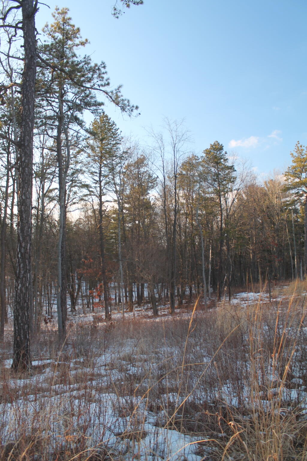
Mild evening 🌃, enjoyed my evening walk. 🚶 I ended up walking quite a few miles today, visiting a number of preserves and it was a nice day. Always try to spend a lot of time looking at the trees, observing birds 🐦 and wildlife, trying to go through life not too blind to the world around me. Spent a lot of time in the woods this weekend for sure. Even if I don’t travel far there is a lot of nature locally.
Driving 🚘 back through Berne got me thinking how much the hill towns are not unlike small rural towns everywhere. 🐮 Looking at Sauk County Wisconsin over the past week on the YouTube, and thinking back to my trips to West Virginia and Pennsylvania got me thinking how many nice small towns outside of New York I could ultimately settle down in and have a lot more freedom 🆓 than in New York State. Maybe the pasture isn’t greener everywhere but I see the plastic bag ban and these massive but low output solar farms as a sign of what’s to come and it’s not good. The same with the wilderness activists and anti frackers locking 🔒 all our land. To say nothing of more and more suburban track housing and apartment complexes going up everywhere. I miss the small town life I grew up in but I can’t see buying property in New York at this point. Once I don’t have family in New York, I’m towing everything I can out of the state for greener pastures.
Tonight will be partly cloudy 🌤, with a low of 34 degrees at 5am. 11 degrees above normal, which is similar to a typical night around April 6th. Going to be cool at night but it’s only the second week of March. At least my heat is off. ♨ South wind 5 to 7 mph. In 2019, we had clear skies in the evening, which became clear by the early hours of the morning. It got down to 12 degrees. The record low of -14 occurred back in 1943.
Tonight will have the Worm Full 🀼/strong>Moon. At 10 PM, the moon was in the east-southeast (119°) at an altitude of 44° from the horizon, some 227,258 miles away from where you are looking up from the earth. 🚀It’s a pretty big moon with a lot of moonlight. Didn’t need the brights on much driving home from the parents house. At the state speed limit of 55 mph, you’ll make it there by August 28th. Buckle up for safety! 💺 The darkest hour is at 12:07 am, followed by dawn at 6:51 am, and sun starting to rise at 7:20 am in the east (96°) and last for 2 minutes and 54 seconds. Sunrise is one minute and 42 seconds earlier than today. 🌄 Still dark morning ahead. The golden hour ends at 7:57 am with sun in the east-southeast (102°). Tonight will have 12 hours and 22 minutes of darkness, a decrease of 2 minutes and 54 seconds over last night.
Tomorrow will be sunny 🌞, with a high of 68 degrees at 4pm. 27 degrees above normal, which is similar to a typical day around May 10th. Outstanding. South wind 6 to 9 mph. But red flag 🚩 conditions so tomorrow is a day you shouldn’t be burning stuff you shouldn’t be 🔥 but my neighbors was having a nice fire out back. A year ago, we had cloudy skies in the morning with more sun in the afternoon. The high last year was 42 degrees. The record high of 81 was set in 2016. 6.9 inches of snow fell back in 1961.❄
In four weeks on April 5 the sun will be setting in the west (279°) at 7:26 pm,🌄 which is 32 minutes and 25 seconds later then tonight. In 2019 on that day, we had partly cloudy skies, rain showers and chilly temperatures between 42 and 25 degrees. Typically, you have temperatures between 54 and 33 degrees. Yes, you can still have winter in April. The record high of 82 degrees was set back in 1928.
Looking ahead, Ides of March ✝ is in 1 week, Pink Moon 🌕 is a month away, Palm Sunday 🌴 is in 4 weeks, Easter 🐰 is in 5 weeks, Mothers Day 👩 is in 9 weeks, Pack Rat Day 🐀 is in 10 weeks, Strawberry Moon 🌕 is in 13 weeks and Fathers Day 👨 is in 14 weeks.
🇺🇸🦅Only 74 days remain until the start of Memorial Day Weekend!🦅🇺🇸
Good evening on this final blog post of 2019 ! Cloudy and 31 degrees at the Cole Hill State Forest in Berne on this New Years Eve. ☁ We had a thunderstorm with some brief lightning and snow. ⚡ ❄ It was windy and intense for about five minutes and then it got quiet. There is a west-southwest breeze at 9 mph. 🍃. There is about 4 inches of snow on the ground. ☃ The skies will clear tomorrow around noontime.
It’s hard to believe that New Years Day is only a few hours away and it will be 2020. 🎇 To think it’s already the twenties when not all that long ago it was year 2000 and I was back in High School. I’ll be waking tomorrow to a brand new decade. Although it’s already basically 11 o’clock now and I could if I wanted to stay up the next hour listening to a podcast until midnight. I was outside by the fire until 10:30 when a snow squall and the breeze made me decide to jettison the cold ❄ outside for a nice warm tent 🎪. Maybe I will stay up to midnight 🕛, I’m in no rush to take down camp as things with the dropping temperatures are likely to be frozen early in the day until the sun comes out. Simple breakfast of instant oatmeal 🍚 and coffee ☕ for breakfast tomorrow and then it’s just a 20 minute drive home.
Tonight will have a chance of snow showers, mainly before 10pm. Mostly cloudy 🌧, with a low of 25 degrees at 6am. Nine degrees above normal, which is similar to a typical night around December 7th. Even warmer back in the city. West wind 9 to 15 mph, with gusts as high as 25 mph. A few good gusts earlier for sure with that winter thunderstorm. The wind is a bit concerning with the ice on the trees being thrown or broken limbs but my campsite is relatively free of widow makers. 🍃 Chance of precipitation is 50%. Total nighttime snow accumulation of less than a half inch possible. In 2018, we had light rain in the evening, which became cloudy by the early hours of the morning. It got down to 27 degrees. I was up at Cherry Ridge last year and I left the night before because I was worried 😯 about the road being slippery when the ice turned to mud. In retrospect, should have done Moscow Hill horse 🐴 camp instead. The record low of -18 occurred back in 1970.
Tonight will have a Waxing Crescent 🌒 Moon with 31% illuminated. At dusk you’ll see the moon in the south (190°) at an altitude of 37° from the horizon, some 251,948 miles away from where you are looking up from the earth. 🚀It was kind of a pretty moon tonight and it seems like my astrological calculations are right. The moon will set in the west-southwest (257°) at 10:06 pm. The darkest hour is at 12:00 am (the beginning of the decade), followed by dawn at 6:55 am, and sun starting to rise at 7:27 am in the east-southeast (121°) and last for 3 minutes and 25 seconds. Sunrise is 9 seconds later than yesterday. 🌄 The golden hour ends at 8:13 am with sun in the southeast (129°) at an altitude of 6°. Tonight will have 14 hours and 53 minutes of darkness, a decrease of 42 seconds over last night.
New Year’s Day 🎇 will have isolated snow showers after 8am. Partly sunny 🌦, with a high of 34 degrees at 1pm. Three degrees above normal, which is similar to a typical day around December 22nd. West wind 15 to 17 mph, with gusts as high as 31 mph. Chance of precipitation is 20%. A year ago, we had mostly sunny skies in the morning, which became light drizzle by afternoon. The high last year was 53 degrees. The record high of 57 was set in 1966. 9.2 inches of snow fell back in 1961.❄
This year my New Year Resolution is to stay the course 🚢and continue to build a better life for myself. I want to keep saving money towards buying land and an off grid cabin. I might stay in New York for another decade but when the time comes, I want to be prepared. I’ll have to see if Big Red needs repairs and decide on my future of motoring 🏁 or if I should try a life with more biking and local adventures. Sure these winter camping adventures are kind of fun but motoring is so expensive and bad for both the environment and ones health. I probably also drink and eat too much unhealthy food while camping although this time ⌚ I intentionally limited my drinking by packing less beer 🍻 being that I’m out in the real wilderness in the cold. That and I drunk most of it earlier in the week. ⛺ That said, this coming year I plan to spend many nights in the woods and maybe even so a bit more wilderness camping.
In four weeks on January 28 the sun will be setting in the west-southwest (246°) at 5:04 pm,🌄 which is 31 minutes and 28 seconds later then tonight. In 2019 on that day, we had sunny weather and but rather cold temperatures between 22 and 8 degrees. Typically, you have temperatures between 31 and 15 degrees. The record high of 56 degrees was set back in 1916.
Looking ahead, Coldest Week of the Year 🌬 is in 2 weeks, Martin Luther King Day 🖤 is in 3 weeks, Don’t Cry over Spilled Milk Day 🥛 is in 6 weeks, National Drink Wine Day 🍷 is in 7 weeks, St. Patrick’s Day 🍀 is in 11 weeks, 7:30 PM Sunset 🌇 is in 14 weeks, Cinco de Mayo 🤠 is in 18 weeks, Primary Day 🗳️ is in 25 weeks, Election Day 2020 🗳️ is in 44 weeks and Election Day 2020 🗳️ is in 44 weeks.
Good morning! Monday’s come back around again. Next Monday is Presidents Day 👴. Light snow and 25 degrees in Delmar. ❄ Kind of a pretty snow, really only impacting parking lots and side roads so far. Big snow tomorrow, again. There is a north-northwest breeze at 5 mph. 🍃. Things will start to thaw out at around 1 pm. 🌡️
Back to work today, taking the local bus downtown. 🚌 Going to be another really busy day at work but I’m getting used to the new routine. I think it makes the days go by faster. At least it’s only a two day session week, although I did pack dinner for tonight. Tomorrow shouldn’t be too long I’m thinking as members are going to want to leave town early with the snow and the President’s Week holiday. ❄
Feeling well rested after the sleeping pill I took last night. 😴 I hate sleeping this time of year although once the time changes and I can leave the windows open at night it should get easier. It also helps that the automatic dimming of the lights got me to bed at a reasonable hour.
Today will have a chance of light snow, mainly before 10am. Mostly cloudy 🌨, with a high of 33 degrees at 2pm. One degrees below normal, which is similiar to a typical day around February 10th. North wind 5 to 7 mph. Chance of precipitation is 30%. Total daytime snow accumulation of less than a half inch possible. A year ago, we had light freezing rain. The high last year was 37 degrees. The record high of 59 was set in 1981. 9.6 inches of snow fell back in 1933.❄
The sun will set at 5:22 pm with dusk around 5:51 pm, which is one minute and 18 seconds later than yesterday. 🌇 At sunset, look for partly cloudy skies 🌃 and temperatures around 28 degrees. There will be a north breeze at 7 mph. Today will have 10 hours and 25 minutes of daytime, an increase of 2 minutes and 37 seconds over yesterday.
Tonight will be mostly cloudy 🌥, with a low of 8 degrees at 6am. Nine degrees below normal. Maximum wind chill around -1 at 5am; North wind around 7 mph. In 2018, we had mist in the evening, which became cloudy by the early hours of the morning. It got down to 22 degrees. The record low of -16 occurred back in 1979.
Tomorrow will snow, mainly after 11am. The snow could be heavy at times. 🌨 High of 27 degrees at 6pm. Six degrees below normal. Northeast wind 6 to 9 mph becoming east in the afternoon. Chance of precipitation is 100%. New snow accumulation of 3 to 5 inches possible. A year ago, we had light freezing rain. The high last year was 38 degrees. The record high of 55 was set in 1932. 13.5 inches of snow fell back in 1988.❄
While usually I like snow, I’m hardly thrilled about having to dig Big Red out again after the snow. 🚗At least living in the city, I won’t have to drive in it and I can wear my snow boots. Probably will turn the heat up tonight just on case we lose power and because it’s going to be a cold night and I don’t want things to fall too far behind on the heating front, less the hot water pipe freeze and my shower is cold come morning. 🚿 I’m parked in my winter spot and hopefully the landlord will have my normal spot well cleaned after the storm and I can move my truck back there come the weekend.
It was a nice walk up at Partridge Run WMA yesterday afternoon. Not too bad but very icy. Some areas up there were a sheet of ice with the snow melt off the hills sides. I am very glad I wore my micro spikes. 🌲Walked along the Switz Kill then across the gravel pit up to the Gulf. Walked across a frozen lake, I thought I heard a crack as I crossed it.😮 But I guess it was just the ice shifting. It seemed like it was pretty solid. Then I saw a snowy owl fly overhead.🕊 I wanted to get a picture but it was gone too quickly. The lower Partridge Run Road Bridge is really falling apart with even more of the deck rotting away.🏞 I wonder if they will eventually replace it with a pedestrian bridge? Likewise more and more of the road is disappearing – Irene took away a lot of the road, but now its just eroding quicker that the rip rap is gone.
I enjoyed seeing the open country, I miss living in the country. I’ve always liked the Switz Kill Valley and the rural lands around Berne 🐄although I can’t imagine owning land in New York with all the taxes and regulations. 👿
Had a nice dinner at my parents house. They made up meatball riggis. Did my wash came home. It was nice seeing the folks. 👪
For lunch at work, I finally bought some real metal forks, as I got tired of breaking the plastic forks I usually use. 🍴 They were so inexpensive at under a buck for the most basic model, and I figure they will last longer — although most of the plastic forks I’ve used over the years I’ve gotten for free.
Finished working on the lights in my bedroom, although now I have to write the phone app, although I already have an earlier version I can use that I built that I can use as a template. 📃At this point I’m just building non essential features, most of which are simple to implement now that the framework is done. 💡
Last week I bought a IOT enclosed relay. Not a big purchase, it’s basically a surge protector and a relay integrated into one, as an alternative to building my own switched relay for driving one of the 120 volt lamps in my bedroom. 🔌 High voltage scares me a bit, especially the possibility that leads could accidentally get pulled loose on the floor, leading to a fire or deadly current.
I just want a little more light and those commercial LED bulbs are very efficient and have much better color rendition than my LED strip but I want to be able to control them from my micro controller and phone, and make part of the lights when I wake in the morning. 💡 While I’m sure I could build my own by the time I bought the outlet, the relay, junction box and cover plate I figured it was cheaper to buy the $20 pre-assembled unit especially when I want to switch only one outlet to drive a single bulb. I could see buying one of those gang relays and wiring up the plug if I had a lot of lights I wanted to switch, and a way to tie up the cords, but I feel safer getting a UL certified device anytime I’m working with mains voltage, especially if it’s going to be plugged in all the time by my bed.
Fan started working again on my laptop. ⚠ No more error at boot, but still very noisy. I think it’s only one of the fan units that is causing the problem. I will have to get some canned air and see if I can clean the fan out the next time I’m at the store. I keep forgetting to buy the canned air so I can do it, although I was quite happy with only one of the internal fans working, it made things a lot more quiet.
Right now, a split verdict on the weekend. 🤔 Saturday, a chance of rain. Mostly cloudy, with a high near 44. Chance of precipitation is 50%. Sunday, partly sunny, with a high near 30. Typical average high for the weekend is 35 degrees.
Next Monday is Presidents Day 👴 when the sun will be setting at 5:31 pm with dusk at 6:00 pm. It will be partly cloudy with a chance of snow showers, and a high of 38 degrees. On that day in 2018, we had partly sunny, snow showers and temperatures between 40 and 23 degrees. Typically, the high temperature is 35 degrees. We hit a record high of 63 back in 1981.
In four weeks on March 11 the sun will be setting at 6:57 pm (Daylight Savings Time),🌄 which is one hour, 34 minutes and 54 seconds later then today. In 2018 on that day, we had partly cloudy and temperatures between 36 and 28 degrees. Typically, you have temperatures between 42 and 24 degrees. The record high of 70 degrees was set back in 1977.
Not sure if I will head out of town but I very well may go camping locally on Sunday night. ⛺ Probably hot tent locally as there is still much to much snow in the Adirondacks to camp especially with the limited parking along NY 8 this time of year. Plus like usual my budget is tight and I’d rather save my miles and gasoline for the summer when it’s really nice. ⛽ Hiding out at the Potholers during the brutal heat of last summer was a lot of fun last year.
Looking ahead, Presidents Day 👴 is in 1 weeks, Average High is 40 ☀️ is in 3 weeks, April Fools Day 🤡 is in 7 weeks, Tax Day 💰 is in 9 weeks, Earth Day 🌎 is in 10 weeks, Memorial Day 🇺🇸 is in 15 weeks, July 🏊🏿 is in 20 weeks and Last Sunset After 8 PM 🌆 is in 26 weeks.
About a year ago, in the Capital Region Solid Waste Plan, the City of Albany proposed creating a mega-solid waste authority to manage the Solid Waste for most of the Eastern Half of New York State. The plan specifically called for creating a regional authority — to service up to nine counties, and cover an area of 100 miles from the center point of the Rapp Road Landfill.
So I decided to make a map, and run some numbers…
100 square miles equals roughly 30,500 square miles, with 21,500 sq miles in New York State and 9,000 sq miles out of State — primarily Southern Vermont, but also most of Western Massachussets, roughly 3/4th of Connecicut, and part of Pennsylvania in the Poconos.
In contrast to 30,500 square miles, Adirondack Park “Blue Line” covers roughly 9,100 sq miles in NY State and the Catskill Park “Blue Line” covers roughly 1,100 sq miles. That includes all land within those parks, publicly and privately owned.
That area, within NY State, covers an area were 2,957,993 persons reported residing in the 2010 census.
That is 2.95 million people, or almost 3 million people, a population greater then Manhattan at 1.5 million persons, and even Brooklyn at 2.5 million.
While no one town or city in the proposed in Authorty is particularly large — the City of Albany is the largest population center at 97,856 followed by Colonie at 81,591, the reality is those numbers add up, when you include the 406 towns and cities in NY State that fall within the 100 mile distance from the Rapp Road Landfill.
| Town /City | Population |
|---|---|
| Albany city | 97,856 |
| Colonie town | 81,591 |
| Schenectady city | 66,135 |
| Utica city | 62,235 |
| Troy city | 50,129 |
| Poughkeepsie town | 43,341 |
| Cortlandt town | 41,592 |
| Monroe town | 39,912 |
| Clifton Park town | 36,705 |
| Yorktown town | 36,081 |
| Guilderland town | 35,303 |
| Carmel town | 34,305 |
| Rome city | 33,725 |
| Bethlehem town | 33,656 |
| Poughkeepsie city | 32,736 |
| Warwick town | 32,065 |
| Newburgh town | 29,801 |
| Glenville town | 29,480 |
| Rotterdam town | 29,094 |
Here is entire list of towns partially or wholely contained in the proposed jurisdiction of the Albany Solid Waste Authority (including large cities and towns listed above)…
| Town /City | Population | Area (sq mi) | Pop sq/mi |
|---|---|---|---|
| Albany city | 97,856 | 21 | 4659.8 |
| Colonie town | 81,591 | 57 | 1431.4 |
| Schenectady city | 66,135 | 10 | 6613.5 |
| Utica city | 62,235 | 16 | 3889.7 |
| Troy city | 50,129 | 11 | 4557.2 |
| Poughkeepsie town | 43,341 | 31 | 1398.1 |
| Cortlandt town | 41,592 | 49 | 848.8 |
| Monroe town | 39,912 | 21 | 1900.6 |
| Clifton Park town | 36,705 | 50 | 734.1 |
| Yorktown town | 36,081 | 39 | 925.2 |
| Guilderland town | 35,303 | 58 | 608.7 |
| Carmel town | 34,305 | 40 | 857.6 |
| Rome city | 33,725 | 75 | 449.7 |
| Bethlehem town | 33,656 | 50 | 673.1 |
| Poughkeepsie city | 32,736 | 5 | 6547.2 |
| Warwick town | 32,065 | 105 | 305.4 |
| Newburgh town | 29,801 | 46 | 647.8 |
| Glenville town | 29,480 | 50 | 589.6 |
| Rotterdam town | 29,094 | 36 | 808.2 |
| East Fishkill town | 29,029 | 57 | 509.3 |
| Newburgh city | 28,866 | 4 | 7216.5 |
| Middletown city | 28,086 | 5 | 5617.2 |
| Queensbury town | 27,901 | 64 | 436.0 |
| Wallkill town | 27,426 | 62 | 442.4 |
| Wappinger town | 27,048 | 28 | 966.0 |
| Saratoga Springs city | 26,586 | 28 | 949.5 |
| New Windsor town | 25,244 | 36 | 701.2 |
| Kingston city | 23,893 | 8 | 2986.6 |
| Peekskill city | 23,583 | 5 | 4716.6 |
| Montgomery town | 22,606 | 51 | 443.3 |
| New Hartford town | 22,166 | 25 | 886.6 |
| Fishkill town | 22,107 | 32 | 690.8 |
| Niskayuna town | 21,781 | 15 | 1452.1 |
| Hyde Park town | 21,571 | 39 | 553.1 |
| Halfmoon town | 21,535 | 33 | 652.6 |
| Somers town | 20,434 | 32 | 638.6 |
| Saugerties town | 19,482 | 67 | 290.8 |
| Whitestown town | 18,667 | 27 | 691.4 |
| Amsterdam city | 18,620 | 6 | 3103.3 |
| Milton town | 18,575 | 35 | 530.7 |
| Southeast town | 18,404 | 34 | 541.3 |
| Blooming Grove town | 18,028 | 35 | 515.1 |
| East Greenbush town | 16,473 | 24 | 686.4 |
| Wilton town | 16,173 | 35 | 462.1 |
| Cohoes city | 16,168 | 4 | 4042.0 |
| La Grange town | 15,730 | 40 | 393.3 |
| Gloversville city | 15,665 | 5 | 3133.0 |
| Beacon city | 15,541 | 4 | 3885.3 |
| Thompson town | 15,308 | 87 | 176.0 |
| Stony Point town | 15,059 | 31 | 485.8 |
| Malta town | 14,765 | 31 | 476.3 |
| Moreau town | 14,728 | 43 | 342.5 |
| Glens Falls city | 14,700 | 3 | 4900.0 |
| Beekman town | 14,621 | 30 | 487.4 |
| Shawangunk town | 14,332 | 56 | 255.9 |
| New Paltz town | 14,003 | 34 | 411.9 |
| Oneonta city | 13,901 | 4 | 3475.3 |
| Goshen town | 13,687 | 44 | 311.1 |
| Kent town | 13,507 | 43 | 314.1 |
| German Flatts town | 13,258 | 34 | 389.9 |
| Wawarsing town | 13,157 | 133 | 98.9 |
| Fallsburg town | 12,870 | 79 | 162.9 |
| Schodack town | 12,794 | 63 | 203.1 |
| Kingsbury town | 12,671 | 40 | 316.8 |
| Cornwall town | 12,646 | 28 | 451.6 |
| Highlands town | 12,492 | 33 | 378.5 |
| Lewisboro town | 12,411 | 29 | 428.0 |
| Ulster town | 12,327 | 28 | 440.3 |
| Mamakating town | 12,085 | 98 | 123.3 |
| North Greenbush town | 12,075 | 18 | 670.8 |
| Patterson town | 12,023 | 32 | 375.7 |
| Chester town | 11,981 | 87 | 137.7 |
| Chester town | 11,981 | 25 | 479.2 |
| Brunswick town | 11,941 | 44 | 271.4 |
| Putnam Valley town | 11,809 | 42 | 281.2 |
| Catskill town | 11,775 | 64 | 184.0 |
| Oneida city | 11,393 | 22 | 517.9 |
| Woodbury town | 11,353 | 37 | 306.8 |
| Red Hook town | 11,319 | 40 | 283.0 |
| Lloyd town | 10,863 | 33 | 329.2 |
| Plattekill town | 10,499 | 35 | 300.0 |
| Kirkland town | 10,315 | 33 | 312.6 |
| Watervliet city | 10,254 | 1 | 10254.0 |
| Herkimer town | 10,175 | 32 | 318.0 |
| Liberty town | 9,885 | 80 | 123.6 |
| Ballston town | 9,776 | 30 | 325.9 |
| Pleasant Valley town | 9,672 | 33 | 293.1 |
| Philipstown town | 9,662 | 51 | 189.5 |
| Rensselaer city | 9,392 | 3 | 3130.7 |
| Crawford town | 9,316 | 40 | 232.9 |
| Lenox town | 9,122 | 36 | 253.4 |
| Esopus town | 9,041 | 41 | 220.5 |
| Marcy town | 8,982 | 33 | 272.2 |
| North Elba town | 8,957 | 156 | 57.4 |
| Coxsackie town | 8,918 | 38 | 234.7 |
| Marlborough town | 8,808 | 26 | 338.8 |
| Johnstown city | 8,743 | 4 | 2185.8 |
| Dover town | 8,699 | 56 | 155.3 |
| New Scotland town | 8,648 | 57 | 151.7 |
| Sand Lake town | 8,530 | 36 | 236.9 |
| Kinderhook town | 8,498 | 32 | 265.6 |
| Pawling town | 8,463 | 45 | 188.1 |
| Waterford town | 8,423 | 7 | 1203.3 |
| Stillwater town | 8,287 | 43 | 192.7 |
| Deerpark town | 7,901 | 67 | 117.9 |
| Greenfield town | 7,775 | 67 | 116.0 |
| Schaghticoke town | 7,679 | 51 | 150.6 |
| Frankfort town | 7,636 | 36 | 212.1 |
| Rhinebeck town | 7,548 | 39 | 193.5 |
| Coeymans town | 7,418 | 53 | 140.0 |
| Rochester town | 7,313 | 89 | 82.2 |
| Wawayanda town | 7,266 | 35 | 207.6 |
| Norwich city | 7,190 | 2 | 3595.0 |
| Johnstown town | 7,098 | 71 | 100.0 |
| Mount Hope town | 7,018 | 25 | 280.7 |
| Hoosick town | 6,924 | 63 | 109.9 |
| Hudson city | 6,713 | 2 | 3356.5 |
| Hamilton town | 6,690 | 41 | 163.2 |
| Cairo town | 6,670 | 60 | 111.2 |
| Granville town | 6,669 | 56 | 119.1 |
| Cobleskill town | 6,625 | 30 | 220.8 |
| Corinth town | 6,531 | 58 | 112.6 |
| Mayfield town | 6,495 | 64 | 101.5 |
| Lee town | 6,486 | 45 | 144.1 |
| Fort Edward town | 6,371 | 27 | 236.0 |
| Hurley town | 6,314 | 35 | 180.4 |
| Verona town | 6,293 | 69 | 91.2 |
| Windsor town | 6,274 | 93 | 67.5 |
| Fort Ann town | 6,190 | 111 | 55.8 |
| Westmoreland town | 6,138 | 43 | 142.7 |
| Duanesburg town | 6,122 | 71 | 86.2 |
| Rosendale town | 6,075 | 20 | 303.8 |
| Claverack town | 6,021 | 47 | 128.1 |
| Woodstock town | 5,884 | 67 | 87.8 |
| Sidney town | 5,774 | 50 | 115.5 |
| Pittstown town | 5,735 | 64 | 89.6 |
| Gardiner town | 5,713 | 43 | 132.9 |
| Saratoga town | 5,674 | 42 | 135.1 |
| Marbletown town | 5,607 | 55 | 101.9 |
| Greene town | 5,604 | 75 | 74.7 |
| Walton town | 5,576 | 97 | 57.5 |
| Amsterdam town | 5,566 | 30 | 185.5 |
| Hamptonburgh town | 5,561 | 26 | 213.9 |
| Vienna town | 5,440 | 95 | 57.3 |
| Vernon town | 5,408 | 37 | 146.2 |
| Ghent town | 5,402 | 45 | 120.0 |
| Broadalbin town | 5,260 | 39 | 134.9 |
| Eaton town | 5,255 | 45 | 116.8 |
| Colesville town | 5,232 | 79 | 66.2 |
| Oneonta town | 5,229 | 33 | 158.5 |
| Mechanicville city | 5,196 | 0 | |
| Delhi town | 5,117 | 64 | 80.0 |
| North Salem town | 5,104 | 22 | 232.0 |
| Northumberland town | 5,087 | 32 | 159.0 |
| Ticonderoga town | 5,042 | 88 | 57.3 |
| Little Falls city | 4,946 | 3 | 1648.7 |
| Greenwich town | 4,942 | 44 | 112.3 |
| Union Vale town | 4,877 | 37 | 131.8 |
| Moriah town | 4,798 | 71 | 67.6 |
| Nassau town | 4,789 | 45 | 106.4 |
| Washington town | 4,741 | 58 | 81.7 |
| Boonville town | 4,555 | 72 | 63.3 |
| Poestenkill town | 4,530 | 32 | 141.6 |
| Trenton town | 4,498 | 43 | 104.6 |
| Minisink town | 4,490 | 23 | 195.2 |
| Amenia town | 4,436 | 43 | 103.2 |
| Olive town | 4,419 | 65 | 68.0 |
| Paris town | 4,411 | 31 | 142.3 |
| Unadilla town | 4,392 | 46 | 95.5 |
| Minden town | 4,297 | 51 | 84.3 |
| Deerfield town | 4,273 | 33 | 129.5 |
| Bethel town | 4,255 | 90 | 47.3 |
| Greenport town | 4,165 | 20 | 208.3 |
| Charlton town | 4,133 | 32 | 129.2 |
| Chatham town | 4,128 | 53 | 77.9 |
| Warrensburg town | 4,094 | 64 | 64.0 |
| Athens town | 4,089 | 28 | 146.0 |
| Sherburne town | 4,048 | 43 | 94.1 |
| Whitehall town | 4,042 | 58 | 69.7 |
| Norwich town | 3,998 | 42 | 95.2 |
| Oxford town | 3,901 | 60 | 65.0 |
| Otsego town | 3,900 | 59 | 66.1 |
| Mohawk town | 3,844 | 35 | 109.8 |
| Stanford town | 3,823 | 50 | 76.5 |
| Floyd town | 3,819 | 34 | 112.3 |
| Argyle town | 3,782 | 57 | 66.4 |
| Rockland town | 3,775 | 95 | 39.7 |
| Middletown town | 3,750 | 97 | 38.7 |
| Middleburgh town | 3,746 | 49 | 76.4 |
| Greenville town | 3,739 | 39 | 95.9 |
| Greenville town | 3,739 | 30 | 124.6 |
| Canajoharie town | 3,730 | 43 | 86.7 |
| Livingston town | 3,646 | 38 | 95.9 |
| Perth town | 3,646 | 26 | 140.2 |
| Tuxedo town | 3,624 | 49 | 74.0 |
| Copake town | 3,615 | 42 | 86.1 |
| Neversink town | 3,557 | 86 | 41.4 |
| Galway town | 3,545 | 45 | 78.8 |
| Lake George town | 3,515 | 32 | 109.8 |
| Schuyler town | 3,420 | 40 | 85.5 |
| New Baltimore town | 3,370 | 43 | 78.4 |
| Westerlo town | 3,361 | 58 | 57.9 |
| White Creek town | 3,356 | 48 | 69.9 |
| Lake Luzerne town | 3,347 | 54 | 62.0 |
| Manheim town | 3,334 | 29 | 115.0 |
| Bainbridge town | 3,308 | 34 | 97.3 |
| Palatine town | 3,240 | 41 | 79.0 |
| Hancock town | 3,224 | 161 | 20.0 |
| Schoharie town | 3,205 | 29 | 110.5 |
| Otego town | 3,115 | 45 | 69.2 |
| Shandaken town | 3,085 | 120 | 25.7 |
| Sherrill city | 3,071 | 2 | 1535.5 |
| Callicoon town | 3,057 | 48 | 63.7 |
| Milford town | 3,044 | 47 | 64.8 |
| North East town | 3,031 | 43 | 70.5 |
| Annsville town | 3,012 | 60 | 50.2 |
| Madison town | 3,008 | 41 | 73.4 |
| Davenport town | 2,965 | 52 | 57.0 |
| Guilford town | 2,922 | 61 | 47.9 |
| Stephentown town | 2,903 | 58 | 50.1 |
| Afton town | 2,851 | 46 | 62.0 |
| Stockport town | 2,815 | 13 | 216.5 |
| Berne town | 2,794 | 64 | 43.7 |
| Hunter town | 2,732 | 90 | 30.4 |
| Durham town | 2,725 | 49 | 55.6 |
| Salem town | 2,715 | 52 | 52.2 |
| Florida town | 2,696 | 51 | 52.9 |
| Knox town | 2,692 | 41 | 65.7 |
| New Berlin town | 2,682 | 46 | 58.3 |
| Delaware town | 2,670 | 35 | 76.3 |
| Northampton town | 2,670 | 34 | 78.5 |
| St. Johnsville town | 2,631 | 17 | 154.8 |
| Green Island town | 2,620 | 0 | |
| Richmondville town | 2,610 | 30 | 87.0 |
| Russia town | 2,587 | 60 | 43.1 |
| Sangerfield town | 2,561 | 30 | 85.4 |
| Brookfield town | 2,545 | 78 | 32.6 |
| Highland town | 2,530 | 52 | 48.7 |
| Glen town | 2,507 | 39 | 64.3 |
| Roxbury town | 2,502 | 87 | 28.8 |
| Pine Plains town | 2,473 | 31 | 79.8 |
| Lumberland town | 2,468 | 49 | 50.4 |
| Laurens town | 2,424 | 42 | 57.7 |
| Franklin town | 2,411 | 81 | 29.8 |
| Sanford town | 2,407 | 91 | 26.5 |
| Johnsburg town | 2,395 | 206 | 11.6 |
| Richfield town | 2,388 | 32 | 74.6 |
| Milan town | 2,370 | 36 | 65.8 |
| Easton town | 2,336 | 63 | 37.1 |
| Bolton town | 2,326 | 90 | 25.8 |
| New Lebanon town | 2,305 | 35 | 65.9 |
| Newport town | 2,302 | 32 | 71.9 |
| Hartford town | 2,269 | 43 | 52.8 |
| Stamford town | 2,267 | 48 | 47.2 |
| Worcester town | 2,220 | 46 | 48.3 |
| Marshall town | 2,131 | 32 | 66.6 |
| Grafton town | 2,130 | 45 | 47.3 |
| Princetown town | 2,115 | 24 | 88.1 |
| Middlefield town | 2,114 | 63 | 33.6 |
| Hartwick town | 2,110 | 40 | 52.8 |
| Stockbridge town | 2,103 | 31 | 67.8 |
| Winfield town | 2,086 | 23 | 90.7 |
| Colchester town | 2,077 | 142 | 14.6 |
| Esperance town | 2,076 | 20 | 103.8 |
| Hadley town | 2,048 | 41 | 50.0 |
| Stuyvesant town | 2,027 | 26 | 78.0 |
| Crown Point town | 2,024 | 81 | 25.0 |
| Cambridge town | 2,021 | 36 | 56.1 |
| Augusta town | 2,020 | 27 | 74.8 |
| Lincoln town | 2,012 | 25 | 80.5 |
| Providence town | 1,995 | 45 | 44.3 |
| Nelson town | 1,980 | 44 | 45.0 |
| Clermont town | 1,965 | 19 | 103.4 |
| Salisbury town | 1,958 | 108 | 18.1 |
| Germantown town | 1,954 | 13 | 150.3 |
| Western town | 1,951 | 54 | 36.1 |
| Carlisle town | 1,948 | 34 | 57.3 |
| Remsen town | 1,929 | 36 | 53.6 |
| Hillsdale town | 1,927 | 48 | 40.1 |
| Oppenheim town | 1,924 | 56 | 34.4 |
| Maryland town | 1,897 | 51 | 37.2 |
| Watson town | 1,881 | 116 | 16.2 |
| Berlin town | 1,880 | 59 | 31.9 |
| Morris town | 1,878 | 39 | 48.2 |
| Hebron town | 1,853 | 56 | 33.1 |
| Sharon town | 1,846 | 39 | 47.3 |
| Rensselaerville town | 1,843 | 62 | 29.7 |
| Edmeston town | 1,826 | 44 | 41.5 |
| Webb town | 1,807 | 484 | 3.7 |
| Plymouth town | 1,804 | 42 | 43.0 |
| Jackson town | 1,800 | 37 | 48.6 |
| Butternuts town | 1,786 | 53 | 33.7 |
| Leyden town | 1,785 | 33 | 54.1 |
| North Norwich town | 1,783 | 28 | 63.7 |
| Seward town | 1,763 | 36 | 49.0 |
| Fenner town | 1,726 | 31 | 55.7 |
| Root town | 1,715 | 51 | 33.6 |
| Deposit town | 1,712 | 44 | 38.9 |
| Canaan town | 1,710 | 36 | 47.5 |
| Windham town | 1,703 | 45 | 37.8 |
| Ashland town | 1,695 | 25 | 67.8 |
| Ephratah town | 1,682 | 39 | 43.1 |
| Kortright town | 1,675 | 62 | 27.0 |
| Gallatin town | 1,668 | 39 | 42.8 |
| Coventry town | 1,655 | 48 | 34.5 |
| Schroon town | 1,654 | 141 | 11.7 |
| Austerlitz town | 1,654 | 48 | 34.5 |
| Fairfield town | 1,627 | 41 | 39.7 |
| DeRuyter town | 1,589 | 31 | 51.3 |
| Little Falls town | 1,587 | 22 | 72.1 |
| Columbia town | 1,580 | 35 | 45.1 |
| Harpersfield town | 1,577 | 42 | 37.5 |
| Ancram town | 1,573 | 42 | 37.5 |
| Wright town | 1,539 | 28 | 55.0 |
| Forestport town | 1,535 | 78 | 19.7 |
| Meredith town | 1,529 | 58 | 26.4 |
| Petersburgh town | 1,525 | 41 | 37.2 |
| West Turin town | 1,524 | 102 | 14.9 |
| Bridgewater town | 1,522 | 23 | 66.2 |
| Tusten town | 1,515 | 48 | 31.6 |
| Litchfield town | 1,513 | 30 | 50.4 |
| Fulton town | 1,442 | 65 | 22.2 |
| Jefferson town | 1,410 | 43 | 32.8 |
| Horicon town | 1,389 | 71 | 19.6 |
| Lewis town | 1,382 | 65 | 21.3 |
| Charleston town | 1,373 | 42 | 32.7 |
| Cochecton town | 1,372 | 37 | 37.1 |
| Pittsfield town | 1,366 | 38 | 35.9 |
| Springfield town | 1,358 | 45 | 30.2 |
| Indian Lake town | 1,352 | 266 | 5.1 |
| Lebanon town | 1,332 | 43 | 31.0 |
| Smithville town | 1,330 | 50 | 26.6 |
| Hamden town | 1,323 | 60 | 22.1 |
| Masonville town | 1,320 | 54 | 24.4 |
| Westport town | 1,312 | 66 | 19.9 |
| Taghkanic town | 1,310 | 40 | 32.8 |
| Gilboa town | 1,307 | 59 | 22.2 |
| Andes town | 1,301 | 112 | 11.6 |
| Smithfield town | 1,288 | 24 | 53.7 |
| Smyrna town | 1,280 | 42 | 30.5 |
| Tompkins town | 1,247 | 104 | 12.0 |
| Lyonsdale town | 1,227 | 70 | 17.5 |
| Cherry Valley town | 1,223 | 40 | 30.6 |
| Thurman town | 1,219 | 92 | 13.3 |
| Edinburg town | 1,214 | 67 | 18.1 |
| Caroga town | 1,205 | 54 | 22.3 |
| Greig town | 1,199 | 94 | 12.8 |
| Elizabethtown town | 1,163 | 83 | 14.0 |
| Summit town | 1,148 | 37 | 31.0 |
| Warren town | 1,143 | 38 | 30.1 |
| Burlington town | 1,140 | 45 | 25.3 |
| New Lisbon town | 1,114 | 44 | 25.3 |
| Keene town | 1,105 | 156 | 7.1 |
| Steuben town | 1,100 | 42 | 26.2 |
| Otselic town | 1,054 | 38 | 27.7 |
| Preston town | 1,044 | 35 | 29.8 |
| Danube town | 1,039 | 29 | 35.8 |
| Fremont town | 1,008 | 51 | 19.8 |
| Ohio town | 1,002 | 307 | 3.3 |
| Exeter town | 987 | 32 | 30.8 |
| Columbus town | 975 | 37 | 26.4 |
| Georgetown town | 974 | 40 | 24.4 |
| Broome town | 973 | 48 | 20.3 |
| Jewett town | 953 | 50 | 19.1 |
| Hampton town | 938 | 22 | 42.6 |
| Plainfield town | 915 | 29 | 31.6 |
| Kingston town | 889 | 7 | 127.0 |
| McDonough town | 886 | 39 | 22.7 |
| Westford town | 868 | 33 | 26.3 |
| Day town | 856 | 69 | 12.4 |
| Forestburgh town | 819 | 56 | 14.6 |
| Minerva town | 809 | 160 | 5.1 |
| Lexington town | 805 | 79 | 10.2 |
| Pitcher town | 803 | 28 | 28.7 |
| Lake Pleasant town | 781 | 198 | 3.9 |
| Stony Creek town | 767 | 83 | 9.2 |
| Norway town | 762 | 35 | 21.8 |
| Stark town | 757 | 31 | 24.4 |
| Clinton town | 737 | 38 | 19.4 |
| Conesville town | 734 | 40 | 18.4 |
| Long Lake town | 711 | 449 | 1.6 |
| Roseboom town | 711 | 33 | 21.5 |
| Prattsville town | 700 | 19 | 36.8 |
| Hague town | 699 | 80 | 8.7 |
| Ava town | 676 | 37 | 18.3 |
| Wells town | 674 | 177 | 3.8 |
| Dresden town | 652 | 54 | 12.1 |
| Bovina town | 633 | 44 | 14.4 |
| Stratford town | 610 | 76 | 8.0 |
| Putnam town | 609 | 35 | 17.4 |
| Pharsalia town | 593 | 39 | 15.2 |
| Denning town | 551 | 105 | 5.2 |
| Bleecker town | 533 | 59 | 9.0 |
| Newcomb town | 436 | 233 | 1.9 |
| Hope town | 403 | 41 | 9.8 |
| Lincklaen town | 396 | 26 | 15.2 |
| Blenheim town | 377 | 34 | 11.1 |
| Decatur town | 353 | 20 | 17.7 |
| Inlet town | 333 | 66 | 5.0 |
| Arietta town | 304 | 329 | 0.9 |
| Halcott town | 258 | 23 | 11.2 |
| North Hudson town | 240 | 185 | 1.3 |
| Hardenburgh town | 238 | 80 | 3.0 |
| Benson town | 192 | 83 | 2.3 |
| Morehouse town | 86 | 194 | 0.4 |
| Total | 2,957,993 | 21,462 | 386.0 |


