Search Results for: "Map:" Mount Tom
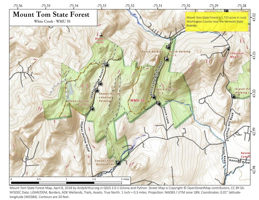
Mount Tom
Tomany Mountain
I was looking at this map and saw the lookout marked but I don't know anything about it - probably long gone as is the trail. I did find this blog post about it. https://hikingnyadirondacks.blogspot.com/2018/05/tomany-mountain-hike-for-piece-of-fire.html?m=1
Allegheny Front
The Allegheny Front stands as the prominent escarpment facing southeast or east within the Allegheny Mountains, spanning southern Pennsylvania, western Maryland, and eastern West Virginia in the USA. Serving as a demarcation, the Allegheny Front acts as the dividing line between the Ridge-and-Valley Appalachians to the east and the Appalachian Plateau (often referred to as the Allegheny Plateau) to the west. This geological feature is intimately linked with the Eastern Continental Divide of the Appalachian Mountains. In this region, the Eastern Continental Divide separates the watersheds of the Ohio/Mississippi river system, which flow towards the Gulf of Mexico, from those of rivers that eventually empty into Chesapeake Bay and further into the Atlantic Ocean.
Nonetheless, it's important to note that the Allegheny Front and the Divide don't always perfectly align. For instance, the North Branch of the Potomac River originates significantly west of the Allegheny Front, near the Fairfax Stone located at the southwestern tip of Maryland. It's merely around 10 miles (16 km) away and situated across the physical divide from the headwaters of the Youghiogheny River, which flows westward into the Monongahela and Ohio rivers.
Shelving Rock Mountain
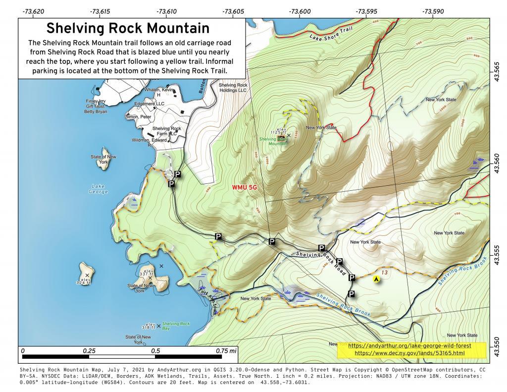
The Shelving Rock Mountain trail follows an old carriage road from Shelving Rock Road that is blazed blue until you nearly reach the top, where you start following a yellow trail. Informal parking is located at the bottom of the Shelving Rock Trail.
Harmon Rocks – North Fork Mountain
North Fork Mountain is a quartzite-capped mountain ridge in the Ridge and Valley physiographic province of the Allegheny Mountains (or "High Alleghenies" or "Potomac Highlands") of eastern West Virginia, USA. Kile Knob, at 4,588 feet (1,398 m), is the mountain's highest point, and Panther Knob and Pike Knob are nearly as high. North Fork Mountain is the driest high mountain in the Appalachians, and has vegetation and flora different from nearby, wetter high mountain areas immediately to the west such as Spruce Knob and Dolly Sods, with pines (Pinus) abundant on the mountain's ridgecrest, in contrast with the spruces (Picea) so characteristic of these comparably high summits across the North Fork Valley. https://en.wikipedia.org/wiki/North_Fork_Mountain
Albany – Buildings in the Contemporary Style
The other day I was making fun of NY State's assessor's manual very outdated description of buildings built-in the Contemporary Style. From page 68:
This classification is used to describe a dwelling style that is somewhat unique in structure. It is usually custom built with any variety of story heights from 1 to 2, varied rooflines, and is a structure given to open living with many combinations of the traditional room layouts. Large overhangs, split and drop floor levels, large amounts of fixed glass, and unique wood and stone facings typify these homes. The roof may be traditional, shallow or steep gable, flat, hip, mansard, or a unique combination of these. Dwellings of this style are normally considered to have a construction grade of Grade "A" - Excellent or Grade "B" - Good. An exception to this would be the A -Frame style house which usually has a construction grade of Grade "C" - Average or below.
Here is a map of all the Contemporary Buildings in the Albany area.