Search Results for: "Map:" Lowville

Lowville

I do find the hillshade to make even most boring map a little more attractive. Not all of New York has the LiDAR data in the 3D Elevation Program, like with Albany County, but a lot of places do, and it's far nicer then the traditional digital elevation models.

Lowville Forestry Demostration Area

The Lowville Forestry Demonstration Area is located on 98 acres at the former NYS Lowville Tree Nursery. The nursery was in operation from approximately 1923 to 1971 and during that time, a total of 530 million seedlings were produced. A demonstration forest was created here by planting trees together in blocks based on species. Demonstration forests are used to show how different species of trees grow and look together. https://www.dec.ny.gov/lands/8075.html

Black River Valley

Black River Valley

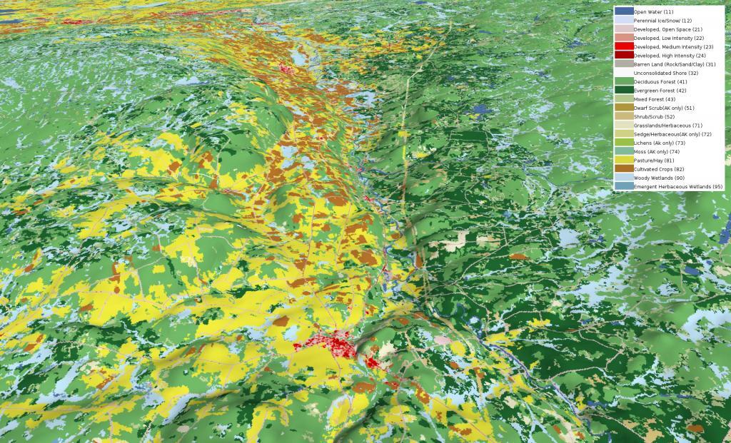
Looking at this 3D rendering of the Black River Valley, I never realized how nearly all the agriculture is on the west side of valley, climbing up into the Tug Hill Plateau. I am most of that has to do with the soils -- the east side is very sandy and infertile with a lot of timber stands. This picture starts around Boonville and heads north of Lowville, the town that rhythms with cow-ville for good reason.

Whetsone Gulf

Whetstone Gulf State Park is built in and around a three-mile-long gorge cut into the eastern edge of the Tug Hill Plateau outside of Lowville, New York.

Marks Dairy – 1995 vs 2018

Marks Dairy, located on the fertile plains of Black River is one of the biggest dairies in the state and became quite infamous for a while in early 2000s after a farming accident breached a manure storage pond leading to a massive fish kill in Black River for miles around Lowville. These false color infrared photos show the dairy in brilliant reds, due to the healthy legation from all the rich-manure and fertilization of the grounds, and excellent soils. I am not sure why the 1995 has those bright greens, they may have used a different type of false color imaging with the NAIP photos from the mid-1990s.

LEFT - Marks Dairy, circa 1995
RIGHT - Marks Dairy, circa 2018

The CAFOs of the Upper Black River Valley

CAFOs are mid-size (orange square) and large (brown square) dairies that have to manure management and water quality plans approved by the state to ensure they aren't over fertilizing fields and are controlling run off from their barnyards. Other farms are required to have CAFO permits, however dairy is the primary large-scale livestock industry in New York thanks to the state's cool and wet climate that is good for silage growing and dairy cow comfort. Click on boxes to pull up the farm record.

They say that Lowville rhythms with Cowville. The Black River Valley is known for it's fertile soils in narrow the strip between Tug Hill Plateau and Adirondack hill country of Independence River Wild Forest. The hicktown  of Lowville has all the smells of dairy country both good and pungent, haylage and silage, manure, and cattle more generally.

Marks Dairy, south of Lowville is one of the largest dairies in state, fed by thousands of acres of rich soil that are turned into silage, fed to cows, which are milked and turned into delicious cream cheese and other diary products. Lowville has the Cream Cheese festival every year, a product invented in Philadelphia, a few miles up the road.