Fort Valley is a mountain valley located primarily in Shenandoah County, Virginia. It is often called "valley within a valley" as it lies between the two arms of the northern part of the Blue Ridge mountain range in the Shenandoah Valley in the Ridge-and-Valley Appalachians geological zone.
Perched on a vantage point overlooking the Mohawk River, stands a grand mansion in the Georgian style, once the residence of General Nicholas Herkimer. This colonial frontier abode was meticulously constructed and completed circa 1764. General Herkimer etched his name in history during the pivotal year of 1777, when he rallied 800 militiamen alongside 60 Oneida warriors, marching resolutely to safeguard Fort Stanwix against a British siege.
The Battle of Oriskany, waged on August 6, 1777, marked a turning point in the Revolutionary War. It is recounted as one of the war's most harrowing conflicts, characterized by its intense bloodshed. Despite suffering a leg injury, Herkimer maintained steadfast command throughout the ferocious engagement. Following the battle, he was transported to his abode, where he succumbed to complications arising from the eventual amputation of his leg, ten days later.
Over the years, Herkimer's estate hosted a diverse array of inhabitants. This included his own family, enslaved individuals who contributed to the estate's operations, wartime encamped soldiers, and neighbors seeking sanctuary from the turmoil in the Mohawk Valley. The 19th century witnessed transformative changes on the property, as it bore witness to the passage of both the Erie Canal and subsequently the railroad, altering its landscape.
In the present day, easy access is granted to the site via highway, river, or the Canalway Trail. Visitors are extended a warm invitation to explore the mansion, engage with the exhibits in the visitor center, and wander the grounds. Here, they can discover the final resting place of General Herkimer, a meticulously recreated kitchen garden, vestiges of an Erie Canal lock, and picturesque vistas overlooking the serene Mohawk River.
The ramps off of the Dunn Memorial Bridge gracefully loop around as they drop down to the valley below. They are crossed by hundreds of construction and demolition debris and gasoline tanker trucks a day, and it's actually quite fortunate that there hasn't been any major crashes that have burned up the city or significantly polluted the river.
The causeway is an abandoned roadway that once spanned the lake. There’s a section that once had a bridge, which boaters now use to move back and forth between the southern and northern ends of the lake.
The bridge was washed out by high water and wind in 1929 and never replaced, according to Tony Geiss, deputy director of the Onondaga County Water Authority. The 100-yard area where people fish is located on the western side of the lake and is accessible from West Valley Road.
https://www.syracuse.com/outdoors/2012/06/cny_shoreline_hot_spots_the_ca.html
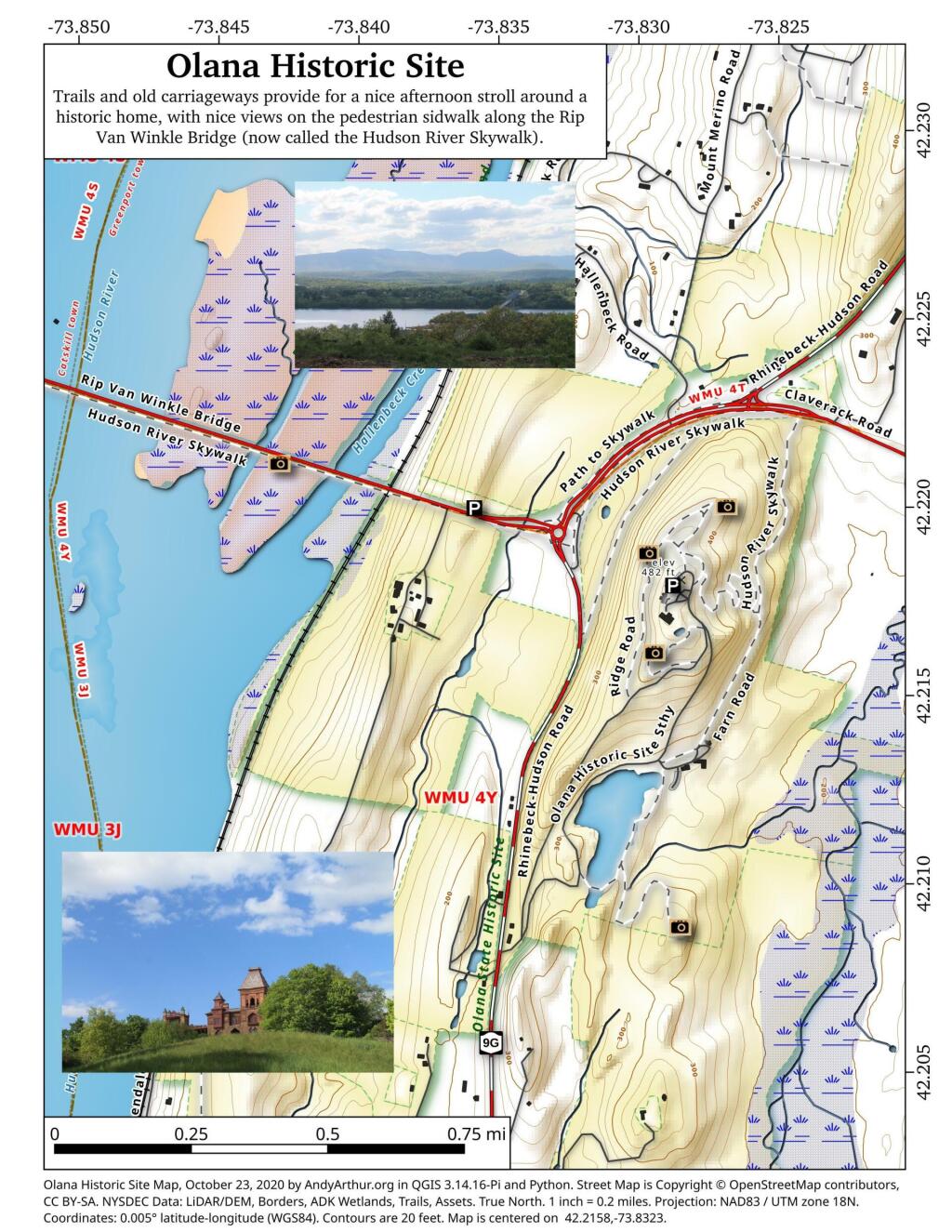
Olana State Historic Site was the home of Frederic Edwin Church (1826–1900), one of the major figures in the Hudson River School of landscape painting. The centerpiece of Olana is an eclectic villa composed of many styles, difficult to categorize, which overlooks parkland and a working farm designed by the artist. As well, the residence has a wide view of the Hudson River valley, the Catskill Mountains and the Taconic Range. Church and his wife Isabel (1836–1899) named their estate after a fortress-treasure house in ancient Greater Persia (modern-day Armenia), which also overlooked a river valley.
Good farmland is relatively uncommon in Northern West Virginia. But there is an exception around the valley in Fort Seybert.
CAFOs are mid-size (orange square) and large (brown square) dairies that have to manure management and water quality plans approved by the state to ensure they aren't over fertilizing fields and are controlling run off from their barnyards. Other farms are required to have CAFO permits, however dairy is the primary large-scale livestock industry in New York thanks to the state's cool and wet climate that is good for silage growing and dairy cow comfort. Click on boxes to pull up the farm record.
They say that Lowville rhythms with Cowville. The Black River Valley is known for it's fertile soils in narrow the strip between Tug Hill Plateau and Adirondack hill country of Independence River Wild Forest. The hicktown of Lowville has all the smells of dairy country both good and pungent, haylage and silage, manure, and cattle more generally.
Marks Dairy, south of Lowville is one of the largest dairies in state, fed by thousands of acres of rich soil that are turned into silage, fed to cows, which are milked and turned into delicious cream cheese and other diary products. Lowville has the Cream Cheese festival every year, a product invented in Philadelphia, a few miles up the road.
