The Butternut Interchange, where I-690 connects with Interstate 481 in the town of DeWitt, includes a pair of unused ramps and grading for additional connections with the unconstructed relocation of New York State Route 5. A 1965 proposal for a bypass of Fayetteville outlined a corridor extending southeast from I-690 and then I-281 along the right of way of the New York Central Railroad, Chenango branch to Route 92 at point near Oran.9 The Fayetteville Bypass was advanced by state officials at a luncheon on March 17, 1967, but without a tentative timetable. Coupled with a proposal to relocate Route 92 to the south of Manluis, the realignment of Route 5 was roughly projected to follow the old Erie Canal east.10 Ultimately neither Route 5, nor the four to six lane highway envisioned for Route 92 east from the Jamesville interchange with I-481 were constructed. Source: https://www.interstate-guide.com/i-690-ny/
While those are interesting connections how they are hooked into the interchange, I could see how this could become a weaving problem.
The idea of a Rotterdam–Glenville connector across the Mohawk River was proposed as early as the 1960s. Parts of the right-of-way of NY 890, including the bridges carrying what is now NY 890 over the ramp leading from NY 890 west to NY 5S, were built as part of I-890's construction in 1973. Construction of the remainder of the route was delayed for decades due to a lack of funds. Work on the highway finally resumed in 1996, and the length of NY 890 was opened to traffic in October 1998. https://en.m.wikipedia.org/wiki/New_York_State_Route_890
Mays Point is a hamlet in the Town of Tyre, Seneca County, New York near the Wayne and Cayuga county lines. It is located 7 miles northeast of the hamlet of Seneca Falls, at an elevation of 381 feet. The primary intersection in the hamlet is at N.Y. Route 89 and Mays Point Road. Lock 25 and the Mays Point Dam are central locations on this hamlet to the north of Montezuma Wildlife Refuge.
Plattsburgh could have had it's very own Lakefront Arterial in front of City Hall had the NYS Public Works Department gotten it's 1947 plan for the city.
https://babel.hathitrust.org/cgi/pt?id=nnc1.cu02334372&view=1up&seq=63
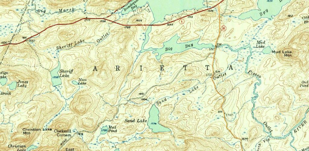
New York Route 10 is often said to be the last paved state highway in New York when the Glen Harris Highway was paved north of Arietta up through Piseco Lake in the early 1980s.
Due to constitutional constraints relating to the road running through forest preserve, with few exceptions, almost all of modern asphalt road follows the path of the dirt road, although during construction they did bank the curves and widen the road slightly from the horse and buggy road that existed in almost the same form since the 1800s.
I have the 1904 topographic maps of the area too but due to issues with the original map survey, the overlay is more difficult to do accurately compared to the more modern 1954 survey.
The modern alignment is shown in orange while the topographic map below is from 1954.
Earlton is a hamlet in Greene County, New York, United States. The community is located along New York State Route 81, 5 miles west of Coxsackie.
The 1938-era trus bridge that NY 28 uses to cross the Black River in Forestport will be closed this summer due to bridge replacement. 🚧 The 5,181 average daily traffic will have to take Hawkinsville Road (County Route 61) from NY 12 in Boonville to NY 28 in Woodgate to bypass the closure coming to and from the Adirondacks. Closed bridge is square blue box, click on box for full bridge data record.