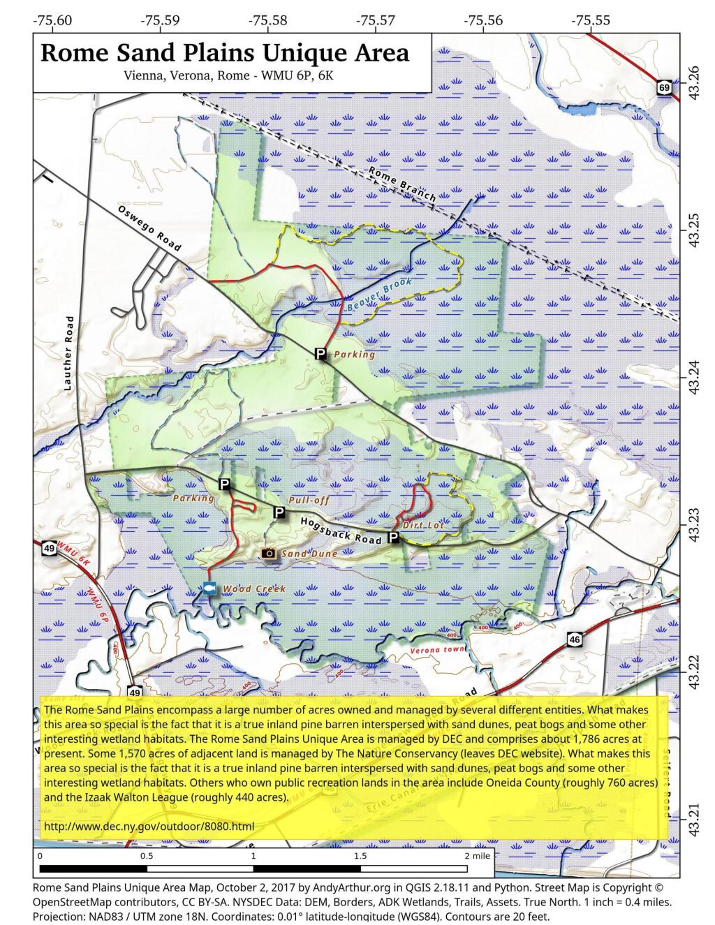
Map: Rome Sand Plains Unique Area
Download a High Resolution JPEG Image of the Rome Sand Plains Unique Area or an Adobe Acrobat Printable PDF of the Rome Sand Plains Unique Area.

Bookmark my free Interactive GPS Map for your phone:
https://andyarthur.org/ny
... shows your location as a blue dot in relationship to campsites, trails, state land. This online map requires cell service, won't work in remote country, so also bring a paper map.
Free Download of New & Historical USGS 1:24k Topograpic Maps
Interactive maps with backcountry and roadside camping: New York, Pennsylvania, West Virginia & Vermont. List of NYS DEC Lean-Tos and Firetowers.
Google Spreadsheet with Roadside, Primitive and Pay Campsites
More about Rome Sand Plains...
Rome Sand Plains is a 15,000-acre (61 km2) pine barrens consisting of a mosaic of sand dunes extending about 50 feet (15 m) above low peat bogs that lie between the dunes. The barrens are covered with mixed northern hardwood forests, meadows, and wetlands. The sand plains are about 5 miles (8.0 km) west of the city center of Rome, New York, which is in Oneida County; about 4,000 acres (16 km2) presently lie in conservation preserves. Pine barrens are typical of seacoasts; the Rome Sand Plains is one of only a handful of inland pine barrens remaining in the United States.
E. W. Russell has described the Sand Plains as follows, "The landscape today forms a sharp contrast with the surrounding flat, fertile farmland, which is almost all cleared of trees and planted in crops. Uplands, including some dunes, support forest vegetation of American beech, white oak (Quercus alba), red and sugar maples, white and pitch pine (Pinus strobus and P. rigida), gray birch (Betula populifolia), hemlock, aspen (Populus spp.), American elm, and other northern hardwood species. Some uplands are also characterized as pitch pine heaths, dominated by pitch pines with an understory of blueberries (Vaccinium spp.) and other related (ericaceous) shrubs. Pitch pine is the characteristic tree of the wetlands, along with aspen, gray birch, and red maple, along with an ericaceous shrub layer."
There are several rare species in the Sand Plains, including the purple pitcher plant and a sundew (both of which are carnivorous plants), red-shouldered hawks, martens, and the frosted elfin butterfly, which is a threatened species in New York State.[3] Other species to be found include wild blue lupine (also rare, and the food for the frosted elfin), barrens buckmoth (Hemileuca maia), whippoorwill, pine warbler and pitch pine, normally indigenous to coastal areas.
The Rome Sand Plains were owned privately through about 1980. The sand was mined to make molds and cores for metal casting. An application for a permit to mine sand around 1980 triggered an effort to protect the area. The New York State Department of Environmental Conservation began purchasing lands, working with The Nature Conservancy and other organizations. 1,700 acres (690 ha) of the Sand Plains have been purchased by the DEC, and are designated as the Rome Sand Plains Unique Area. The Nature Conservancy holds another 1,000 acres (400 ha). The Izaak Walton League holds about 440 acres (180 ha), Oneida County holds an additional 770 acres (310 ha) as a County Forest, and a few acres are held by the City of Rome. A map showing these holdings was released by the DEC in 2008; the map shows the location of three foot trails maintained by the DEC and one by the Izaak Walton League. A consolidated management plan involving all five preserves, and addressing the entire Sand Plains area, was released in 2006
http://en.wikipedia.org/wiki/Rome_Sand_Plains
http://www.dec.ny.gov/outdoor/8080.html
Maps and Interactives
Rome Sand Plains LIDAR
Rome Sand Plains Unique Area
... photos, maps and other content from from Rome Sand Plains.
