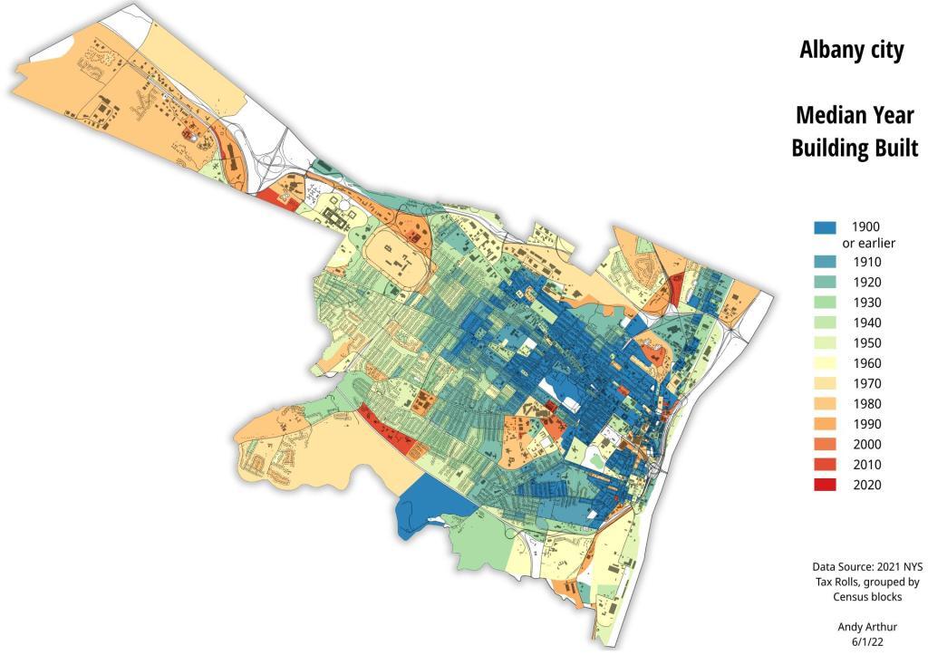
Thematic Map: Median Year Building Built, Albany County
Download a High Resolution JPEG Image of the Median Year Building Built, Albany County or an Adobe Acrobat Printable PDF of the Thematic Median Year Building Built, Albany County.
More about Albany County...
Albany County (/ˈɔːlbəniː/ awl-bə-nee) is a county located in the U.S. state of New York, and is part of the Albany-Schenectady-Troy Metropolitan Statistical Area. The name is from the title of the Duke of York and Albany, who became James II of England (James VII of Scotland). As of the 2010 census, the population was 304,204.[1] As originally established, Albany County had an indefinite amount of land, but has only 530 square miles (1,400 km2) as of March 3, 1888. The county seat is Albany, the state capital.
http://en.wikipedia.org/wiki/Albany_County,_New_York
Aerial Photos
Albany
Albany – A Plan for the Capital City (Downtown Albany 1980 Plan vs. Downtown Albany Today)
Albany (NY) The Battle In Lincoln Park
Albany 1978
Albany County Rail Trail
Albany Lumberyard (1857 vs. 2017)
Berne
Bozen Kill Gorge
Cario
Colonie Center (1952 vs. 2018)
Costcos (After vs. Before)
Crossgates 1970s (1973 vs. 1985)
Crossgates 1985
Delmar Bypass (1953 vs. 2019)
Don’t You Hate The Lack Of Parking At Colonie Center
Downtown Albany – June 12, 1951
East Karner Barrens 1973
Exit 5A to Nowhere
Fox Lair (1942 vs. 2017)
Karner East Barriens
LaFarge And Port Of Coeymans
Little Falls (1957 vs. 2017)
Little Falls and Moss Island 1957 in 3D
Mid-Crosstown Arterial Arbor Hill Section (1970 vs. 2016)
Onesquethaw
Original Dunn Bridge
Pastures – 1952
Patroon Island 1952
Plan for Albany 1794 (Overlay vs. Street Map)
Proposed Mid-Crosstown Arterial South of Washington Park (1970 vs. 2016)
Rapp Road Hog Farm Parcel
The Gut
The New Look of Transit Orriented Development
The Old Letter S
The State Office Building, 1948
Thruway Interchange 80s and 90s (1973 vs. 2018)
Tivoli Lake (1973 vs. 1995 vs. 2017)
Washington Avenue Extension (1973 vs. 2018)
White Birch Pond – Tubbs Pond – Fawn Lake (1960 vs. 2017)
Wolf Hill
Wolf Road 1952
Maps and Interactives
Wolf Road – 1952 vs Today
Winifred Matthews Holt Preserve
Wildlife Cuts – Partridge Run
White Birch Pond
West Albany Railyards, 1952
West Albany Railroad Yards – 1952 vs Today
Washington Park vs Northern Boulevard Interchange, a size comparison
Washington Park vs Lincoln Park, a size comparison
Washington Park
Upper Switz Kill Valley
Traffic Counts – Downtown Albany
Townsend Park and Nearby Areas 1952
Town of Colonie Zoning Districts
Town of Colonie, Buildings Built Since 2011
Timber Harvest for Wildlife
Thruway’s 1952 Ramps to New Scotland and Delaware Avenue
Thruway, 787 and 9W Interchange
Thompsons Lake
The Rain Has Arrived
The New York State Capitol
The Gulf
The Capital Region
Thacher Park OSI Parcel 1960
Tank Farm at Port of Albany
Switz Kill at Partridge Run
... photos, maps and other content from from Albany County.
