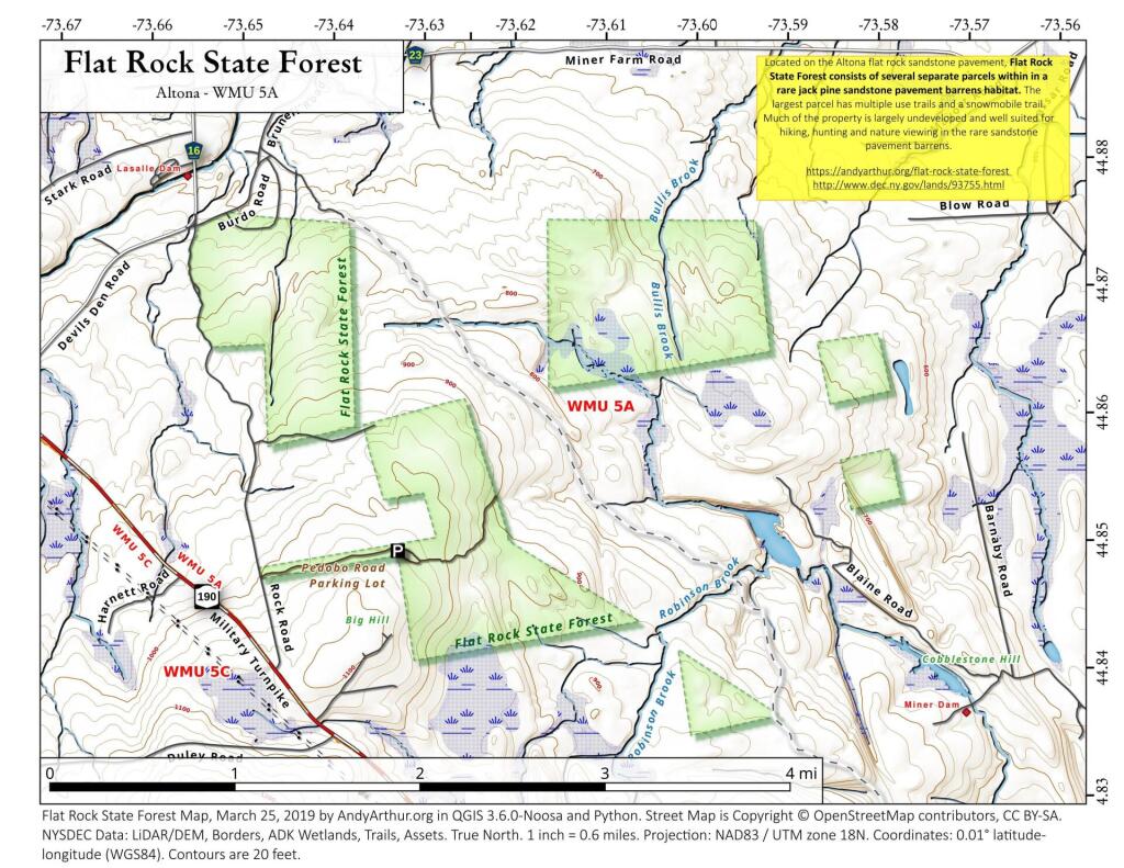
Map: Flat Rock State Forest
Download a High Resolution JPEG Image of the Flat Rock State Forest or an Adobe Acrobat Printable PDF of the Flat Rock State Forest.

Bookmark my free Interactive GPS Map for your phone:
https://andyarthur.org/ny
... shows your location as a blue dot in relationship to campsites, trails, state land. This online map requires cell service, won't work in remote country, so also bring a paper map.
Free Download of New & Historical USGS 1:24k Topograpic Maps
Interactive maps with backcountry and roadside camping: New York, Pennsylvania, West Virginia & Vermont. List of NYS DEC Lean-Tos and Firetowers.
Google Spreadsheet with Roadside, Primitive and Pay Campsites
More about Flat Rock State Forest...
Flat Rock State Forest is 1,931-acre (7.81 km2) a New York State Department of Environmental Conservation property located in Altona, New York.
It is home to a Sandstone Pavement Barrens. The Sandstone Pavement Barrens community is a narrow regional endemic that is possibly restricted to the northernmost counties of New York, north of the Adirondack Mountains in the northeastern portion of the Great Lakes Ecoregion, where the bedrock is sandstone.
The Sandstone Pavement Barrens is concentrated in the Champlain Valley of Clinton and Essex Counties where it reaches large patch size. Several small patch occurrences are reported from the Eastern Ontario and St. Lawrence Lowlands including islands in the Thousand Islands Region. Additional occurrences are suspected from within Lake George.
This community is possibly restricted to the northeastern portion of the Great Lakes Basin and parts of Maine. It may extend into Northern and Central Canada. The narrowly defined jack pine Pinus banksiana dominated barrens are known from northeastern New York, southern Quebec and Maine. Similar communities may also occur in Ontario, Minnesota, and Iowa.
Maps and Interactives
Flat Rock
Altona Flat Rock
Flat Rock State Forest
... photos, maps and other content from from Flat Rock State Forest.

1 Comment
Andy,
Your map is missing a lot of trails, man made structures and topographical features.
There are two other dams on the property. Skeleton Dam and another small dam probably less then a 1/4 of a mile from skeleton dam. There’s a fire tower, a lean to and a man made feature called the scar pit created when the Miner family tried to use concrete to stop water from leaking around million dollar dam. Trails circle the water features and one trail heads up to the devils den road from the ponds and passes by another small lake called the Dead Sea (surrounded by cliffs). There’s a bunch of other stuff back in there. The map you get at Hearts Delight Miners farm and the place where you get your permit to go on the property has most of the features on that map. Also see David Franzi’s paper
The Altona Flat Rock Jack Pine Barrens: A legacy of fire and Ice. Lawrence Gooley
also wrote a entire book on the history of the place.