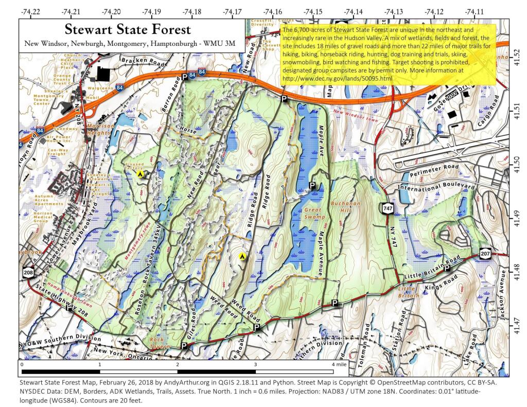
Map: Stewart State Forest
Download a High Resolution JPEG Image of the Stewart State Forest or an Adobe Acrobat Printable PDF of the Stewart State Forest.

Bookmark my free Interactive GPS Map for your phone:
https://andyarthur.org/ny
... shows your location as a blue dot in relationship to campsites, trails, state land. This online map requires cell service, won't work in remote country, so also bring a paper map.
Free Download of New & Historical USGS 1:24k Topograpic Maps
Interactive maps with backcountry and roadside camping: New York, Pennsylvania, West Virginia & Vermont. List of NYS DEC Lean-Tos and Firetowers.
Google Spreadsheet with Roadside, Primitive and Pay Campsites
More about Stewart State Forest...
The 6700-acres of Stewart State Forest are unique in the northeast and increasingly rare in the Hudson Valley. A mix of wetlands, fields and woods, the site includes 18 miles of gravel roads and over 22 miles of major trails which provide unparalleled recreation - hiking, biking, horseback riding, hunting, dog training and trials, skiing, snowmobiling, bird watching and fishing. Old farm fields take you to an earlier gentler time in our nation's history.
Hiking: Hiking is allowed on the property. Please see the attached map for trail locations. Please note that unless specifically posted as foot trails, all trails on the property are multiple use trails. Roadways on Stewart State Forest are accessible by car for people with disabilities, but a permit must first be obtained from DEC. Special arrangements must be made to obtain combinations for entry at selected gates.
Camping: Camping is only allowed by permit in specially designated group camping areas and must be greater than 150 feet from any trail, road or water body.
Snowmobiling: Allowed on designated trails.
Mountain biking: Allowed on designated trails or multiple use trails.
Horseback Riding: Allowed on all multiple use trails and roads.
http://www.dec.ny.gov/lands/50095.html
... photos, maps and other content from from Orange County, NY.
