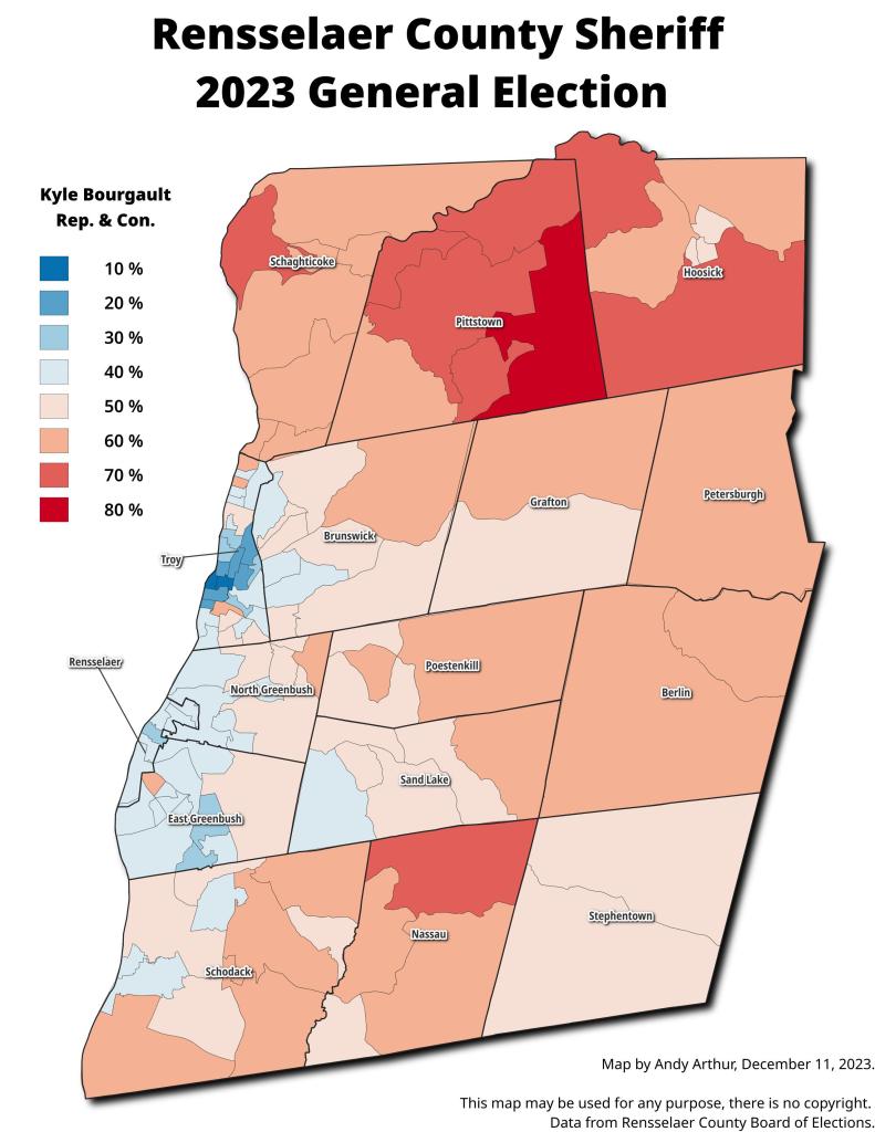
Thematic Map: Kyle Bourgault - Rensselaer County Sherriff 2023 General Election [Expires November 1 2024]
Download a High Resolution JPEG Image of the Kyle Bourgault - Rensselaer County Sherriff 2023 General Election [Expires November 1 2024] or an Adobe Acrobat Printable PDF of the Thematic Kyle Bourgault - Rensselaer County Sherriff 2023 General Election [Expires November 1 2024].
![High Resolution JPEG Image of the Kyle Bourgault - Rensselaer County Sherriff 2023 General Election [Expires November 1 2024]](/data/photo_009313_c.jpg)
More about Rensselear County...
Rensselaer County is a county in the U.S. state of New York. As of the 2010 census, the population was 159,429. Its county seat is Troy. It is part of the Albany-Schenectady-Troy Metropolitan Statistical Area.
Rensselaer County is in the eastern part of New York State. The eastern boundary of Rensselaer County runs along the New York–Vermont and New York–Massachusetts borders.
The terrain runs from level and flat near the Hudson and then rises into the Rensselaer Plateau around Poestenkill and Sand Lake, then to the Taconic Mountains along the Massachusetts state line.
The highest point is Berlin Mountain, 2,818 feet (859 m) above sea level, in the town of Berlin. The lowest point is sea level at the Hudson.
The Hoosic River, a tributary of the Hudson River, is in the north part of the county.
http://en.wikipedia.org/wiki/Rensselaer_County,_New_York
Maps and Interactives
West Sand Lake Gravel Mine
Van Rensselaer Square vs Empire Plaza – A Size Comparison
Van Rensselaer Square – 1995, 2000, 2004, 2007, 2011, 2014, 2017, 2021
The Old Dunn Bridge
Taconic Trail Wanders Through the Tibbits State Forset
SA Dunn Landfill – April 2021
SA Dunn Landfill
Rensselaer Railyards 1952
Rennselear Environmental Justice Zone
Port of Rensselear – 1928
Menands Bridge in 1952
Hoosick Falls, New York
Empire Generating Plant
Dunn Memorial Bridge Ramps
Dunn Bridge 1952
Dewey Loefell Landfill
Before and After Exit 8
BASF – Port of Rensslear 1952
Averill Park Aerials – 2000, 2004, 2007, 2011, 2014, 2017, 2021
Rensselaer County Subwatersheds
Kyle Bourgault – Rensselaer County Sherriff 2023 General Election [Expires November 1 2024]
Rensselaer Plateau
Tibbitts State Forest
... photos, maps and other content from from Rensselear County.