| State Land |
Road |
Miles |
| Albert J. Woodford Memorial State Forest |
Truck Trail |
0.7 |
| Albert J. Woodford Memorial State Forest |
Janis Road |
1.1 |
| Aldrich Pond Wild Forest |
Powell Road |
0.5 |
| Aldrich Pond Wild Forest |
Mullins Flow Road |
0.6 |
| Aldrich Pond Wild Forest |
Little River Road |
0.7 |
| Aldrich Pond Wild Forest |
Silver Dawn Road |
0.7 |
| Aldrich Pond Wild Forest |
Jackworks Trail |
1.1 |
| Aldrich Pond Wild Forest |
South Creek Lake Road |
1.6 |
| Aldrich Pond Wild Forest |
Tyler Road |
3.7 |
| Aldrich Pond Wild Forest |
Streeter Lake Road |
4.8 |
| Allen Lake State Forest |
George Forest Road |
1.5 |
| Ambler State Forest |
Truck Trail |
1.8 |
| Ampersand Primitive Area |
Ampersand Park Road |
3.2 |
| Andersen Hill State Forest |
Big Pine Public Forest Acess Road |
1.5 |
| Arctic China State Forest |
China Public Forest Access Road |
1.1 |
| Arctic China State Forest |
Shears Public Forest Access Road |
2 |
| Arctic China State Forest |
Dunbar Public Forest Access Road |
2.1 |
| Armlin Hill State Forest |
Truck Trail |
1.1 |
| Arnold Lake State Forest |
Public Forest Access Road |
0.9 |
| Arnold Lake State Forest |
Hartwick Forest Access Road |
1 |
| Ashland Pinnacle State Forest |
Ashland Pinnacle Access Road #2 |
0.5 |
| Ashland Pinnacle State Forest |
Haul Road #1/Long Path Hiking Trail |
1.4 |
| Avon Regional Office |
Goodlake Year Entrance Road |
0.7 |
| Baker School House State Forest |
Baker School House Public Forest Acess Road |
1.8 |
| Bald Mountain State Forest |
Howe Forest Road |
2.4 |
| Balsam Creek State Forest |
Briar Hill Road |
1.5 |
| Barbour Brook State Forest |
Barbour Brook Public Forest Access Road |
2 |
| Basswood State Forest |
Burlington Public Forest Access Road |
0.5 |
| Basswood State Forest |
Basswood Pond Public Forest Access Road |
1 |
| Basswood State Forest |
Dr. Crouch Truck Trail |
1.3 |
| Bates State Forest |
Pucker Street |
1 |
| Bates State Forest |
Bates Forest Road |
2.6 |
| Battle Hill State Forest |
Unnamed |
1.3 |
| Bear Pond Primitive Area |
Bear Pond Road |
0.8 |
| Bear Swamp State Forest |
Karsch Haul Road |
0.5 |
| Bear Swamp State Forest |
Joe Chamberlin Public Forest Access Road |
1.6 |
| Bear Swamp State Forest |
Roseboom Public Facility Truck Trail |
1.8 |
| Bear Swamp State Forest |
Snowmobile Trail |
8.3 |
| Bearpen Mountain State Forest |
Ski Run Road |
2.1 |
| Beartown State Forest |
Town Road |
0.7 |
| Beartown State Forest |
Cotton Road |
0.8 |
| Beartown State Forest |
Steam Mill Road |
0.8 |
| Beartown State Forest |
Aspen Hollow Road |
2.4 |
| Beaver Creek State Forest |
Public Forest Access Road 2, Madison 11 |
0.5 |
| Beaver Creek State Forest |
Truck Trail -2-12 |
0.7 |
| Beaver Creek State Forest |
Public Forest Access Road 1, Madison 11 |
1.3 |
| Beaver Creek State Forest |
Truck Trail -1-12 |
3.6 |
| Beaver Dam State Forest |
Sears Public Forest Acess Road |
1.4 |
| Beaver Meadow State Forest |
Weir Dam Truck Trail |
0.5 |
| Beebe Hill State Forest |
Barrett Pond Road |
1.4 |
| Beebe Hill State Forest |
Loop Road |
2.3 |
| Big Brook State Forest |
County Line Road Spur |
0.6 |
| Big Brook State Forest |
Walasek Mulcoy Road |
0.8 |
| Big Brook State Forest |
Hanifin Road |
0.9 |
| Big Brook State Forest |
County Line Road |
1.4 |
| Birdseye Hollow State Forest |
Sanford Lake Access Road |
0.5 |
| Black Creek State Forest |
Stanley Road |
1.1 |
| Black River Wild Forest |
Remsen Falls Trail |
0.5 |
| Black River Wild Forest |
Woods Lake Road |
0.5 |
| Black River Wild Forest |
Gull Lake Road |
0.6 |
| Black River Wild Forest |
Flansburg Road |
0.7 |
| Black River Wild Forest |
Party Road |
0.7 |
| Black River Wild Forest |
Black Creek Road |
0.8 |
| Black River Wild Forest |
Cohen Road |
1.7 |
| Black River Wild Forest |
Flansberg Road |
2.6 |
| Black River Wild Forest |
Black Creek Lake Road |
3 |
| Black River Wild Forest |
Haskell Road |
3 |
| Black River Wild Forest |
Mill Creek Road |
3.4 |
| Black River Wild Forest |
Nicks Lake Campground Roads |
3.5 |
| Black River Wild Forest |
Wolf Lake Landing Road |
4.8 |
| Black River Wild Forest |
West Creek Road |
6.3 |
| Blenheim Hill State Forest |
Ward Allen Road |
1.1 |
| Blenheim Hill State Forest |
Quarry Road |
1.2 |
| Blue Mountain Wild Forest |
Deer Pond Road |
1.1 |
| Blue Mountain Wild Forest |
Chain Lakes Road North |
1.3 |
| Blue Mountain Wild Forest |
Polaris Road |
1.3 |
| Bombay State Forest |
Cross Haul Road |
0.7 |
| Bombay State Forest |
Railroad Bed Public Forest Acess Road |
1.2 |
| Bombay State Forest |
Pike Brook Haul Road |
3.1 |
| Bonaparte’s Cave State Forest |
Corbine Road |
0.8 |
| Bonaparte’s Cave State Forest |
Mud Pond Road |
0.8 |
| Boutwell Hill State Forest |
Arab Hill Forest Road, Cha 1 Section |
0.8 |
| Boutwell Hill State Forest |
Arab Hill Forest Road, Cha 7 Section |
2.1 |
| Boyce Hill State Forest |
Jackson Forest Road |
0.6 |
| Brasher State Forest |
Route 53 Haul Road |
0.5 |
| Brasher State Forest |
Beaver Pond Trail |
0.6 |
| Brasher State Forest |
Kennehan Haul Road |
0.8 |
| Brasher State Forest |
Bush Road |
1.1 |
| Brasher State Forest |
Buckley Haul Road |
1.2 |
| Brasher State Forest |
Cc Dam Public Forest Access Road |
1.2 |
| Brasher State Forest |
Mccarthy Public Forest Access Road |
1.6 |
| Brasher State Forest |
Liberty Public Forest Access Road |
1.7 |
| Brasher State Forest |
Hastings Falls Haul Road |
2.1 |
| Brasher State Forest |
Wilson Public Forest Access Road |
2.1 |
| Brasher State Forest |
Camp / Larue Public Forest Access Road |
2.2 |
| Brasher State Forest |
Pascal Haul Road |
2.4 |
| Brasher State Forest |
Bush Public Forest Access Road |
2.9 |
| Brasher State Forest |
Railroad Bed Public Forest Access Road |
3.6 |
| Brokenstraw State Forest |
Brokenstraw Forest Road |
1.7 |
| Bryant Hill State Forest |
Hawk Forest Road |
1.4 |
| Buck Hill State Forest |
Hertz Road |
0.7 |
| Buck Hill State Forest |
Truck Trail |
1.5 |
| Buck Hill State Forest |
Buck Hill Road |
3.1 |
| Bucks Brook State Forest |
Access Trail |
0.6 |
| Buckton State Forest |
Buckton Haul Road |
0.8 |
| Bucktooth State Forest |
Baily Hollow Forest Road |
0.6 |
| Bucktooth State Forest |
Manley Hill Forest Road |
1 |
| Bully Hill State Forest |
Dixon Forest Road |
1 |
| Bully Hill State Forest |
Connection Forest Road |
1.6 |
| Bully Hill State Forest |
Stearns Forest Road |
2.1 |
| Burnt-Rossman Hills State Forest |
Koenig Road |
0.5 |
| Burnt-Rossman Hills State Forest |
Betty Brook Haul Road |
0.6 |
| Burnt-Rossman Hills State Forest |
Eminence Dead End Truck Trail |
0.7 |
| Burnt-Rossman Hills State Forest |
Duck Pond Road |
1.2 |
| Burnt-Rossman Hills State Forest |
Monkey Run Truck Trail East |
1.3 |
| Burnt-Rossman Hills State Forest |
Yankee Street Truck Trail |
1.3 |
| Burnt-Rossman Hills State Forest |
Betty Brook Road |
1.4 |
| Burnt-Rossman Hills State Forest |
Betty Brook Truck Trail |
1.5 |
| Burnt-Rossman Hills State Forest |
Duck Pond Truck Trail |
1.5 |
| Burnt-Rossman Hills State Forest |
Morey Road Truck Trail |
1.7 |
| Burnt-Rossman Hills State Forest |
Eminence Road Truck Trail |
2.6 |
| Burnt-Rossman Hills State Forest |
Burnt Hill Road |
2.9 |
| Bush Hill State Forest |
Fox Cross Forest Road |
2 |
| California Hill State Forest |
Wayawanda Road |
0.7 |
| Canacadea State Forest |
Macduff Road |
2.3 |
| Canadaway Creek Wma |
Dibble Hill Forest Road |
2 |
| Canaseraga State Forest |
Ringelberg Truck Trail |
0.5 |
| Canaseraga State Forest |
Right Fork Truck Trail |
1 |
| Canaseraga State Forest |
Stanley Road |
1.1 |
| Canaseraga State Forest |
Left Fork Truck Trail |
1.4 |
| Caroga Lake Campground |
Campground Road |
2 |
| Catherineville State Forest |
Santamont Access Trail |
1.1 |
| Catherineville State Forest |
Circle Public Forest Access Road |
1.8 |
| Charles E. Baker State Forest |
Truck Trail 5 |
0.6 |
| Charles E. Baker State Forest |
Truck Trail 2 |
0.9 |
| Charles E. Baker State Forest |
Truck Trail 6 |
0.9 |
| Charles E. Baker State Forest |
Truck Trail 4 |
1.4 |
| Charles E. Baker State Forest |
Truck Trail 12 |
1.5 |
| Charles E. Baker State Forest |
Truck Trail 8 |
1.9 |
| Charles E. Baker State Forest |
Truck Trail 7 |
2.1 |
| Charles E. Baker State Forest |
Truck Trail 1 |
3 |
| Charles E. Baker State Forest |
Truck Trail 13 |
3.2 |
| Chazy Highlands State Forest |
Spring Road |
0.6 |
| Cherry Valley State Forest |
Kniskern Public Access Road |
1.2 |
| Cherry Valley State Forest |
Mosse Public Forest Access Road |
1.9 |
| Cinnamon Lake State Forest |
Hornby Road Haul Road |
0.7 |
| Clapper Hollow State Forest |
Clapper Hollow Truck Trail |
1 |
| Clark Hill State Forest |
Abandoned Town Road |
0.8 |
| Clark Hill State Forest |
Truck Trail |
0.9 |
| Clark Hill State Forest |
Access Road North Of Buck Hill Road |
0.9 |
| Clark Hill State Forest |
Class A Truck Trail |
1.2 |
| Clark Hill State Forest |
Haul Road |
1.3 |
| Cliffside State Forest |
Railroad Haul Road |
1.3 |
| Cobb Brook State Forest |
Unnamed Truck Trail |
0.6 |
| Cold Creek State Forest |
Headwaters Forest Road |
1.4 |
| Cold Spring Brook State Forest |
Cold Spring Brook Public Forest Access Road |
1.9 |
| Cole Hill State Forest |
Cr 2 Access Road |
0.8 |
| Coyle Hill State Forest |
Warner Spur Forest Road |
0.5 |
| Coyle Hill State Forest |
Slawson Forest Road |
0.8 |
| Coyle Hill State Forest |
Warner Forest Road |
1.8 |
| Cranberry Lake Campground |
Campground Road |
2.5 |
| Cranberry Lake Wild Forest |
Grass River Railroad |
6.1 |
| Cuyler Hill State Forest |
Jipson Hill Public Forest Acess Road |
1.3 |
| Cuyler Hill State Forest |
Cuyler Hill Public Forest Acess Road |
5.1 |
| David A. Sarnoff Preserve |
Field Access Road |
0.8 |
| Debar Mountain Wild Forest |
Debar Game Refuge Road |
0.5 |
| Debar Mountain Wild Forest |
Debar Meadow Road |
0.6 |
| Debar Mountain Wild Forest |
Vanderwalker Road |
0.9 |
| Debar Mountain Wild Forest |
4 Mile Road Riffle Season Access Corridor |
1.1 |
| Debar Mountain Wild Forest |
Ny Centrail Railroad Bed |
2.2 |
| Deer River State Forest |
Ccc Road |
0.6 |
| Deer River State Forest |
Hogsback Road |
0.6 |
| Deer River State Forest |
Willow Road |
0.6 |
| Deer River State Forest |
Glaze Road |
0.7 |
| Deer River State Forest |
Avery Lot Road |
0.9 |
| Deer River State Forest |
Esseltine Hill Road |
0.9 |
| Deer River State Forest |
Ricky’s Number Trail |
1 |
| Deer River State Forest |
Horse Barn Road |
1.2 |
| Deer River State Forest |
Laramie Road |
1.3 |
| Deer River State Forest |
Beanville Road |
1.4 |
| Deer River State Forest |
Spruce Road |
1.6 |
| Deer River State Forest |
Loope Road |
2 |
| Deer River State Forest |
Firewood Road |
2.6 |
| Degrasse State Forest |
Burns Flats Road |
0.5 |
| Degrasse State Forest |
Loop Road |
1.2 |
| Deruyter State Forest |
Tromp Road |
1.5 |
| Dobbins Memorial State Forest |
Snowmobile Trail |
3.5 |
| Dog Hollow State Forest |
Brewer Public Forest Acess Road |
0.9 |
| Downerville State Forest |
River Public Forest Access Road |
1 |
| Dry Run State Forest |
Wildcat Hollow |
0.8 |
| Dunkin’s Reserve State Forest |
Access Road |
3.5 |
| Dutch Settlement State Forest |
Haul Road #1 |
0.6 |
| Dutton Ridge State Forest |
Dutton Ridge Access Road |
1.5 |
| Earlville State Forest |
Mad 2 Forest Access Road |
1.5 |
| East Osceola State Forest |
Malloy Brook Road |
1.1 |
| East Otto State Forest |
Kriedeman Forest Road |
1.7 |
| Edgewood Oak Brush Plains Preserve |
Edgewood Oak Brush Plains Preserve |
0.5 |
| Edgewood Oak Brush Plains Preserve |
Unpaved Forest Road |
0.5 |
| Edgewood Oak Brush Plains Preserve |
Old Commack Road |
1.6 |
| English Hill State Forest |
Ricketts Forest Road |
0.9 |
| Exeter State Forest |
Exeter Public Forest Access Road |
1.3 |
| Fairfield State Forest |
Jenksville Hill Public Forest Acess Road |
2 |
| Fall Brook State Forest |
Gossner Road |
0.6 |
| Fall Brook State Forest |
Haul Road To B-45 Wetland |
0.9 |
| Fall Brook State Forest |
Access Road From Co. Rt 67A |
1 |
| Fall Brook State Forest |
Forest Access Roaad |
1.2 |
| Ferris Lake Wild Forest |
Meco Lake Trail |
0.9 |
| Ferris Lake Wild Forest |
Sheriff Lake Trail |
0.9 |
| Ferris Lake Wild Forest |
Mud Lake Road |
5.5 |
| Fish Creek State Forest |
Forward Road |
0.5 |
| Fish Creek State Forest |
Trestle Road |
0.6 |
| Fish Creek Wma |
State Highway 184 Access Road |
0.9 |
| Five Rivers Education Center |
Goose Lane |
0.5 |
| Flat Rock State Forest |
Pedobo Road |
0.8 |
| Flat Rock State Forest |
Karsch Haul Road |
0.9 |
| Flat Rock State Forest |
Ampersand Park Road |
1.9 |
| Florence Hill State Forest |
Florence Hill Road |
1.9 |
| Fort Jackson State Forest |
Sheldon Public Forest Access Road |
0.5 |
| Frank E. Jadwin Memorial State Forest |
Keesler Road |
0.6 |
| Frank E. Jadwin Memorial State Forest |
Old Croghan Road |
0.7 |
| Frank E. Jadwin Memorial State Forest |
Henry Road |
0.8 |
| Frank E. Jadwin Memorial State Forest |
Nelson Road |
0.8 |
| Frank E. Jadwin Memorial State Forest |
Wahalula Road |
0.8 |
| Frank E. Jadwin Memorial State Forest |
Q- Road |
1.5 |
| Frank E. Jadwin Memorial State Forest |
Patchin Road |
1.7 |
| Frank E. Jadwin Memorial State Forest |
Blanchard Creek Road |
2.7 |
| Frank E. Jadwin Memorial State Forest |
Wisner Road |
2.7 |
| Frank E. Jadwin Memorial State Forest |
Judy Cole Road |
2.8 |
| Frank E. Jadwin Memorial State Forest |
Loop Road |
3.2 |
| Fulton Chain Wild Forest |
Cary Lake Road |
1.8 |
| Furnace Creek State Forest |
Miller Road East |
0.7 |
| Furnace Creek State Forest |
Powerline Row |
0.7 |
| Furnace Creek State Forest |
Sheehan Road |
1.2 |
| Furnace Creek State Forest |
B-29 Road |
1.4 |
| Gates Hill State Forest |
Coons Den Truck Trail |
0.6 |
| Gates Hill State Forest |
Eviann Road |
1.2 |
| Genegantslet State Forest |
South Loomis Road |
0.7 |
| Gillies Hill State Forest |
Abbey Forest Road |
0.9 |
| Gillies Hill State Forest |
Pettit Forest Road |
1.4 |
| Golden Hill State Forest |
Firelane Forest Road |
1.6 |
| Goundry Hill State Forest |
Guiren Road |
1 |
| Goundry Hill State Forest |
Corbett Hollow Access Road |
1.1 |
| Grant Powell State Forest |
Huck Berry Road |
2.1 |
| Grass River Wild Forest |
Spruce Mountain Road |
0.8 |
| Grass River Wild Forest |
Hollywood Road |
2.5 |
| Grass River Wild Forest |
Railroad Grade Road |
2.9 |
| Greenwood Creek State Forest |
Grass Pond Public Forest Access Road |
0.9 |
| Grigg’s Gulf State Forest |
Grigg’s Gulf Public Forest Acess Road |
1.5 |
| Gulf Unique Area |
Gulf R.O.W. Road |
0.5 |
| Gulf Unique Area |
Old Skid Road |
1.1 |
| Hall Island State Forest |
Unnamed Public Forest Acess Road |
0.7 |
| Hammond Hill State Forest |
Redman Run Public Forest Acess Road |
1.1 |
| Hammond Hill State Forest |
Cannan Public Forest Acess Road |
1.3 |
| Hammond Pond Wild Forest |
Paynes Way |
0.7 |
| Harris Hill State Forest |
Sprague Forest Road |
0.8 |
| Harvey Mountain State Forest |
Harvey Mt Access Road |
0.9 |
| Harvey Mountain State Forest |
East Hill Access Road |
2.4 |
| Hatch Creek State Forest |
Hodge Forest Road |
0.6 |
| Hatch Creek State Forest |
North Forest Road |
0.8 |
| Hatch Creek State Forest |
South Forest Road |
0.9 |
| Hemlock-Canadice State Forest |
South Hemlock Access Road |
0.7 |
| Henderson Shores Unique Area |
Radar Road |
0.8 |
| Hewitt State Forest |
Hewitt Rd |
1.1 |
| Hickok Brook Multiple Use Area |
Spur Road |
0.7 |
| Hickok Brook Multiple Use Area |
Main Road |
1.1 |
| High Flats State Forest |
Chapel Hill Access Trail |
0.5 |
| High Flats State Forest |
Crowley Access Trail |
0.5 |
| High Flats State Forest |
Close Pond Access Trail |
0.7 |
| High Flats State Forest |
Donovan Public Forest Access Road |
1.1 |
| High Knob State Forest |
Shale Pit Road |
1.9 |
| High Peaks Wilderness |
Northville-Placid Trail-Northern Terminus |
1.1 |
| Hill Higher State Forest |
Hill Higher Forest Road |
1.1 |
| Hinckley State Forest |
Elm Flats Road |
0.5 |
| Hinckley State Forest |
Roberts Road |
0.5 |
| Hinckley State Forest |
Lanning Road |
0.8 |
| Hinckley State Forest |
Access Road |
1.6 |
| Hinckley State Forest |
Black Creek Road |
2 |
| Hogsback State Forest |
Forest Access Road |
3 |
| Honey Hill State Forest |
Edwards Public Forest Access Road |
1.4 |
| Hooker Mountain State Forest |
Norton Public Forest Access Road |
0.8 |
| Horseshoe Lake Wild Forest |
Cut Off Road |
0.6 |
| Horseshoe Lake Wild Forest |
Lower Dam Road |
0.7 |
| Horseshoe Lake Wild Forest |
Otter Brook Trail |
0.9 |
| Horseshoe Lake Wild Forest |
Grass River Railroad |
1.7 |
| Horseshoe Lake Wild Forest |
Otter Brook Road |
2.2 |
| Hoxie Gorge State Forest |
Russel Hill Public Forest Acess Road |
2.5 |
| Huntersfield State Forest |
Huntersfield Access Road #2 |
0.7 |
| Huntersfield State Forest |
Huntersfield Access Road #1 |
1.9 |
| Hunts Pond State Forest |
Truck Trail |
1.7 |
| Independence River State Forest |
Assembly Road |
1 |
| Independence River Wild Forest |
Blue Jog Road |
0.5 |
| Independence River Wild Forest |
Sunday Lake Road |
0.5 |
| Independence River Wild Forest |
Evies Pond Road |
0.7 |
| Independence River Wild Forest |
Burnt Creek Road |
0.7 |
| Independence River Wild Forest |
Elbow Rd |
0.7 |
| Independence River Wild Forest |
Shortcut Road |
0.8 |
| Independence River Wild Forest |
Fish Pond Road |
1 |
| Independence River Wild Forest |
Halfmoon Lake Rd |
1 |
| Independence River Wild Forest |
Little Otter Creek Road |
1 |
| Independence River Wild Forest |
Long Pond Spur |
1 |
| Independence River Wild Forest |
East Loop Road |
1.1 |
| Independence River Wild Forest |
Copper Lake Road |
1.2 |
| Independence River Wild Forest |
Necessary Dam Road |
1.2 |
| Independence River Wild Forest |
Pitcher Pond Road |
1.3 |
| Independence River Wild Forest |
Hinchings Pond Road |
1.8 |
| Independence River Wild Forest |
Basket Factory Road |
2.1 |
| Independence River Wild Forest |
Catspaw Lake Road |
2.4 |
| Independence River Wild Forest |
Confusion Flats Road |
2.6 |
| Independence River Wild Forest |
Big Otter Lake Road |
3.1 |
| Independence River Wild Forest |
Stony Lake Road |
3.1 |
| Independence River Wild Forest |
Florence Pond Road |
3.1 |
| Independence River Wild Forest |
Steam Mill Road |
3.5 |
| Independence River Wild Forest |
Smith Road |
3.7 |
| Indian Pipe State Forest |
Dunes Road |
0.7 |
| Indian River Wma |
Red Lake Road |
2 |
| Jackson Hill State Forest |
Forest Access Road |
2.1 |
| Jersey Hill State Forest |
Scholes Forest Road |
1.6 |
| Jessup River Wild Forest |
Lake Colby Camp Road |
0.7 |
| Karr Valley Creek State Forest |
Frungillo Forest Road |
0.8 |
| Karr Valley Creek State Forest |
Norton Forest Road |
1.3 |
| Karr Valley Creek State Forest |
Davison Forest Road |
1.4 |
| Keeney Swamp State Forest |
Fitch Hill Spur Forest Road |
0.7 |
| Keeney Swamp State Forest |
C3D |
0.8 |
| Keeney Swamp State Forest |
Fitch Hill Forest Road |
1.2 |
| Keeney Swamp State Forest |
Gordon Forest Road |
1.4 |
| Kennedy State Forest |
Courtney Hill Public Forest Acess Road |
0.7 |
| Kennedy State Forest |
Cotton-Hanlon Public Forest Acess Road |
1 |
| Kennedy State Forest |
Kennedy Public Forest Acess Road |
2.5 |
| Kenneth Wilson Campground |
Campground Road |
9.7 |
| Ketchumville State Forest |
Ketchumville Public Forest Acess Road |
1 |
| Keyserkill State Forest |
Guinea Road Truck Trail |
1 |
| Keyserkill State Forest |
Keyserkill Truck Trail #1 |
1.3 |
| Klipnocky State Forest |
Emery Forest Road |
1.2 |
| Klipnocky State Forest |
Marble Forest Road |
1.6 |
| Klondike State Forest |
Klondike Public Forest Acess Road |
1.7 |
| Lafayetteville Multiple Use Area |
Wilbur Flats Road |
0.9 |
| Lake Durant Campground |
Scott Public Forest Acess Road |
0.9 |
| Lake George Wild Forest |
Jabe Pond Road |
1 |
| Lake George Wild Forest |
Dacy Clearing Road |
1.6 |
| Lake George Wild Forest |
Lily Pond Road |
2.1 |
| Lake George Wild Forest |
Gay Pond Road |
4 |
| Lake Harris Campground |
Campground Road |
0.9 |
| Lakeview Marsh Wma |
Skinner Road |
0.7 |
| Leonard Hill State Forest |
Leonard Hill Access Road #1 |
0.7 |
| Leonard Hill State Forest |
Leonard Hill Access Road #3 |
1.2 |
| Leonard Hill State Forest |
Leonard Hill Access Road #2 |
1.6 |
| Lesser Wilderness State Forest |
Gomer Hill Road |
0.5 |
| Lesser Wilderness State Forest |
Toole Road |
0.6 |
| Lesser Wilderness State Forest |
Alguire Road |
0.7 |
| Lesser Wilderness State Forest |
Smith Road |
0.8 |
| Lesser Wilderness State Forest |
Nob Road |
0.9 |
| Lesser Wilderness State Forest |
Seelman Road |
1.3 |
| Lesser Wilderness State Forest |
Mcgoldrick Road |
3 |
| Lesser Wilderness State Forest |
#9 Road |
4.7 |
| Limekiln Lake Campground |
Lime Kiln Lake Campground Trails |
3.9 |
| Linda Gronlund Memorial At Barcelona Neck |
Trustee Road West |
1 |
| Linda Gronlund Memorial At Barcelona Neck |
Trustee Road East |
1.7 |
| Lonesome Bay State Forest |
Alamogin Public Forest Access Road |
2.2 |
| Long Pond State Forest |
Access Road |
0.5 |
| Long Pond State Forest |
Truck Trail |
0.7 |
| Long Pond State Forest |
Long Pond Snowmobile Trail |
0.8 |
| Lookout State Forest |
Ball Road |
0.6 |
| Lost Nation State Forest |
Brookdale Road / Jenkins Corners Rd / Red Barn Rd |
2.5 |
| Lost Valley State Forest |
Lost Valley Haul Road |
1.2 |
| Lowville Demonstration Area |
Dadville Road |
0.6 |
| Ludlow Creek State Forest |
Trail Road |
1.3 |
| Lutheranville State Forest |
Access Road #1 |
0.5 |
| Lutheranville State Forest |
Access Road #2 |
1.2 |
| Lyon Brook State Forest |
Lyon Brook Truck Trail |
1.2 |
| Mad River State Forest |
Thompson Corners Florence Road |
0.5 |
| Mad River State Forest |
Bartlett Road |
0.6 |
| Mad River State Forest |
Rehm Road |
0.6 |
| Mad River State Forest |
Phalen Road South |
1.9 |
| Mad River State Forest |
Mcspirit Road |
2.1 |
| Madawaska Flow – Quebec Brook Primitive Area |
Benz Pond Road |
2.2 |
| Mallet Pond State Forest |
Cemetery Road Truck Trail |
2 |
| Maxon Creek State Forest |
Pease Hill Public Forest Acess Road |
1 |
| Mccarthy Hill State Forest |
Main Access Road |
0.5 |
| Mccarty Hill State Forest |
Ccc Forest Road |
1.5 |
| Mccarty Hill State Forest |
Mccarty Hill East Forest Road |
2 |
| Mcdonough State Forest |
Ccc Trail |
1 |
| Mcdonough State Forest |
Truck Trail 4 |
1.1 |
| Mcdonough State Forest |
Finger Lakes Trail |
1.8 |
| Mcdonough State Forest |
Truck Trail 3 |
2 |
| Melondy Hill State Forest |
Public Forest Access Road |
2.5 |
| Montrose Point State Forest |
Through Trail |
0.6 |
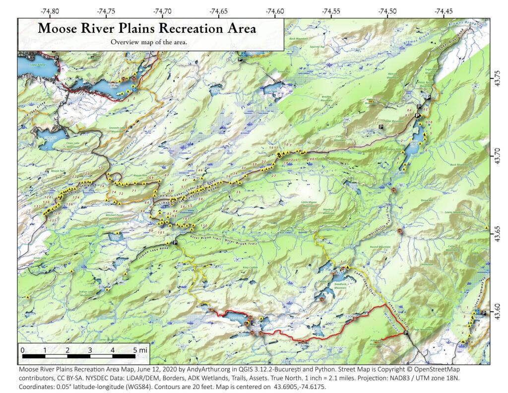
| Moose River Plains Wild Forest |
Loop Road |
1.2 |
| Moose River Plains Wild Forest |
Indian Lake Road |
3.4 |
| Moose River Plains Wild Forest |
Otter Brook Road |
3.4 |
| Moose River Plains Wild Forest |
Rock Dam Road |
4.2 |
| Moose River Plains Wild Forest |
Lime Kiln Lake – Cedar River Road |
16.9 |
| Morgan Hill State Forest |
Herlihy Haul Road |
0.6 |
| Morgan Hill State Forest |
Keith Gutchess Haul Road |
0.7 |
| Morrow Mountain State Forest |
Mollie Road |
2.8 |
| Mount Hunger State Forest |
Whalen Road |
0.6 |
| Mount Pisgah State Forest |
Mt Pisgah Access Road #1 |
1.3 |
| Mount Pleasant State Forest |
Beck Forest Road |
0.6 |
| Mount Pleasant State Forest |
Brumagin Forest Road |
0.7 |
| Mount Pleasant State Forest |
Spruce Forest Road |
0.8 |
| Mount Tom State Forest |
Notch Lane Access Road |
1.4 |
| Mount Tom State Forest |
Shaker Hollow Access Trail |
1.4 |
| Muller Hill State Forest |
Davenport Road |
1.4 |
| Muller Hill State Forest |
Bliss Road |
1.5 |
| New Forge State Forest |
New Forge Access Road #2 |
0.5 |
| New Forge State Forest |
New Forge Access Road #3 |
0.6 |
| New Forge State Forest |
New Forge Access Road |
1.5 |
| Newfield State Forest |
Irish Hill Haul Road |
0.8 |
| Nicks Lake Campground |
Nicks Lake Campground Roads |
0.6 |
| Nimham Mountain Multiple Use Area |
Coles Mills Road |
0.7 |
| Nimham Mountain Multiple Use Area |
Tower Road |
0.7 |
| Nine Mile Creek State Forest |
North Nine Mile Town Road |
0.5 |
| Nine Mile Creek State Forest |
Phearsdorf Forest Road |
0.5 |
| Nine Mile Creek State Forest |
North Nine Mile Forest Road |
2.2 |
| North Harmony State Forest |
Snake Forest Road |
0.9 |
| North South Lake Campground |
South Lake Road |
1.3 |
| North South Lake Campground |
North Lake Campground Road |
1.8 |
| Northhampton Beach Campground |
Campground Road |
5.5 |
| Oakley Corners State Forest |
Oakley Corners North Public Forest Acess Road |
1.6 |
| Ohissa State Forest |
Cramers Corner Road |
0.8 |
| Onjebonge State Forest |
Lime Quarry Road |
1.3 |
| Onjebonge State Forest |
Alice Coffey Road |
2.5 |
| Orebed Creek State Forest |
Ritz Road |
1.3 |
| Ossian State Forest |
Back Road To Rattlesnake |
0.7 |
| Ossian State Forest |
Scoville Access Road |
1 |
| Ossian State Forest |
Linzy Road Truck Trail |
1.8 |
| Otselic State Forest |
Truck Trail |
3.1 |
| Otsquago State Forest |
Wagner Hill Road |
0.8 |
| Otter Creek State Forest |
Eatonville Road |
0.6 |
| Otter Creek State Forest |
Mikes Road |
1.2 |
| Otter Creek State Forest |
Otter Creek Road |
1.5 |
| Palmer’s Pond State Forest |
Geitner Forest Road |
0.7 |
| Palmer’s Pond State Forest |
Palmer’s Pond Forest Road |
1.5 |
| Palmer’s Pond State Forest |
6 |
2.4 |
| Partridge Run Wma |
Boys Camp Road Ext |
2 |
| Patria State Forest |
Pleasant Valley Road |
0.6 |
| Patria State Forest |
Barkman Road Access |
0.6 |
| Patria State Forest |
Hardscrabble Road Access |
0.8 |
| Peck Hill State Forest |
Swamp Road |
0.5 |
| Peck Hill State Forest |
West Boundary Trail |
0.6 |
| Peck Hill State Forest |
Beaver Vly |
0.7 |
| Peck Hill State Forest |
Dam Road |
0.7 |
| Penn Mountain State Forest |
Star Hill Road |
1 |
| Penn Mountain State Forest |
West Gate Road |
2.6 |
| Penn Mountain State Forest |
South Gate Road |
3.6 |
| Penn Mountain State Forest |
East Gate Road |
3.8 |
| Perch River Wma |
Perch Lake Road |
0.5 |
| Perch River Wma |
Buckminster Road |
0.9 |
| Perch River Wma |
Cook Road |
1.4 |
| Perch River Wma |
Allen Road |
2.1 |
| Perch River Wma |
State Route 12 |
2.6 |
| Perch River Wma |
Vaadi Road |
3 |
| Perch River Wma |
Dog Hill Road |
4 |
| Pharsalia Woods State Forest |
Nine Mile Truck Trail Snowmobile Trail |
1.6 |
| Piermont Marsh Tidal Wetland |
Piermont Pier Access Road |
0.9 |
| Pine Hill State Forest |
Bundy Hollow Public Forest Access Road |
1 |
| Pittstown State Forest |
State Fire Lane |
2.2 |
| Plainfield State Forest |
Hughes Public Forest Access Road |
1.3 |
| Plattekill State Forest |
Mountain Brook Road |
1 |
| Plumbottom State Forest |
Reddy Forest Road |
3 |
| Point Peninsula Wma |
Pine Woods Road |
1.5 |
| Point Peninsula Wma |
Beach Road |
2.1 |
| Point Peninsula Wma |
Shore Road |
8 |
| Point Rock State Forest |
Egger Brrok Raod |
1.3 |
| Popple Pond State Forest |
Smith Road |
0.7 |
| Popple Pond State Forest |
Haul Road Shared By Oneida 6 And County Forest |
1.6 |
| Popple Pond State Forest |
Truck Trail |
3 |
| Potato Hill State Forest |
Blackman Hill Rd |
1.1 |
| Potato Hill State Forest |
Level Green Rd |
1.2 |
| Pulpit Rock State Forest |
Watson Road |
0.6 |
| Punkeyville State Forest |
Irish Settlement Road |
0.7 |
| Punkeyville State Forest |
River Road |
0.9 |
| R Milton Hick Memorial State Forest |
Lafleuer Road |
1.2 |
| Relay State Forest |
Relay Public Forest Access Road |
1.2 |
| Rensselaerville State Forest |
Kenyon Road Access |
2.4 |
| Ridge Conservation Area And Maintenance Center |
Mid-Island Access Road |
0.5 |
| Rock City State Forest |
Salamanca Forest Road |
0.8 |
| Rock City State Forest |
Eckert Forest Road |
0.9 |
| Rock City State Forest |
Little Rock City Forest Road |
2 |
| Rock Creek State Forest |
Admin Access Road |
1.3 |
| Rockwood State Forest |
Spring Road |
0.5 |
| Rockwood State Forest |
B Road |
0.6 |
| Rocky Point Pine Barrens State Forest |
Accessible |
0.5 |
| Rocky Point Pine Barrens State Forest |
Firestone Road |
1.7 |
| Rural Grove State Forest |
Rural Grove Access Road (Shibley Road) |
3.1 |
| Rush Creek State Forest |
C2-C |
1.2 |
| Rush Creek State Forest |
Russell Forest Road |
3 |
| Sacandaga Campground |
Sacandaga Campground |
1.4 |
| Salmon River State Forest |
Harpers Ferry Public Forest Acess Road |
0.9 |
| Sand Flats State Forest |
Bucks Corners Road |
0.9 |
| Sand Flats State Forest |
Obrian Road |
0.9 |
| Sand Flats State Forest |
Water Hole Road |
1 |
| Sand Flats State Forest |
Y Road |
1.5 |
| Sand Flats State Forest |
Powell Road |
1.7 |
| Sand Flats State Forest |
Fall Brook Road |
2.2 |
| Saranac Lakes Wild Forest |
Horseshoe Pond Trail |
0.5 |
| Saranac Lakes Wild Forest |
Little Clear Pond Road |
0.5 |
| Saranac Lakes Wild Forest |
Connery Pond Road |
0.6 |
| Saranac Lakes Wild Forest |
Little Green Pond Road |
0.6 |
| Saranac Lakes Wild Forest |
Rollins Pond Access Road |
0.8 |
| Saranac Lakes Wild Forest |
Medow Pond Truck Trail |
0.9 |
| Saranac Lakes Wild Forest |
Bartlett Carry Road |
1.2 |
| Saranac Lakes Wild Forest |
Floodwood Mountain Road |
1.2 |
| Saranac Lakes Wild Forest |
Rat Pond Road |
1.5 |
| Saranac Lakes Wild Forest |
Sunday Pond Road |
1.6 |
| Scott Patent State Forest |
Scott Patent Access Road |
1.4 |
| Shawangunk Ridge State Forest |
Woods Road |
1 |
| Shindagin Hollow State Forest |
Ekroos Public Forest Acess Road |
1.4 |
| Skyline Drive State Forest |
Skyline Drive Public Forest Acess Road |
2.2 |
| Slader Creek State Forest |
Oberdorf Forest Road |
2.1 |
| Sonyea State Forest |
Shaker Access Road |
1.9 |
| South Bradford State Forest |
Ccc Road |
1.6 |
| South Hill State Forest |
South Hill Truck Trail |
0.5 |
| South Hill State Forest |
Public Forest Access Road Extension |
0.9 |
| South Hill State Forest |
South Hill Public Forest Access Road |
0.9 |
| South Hill State Forest |
Kotary Road Extension |
1 |
| South Hill State Forest |
Powerline Road |
1 |
| South Mountain State Forest |
Ashland Pinnacle Access Road #2 |
0.5 |
| South Mountain State Forest |
South Mountain Access Road |
0.9 |
| South Mountain State Forest |
Bluebird Road |
1.1 |
| South Valley State Forest |
Phillips Brook Fr First Section |
0.7 |
| South Valley State Forest |
Phillips Brook Forest Road |
1.2 |
| St. Regis River State Forest |
Old Railroad Bed |
1.6 |
| Stammer Creek State Forest |
Sugar Bush Haul Road |
1.1 |
| Steam Mill State Forest |
Zion Public Forest Access Road #2 |
0.5 |
| Steam Mill State Forest |
Glass House Hill Road |
1 |
| Steam Mill State Forest |
Assembly Road |
1.1 |
| Steam Mill State Forest |
Steammill Rd |
1.4 |
| Steam Mill State Forest |
Carroll Hill Public Forest Access Road #2 |
1.9 |
| Steam Mill State Forest |
Zion Public Forest Access Road #1 |
2 |
| Steam Mill State Forest |
Carroll Hill Public Forest Access Road #3 |
2.5 |
| Stewart State Forest |
Great Swamp Road |
0.5 |
| Stewart State Forest |
Drakes Ln |
0.6 |
| Stewart State Forest |
Orlando Dr |
0.6 |
| Stewart State Forest |
Ridge Road South |
0.6 |
| Stewart State Forest |
Scofield Lane |
0.7 |
| Stewart State Forest |
Armstrong Lane Trail |
0.9 |
| Stewart State Forest |
Giles Road |
0.9 |
| Stewart State Forest |
Pittman Robertson Pond Road |
0.9 |
| Stewart State Forest |
Weed Road |
1.2 |
| Stewart State Forest |
Beaver Pond Road |
1.3 |
| Stewart State Forest |
Barron Road |
1.8 |
| Stewart State Forest |
Barron Road South 208 |
1.8 |
| Stewart State Forest |
Ridge Road |
2.8 |
| Stewart State Forest |
Maple Ave |
3.1 |
| Stewart State Forest |
New Road |
3.4 |
| Stockton State Forest |
Blackman Forest Road |
1.4 |
| Stone Store State Forest |
Fawn Ridge Road |
2.7 |
| Sugar Hill State Forest |
Firetower Access Road |
0.5 |
| Sugar Hill State Forest |
Old Westerfield Road |
0.5 |
| Sugar Hill State Forest |
A Trail |
1 |
| Sugar Hill State Forest |
Pine Knob Road |
1 |
| Sugar Hill State Forest |
Maple Lane |
2.1 |
| Summer Hill State Forest |
Snowmobile Trail |
5 |
| Sundown Wild Forest |
South Mountain Extension |
1 |
| Swancott Hill State Forest |
Tower Road |
2.3 |
| Swancott Mill State Forest |
Swancott Mill Road |
0.9 |
| Taconic Hereford Multiple Use Area |
Pirate Crrek |
0.5 |
| Taconic Hereford Multiple Use Area |
Whatchamacallit |
0.5 |
| Taconic Hereford Multiple Use Area |
Camp |
0.6 |
| Taconic Hereford Multiple Use Area |
Mercury |
0.6 |
| Taconic Hereford Multiple Use Area |
Border Trail |
0.8 |
| Taconic Hereford Multiple Use Area |
Mustang |
0.8 |
| Taconic Hereford Multiple Use Area |
Outer Gut |
0.8 |
| Taconic Hereford Multiple Use Area |
Brockway Road |
0.9 |
| Taconic Hereford Multiple Use Area |
Green Acres |
1.2 |
| Taconic Hereford Multiple Use Area |
Tsp Road |
1.2 |
| Taconic Hereford Multiple Use Area |
Pond Gut Road |
1.3 |
| Taconic Hereford Multiple Use Area |
Timbuktu |
1.3 |
| Taconic Hereford Multiple Use Area |
Fong’s Way |
1.4 |
| Taconic Hereford Multiple Use Area |
Getaway |
1.9 |
| Taconic Hereford Multiple Use Area |
Upper Snowmobile Trail |
1.9 |
| Taconic Ridge State Forest |
Rounds Mountain Rd. |
0.8 |
| Taconic Ridge State Forest |
Robinson’s Hollow Road |
0.9 |
| Taconic Ridge State Forest |
Green Hollow Access Road |
1.1 |
| Taylor Creek State Forest |
T Road Public Forest Access Road |
1 |
| Taylor Valley State Forest |
Seacord Hill Spur Public Forest Acess Road |
0.9 |
| Taylor Valley State Forest |
Seacord Hill Public Forest Acess Road |
2.1 |
| Taylor Valley State Forest |
Mount Roderick Public Forest Acess Road |
4.3 |
| Terry Mountain State Forest |
Lynch Mt Road Trail |
1 |
| Terry Mountain State Forest |
Red Road |
1.7 |
| Terry Mountain State Forest |
Mud Pond Road Trail |
2 |
| Terry Mountain State Forest |
Tower Road |
2 |
| Texas Hill State Forest |
M8 Access Trail |
0.6 |
| Texas Hill State Forest |
Texas Hill Truck Trail |
0.7 |
| Texas School House State Forest |
New Lisbon Public Forest Access Road |
1.2 |
| Three Springs State Forest |
Three Springs Access Road |
1.6 |
| Tied Lake Primitive Area |
Tied Lake Road |
1.2 |
| Titusville Mountain State Forest |
Lee Road |
2 |
| Tomannex State Forest |
Tomannex Public Forest Access Road |
1 |
| Tomannex State Forest |
Haul Road #1 |
4.7 |
| Toothaker Creek State Forest |
Garrison Access Trail |
1.1 |
| Tri-County State Forest |
Flanagan Road |
0.5 |
| Trout Lake State Forest |
Cedar Lake Public Forest Access Road |
0.5 |
| Tug Hill State Forest |
Home Run Road |
0.6 |
| Tug Hill State Forest |
Babbit Road |
0.8 |
| Tug Hill State Forest |
Gruntley Road |
1.3 |
| Tug Hill State Forest |
Mile Strip Road |
2.5 |
| Tug Hill State Forest |
Denning (West) Road |
2.8 |
| Tug Hill State Forest |
Willams Road |
2.9 |
| Tug Hill State Forest |
Horace Forward Road |
3.3 |
| Tug Hill Wma |
Alphabet Lane Road |
0.8 |
| Tug Hill Wma |
Runing George Road |
1.3 |
| Tug Hill Wma |
Beech Street Road |
1.7 |
| Tug Hill Wma |
Running George Road |
3.8 |
| Tuller Hill State Forest |
Snyder Hill Public Forest Acess Road |
1.6 |
| Tuller Hill State Forest |
Pipeline Public Forest Acess Road |
1.6 |
| Tuller Hill State Forest |
Vinnedge Public Forest Acess Road |
1.7 |
| Turkey Hill State Forest |
Turkey Hill Public Forest Acess Road |
1.3 |
| Turkey Ridge State Forest |
Turkey Road |
0.7 |
| Turnpike State Forest |
Turnpike Forest Road |
2.2 |
| Turnpike State Forest |
Stewart Forest Road |
3.1 |
| Upper And Lower Lakes Wma |
Canton Access Road |
0.5 |
| Upper And Lower Lakes Wma |
Logging Access Road |
0.5 |
| Upper And Lower Lakes Wma |
Corning Access Road |
1 |
| Upper And Lower Lakes Wma |
Middle Access Road |
1.2 |
| Vandermark State Forest |
Allen Forest Road |
1.1 |
| Vandermark State Forest |
Bird Forest Road |
1.5 |
| Vanderwhacker Mountain Wild Forest |
Cheney Pond Road |
0.5 |
| Vanderwhacker Mountain Wild Forest |
Thilo Road |
1.7 |
| Vanderwhacker Mountain Wild Forest |
Vanderwhacker Road |
2.6 |
| Watson’s East Triangle Wild Forest |
Wolf Creek Road West |
0.5 |
| Watson’s East Triangle Wild Forest |
Deep Cuts Road |
0.6 |
| Watson’s East Triangle Wild Forest |
Tunnel Road |
0.7 |
| Watson’s East Triangle Wild Forest |
Number 1 Road |
2.1 |
| Watson’s East Triangle Wild Forest |
Bear Pond Road |
8.4 |
| Webster Hill State Forest |
Webster Hill Forest Access Road |
0.8 |
| West Canada Lake Wilderness |
Northville-Placid Trail |
2.2 |
| West Parishville State Forest |
Scotch Pine Access Trail |
0.5 |
| West Parishville State Forest |
Red Pine Access Trail |
0.7 |
| West Parishville State Forest |
Kidney Killer Access Trail |
0.9 |
| Whalen Memorial State Forest |
Whalen Forest Road |
1.6 |
| Whaupaunaucau State Forest |
Haul Road #4 |
0.5 |
| Whaupaunaucau State Forest |
Alguire Road |
1 |
| Whaupaunaucau State Forest |
C8 – B15 Road |
1.3 |
| Whippoorwill Corners State Forest |
Loop Access Road |
1.3 |
| Whiskey Flats State Forest |
Capell Access Road |
0.5 |
| Whiskey Flats State Forest |
Sochia Pond Public Forest Access Road |
0.5 |
| Whiskey Flats State Forest |
Sandy Public Forest Access Road |
0.7 |
| White Pond Multiple Use Area |
Farmers Mills Road |
0.9 |
| White Pond Multiple Use Area |
White Pond Road |
1 |
| Wilcox Lake Wild Forest |
Dorr Road |
0.5 |
| Wilcox Lake Wild Forest |
Lizard Pond Road |
0.6 |
| Wilcox Lake Wild Forest |
Mud Pond Road |
0.7 |
| Wilcox Lake Wild Forest |
Fish Ponds Road |
0.8 |
| Wilcox Lake Wild Forest |
Harrisburg Lake Road |
1.5 |
| Wilcox Lake Wild Forest |
Pumpkin Hollow Road |
1.5 |
| Wilcox Lake Wild Forest |
Oregon Road |
1.7 |
| Wilcox Lake Wild Forest |
West Stony Creek Road |
5.4 |
| Wiley Brook State Forest |
Finger Lakes Trail |
0.7 |
| William C. Whitney Wilderness |
Lake Lila Road |
5.8 |
| Wilson Hill Wma |
Sand Road |
0.6 |
| Wilson Hill Wma |
Northern Access Road |
1.9 |
| Winona State Forest |
Blood Road |
0.7 |
| Winona State Forest |
Hessel Road |
0.9 |
| Winona State Forest |
Remington |
1.1 |
| Winona State Forest |
Hawley Road |
1.5 |
| Winona State Forest |
Tucker Road |
2.6 |
| Winona State Forest |
Bargy (Main) Road |
3.2 |
| Wolf Lake State Forest |
Orbegezo Row |
1.4 |
| Woodland Valley Campground |
Woodland Valley Road |
0.5 |
| Woodland Valley Campground |
Camping Trail Road |
0.8 |
| Yatesville Falls State Forest |
Yatesville Falls Access Road |
1.2 |