Counties: Albany to Delaware / Dutchess to Livingston / Madison to Otsego / Putnam to Suffolk / Sullivan to Yates
Browse Topographic Maps: Full State / Historical USGS Topographic Maps
Counties: Albany to Delaware / Dutchess to Livingston / Madison to Otsego / Putnam to Suffolk / Sullivan to Yates
Browse Topographic Maps: Full State / Historical USGS Topographic Maps
Counties: Albany to Delaware / Dutchess to Livingston / Madison to Otsego / Putnam to Suffolk / Sullivan to Yates
Browse Topographic Maps: Full State / Historical USGS Topographic Maps
Below is a listing of DEC parking areas in the Catskill Park with coordinates and addresses, nearby trails and the roads they are located on.
| Trail | Road | Name | Notes | Street | City | St | ZIP | Latitude | Longitude |
| Ashokan High Point | Watson Hollow Road | Kanape Valley Parking Lot | 826 Watson Hollow Rd | West Shokan | NY | 12494 | 41.9357923141228 | -74.3281141901214 | |
| Beaverkill Road | Beaverkill Road | Beaverkill Road Parking Lot | 2795 Beaverkill Rd | Livingston Manor | NY | 12758 | 42.0117166110155 | -74.6223767934834 | |
| Beaverkill Road | Turnwood Road | Beaverkill Road Parking Lot | 2952 Beaverkill Rd | Livingston Manor | NY | 12758 | 42.0233290355646 | -74.5995306115641 | |
| Becker Hollow Trail | Lane Road | Becker Hollow Parking Lot | 6 Vehicle Capacity | 3940 Route 214 | Elka Park | NY | 12427 | 42.1816084527769 | -74.1969812784753 |
| Bengle Hill Trail | Peekamoose Road | Eastern Upper Field Parking Lot | 359 Peekamoose Rd | Grahamsville | NY | 12740 | 41.9166423616552 | -74.4377863112221 | |
| Bengle Hill Trail | Peekamoose Road | Lower Field Parking Lot | 194 Peekamoose Rd | Grahamsville | NY | 12740 | 41.9101942400042 | -74.452852499381 | |
| Bengle Hill Trail | Peekamoose Road | Middle Field Parking Lot | 304 Peekamoose Rd | Grahamsville | NY | 12740 | 41.9158997405029 | -74.443422031256 | |
| Bengle Hill Trail | Peekamoose Road | North Middle Field Parking Lot | 304 Peekamoose Rd | Grahamsville | NY | 12740 | 41.9164180048779 | -74.4416441135141 | |
| Bengle Hill Trail | Peekamoose Road | Trailer Feild Parking Lot | 359 Peekamoose Rd | Grahamsville | NY | 12740 | 41.9162603251141 | -74.4346555497984 | |
| Bengle Hill Trail | Peekamoose Road | Western Upper Field | 359 Peekamoose Rd | Grahamsville | NY | 12740 | 41.9169982073948 | -74.4396463051141 | |
| Big Pond – Alder Lake | Barkaboom Road | Barkaboom Road Parking Lot | Located On Barkaboom Road, 6 Cars | 288 Barkaboom Rd | Andes | NY | 13731 | 42.0426860004001 | -74.7267519998891 |
| Big Pond – Alder Lake | Cross Mountain Road | Alder Lake Parking Lot | 2 Cross Mountain Rd | Livingston Manor | NY | 12758 | 42.0497953211373 | -74.6827571604492 | |
| Black Dome Trail | Big Hollow Road | Big Hollow Road Parking Lot | 7 Vehicle Capacity | 947 Route 56 | Maplecrest | NY | 12454 | 42.2889033425096 | -74.1151262941519 |
| Campbell Mountain Trail | Cat Hollow Road | Route 206 Parking Lot | 5 Vehicle Capacity | 1611 County Road 7 | Roscoe | NY | 12776 | 42.051659649187 | -74.9147231839428 |
| Cic – Esopus Trail | State Route 28 | Parking Area For Esopus Creek Fishing Access | Parking Area For Esopus Creek Fishing Access – Cic | 5067 Route 28 | Mount Tremper | NY | 12457 | 42.0254799892217 | -74.2717292519349 |
| Cic Hill Trail | Wittenberg Road | Wittenberg Road Parking Lot | 1298 Wittenberg Rd | Mount Tremper | NY | 12457 | 42.0279684988885 | -74.2620571929729 | |
| Colgate Lake Trail To Dutcher Notch | Colgate Road | Colgate Lake Lower Parking Lot | 50 Vehicle Capacity | 525 Colgate Rd | East Jewett | NY | 12424 | 42.2384696568264 | -74.1233979344461 |
| Colgate Lake Trail To Dutcher Notch | Colgate Road | Colgate Lake Parking Lot | 2 Vehicle Capacity | 524 Colgate Rd | East Jewett | NY | 12424 | 42.2385040003097 | -74.1206960003026 |
| Colgate Lake Trail To Dutcher Notch | Colgate Road | Colgate Lake Trail Parking Lot | 8 Vehicle Capacity | 653 Colgate Rd | East Jewett | NY | 12424 | 42.2384599994304 | -74.1163269993959 |
| Condon Hollow Rd. | Condon Hollow Road | Condon Hollow Road Parking Lot | 3 Vehicle Capacity | 139 Condon Hollow Rd | West Kill | NY | 12492 | 42.2161010059593 | -74.4163349850283 |
| Condon Hollow Rd. | Elk Creek Road | Elk Creek Road Parking Lot | 5 Vehicle Capacity | 734 Elk Creek Rd | Fleischmanns | NY | 12430 | 42.1996047835286 | -74.4451315908425 |
| Condon Hollow Rd. | South Beech Ridge Road | Beech Road Parking Lot | 4 Vehicle Capacity | 291 S Beech Ridge Rd | West Kill | NY | 12492 | 42.2139020709257 | -74.4012095700882 |
| Condon Hollow Rd. | State Highway 42 | Rte 42 Parking Lot | 3 Vehicle Capacity | 1088 Route 42 | Shandaken | NY | 12480 | 42.1851525975488 | -74.4149115068685 |
| Denman Mountain Snowmobile Trail | Glade Hill Road | Denman Parking Lot | 327 Glade Hill Rd | Grahamsville | NY | 12740 | 41.8853341886314 | -74.5320280123605 | |
| Denman Mountain Snowmobile Trail | Moore Hill Road | Hogs Roack Plot Parking Lot | 578 Alpha Rd | Grahamsville | NY | 12740 | 41.9003387815796 | -74.5274487605523 | |
| Devil’s Path | Broadstreet Hollow Road | Broadstreer Hollow Parking Lot | 2 Vehicle Capacity | 619 Broadstreet Hollow Rd | Shandaken | NY | 12480 | 42.1394450770105 | -74.3308357356817 |
| Devil’s Path | Spruceton Road | Spruceton Road Parking Lot | 5 Vehicle Capacity | 1518 Spruceton Rd | West Kill | NY | 12492 | 42.1920191641918 | -74.3238474073796 |
| Devil’s Path | Prediger Road | Prediger Road | 75 Prediger Rd | Elka Park | NY | 12427 | 42.1338909995054 | -74.1042720006852 | |
| Diamond Notch Trail | Diamond Notch Road | South Diamond Notch Parking Lot | 2 Vehicle Capacity | 508 Diamond Notch Rd | West Kill | NY | 12492 | 42.147861770123 | -74.2646596008456 |
| Diamond Notch Trail | Spruceton Road | Diamond Notch Parking Lot | 8 Vehicle Capacity | 2778 Spruceton Rd | West Kill | NY | 12492 | 42.1823740001994 | -74.2695430002389 |
| Dry Brook Ridge Trail | Mill Brook Road | Dry Brook Ridge Parking Lot | 12 Balsam Mountain Camp Rd | Margaretville | NY | 12455 | 42.0715022570921 | -74.5738756337513 | |
| Dry Brook Ridge Trail | South Side Spur | North End Of Dry Brook Ridge Parking Lot | 301 Southside Spur | Margaretville | NY | 12455 | 42.1446292458628 | -74.649333317932 | |
| Elm Ridge Trail | Peck Road | Peck Road Parking Lot | 10 Vehicle Capacity | 189 Peck Rd | Maplecrest | NY | 12454 | 42.2965789997488 | -74.1693680002929 |
| Fluggertown Road Long Pond Trail | Fluggertown Road | Flugertown Road Parking Lot | 191 Flugertown Rd | Livingston Manor | NY | 12758 | 41.9347657909639 | -74.649696950272 | |
| Flynn Trail | Mongaup Road | Mongaup Road Parking Lot | 1 Beech Mountain Rd | Livingston Manor | NY | 12758 | 41.9467974587868 | -74.7052771774711 | |
| Giant Ledge-Panther Mountian-Fox Hollow Trail | Fox Hollow Road | Fox Hollow Road Parking Lot | 67 Mountain Dr | Shandaken | NY | 12480 | 42.1008382907335 | -74.3904559601097 | |
| Giant Ledge-Panther Mountian-Fox Hollow Trail | Peck Hollow Road | Peck Hollow Road Parking Lot | 254 Peck Hollow Rd | Shandaken | NY | 12480 | 42.1357649784827 | -74.3712920364471 | |
| Giant Ledge-Panther Mountian-Fox Hollow Trail | Peck Hollow Road | Esopus Creek Fishing Access (Upper) | Gravel | 7019 Route 28 | Pheonicia | NY | 12464 | 42.1065553340012 | -74.3519924442835 |
| Giggle Hollow Trail | NY 23 – Belleayr | Belleayre Day Use Parking Lot | 33 Friendship Manor Rd | Pine Hill | NY | 12465 | 42.1256810090987 | -74.4731178408634 | |
| Harding Road Spur Trail | Whites Road | Whites Road Parking Lot | 4 Vehicle Capacity | 274 White Rd | Palenville | NY | 12463 | 42.1823951680298 | -74.0261906353256 |
| Harding Road Trail | Harding Road | Harding Road Parking Lot | 5 Vehicle Capacity | 3525 Route 23A | Palenville | NY | 12463 | 42.1762358120255 | -74.0304949714876 |
| Huckleberry North Trail | Hill Road | Hill Road Parking Lot | 4 Vehicle Capacity | 1209 Hill Rd | Margaretville | NY | 12455 | 42.1166129796449 | -74.6486105632054 |
| Huckleberry North Trail | Huckleberry Brook Spur Road | Huckleberry Brook Road Parking Lot | 6 Vehicle Capacity | 1613 Huckleberry Brook Rd | Margaretville | NY | 12455 | 42.1130238724914 | -74.6515523618233 |
| Huckleberry South Trail | Huckleberry Brook Spur Road | Huckleberry Road Parking Lot | 5 Vehicle Capacity | 1073 Huckleberry Brook Rd | Margaretville | NY | 12455 | 42.1152546105706 | -74.6636037740616 |
| Huckleberry South Trail | Hull Road | Ploutz Road | 4 Vehicle Capacity | 1634 Ploutz Rd | Margaretville | NY | 12455 | 42.0938719675255 | -74.6204457323272 |
| Huggins Lake Trail | Berry Brook Road | Huggins Lake Road Parking Lot | 4 Vehicle Capacity | 2414 Holiday And Berry Brook Rd | Roscoe | NY | 12776 | 42.0157959909969 | -74.8436914198853 |
| Jockey Hill Bicycle Trail | Wood Road | Wood Road Parking Lot | 334 Woods Rd | Kingston | NY | 12401 | 41.9777439980953 | -74.0501113306995 | |
| Kaaterskill Falls Trail | State Highway 23a | Molly Smith Parking Lot | Dot Facility, 20 Vehicles | 4729 Route 23A | Elka Park | NY | 12427 | 42.1898508772368 | -74.074111945438 |
| Kaaterskill Rail Trail | Laurel House Rd | Laurel House Rd | 103 Laurel House Rd | Tannersville | NY | 12485 | 42.1956250050266 | -74.063093393786 | |
| Kelly Hollow Long Loop Trail | Mill Brook Road | East Kelly Hollow Parking Lot | 5163 Mill Brook Rd | Margaretville | NY | 12455 | 42.078800277463 | -74.6497556922038 | |
| Kelly Hollow Long Loop Trail | Mill Brook Road | West Kelly Hollow Parking Lot | 5163 Mill Brook Rd | Margaretville | NY | 12455 | 42.0795848697519 | -74.6545040693769 | |
| Long Path | Steenburg Road | Steenburgh Road | 2425 Platte Clove Rd | Elka Park | NY | 12427 | 42.1337889994516 | -74.0819709994867 | |
| Long Path | Route 23 | Route 23 Parking Lot | 20 Vehicle Capacity | 3 Cross Rd | Windham | NY | 12496 | 42.312706999584 | -74.1904309994766 |
| Long Pond South Loop | Willowemock Road | Wild Meadow Road Parking Lot | 136 Round Pond Rd | Claryville | NY | 12725 | 41.9435338737706 | -74.5864488816452 | |
| Lost Clove Trail | Lost Clove Road | Lost Clove Parking Lot | 343 Lost Clove Rd | Big Indian | NY | 12410 | 42.1054379266455 | -74.4700849794812 | |
| Mary Smith Trail | Holliday Brook Road | Holiday And Berry Brook Road Parking Lot | 5 Vehicle Capacity | 3851 Holiday And Berry Brook Rd | Roscoe | NY | 12776 | 42.0386999995498 | -74.8473909994493 |
| Mckinley Hollow Trail | Mc Kinley Hollow Road | Mckinly Hollow Parking Lot | 200 McKinley Hollow Rd | Big Indian | NY | 12410 | 42.0704132895809 | -74.4740296153462 | |
| Mckinley Hollow Trail | Rider Hollow Road | Rider Hollow Parking Lot | 12 Warren Todd Subdivision Dr | Arkville | NY | 12406 | 42.1018368545182 | -74.5170339246663 | |
| Mckinley Hollow Trail | Burnham Hollow Road | Burnham Hollow Parking Lot | 17 Sagmore Trl | Big Indian | NY | 12410 | 42.05564157218 | -74.4669789486585 | |
| Middle Mountain Trail | Mary Smith Hill Road | Mary Smith Hill Road Parking Lot | 3 Vehicle Capacity | 865 Mary Smith Hill Rd | Andes | NY | 13731 | 42.0401290003224 | -74.8089319993063 |
| Mink Hollow Trail | Mink Hollow Road | Lake Hill | 599 Mink Hollow Rd | Bearsville | NY | 12448 | 42.1051314008054 | -74.1735651990356 | |
| Mount Pleasant-Romer Mountain | State Highway 28 | Sawmill Lot | 50×50 Parking Area – Trailless | 6331 Route 28 | Phoenicia | NY | 12464 | 42.1008585056075 | -74.3445327399439 |
| Mud Pond Trail | County Road 179a | Old Rte 17 Fishing Access | 6 Vehicle Capacity | 6175 State Route 17 W | Roscoe | NY | 12776 | 41.9497668355721 | -74.9281906252666 |
| Mud Pond Trail | Horton Brook Road | Little Fuller Brook Parking Lot | 6 Vehicle Capacity | 845 Horton Brook Rd | Roscoe | NY | 12776 | 42.0159481159029 | -74.9790550095988 |
| Onteora Lake Parking Access | State Highway 28 | Onteora Lake Trailhead Upper Lot | 881 Route 28 | Kingston | NY | 12401 | 41.9807660434687 | -74.0853059041223 | |
| Onteora Lake Yellow Tral | NY 23 | Onteora Lake Parking | 960 Route 28 | Kingston | NY | 12401 | 41.9840941553893 | -74.0827910535657 | |
| Overlook Spur Trail Extension | Macdaniiel Road | Meads Meadow Parking Area | 452 MacDaniel Rd | Bearsville | NY | 12409 | 42.0756312690235 | -74.1276188121255 | |
| Overlook Trail | Meads Mountain Road | Overlook Mountain Trailhead | 334 Meads Mountain Rd | Woodstock | NY | 12498 | 42.0710794980857 | -74.1224765106456 | |
| Peekamoose-Table Trail | Peekamoose Road | Peekamoose Road Parking Lot | 415 Peekamoose Rd | Grahamsville | NY | 12740 | 41.9233895882109 | -74.4128616227944 | |
| Peekamoose-Table Trail | Peekamoose Road | Peekamose Mountian Trail Head Parking Lot | 415 Peekamoose Rd | Grahamsville | NY | 12740 | 41.9149365156904 | -74.4289858455429 | |
| Pelnor Hollow Trail | Beaver Kill Road | Waneta Lake Parking Lot | 732 Beaverkill Rd | Livingston Manor | NY | 12758 | 41.9676202925977 | -74.8292314401778 | |
| Phoenicia East Branch Trail | Denning Road | Denning Road Parking Lot | 3381 Denning Rd | Claryville | NY | 12725 | 41.9690314347788 | -74.4486958819482 | |
| Phoenicia East Branch Trail | Oliverea-Slide Mountain Road | Oliverea Road North Parking Lot | 1453 Oliverea Rd | Big Indian | NY | 12410 | 42.0265659167754 | -74.4038665935078 | |
| Phoenicia East Branch Trail | Oliverea-Slide Mountain Road | Oliverea Road South Parking Lot | 19 Shandaken Rod Gun Clb | Big Indian | NY | 12410 | 42.0078280894865 | -74.4268762683237 | |
| Phoenicia Trail | Plank Road | Tremper Mountain Parking Area | Gravel Lot | 5636 Route 28 | Phoenicia | NY | 12464 | 42.0705625579484 | -74.3024012416267 |
| Pine Hill West Branch Trail | West Branch Road | Biscuit Brook Parking Lot | 1886 Frost Valley Rd | Claryville | NY | 12725 | 41.990833872737 | -74.4845571593918 | |
| Powerline | Beech Ridge Road 1 | Vinegar Hill Parking Area | 1060 N Beech Ridge Rd | Prattsville | NY | 12468 | 42.2449000123037 | -74.4075985539776 | |
| Red Hill Fire Tower Trail | Red Hill Road | Red Hill Fire Tower Parking Lot | 129 Coons Rd | Claryville | NY | 12725 | 41.9302938486155 | -74.5073498606472 | |
| Roaring Kill Trail | Dale Lane | Roaring Kill | 6 Vehicle Capacity | 155 Roaring Kill Rd | Elka Park | NY | 12427 | 42.1511360000949 | -74.1310779997324 |
| Rochester Hollow | Shaft Road | Shaft 6 Parking | 20 Vehicle Capacity | 73 Shaft Rd | Shandaken | NY | 12480 | 42.166173156258 | -74.4083342114093 |
| Rochester Hollow | Spisak Way | Rochester Hollow Parking Lot | 51 Matyas Rd | Big Indian | NY | 12410 | 42.1179698674129 | -74.4517651458059 | |
| Seager Big Indian Trail | Dry Brook Road | Seager Parking Lot | 5672 Dry Brook Rd | Arkville | NY | 12406 | 42.0578836653667 | -74.5396998623234 | |
| Spencer Road | Trails End Road | Trails End Parking Lot | 197 Trails End Rd | Kerhonkson | NY | 12446 | 41.8835868385135 | -74.3594081701432 | |
| Spruceton Trail | Spruceton Road | Spruceton Trail Parking Lot | 20 Vehicle Capacity | 2628 Spruceton Rd | West Kill | NY | 12492 | 42.1846329998217 | -74.2719879999707 |
| Touch-Me-Not-Trail | Barkaboom Road | Big Pond Parking Lot | Located Off Barkaboom Road, 6 Cars | 366 Barkaboom Rd | Andes | NY | 13731 | 42.0433679998314 | -74.7277000006876 |
| Touch-Me-Not-Trail | Beech Hill Road | Beech Hill Road Parking Lot | 3 Vehicle Capacity | 2054 Beech Hill Rd | Andes | NY | 13731 | 42.0506230001697 | -74.7789470006467 |
| Touch-Me-Not-Trail | Deerlick Brook Road | Deerlick Road Parking Lot | 3 Vehicle Capacity | 1553 Deerlick Brook Rd | Andes | NY | 13731 | 42.0814567992576 | -74.7365160981546 |
| Touch-Me-Not-Trail | Barkaboom Road | Forest Preserve Access Parking | East Of Barkaboom Road 3 Cars | 1954 Barkaboom Rd | Andes | NY | 13731 | 42.0655363440977 | -74.7284401046935 |
| Trout Pond Access Route | Russell Brook Road | Russell Brook Road Parking Lot | 10 Vehicle Capacity | 4348 Russell Brook Rd | Roscoe | NY | 12776 | 41.9943949997582 | -74.941432999876 |
| Trout Pond Trail | Campbell Brook Road | Campbell Brook Road Parking Lot | 4747 Campbell Brook Rd | Downsville | NY | 13755 | 42.0306374772623 | -74.9384473452279 | |
| Trout Pond Trail | Campbell Mountain Road | Campbell Mountain Road Parking Lot | 5 Vehicle Capacity | 3693 Campbell Mountain Rd | Downsville | NY | 13755 | 42.0433291750688 | -74.9358959381363 |
| Vernooy Kill Falls Snowmobile Trail | Dymond Road | Dymond Road Parking Lot | 498 Yeagerville Rd | Napanoch | NY | 12458 | 41.8792625226568 | -74.4012606035291 | |
| Vernooy Kill Falls Snowmobile Trail | Upper Cherrytown Road | Upper Cherry Town Road Trail Head Parking Lot | 559 Upper Cherrytown Rd | Kerhonkson | NY | 12446 | 41.8643822024537 | -74.3454535201223 | |
| Willow Trail | Abbey Road | Mount Toblas Parking Lot | 439 Abbey Rd | Mount Tremper | NY | 12457 | 42.0537752508176 | -74.2306894602594 | |
| Willow Trail | Jessup Road | Willow Trailhead Parking | 6 Vehicle Capacity | 218 Jessop Rd | Willow | NY | 12495 | 42.078213053797 | -74.2442314353898 |

I am an amateur cartographer who designs maps and does a wide variety geospatial analysis using free and open-source geographic information software (GIS) and public sources of data to design quality maps, graphs, charts and datasets. I am looking for new and interesting projects to improve my skills, make connections and expand my portfolio.
Example maps can found below.
Example data can found below.
For most projects, there is no fee. I am looking for experience, references, mentors and connections in the geospatial community.
If you have a large project, let’s talk about it. I might be willing to do it for free, if it’s something really interesting
or important like fighting suburban sprawl and pollution. I don’t a business or taxes set up, so I can’t really charge at this point.
Please send me an email describing the mapping or data project in as much detail as possible.
My email is andy@andyarthur.org
Not currently. I can send you a file based on your specifications to print at your local print shop.
Depends on complexity of the project. Many projects only take minutes, however if a project requires georeferencing, data cleaning, or custom shapes or layouts, it might take significantly longer. More revisions lead to better quality output.
No! This is just a hobby. But I’m interested in expanding my skills. I do a lot of mapping for my blog and in support of community organizations like Save the Pine Bush.
Thats for you to decide. I don’t have formal education in map making, and I don’t have professional tools. But do take a look at the work I’ve done below.
This shows a 3D rendering of the Buckville Canal north of Hamilton
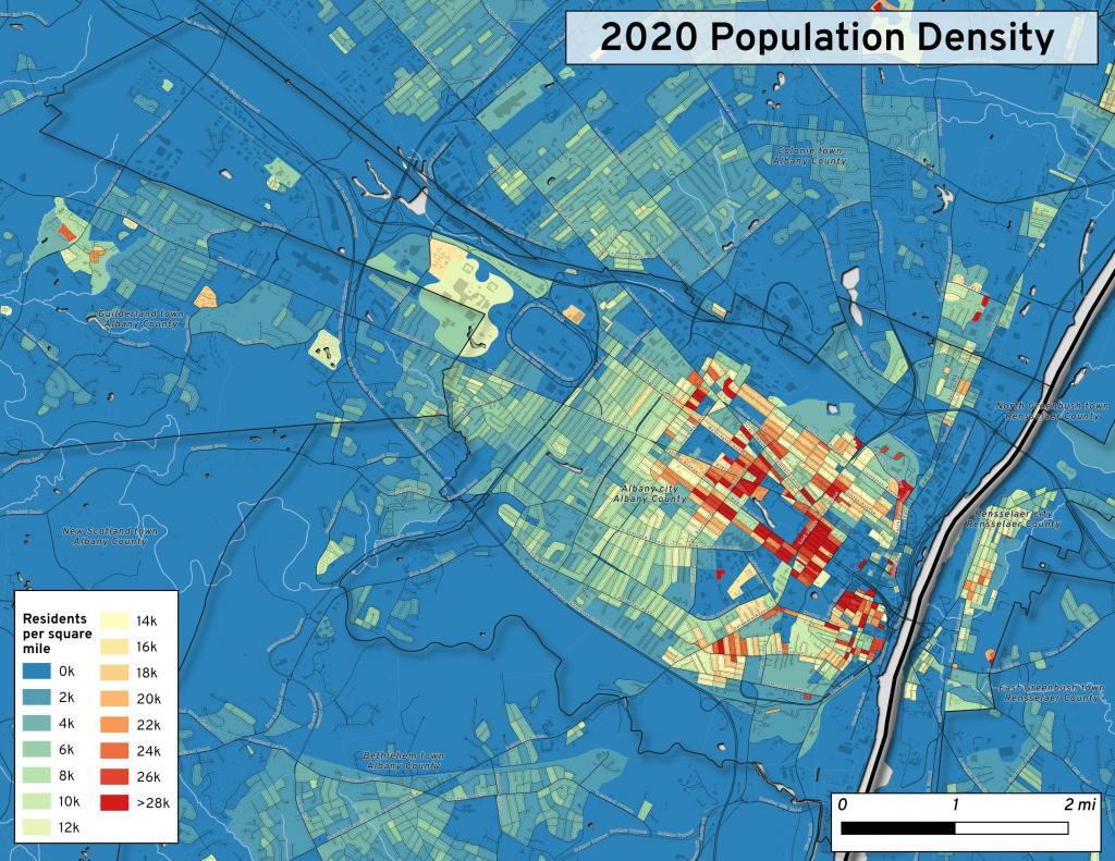
This map shows the use of 2020 PL 94-171 data to calculate population density in City of Albany.
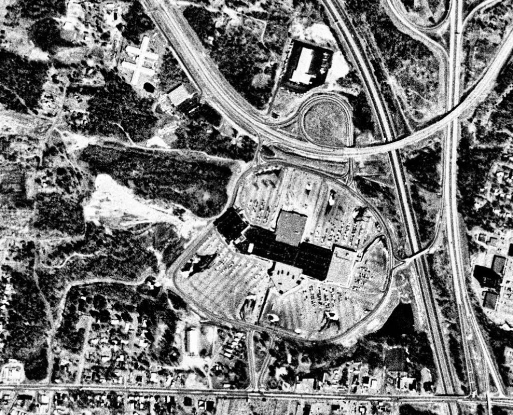
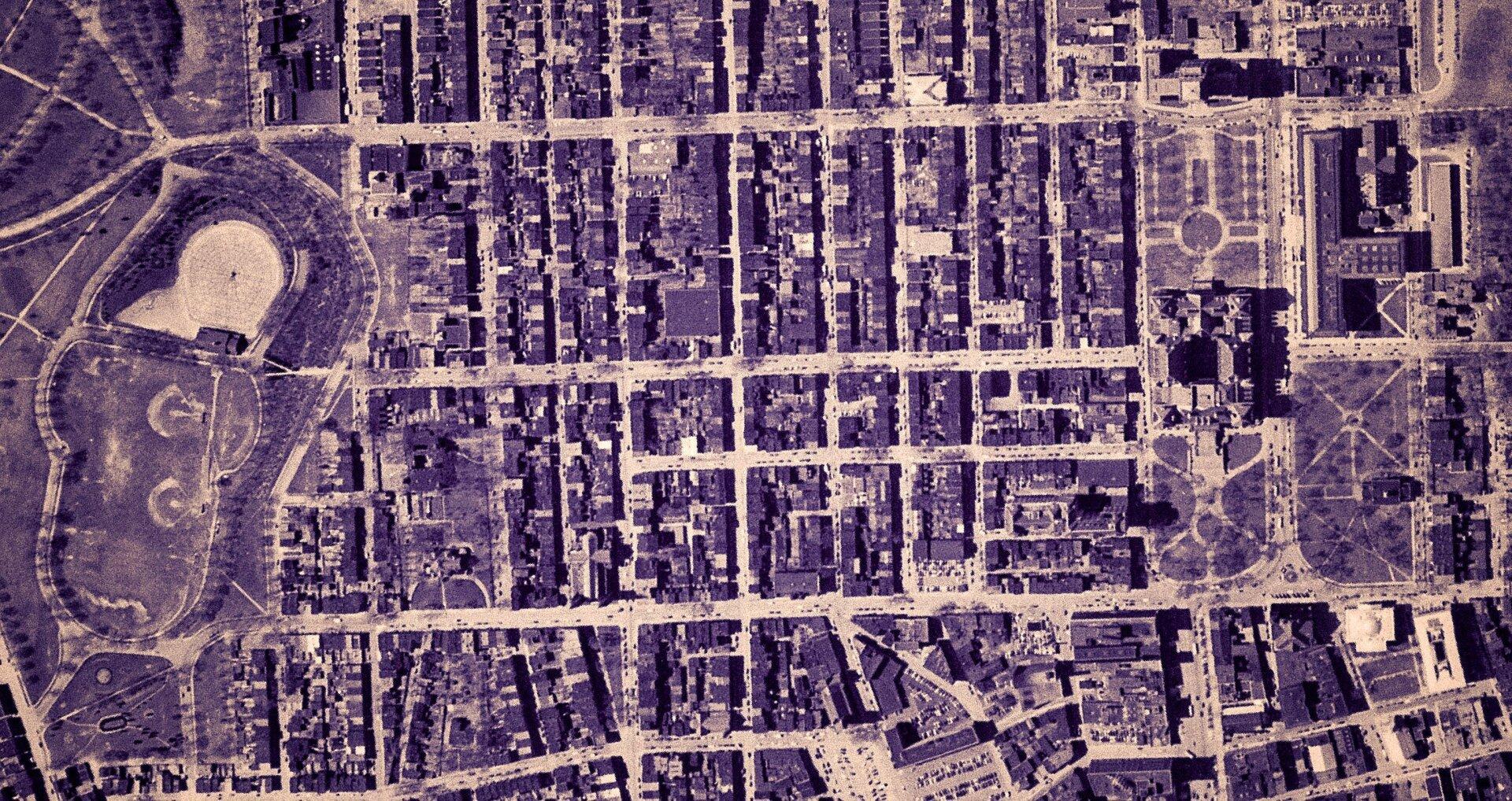
This 1985 aerial photo shows Crossgates Mall prior to it’s expansion.

This GIF image shows the change in unemployment during Coronavirus panademic.
This image shows hiking trails near Brooktrout, Falls Pond and Deep Lake.
Peebles Island, a Comparison 1952
3D Interactive of campsites at Moose River Plains.

Sample tax map in Albany.

Election results – 2020 Presidential Election, Onondoga County.

Map showing where sparklers are legally sold in New York.
Downtown Plattsburgh 1866 Beers (1866 Beers vs. 2020 OSM)
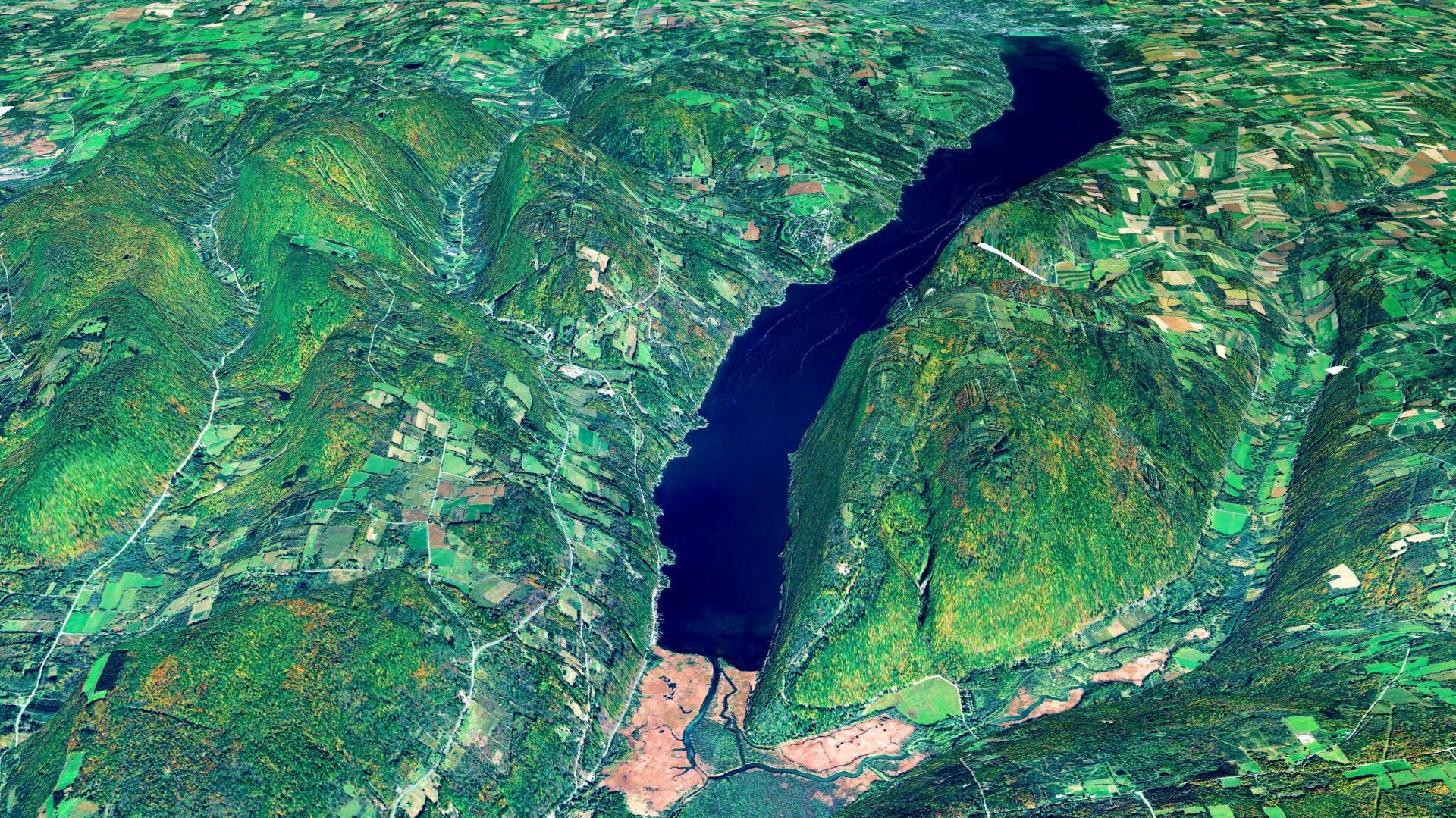
3D Rendering of Canandaigua Lake
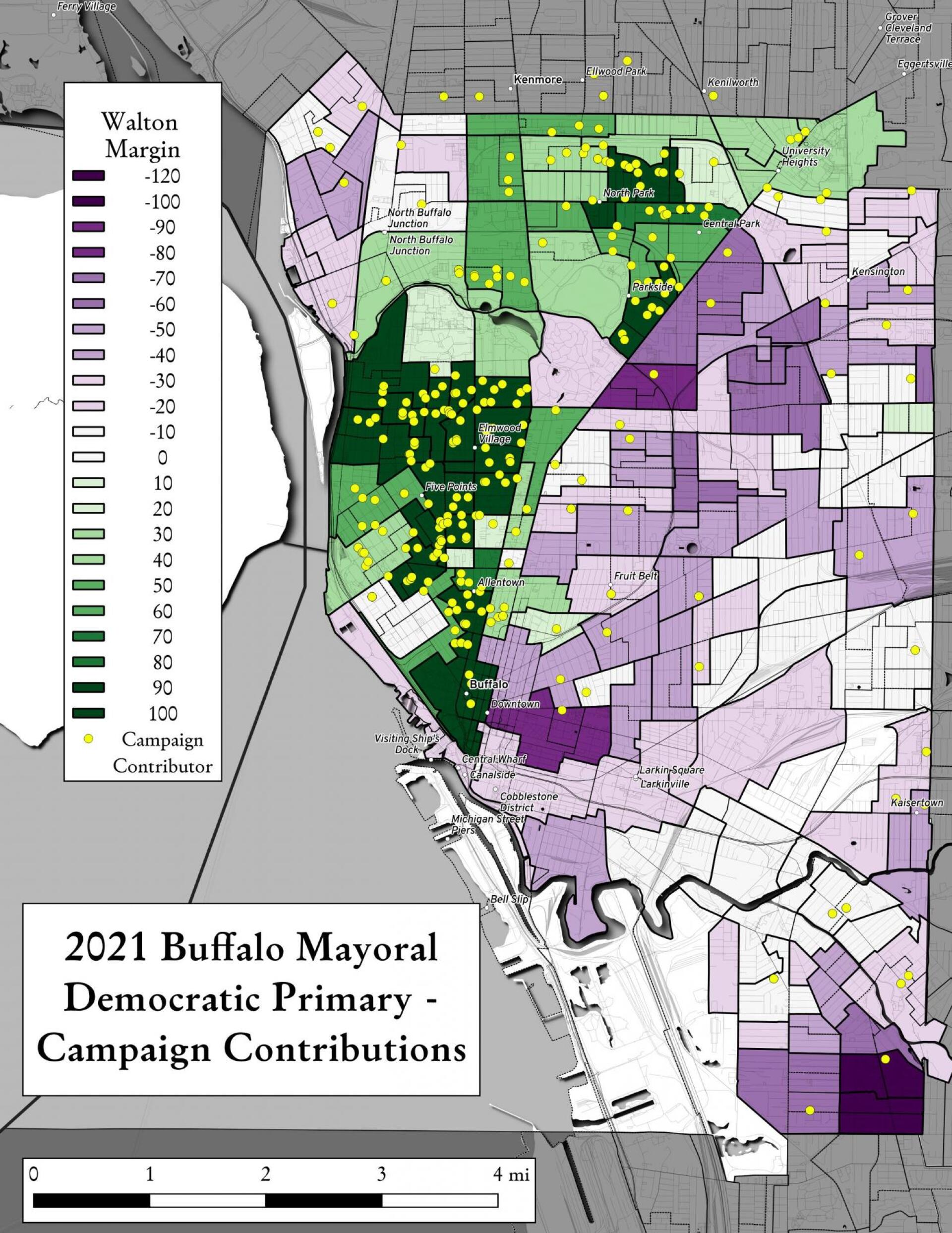
Map showing Buffalo Mayoral Primary results and campaign donors.
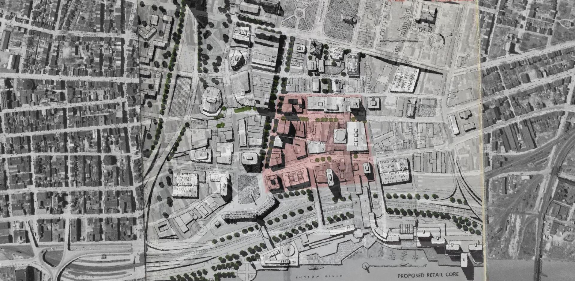
Overlay of Proposed Retail Core in 1963 Plan for the Capital City.

Map showing Local Area Unemployment Statistics – April 2020.
Interactive tax map in Delmar
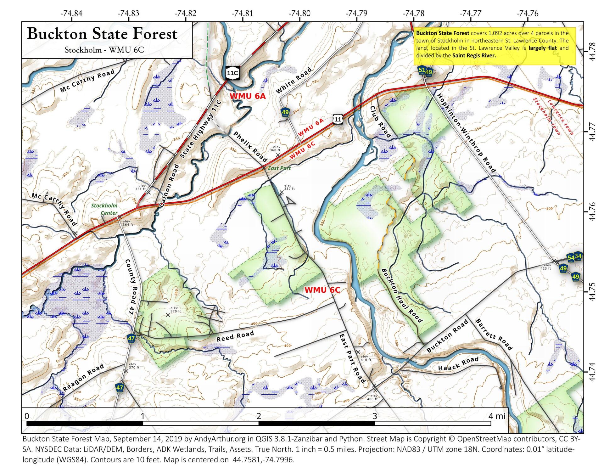
State Land in Stockholm, NY – Buckton State Forest.
Empire State Plaza take area, 1952
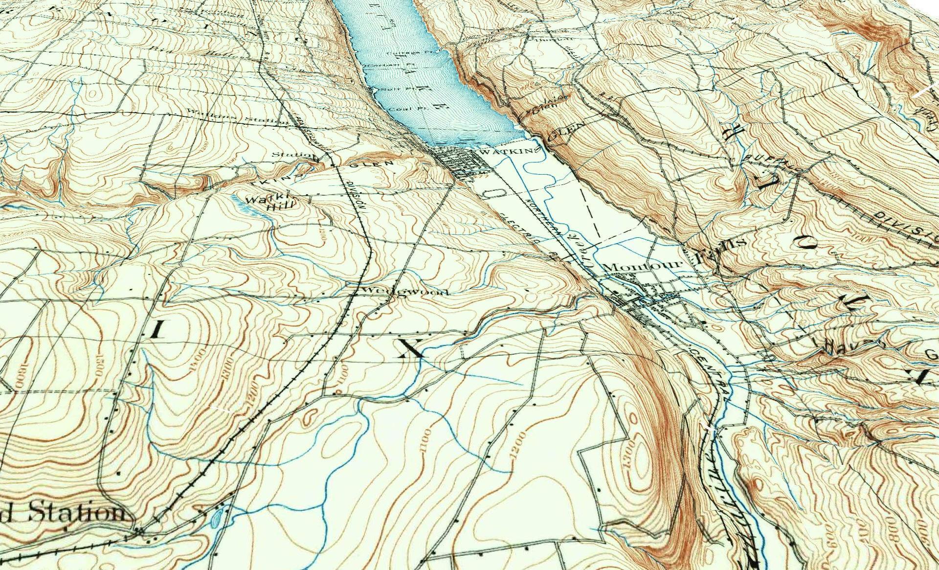
3D Rendering of the 1898 Watkins Glen Topographic Map
Properties in Albany Pine Bush Study Area,Excel Files: Various Tax Rolls,Find coordinates and political districts,Look Up State Tax Records and aScript for Processing RPTL 1520 PDFs.
Querying state property database, political enrollments, PL 94-171 Census files, calculating population statistics, what address is a district in, converting old districts to new districts.
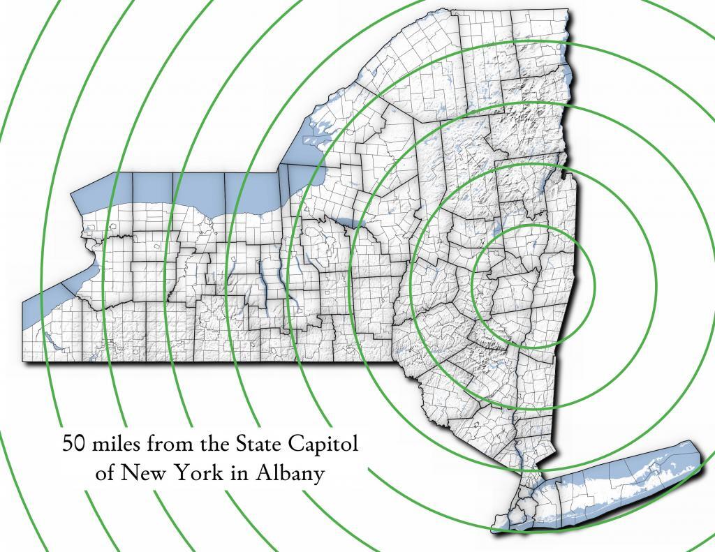
| Miles from Albany | millions population |
| 50 | 1.002 |
| 100 | 1.750 |
| 150 | 3.511 |
| 200 | 17.102 |
| 250 | 17.725 |
| 300 | 18.699 |
| 350 | 19.411 |
| 400 | 20.187 |
| 450 | 20.201 |
import pandas as pd
import geopandas as gpd

# path to overlay shapefile
overlayshp = r'/tmp/dis_to_albany.gpkg'

# summary level -- 750 is tabulation block, 150 is blockgroup
# large areas over about 50 miles much faster to use bg
summaryLevel = 150
#summaryLevel = 750

# path to block or blockgroup file
if summaryLevel == 150:
    blockshp = r'/home/andy/Documents/GIS.Data/census.tiger/36_New_York/tl_2020_36_bg20.shp.gpkg'
else:
    blockshp = r'/home/andy/Documents/GIS.Data/census.tiger/36_New_York/tl_2020_36_tabblock20.shp.gpkg'

# path to PL 94-171 redistricting geoheader file
pl94171File = '/home/andy/Desktop/nygeo2020.pl'

# field to categorize on (such as Ward -- required!)
catField = 'Name'

# geo header contains 2020 census population in column 90
# per PL 94-171 documentation, low memory chunking disabled
# as it causes issues with the geoid column being mixed types
df=pd.read_csv(pl94171File,delimiter='|',header=None, low_memory=False )

# column 2 is summary level
population=df[(df.iloc[:,2] == summaryLevel)][[9,90]]

# load overlay
overlay = gpd.read_file(overlayshp).to_crs(epsg='3857')

# shapefile of nys 2020 blocks, IMPORTANT (!) mask by output file for speed
blocks = gpd.read_file(blockshp,mask=overlay).to_crs(epsg='3857')

# geoid for linking to shapefile is column 9
joinedBlocks=blocks.set_index('GEOID20').join(population.set_index(9))

# store the size of unbroken blocks
# in case overlay lines break blocks into two
joinedBlocks['area']=joinedBlocks.area

# run union
unionBlocks=gpd.overlay(overlay, joinedBlocks, how='union')

# drop blocks outside of overlay
unionBlocks=unionBlocks.dropna(subset=[catField])

# create population projection when a block crosses
# an overlay line -- avoid double counting -- this isn't perfect
# as we loose a 0.15 percent due to floating point errors
unionBlocks['sublock']=unionBlocks[90]*(unionBlocks.area/unionBlocks['area'])

# sum blocks in category
unionBlocks=pd.DataFrame(unionBlocks.groupby(catField).sum()['sublock'])

# rename columns
unionBlocks=unionBlocks.rename({'sublock': '2020 Census Population'},axis=1)

# calculate cumulative sum as you go out each ring
unionBlocks['millions']=unionBlocks.cumsum(axis=0)['2020 Census Population']/1000000

# each ring is 50 miles
unionBlocks['miles']=unionBlocks.index*50

# output
unionBlocks
Most highly assessed properties in Albany County …
from arcgis.features import FeatureLayer
lyr_url = 'https://gisservices.its.ny.gov/arcgis/rest/services/NYS_Tax_Parcel_Centroid_Points/MapServer/0'
layer = FeatureLayer(lyr_url)
query_result1 = layer.query(where="COUNTY_NAME='Albany' AND FULL_MARKET_VAL > 100000000",
                                    out_fields='PARCEL_ADDR,CITYTOWN_NAME,FULL_MARKET_VAL,OWNER_TYPE', out_sr='4326')

df=query_result1.sdf.sort_values(by='FULL_MARKET_VAL', ascending=False)
df['Full Market Value'] = df['FULL_MARKET_VAL'].map('${:,.0f}'.format)

df
| OBJECTID | PARCEL_ADDR | CITYTOWN_NAME | FULL_MARKET_VAL | OWNER_TYPE | SHAPE | Full Market Value | |
|---|---|---|---|---|---|---|---|
| 11 | 26652 | 64 Eagle St | Albany | 1204254925 | 2 | {“x”: -73.75980312511581, “y”: 42.650469918250… | $1,204,254,925 |
| 3 | 9150 | 1200 Washington Ave | Albany | 886298715 | 2 | {“x”: -73.81092293494828, “y”: 42.679257168282… | $886,298,715 |
| 4 | 10208 | 1400 Washington Ave | Albany | 642398287 | 2 | {“x”: -73.82369286130952, “y”: 42.685845700657… | $642,398,287 |
| 0 | 885 | 251 Fuller Rd | Albany | 440042827 | 2 | {“x”: -73.83559002316825, “y”: 42.690208093507… | $440,042,827 |
| 5 | 18164 | 632 New Scotland Ave | Albany | 377568201 | 8 | {“x”: -73.80381341626146, “y”: 42.655758957669… | $377,568,201 |
| 1 | 906 | 141 Fuller Rd | Albany | 321199143 | 2 | {“x”: -73.83323986150171, “y”: 42.693189748928… | $321,199,143 |
| 19 | 108087 | See Card 1067 | Watervliet | 280898876 | 1 | {“x”: -73.70670724174552, “y”: 42.719628647232… | $280,898,876 |
| 15 | 65380 | 737 Alb Shaker Rd | Colonie | 263916100 | 3 | {“x”: -73.80365248218001, “y”: 42.747956678125… | $263,916,100 |
| 9 | 21923 | 304 Madison Ave | Albany | 234265418 | 2 | {“x”: -73.76227373289564, “y”: 42.648000674457… | $234,265,418 |
| 2 | 907 | 201 Fuller Rd | Albany | 203426124 | 2 | {“x”: -73.83362605353057, “y”: 42.692609131686… | $203,426,124 |
| 16 | 69999 | 515 Loudon Rd | Colonie | 166065600 | 8 | {“x”: -73.74958475282632, “y”: 42.719321807666… | $166,065,600 |
| 7 | 20592 | 47 New Scotland Ave | Albany | 162276338 | 8 | {“x”: -73.77597163421673, “y”: 42.653565689693… | $162,276,338 |
| 6 | 20574 | 132 S Lake Ave | Albany | 146296360 | 2 | {“x”: -73.77970918544908, “y”: 42.654390366929… | $146,296,360 |
| 8 | 20597 | 113 Holland Ave | Albany | 143498501 | 2 | {“x”: -73.77306688593143, “y”: 42.650762742870… | $143,498,501 |
| 17 | 78203 | Mannsville | Colonie | 142570400 | 1 | {“x”: -73.71245452369443, “y”: 42.718124477080… | $142,570,400 |
| 18 | 95509 | 1 Crossgates Mall Rd | Guilderland | 130554700 | 8 | {“x”: -73.84702700595471, “y”: 42.687699053797… | $130,554,700 |
| 10 | 24521 | 86 S Swan St | Albany | 128436403 | 2 | {“x”: -73.75980563770365, “y”: 42.653931892804… | $128,436,403 |
| 13 | 46883 | 1916 US 9W | Coeymans | 110000000 | 8 | {“x”: -73.83388475575597, “y”: 42.488730743021… | $110,000,000 |
| 12 | 35152 | 380 River Rd | Bethlehem | 105263158 | 8 | {“x”: -73.76445503554325, “y”: 42.595925419330… | $105,263,158 |
| 14 | 65097 | 15 Wolf Rd | Colonie | 101967213 | 8 | {“x”: -73.81423716588279, “y”: 42.709939498581… | $101,967,213 |
Good evening! Partly clear and 56 degrees at Mason Lake. There is a north breeze at 7 mph. 🍃. New campsite, new location to comply with the maximum three night stay at any one location.
I was actually curious if the state camping regulations had location defined. ⛺ Looking through the state code it’s not defined anywhere in law, indeed on the DEC website they use the word place rather than location – which actually is a more vague term. While this campsite is clearly a different location and it’s even a different unit and near a different geographic location it is technically the same road, 5 miles north. It’s kind of a moot point because last week the Forest Ranger was fine with it I was wondering if there was clear statutory guidance. I think moving from one campsite to another across the street wouldn’t count but within reason a few miles away counts as a new location. A lot of people seem interested in the campsite I’ve been staying at previous nights and now its free. 📝
Hiking back to Wilcox Vly was nice. 📷 Lots of big moose prints on the trail and when I got back to the Vly I heard something big crashing through the brush. Maybe it was a black bear 🐻 but it sure sounded like a moose. I tried to spot it with the binoculars but I didn’t get a good view. Based on the wear of the trail it seems like Wilcox Vly isn’t real popular but it’s easy to follow 👣 due to being an actively maintained snowmobile trail and old woods road. Certainly didn’t see a single other person beyond Fawn Lake. Pictures to be posted later in the week. 📷
I did look at the Robert Garrow campsite ❤🔪 but decided against it due to the poor cellular service 📶. It had great sun exposure compared to the site I’m up at Mason Lake but I’ll try to conserve power tomorrow. I could move the truck to a sunny spot or even drive down to Speculator but I’d rather try to work from camp and save the 10 mile trip each way. 🔟 Tuesday I’ll probably take down camp at work in Speculator until five then go home. 🏡 I could stay at this campsite through Wednesday morning but I’m getting tired and think after five nights I’d rather sleep and work at home for a few days. Not sure when my office will be reopening but I wouldn’t be surprised if thst happens next week and that’s the end of remote work. Fun while it lasted.
Called mom up to check and see how she was doing. 📞 I know they’re pretty bummed about Eli the dog dying. 🐶 I think it’s a mistake to get that invested in a dog but he was fun to walk and run downstairs and do the wash. It’s kind of sad how he passed away while I was gone during the pandemic. I told my parents that I might go out and visit them next week while maintaining social distancing. 👪 I’m hoping soon things will get closer to normal.
Tonight will be mostly clear 🌃, with a low of 42 degrees at 6am. 12 degrees below normal, which is similar to a typical night around April 30th. North wind 5 to 7 mph becoming calm after midnight. In 2019, we had mostly clear skies. It got down to 53 degrees. The record low of 38 occurred back in 1951.
I decided against a fire 🔥 (shocking) and hooking up the electric lights or the flags tonight as I’m tired 😴 and want to keep things simple and get to bed early. My energy levels are low after hiking and it’s kind of a chilly night so I want to get to bed early as I’ve been waking up early on these sunny mornings and not getting enough sleep.
Plus this gives me an excuse to run the lantern 🏮 full blast to try to burn out some of the carbon in the unit. I did try banging and brushing off the mantle outlet that wasn’t putting out much light which was modestly successful. Previously taking apart the lantern last December helped a lot but there is still a lot of carbon build up inside. I usually run the lantern on the lowest setting and between that and the inevitable mud and dirt that gets in it, it gets gross inside with black carbon. At least since the last cleaning it’s not burning a sooty yellow with black smoke and is quite bright 🔆 – fine for reading 📖.
Tonight will have a Waining Gibbous 🌖 Moon with 93% illuminated. The moon will rise at 10:48 pm. The darkest hour is at 12:57 am, followed by dawn at 4:42 am, and sun starting to rise at 5:18 am in the east-northeast (57°) and last for 3 minutes and 31 seconds. Sunrise is 16 seconds earlier than yesterday. 🌄 The golden hour ends at 6:01 am with sun in the east-northeast (64°). Tonight will have 8 hours and 39 minutes of darkness, a decrease of 53 seconds over last night.
Tomorrow will be sunny 🌞, with a high of 68 degrees at 3pm. Eight degrees below normal, which is similar to a typical day around May 12th. Northwest wind 5 to 9 mph. A year ago, we had mostly sunny skies. The high last year was 80 degrees. The record high of 93 was set in 2011.
Should be a nice day for working. 💼 I am right near Mason Lake so I can do some more fishing 🎣 after work. I’m just worried a bit with the shade trees overhead that the laptop may drain the battery bank 🔋 although I do think I’m okay based on the fact that the laptop is 97% charged and it has a good long life estimated – over eight hours and I’ve been saving power on my truck using the gas lamp so that should be close to full come morning. And I’ll use my phone rather than the laptop as much as possible for email and other things to save power.
Tuesday I’ll work down in Speculator 💻 probably using the library Wi-Fi. I’m not worried about power then as it’s expected to be sunny and the solar will more than certainly hold up. Drive home at five. I thought about staying in the Adirondacks through Wednesday 🗻 when the heat wave breaks again but it might be stormy then I’d think I’d rather be home before then.
In four weeks on July 5 the sun will be setting in the west-northwest (303°) at 8:41 pm,🌄 which is 4 minutes and 58 seconds later then tonight. In 2019 on that day, we had hot, humid, partly sunny and temperatures between 92 and 69 degrees. Typically, you have temperatures between 82 and 61 degrees. The record high of 99 degrees was set back in 1919.
Good morning! Monday’s come back around again. Three weeks to Mutts Day. Partly sunny and 76 degrees in Albany. There is a south-southwest breeze at 8 mph. The dew point is 59 degrees.
Looks like a beautiful summer morning. Today should be a nice day but more rain is expected for Tuesday. I guess everyday can’t be perfect. Now the weekend is sliding down hill but that’s still a long ways away and is subject to change.
Tonight will have a slight chance of showers, then a chance of showers and thunderstorms after 2am. Mostly cloudy, with a low of 70 degrees at 3am. Nine degrees above normal. Maximum dew point of 66 at 4am. South wind around 9 mph. Chance of precipitation is 30%. New rainfall amounts of less than a tenth of an inch, except higher amounts possible in thunderstorms. In 2016, we had cloudy skies. It got down to 59 degrees. The record low of 48 occurred back in 1986.
On this day in 1890, Wyoming is admitted to the United States as the 44th US State. Many liberals regard that as a mistake, although it has some beautiful country out in Yellowstone and lots of oil and coal. And in 1962, Telstar, the world’s first communication satellite is launched.
It was pretty last night once the moon started to rise. Lots of moonlight all over the land. Sun came up pretty early and I awoke around 5:30, got up, took a piss and went back to bed for a while.
Truck smelled a little like gasoline while I was camping last night, as I spilled some gasoline over the bed of the truck, as I didn’t have the gas can properly sealed. It was my fault, I didn’t put the cap on right after filling my camp stove at Moose River Plains. Fixed that, and things are still ventalating out, but I had plenty of gas fumes to breathe last night.
I am hoping to get my new phone this evening from the FedEx store. I also ordered a protective case so hopefully I won’t drop it so much and if I do it will be more protected. I also look forward to doing more Instagram photos once again because they are fast and easy and are shared both on social media and the blog.
The more I think about it, the more I’m leaning towards camping at White House. Then I could swim at Wells or Speculator Beach and paddle the flat water of Sacandaga River. Although I wouldn’t mind going back to Pisceo Powley Road again. I do like the trip up there and being farther back in the back country. Assuming that the weather is decent next weekend I have options. Otherwise it’s just another quiet weekend at home before summer vacation in the Finger Lakes.
Thinking about this year bringing my kayak on summer vacation. I usually don’t because I don’t like hauling the kayak all over but in the heat of summer it might be fun to paddle and fish on the various Finger Lakes. What I’m thinking is that once I set up camp I could lock my kayak to a tree so I’m not driving around with it all week. I could do the same thing when I’m at the Allegheny National Forest and are going out to Presque Isle State Park. That way I wouldn’t have to drag the kayak around everywhere.
Today will be mostly sunny, with a high of 85 degrees at 3pm. Three degrees above normal. Maximum dew point of 63 at 6pm. Southwest wind 8 to 11 mph. A year ago, we had cloudy skies. The high last year was 79 degrees. The record high of 100 was set in 1936.
The sun will set at 8:33 pm with dusk around 9:07 pm, which is 29 seconds earlier than yesterday. At sunset, look for partly cloudy conditions and 78 degrees. The dew point will be 64 degrees. There will be a south breeze at 9 mph. Today will have 15 hours and 6 minutes of daytime, an increase of one minute and 14 seconds over yesterday.
As previously noted, there are 3 weeks until Mutts Day when the sun will be setting at 8:15 pm with dusk at 8:47 pm. On that day in 2016, we had rain, drizzle, fog, mist, cloudy skies and temperatures between 71 and 63 degrees. Typically, the high temperature is 82 degrees. We hit a record high of 98 back in 1917.
I woke up around 8:30 AM on Day 3 of Gorging on Gorges. It was cold and wet enough, I decided I needed a full breakfast, even if was only sprinkling out. I decided to make eggs and sausage up, with the works once again. It was a good breakfast. Originally today was supposed to be the day to go to Letchworth State Park, but because of weather, and practical need to spend more days in Finger Lakes if I really wanted to see all the gorges, I ended up staying in the Finger Lakes one more day.
Drove down Potamac Road then Pinic Area Road. I wanted to snap a few pictures of government closure signs, so I could have something for my records. Who knows how long before I will see another government shutdown. They had government shutdown signs posted on the Blueberry Hill Camping Fee Area, and the Interloken Horse Camp, but that’s about it. Most other areas were still open. I was actually more worried about the Allegheny National Forest, for the second half the week, should it still be closed.
I got my picture, along with several other roads on Finger Lakes National Forest. Several were fairly colorful. Then I drove down through Texas Hollow, where there is a state forest in the a remote part of the gorge, surrounded by hunting camps and crossed by the Finger Lakes Trail. The prettiest part of Texas Hollow is actually the northern end, before you get deeper in the hollow, due to the open farm land showing the colors of the trees on the surrounding hills. I wish I could have stopped and got a picture, but the narrow road combined with the terrian, did not make it anything resembling safe.
I left the hollow, and there was a dairy farm, and I was dumped into Cayuta. A bridge closure and the stupid GPS left me lost in Odessa. Next I put into the GPS to take me to Robert Treman State park, via the most direct route. I was honestly hoping to see a bit of Connecticut Hill WMA, although I ended up going past Cayuta Lake, and Cayutaville along the way. I stopped a Cayuta Lake for a bit. Driving through Alpine gave me views of Connecticut Hill and some very rural farm land, but that’s about it. I stopped for a picture, because it was kind of a pretty looking scene.
Made it Robert Treman State Park. I was disappointed to find out the gorge trail into Enfield Glen was closed due to severe weather that washed out of the gorge trail. That said, the South Rim trail was open, so I hiked down to the overlook for Lucifer Falls then partially down The Stairs. The view from The Stairs into the gorge was quite colorful, especially in light of the fog that was hanging over the area.
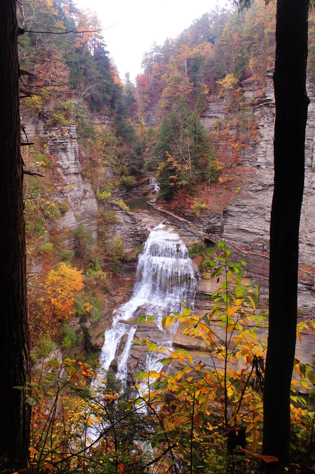
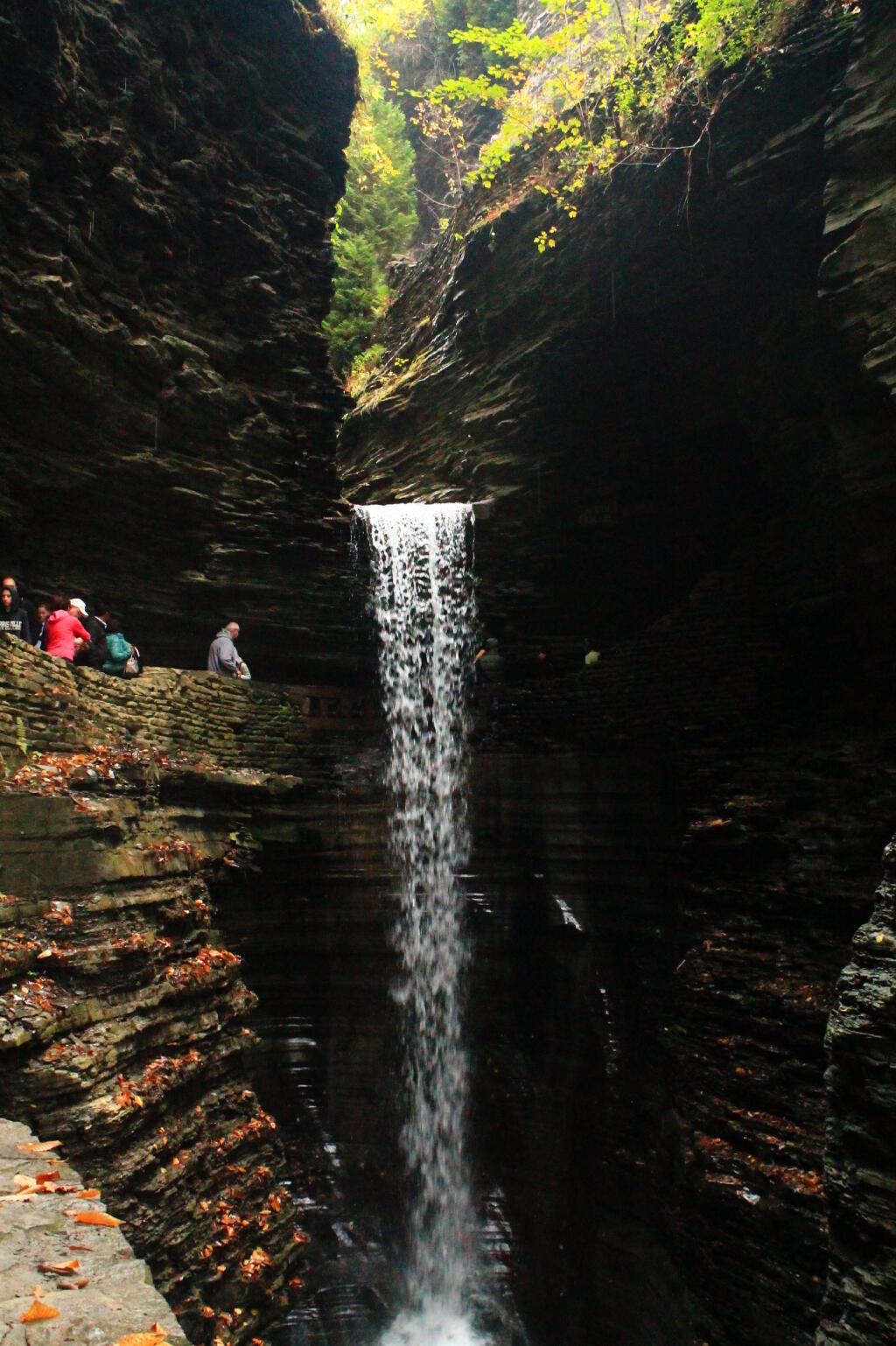
Next it was off to Watkins Glen. Part of Watkins Glen was starting to turn quite colorful, with yellows really sticking out. It was Columbus Day, so the glen was pretty packed, although once you got past the Mile Point Bridge, the crowded started to drop off. Hiked back via the North Rim Trail which is an old carriage road, with several overlooks to the gorge. It was getting late. I stopped at the P&C in Watkins Glen and picked up a few more groceries, and got more gas – I burned up a lot of it –- then headed up to Sugar Hill State Forest. I had hoped to swing past the firetower, but as I climbed out of Watkins Glen into the hills above it, I drove into a deep fog, and figured it wasn’t even worth driving that ½ mile to get up there.
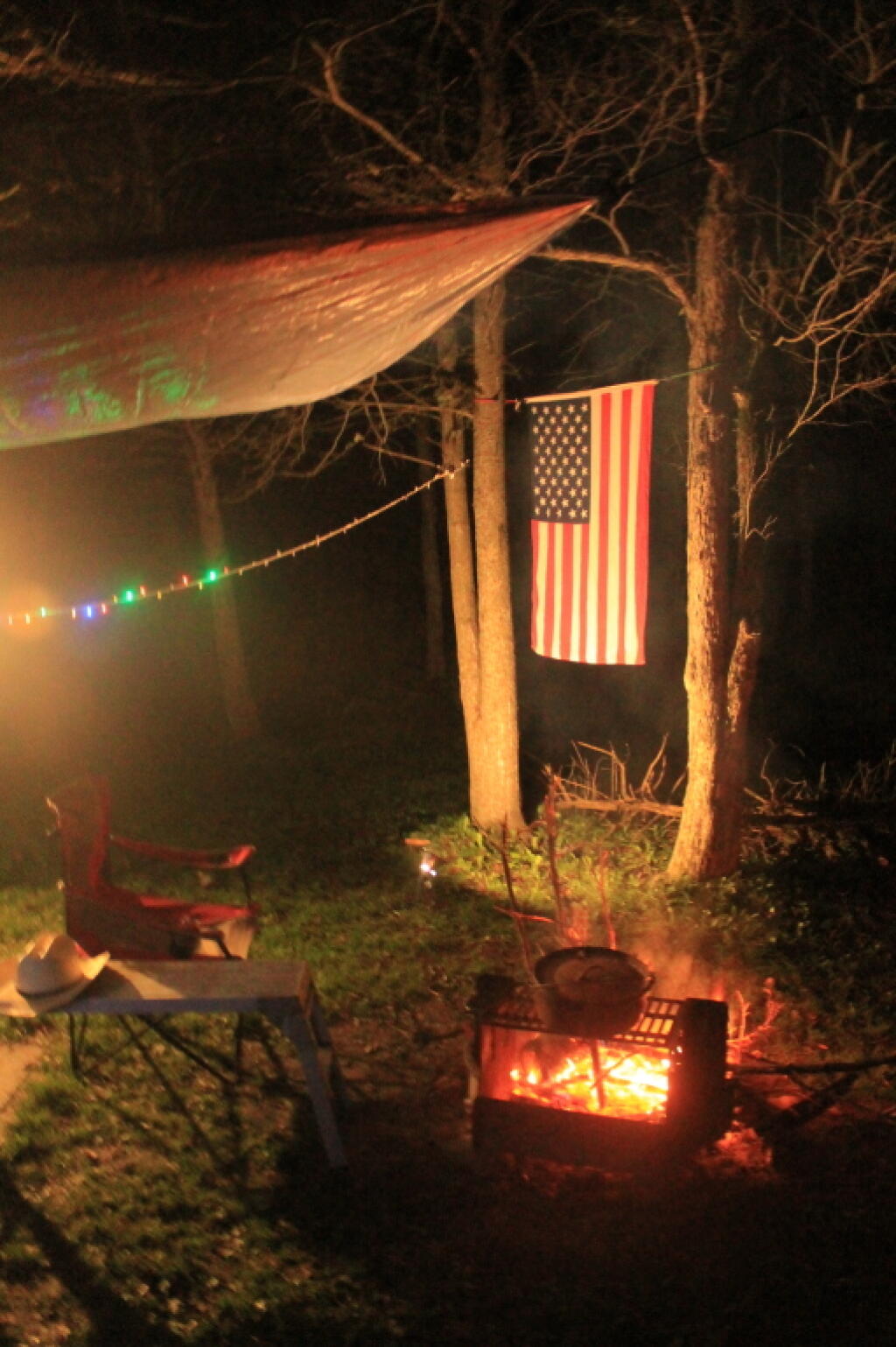
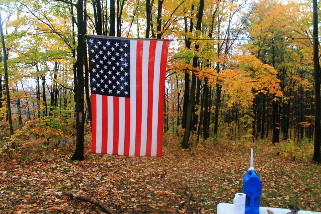
Decided to camp down at the Lower Assembly-area. Columbus Day Weekend was over, the horses and horse trailers were all gone. It did smell like horse shit, but of course it’s a state horse camp, so that’s to be expected. Hung up a tarp tonight, because I was sure it would rain, but of course it did not. Got the flag up, quickly gathered some firewood, built a few, cooked some dinner on the picnic table. Stayed up to around 10 PM, then went to bed, as I knew I had a real big day for number four.