Search Results for: west capital park

USGS Topographic Maps – Albany to Delaware Counties

Counties: Albany to Delaware / Dutchess to Livingston / Madison to Otsego / Putnam to Suffolk / Sullivan to Yates

Browse Topographic Maps: Full State / Historical USGS Topographic Maps

Albany County

PDF (50-60 MB Download) Historical USGS Topo Maps State Lands (Links to DEC Website) Towns (Percent of Town’s Area)
Current Albany GeoPDF Map
1953 Map No. 136552, 1953 Map No. 136553, 1953 Map No. 136559, 1978 Map No. 136558, 1994 Map No. 137061 Albany Pine Bush Preserve Albany city (85%), Bethlehem (14%), Colonie (41%), Guilderland (7%), New Scotland (2%), Rensselaer city (3%)
Current Alcove GeoPDF Map
1953 Map No. 136571, 1953 Map No. 136572, 1953 Map No. 136573 Coxsackie FP Detached Parcel, Greenville FP Detached Parcel Coeymans (33%), Coxsackie (6%), Greenville (30%), New Baltimore (39%), Westerlo (12%)
Current Altamont GeoPDF Map
1944 Map No. 136597, 1944 Map No. 136598, 1944 Map No. 136599, 1944 Map No. 136602 Margaret Burke WMA Berne (12%), Duanesburg (3%), Guilderland (30%), Knox (60%), New Scotland (4%), Princetown (1%)
Current Clarksville GeoPDF Map
1953 Map No. 137631, 1953 Map No. 137632, 1953 Map No. 137633, 1953 Map No. 137634 Five Rivers Environmental Education Center, Louise E. Keir WMA Bethlehem (4%), Coeymans (24%), New Scotland (62%), Westerlo (7%)
Current Delmar GeoPDF Map
1953 Map No. 137861, 1953 Map No. 137862, 1953 Map No. 137863, 1953 Map No. 137865, 1953 Map No. 137866, 1978 Map No. 137864 Coeymans Creek WMA, Onesquethaw Creek Fishing Access Albany city (2%), Bethlehem (81%), Coeymans (19%), East Greenbush (5%), New Scotland (0%), Rensselaer city (8%), Schodack (4%)
Current Durham GeoPDF Map
1945 Map No. 137938, 1946 Map No. 137933, 1946 Map No. 137934, 1967 Map No. 137937 Catskill Creek Fishing Access, Mount Hayden State Forest, Mount Pisgah State Forest, Scott Patent State Forest, Rensselaerville State Forest Broome (4%), Conesville (0%), Durham (36%), Rensselaerville (57%), Windham (0%)
Current Gallupville GeoPDF Map
1944 Map No. 137216, 1944 Map No. 138096, 1944 Map No. 138097 Dutch Settlement State Forest Berne (3%), Duanesburg (16%), Knox (40%), Schoharie (2%), Wright (83%)
Current Greenville GeoPDF Map
1945 Map No. 129624, 1945 Map No. 129625, 1946 Map No. 129626, 1980 Map No. 129627 NA Durham (16%), Greenville (42%), Rensselaerville (11%), Westerlo (41%)
Current Livingstonville GeoPDF Map
1945 Map No. 130298, 1945 Map No. 130301, 1946 Map No. 130299, 1962 Map No. 130300 South Mountain State Forest, Mount Pisgah State Forest, Stone Store State Forest, Keyserkill State Forest, Scott Patent State Forest, High Knob State Forest, Leonard Hill State Forest, Dutton Ridge State Forest, Bates State Forest Broome (42%), Conesville (64%), Durham (0%), Gilboa (13%), Rensselaerville (2%), Windham (0%)
Current Niskayuna GeoPDF Map
1954 Map No. 128733, 1954 Map No. 128734, 1954 Map No. 128735, 1954 Map No. 137464 NA Clifton Park (58%), Colonie (22%), Halfmoon (17%), Niskayuna (48%)
Current Ravena GeoPDF Map
1953 Map No. 136024, 1953 Map No. 136025, 1953 Map No. 136026 Bronck Island, Hannacroix Unique Area, Van Schaak Unique Area, New Baltimore FP Detached Parcel, Nutten Hook State Tidal Wetland, Coeymans Creek WMA Coeymans (25%), Coxsackie (3%), New Baltimore (61%), Schodack (7%), Stuyvesant (38%)
Current Rensselaerville GeoPDF Map
1946 Map No. 136056, 1946 Map No. 136057 Dutch Settlement State Forest, Rensselaerville State Forest, Partridge Run State Forest, Partridge Run WMA Berne (42%), Broome (9%), Middleburgh (12%), Rensselaerville (26%), Wright (5%)
Current Schenectady GeoPDF Map
1954 Map No. 129430, 1954 Map No. 129431, 1954 Map No. 129433, 1954 Map No. 129434 Albany Pine Bush Preserve Clifton Park (4%), Colonie (4%), Glenville (32%), Guilderland (3%), Niskayuna (52%), Princetown (0%), Rotterdam (36%), Schenectady city (100%)
Current Troy North GeoPDF Map
1954 Map No. 139377, 1954 Map No. 139378, 1954 Map No. 139379, 1954 Map No. 139381, 1978 Map No. 139380 NA Brunswick (12%), Cohoes city (100%), Colonie (12%), Green Island (42%), Halfmoon (45%), Schaghticoke (23%), Troy city (30%), Waterford (100%)
Current Troy South GeoPDF Map
1953 Map No. 139382, 1953 Map No. 139383, 1953 Map No. 139384, 1953 Map No. 139386, 1953 Map No. 139387, 1978 Map No. 139385 NA Albany city (8%), Brunswick (12%), Colonie (18%), East Greenbush (28%), Green Island (58%), North Greenbush (91%), Rensselaer city (84%), Sand Lake (1%), Troy city (70%), Watervliet city (100%)
Current Voorheesville GeoPDF Map
1954 Map No. 139503, 1954 Map No. 139504, 1954 Map No. 139505 Albany Pine Bush Preserve, Black Creek Marsh WMA Albany city (4%), Bethlehem (0%), Colonie (3%), Guilderland (59%), New Scotland (30%)
Current Westerlo GeoPDF Map
1943 Map No. 137019, 1943 Map No. 140234, 1943 Map No. 140235 Cole Hill State Forest, Partridge Run WMA Berne (43%), New Scotland (3%), Rensselaerville (3%), Westerlo (40%)

Allegany County

PDF (50-60 MB Download) Historical USGS Topo Maps State Lands (Links to DEC Website) Towns (Percent of Town’s Area)
Current Alfred GeoPDF Map
1964 Map No. 136588, 1964 Map No. 136589, 1964 Map No. 136590 Phillips Creek State Forest, Hiltonville State Forest, Palmer’s Pond State Forest, Karr Valley Creek State Forest, Turnpike State Forest, Bully Hill State Forest, Klipnocky State Forest Alfred (33%), Almond (63%), Birdsall (9%), Ward (5%), West Almond (30%)
Current Allentown GeoPDF Map
1965 Map No. 136592, 1965 Map No. 137063 Alma Pond Alma (63%), Bolivar (43%), Scio (24%), Wellsville (4%), Wirt (19%)
Current Andover GeoPDF Map
1965 Map No. 136637, 1965 Map No. 137077 Vandermark State Forest, Phillips Creek State Forest Alfred (56%), Andover (70%), Ward (25%), Wellsville (8%)
Current Angelica GeoPDF Map
1964 Map No. 136644, 1964 Map No. 136645, 1964 Map No. 136646 Coyle Hill State Forest, Allen Lake State Forest Allen (20%), Amity (8%), Angelica (63%), Belfast (43%), Caneadea (13%), Friendship (5%)
Current Arkport GeoPDF Map
1965 Map No. 136691, 1965 Map No. 136692, 1965 Map No. 136693 NA Almond (4%), Burns (22%), Dansville (62%), Fremont (24%), Hornell city (10%), Hornellsville (14%), Ossian (7%)
Current Belmont GeoPDF Map
1965 Map No. 123245, 1965 Map No. 123246 Coyle Hill State Forest Amity (58%), Friendship (38%), Scio (36%), Wellsville (1%), Wirt (24%)
Current Birdsall GeoPDF Map
1964 Map No. 123309, 1964 Map No. 123311 English Hill State Forest, Gillies Hill State Forest, Keeney Swamp State Forest, Gas Springs State Forest, Rattlesnake Hill WMA, Keeney Swamp WMA Allen (26%), Birdsall (48%), Granger (32%), Grove (55%)
Current Black Creek GeoPDF Map
1964 Map No. 123312, 1964 Map No. 123313, 1964 Map No. 137111 Crab Hollow State Forest, Rush Creek State Forest, Hanging Bog WMA – Showy Lady Slipper, Hanging Bog WMA Belfast (57%), Caneadea (17%), Cuba (6%), Friendship (7%), New Hudson (50%), Rushford (15%)
Current Bliss GeoPDF Map
1966 Map No. 123318, 1966 Map No. 123319 Lost Nation State Forest Arcade (43%), Centerville (13%), Eagle (50%), Freedom (12%), Java (9%), Wethersfield (10%)
Current Bolivar GeoPDF Map
1965 Map No. 123114, 1965 Map No. 123338 NA Bolivar (57%), Clarksville (22%), Genesee (50%), Wirt (25%)
Current Canaseraga GeoPDF Map
1964 Map No. 122771 Ossian State Forest, Canaseraga State Forest, Hiltonville State Forest, Klipnocky State Forest, Gas Springs State Forest, Slader Creek State Forest, Rattlesnake Hill WMA, Keeney Swamp WMA Almond (21%), Birdsall (21%), Burns (78%), Grove (24%), Ossian (22%)
Current Cuba GeoPDF Map
1961 Map No. 137759, 1961 Map No. 137760, 1961 Map No. 137761, 1961 Map No. 137762 NA Clarksville (28%), Cuba (43%), Hinsdale (48%), Ischua (28%), Oil Springs Reservation (100%), Oil Springs Reservation (100%), Portville (3%)
Current Fillmore GeoPDF Map
1964 Map No. 138145, 1964 Map No. 138146 English Hill State Forest, Allen Lake State Forest Allen (43%), Caneadea (30%), Granger (50%), Hume (33%)
Current Freedom GeoPDF Map
1963 Map No. 137211, 1963 Map No. 137212, 1963 Map No. 138173 Lost Nation State Forest, Bush Hill State Forest, Farmersville State Forest, Harwood Lake Mua Centerville (37%), Farmersville (30%), Freedom (37%), Rushford (35%)
Current Friendship GeoPDF Map
1965 Map No. 138182, 1965 Map No. 138183 NA Clarksville (28%), Cuba (44%), Friendship (50%), Wirt (31%)
Current Greenwood GeoPDF Map
1965 Map No. 129641, 1965 Map No. 129642, 1978 Map No. 129643 Rock Creek State Forest, Greenwood State Forest Alfred (6%), Andover (4%), Canisteo (0%), Greenwood (67%), Hartsville (66%)
Current Hornell GeoPDF Map
1965 Map No. 129772, 1965 Map No. 129773, 1978 Map No. 129771 Canacadea State Forest, Bully Hill State Forest Alfred (4%), Almond (11%), Fremont (4%), Hartsville (33%), Hornell city (90%), Hornellsville (75%)
Current Houghton GeoPDF Map
1964 Map No. 129789, 1964 Map No. 129790, 1978 Map No. 129788 Lost Nation State Forest, Swift Hill State Forest Caneadea (39%), Centerville (38%), Hume (39%), Rushford (35%)
Current Nunda GeoPDF Map
1943 Map No. 128828, 1972 Map No. 128834, 1972 Map No. 137474 Rattlesnake Hill WMA Castile (1%), Granger (9%), Grove (15%), Mount Morris (12%), Nunda (70%), Portage (54%)
Current Ossian GeoPDF Map
1943 Map No. 135910, 1972 Map No. 135911 Ossian State Forest, Canaseraga State Forest, Rattlesnake Hill WMA Grove (6%), Mount Morris (3%), Nunda (30%), Ossian (54%), West Sparta (55%)
Current Pike GeoPDF Map
1943 Map No. 128996, 1972 Map No. 128998, 1972 Map No. 136801 Wiscoy Creek Fishing Access, Lost Nation State Forest, Cold Creek State Forest Centerville (13%), Eagle (50%), Gainesville (10%), Hume (13%), Pike (64%), Wethersfield (9%)
Current Portageville GeoPDF Map
1943 Map No. 129125, 1972 Map No. 129128, 1972 Map No. 129129, 1972 Map No. 129131 East Koy Creek Fishing Access, Wiscoy Creek Fishing Access, Genesee Valley WMA Castile (11%), Gainesville (8%), Genesee Falls (100%), Granger (10%), Hume (15%), Mount Morris (0%), Pike (36%), Portage (46%)
Current Portville GeoPDF Map
1961 Map No. 129134, 1961 Map No. 129135, 1961 Map No. 136828 NA Clarksville (22%), Genesee (50%), Portville (82%)
Current Rawson GeoPDF Map
1963 Map No. 136027, 1963 Map No. 136028 Crab Hollow State Forest, Bush Hill State Forest, Hanging Bog WMA Cuba (6%), Farmersville (13%), Ischua (8%), Lyndon (61%), New Hudson (50%), Rushford (15%)
Current Rexville GeoPDF Map
1965 Map No. 136058, 1965 Map No. 136059 NA Andover (1%), Greenwood (25%), Independence (2%), Troupsburg (5%), West Union (100%)
Current Wellsville North GeoPDF Map
1965 Map No. 137002, 1965 Map No. 140121, 1965 Map No. 140122 Vandermark State Forest, Phillips Creek State Forest, Plumbottom State Forest Amity (30%), Andover (4%), Scio (41%), Ward (60%), Wellsville (32%)
Current Wellsville South GeoPDF Map
1965 Map No. 140123, 1965 Map No. 140124 Wag Trail, Alma Pond, Genesee River Wildlife Management Area Alma (37%), Wellsville (47%), Willing (70%)
Current West Almond GeoPDF Map
1964 Map No. 140125, 1964 Map No. 140126 Jersey Hill State Forest, Phillips Creek State Forest, Hiltonville State Forest, Palmer’s Pond State Forest, Karr Valley Creek State Forest, Turnpike State Forest, Gillies Hill State Forest, Bald Mountain State Forest Allen (12%), Amity (4%), Angelica (37%), Birdsall (22%), Ward (11%), West Almond (70%)
Current Whitesville GeoPDF Map
1965 Map No. 137029, 1965 Map No. 140293 Wag Trail Andover (21%), Independence (98%), Wellsville (9%), Willing (30%)

Bronx County

PDF (50-60 MB Download) Historical USGS Topo Maps State Lands (Links to DEC Website) Towns (Percent of Town’s Area)
Current Central Park GeoPDF Map
1947 Map No. 122894, 1956 Map No. 122895, 1956 Map No. 122896, 1966 Map No. 122897, 1966 Map No. 122898, 1966 Map No. 122899, 1966 Map No. 122900, 1995 Map No. 137165 Bronx River Trail Bronx borough (31%), Manhattan borough (68%), Queens borough (7%)
Current Flushing GeoPDF Map
1947 Map No. 138246, 1947 Map No. 138247, 1955 Map No. 138248, 1955 Map No. 138249, 1966 Map No. 137330, 1966 Map No. 138250, 1966 Map No. 138251, 1966 Map No. 138252, 1995 Map No. 137332 Bronx River Trail Bronx borough (42%), North Hempstead (2%), Queens borough (17%)
Current Mount Vernon GeoPDF Map
1956 Map No. 130718, 1956 Map No. 130719, 1966 Map No. 130720, 1966 Map No. 130721, 1966 Map No. 130722, 1966 Map No. 130723, 1995 Map No. 137393 Titus Mill Pond State Tidal Wetland Bronx borough (13%), Eastchester (100%), Greenburgh (11%), Mamaroneck (48%), Mount Vernon city (100%), New Rochelle city (100%), Pelham (100%), Scarsdale (74%), White Plains city (2%), Yonkers city (60%)
Current Yonkers GeoPDF Map
1966 Map No. 140393, 1966 Map No. 140394, 1998 Map No. 137051 NA Bronx borough (14%), Greenburgh (5%), Manhattan borough (1%), Orangetown (0%), Yonkers city (40%)

Broome County

PDF (50-60 MB Download) Historical USGS Topo Maps State Lands (Links to DEC Website) Towns (Percent of Town’s Area)
Current Afton GeoPDF Map
1957 Map No. 136536, 1957 Map No. 136537, 1957 Map No. 136538, 1957 Map No. 137055 Beaver Pond State Forest, Melondy Hill State Forest, Marsh Pond State Forest, Susquehanna River Boat Launch Afton (49%), Colesville (28%), Coventry (3%), Sanford (10%), Windsor (0%)
Current Belden GeoPDF Map
1957 Map No. 123233 Beaver Flow State Forest Afton (3%), Colesville (62%), Coventry (2%), Fenton (9%), Greene (0%), Windsor (1%)
Current Binghamton East GeoPDF Map
1937 Map No. 123290, 1937 Map No. 123291, 1961 Map No. 123294, 1968 Map No. 123295, 1968 Map No. 123296 Kirkwood Sub-Office, Skyline Drive State Forest Binghamton city (9%), Binghamton (8%), Conklin (98%), Kirkwood (73%), Windsor (7%)
Current Binghamton West GeoPDF Map
1935 Map No. 123297, 1961 Map No. 123299, 1968 Map No. 123300, 1968 Map No. 123301, 1968 Map No. 137107 NA Binghamton city (89%), Binghamton (92%), Conklin (2%), Dickinson (25%), Kirkwood (0%), Union (10%), Vestal (33%)
Current Castle Creek GeoPDF Map
1934 Map No. 122840, 1942 Map No. 122841, 1961 Map No. 122846, 1968 Map No. 122847, 1968 Map No. 122848 NA Barker (12%), Binghamton city (2%), Chenango (72%), Dickinson (75%), Fenton (4%), Kirkwood (0%), Maine (26%), Nanticoke (5%), Union (20%)
Current Chenango Forks GeoPDF Map
1935 Map No. 122947, 1942 Map No. 122948, 1960 Map No. 122954, 1968 Map No. 122955, 1968 Map No. 122956 NA Barker (3%), Chenango (28%), Colesville (9%), Fenton (87%), Greene (1%), Kirkwood (24%), Windsor (0%)
Current Deposit GeoPDF Map
1965 Map No. 137205, 1965 Map No. 137880 Oquaga Creek Fishing Access, Lower West Branch Delaware River Fishing Access, West Branch Delaware River Waterway Access, Oquaga Creek Fishing Access, Columbia Lake State Forest, Michigan Hill State Forest, Whitaker Swamp State Forest, Cat Hollow State Forest, West Branch Delaware River Deposit (41%), Sanford (41%)
Current Endicott GeoPDF Map
1956 Map No. 138228, 1956 Map No. 138229, 1969 Map No. 137326, 1969 Map No. 138234, 1969 Map No. 138235 Tracy Creek State Forest Owego (7%), Union (37%), Vestal (67%)
Current Greene GeoPDF Map
1948 Map No. 129612, 1950 Map No. 129613 NA Barker (19%), Greene (58%), Triangle (9%)
Current Gulf Summit GeoPDF Map
1952 Map No. 129660, 1952 Map No. 129661, 1952 Map No. 129662, 1952 Map No. 129663 Beaver Pond State Forest, Marsh Pond State Forest, Cascade Valley State Forest Colesville (1%), Sanford (27%), Windsor (33%)
Current Lisle GeoPDF Map
1949 Map No. 130273, 1949 Map No. 130275, 1951 Map No. 130274 Ketchumville State Forest, Nanticoke Lake Multiple Use Area Berkshire (13%), Lisle (56%), Maine (5%), Nanticoke (73%), Newark Valley (7%), Richford (4%)
Current Maine GeoPDF Map
1956 Map No. 130418, 1956 Map No. 130419, 1969 Map No. 130420, 1969 Map No. 130421, 1969 Map No. 137425 Ketchumville State Forest, Nanticoke Creek Fishing Access Maine (69%), Nanticoke (2%), Newark Valley (18%), Owego (2%), Union (33%)
Current Marathon GeoPDF Map
1950 Map No. 130449, 1950 Map No. 130450, 1950 Map No. 130451, 1950 Map No. 130452, 1950 Map No. 137432 Beaver Dam State Forest, Hoxie Gorge State Forest, James Kennedy State Forest Freetown (13%), Lapeer (66%), Lisle (34%), Marathon (62%), Richford (1%), Virgil (8%)
Current North Sanford GeoPDF Map
1965 Map No. 128768, 1965 Map No. 128769 Arctic China State Forest, Beals Pond State Forest, Michigan Hill State Forest, Steam Mill State Forest, Beaver Pond State Forest, Melondy Hill State Forest Afton (33%), Bainbridge (2%), Deposit (13%), Masonville (25%), Sanford (22%)
Current Smithville Flats GeoPDF Map
1948 Map No. 136183, 1948 Map No. 136184, 1948 Map No. 136185 Genegantslet Creek Fishing Access, Triangle State Forest, Red Brook State Forest, Long Pond State Forest, Genegantslet State Forest, Five Streams State Forest Cincinnatus (1%), German (53%), Greene (4%), McDonough (14%), Smithville (53%), Triangle (5%), Willet (8%)
Current Whitney Point GeoPDF Map
1949 Map No. 137030, 1949 Map No. 140294, 1949 Map No. 140295, 1951 Map No. 140296 Triangle State Forest Barker (66%), Lisle (7%), Nanticoke (20%), Triangle (49%)
Current Willet GeoPDF Map
1949 Map No. 140297, 1951 Map No. 140298 Papish Pond Multiple Use Area, Triangle State Forest Cincinnatus (15%), Freetown (6%), Lisle (4%), Marathon (38%), Triangle (37%), Willet (92%)
Current Windsor GeoPDF Map
1952 Map No. 140350, 1952 Map No. 140351, 1952 Map No. 140352 Skyline Drive State Forest, Hawkins Pond State Forest, Susquehanna Waterway Access Colesville (1%), Kirkwood (2%), Windsor (59%)

Cattaraugus County

PDF (50-60 MB Download) Historical USGS Topo Maps State Lands (Links to DEC Website) Towns (Percent of Town’s Area)
Current Arcade GeoPDF Map
1966 Map No. 136682, 1966 Map No. 136683 NA Arcade (57%), Freedom (12%), Holland (7%), Java (12%), Sardinia (19%), Yorkshire (14%)
Current Ashford GeoPDF Map
1964 Map No. 136703 Boyce Hill State Forest, Bryant Hill State Forest, Golden Hill State Forest Ellicottville (37%), Franklinville (50%), Great Valley (3%), Humphrey (9%), Machias (19%)
Current Ashford Hollow GeoPDF Map
1964 Map No. 136700, 1964 Map No. 136701, 1964 Map No. 136702, 1964 Map No. 710169 NA Ashford (64%), Concord (9%), East Otto (36%), Ellicottville (2%)
Current Bliss GeoPDF Map
1966 Map No. 123318, 1966 Map No. 123319 Lost Nation State Forest Arcade (43%), Centerville (13%), Eagle (50%), Freedom (12%), Java (9%), Wethersfield (10%)
Current Cattaraugus GeoPDF Map
1963 Map No. 122868, 1963 Map No. 122869, 1963 Map No. 137161 Mansfield Creek Fishing Access, Cattaraugus State Forest, Dobbins Memorial State Forest East Otto (8%), Little Valley (8%), Mansfield (59%), Napoli (5%), New Albion (42%), Otto (27%), Persia (1%)
Current Cherry Creek GeoPDF Map
1954 Map No. 122963, 1954 Map No. 122964, 1954 Map No. 137172 NA Cherry Creek (55%), Conewango (6%), Dayton (16%), Ellington (7%), Leon (52%), Villenova (17%)
Current Collins Center GeoPDF Map
1963 Map No. 137682, 1963 Map No. 137683, 1963 Map No. 137684 Cattaraugus Creek Waterway Access, Zoar Valley Multiple Use Area, Zoar Valley Unique Area, East Otto State Forest Collins (35%), Concord (5%), East Otto (37%), Otto (61%)
Current Cuba GeoPDF Map
1961 Map No. 137759, 1961 Map No. 137760, 1961 Map No. 137761, 1961 Map No. 137762 NA Clarksville (28%), Cuba (43%), Hinsdale (48%), Ischua (28%), Oil Springs Reservation (100%), Oil Springs Reservation (100%), Portville (3%)
Current Delevan GeoPDF Map
1963 Map No. 137977, 1963 Map No. 137978, 1963 Map No. 137979 Lime Lake Outlet Fishing Access, Bush Hill State Forest, Harwood Lake Mua Farmersville (41%), Freedom (39%), Machias (23%), Yorkshire (28%)
Current Ellicottville GeoPDF Map
1964 Map No. 138205, 1964 Map No. 138206 Poverty Hill WMA, Dobbins Memorial State Forest, Mccarty Hill State Forest East Otto (19%), Ellicottville (59%), Great Valley (5%), Little Valley (6%), Mansfield (41%)
Current Farnham GeoPDF Map
1960 Map No. 138142, 1960 Map No. 138143 NA Brant (61%), Cattaraugus Reservation (54%), Cattaraugus Reservation (49%), Cattaraugus Reservation (100%), Evans (13%), Hanover (20%), Perrysburg (17%)
Current Franklinville GeoPDF Map
1963 Map No. 138165, 1963 Map No. 138166 Ischua Creek Fishing Access, Bear Creek State Forest, Bush Hill State Forest, Golden Hill State Forest Farmersville (17%), Franklinville (50%), Humphrey (4%), Ischua (11%), Lyndon (39%), Machias (8%)
Current Freedom GeoPDF Map
1963 Map No. 137211, 1963 Map No. 137212, 1963 Map No. 138173 Lost Nation State Forest, Bush Hill State Forest, Farmersville State Forest, Harwood Lake Mua Centerville (37%), Farmersville (30%), Freedom (37%), Rushford (35%)
Current Gowanda GeoPDF Map
1963 Map No. 129589, 1963 Map No. 129590 Zoar Valley Multiple Use Area, Zoar Valley Unique Area Cattaraugus Reservation (39%), Cattaraugus Reservation (8%), Collins (25%), Dayton (33%), Otto (11%), Perrysburg (30%), Persia (69%)
Current Hinsdale GeoPDF Map
1961 Map No. 129865, 1971 Map No. 129864, 1979 Map No. 129863 NA Allegany (9%), Hinsdale (52%), Humphrey (27%), Ischua (53%), Olean (5%), Portville (1%)
Current Humphrey GeoPDF Map
1961 Map No. 129943, 1961 Map No. 129944, 1961 Map No. 129945, 1961 Map No. 137268 Nine Mile Creek State Forest, Raecher Hill State Forest, Golden Hill State Forest, Windfall Creek State Forest Allegany (19%), Carrollton (0%), Great Valley (38%), Humphrey (60%)
Current Ivory GeoPDF Map
1954 Map No. 129956, 1954 Map No. 129957, 1954 Map No. 129958, 1954 Map No. 137278 South Valley State Forest Carroll (60%), Poland (24%), Randolph (23%), South Valley (50%)
Current Kennedy GeoPDF Map
1954 Map No. 130016, 1954 Map No. 130017, 1954 Map No. 130019, 1979 Map No. 130018 Harris Hill State Forest, Conewango Swamp WMA Conewango (45%), Ellington (48%), Poland (31%), Randolph (28%)
Current Knapp Creek GeoPDF Map
1961 Map No. 130138, 1961 Map No. 130139, 1979 Map No. 130140 Nine Mile Creek State Forest, Birch Run Ponds Fwma Allegany Reservation (9%), Allegany (49%), Carrollton (39%)
Current Limestone GeoPDF Map
1961 Map No. 130267, 1961 Map No. 130268, 1961 Map No. 137359, 1961 Map No. 137360 Windfall Creek State Forest Allegany Reservation (15%), Carrollton (60%), Red House (43%)
Current Little Valley GeoPDF Map
1962 Map No. 130285, 1962 Map No. 130286, 1962 Map No. 130287, 1962 Map No. 130288, 1962 Map No. 137364 Bucktooth State Forest, Elkdale State Forest Allegany Reservation (13%), Coldspring (16%), Little Valley (50%), Napoli (37%), Red House (2%), Salamanca city (9%), Salamanca (60%)
Current New Albion GeoPDF Map
1963 Map No. 130784, 1963 Map No. 137402 Conewango Creek Waterway Access Conewango (6%), Dayton (15%), Leon (48%), Napoli (7%), New Albion (58%), Otto (1%), Persia (30%)
Current North Collins GeoPDF Map
1960 Map No. 128742, 1960 Map No. 128743 NA Brant (39%), Cattaraugus Reservation (7%), Cattaraugus Reservation (41%), Collins (17%), Eden (10%), Evans (8%), North Collins (43%), Perrysburg (4%)
Current Olean GeoPDF Map
1961 Map No. 128897, 1961 Map No. 128898, 1961 Map No. 128899 NA Allegany (23%), Olean city (100%), Olean (95%), Portville (14%)
Current Perrysburg GeoPDF Map
1954 Map No. 128964, 1954 Map No. 128965, 1954 Map No. 128966, 1954 Map No. 136790 NA Dayton (36%), Hanover (29%), Perrysburg (49%), Villenova (38%)
Current Portville GeoPDF Map
1961 Map No. 129134, 1961 Map No. 129135, 1961 Map No. 136828 NA Clarksville (22%), Genesee (50%), Portville (82%)
Current Randolph GeoPDF Map
1962 Map No. 136010, 1962 Map No. 136011 Randolph Fish Hatchery, Conewango Swamp WMA Allegany Reservation (1%), Coldspring (21%), Conewango (43%), Napoli (51%), Randolph (27%)
Current Rawson GeoPDF Map
1963 Map No. 136027, 1963 Map No. 136028 Crab Hollow State Forest, Bush Hill State Forest, Hanging Bog WMA Cuba (6%), Farmersville (13%), Ischua (8%), Lyndon (61%), New Hudson (50%), Rushford (15%)
Current Red House GeoPDF Map
1962 Map No. 136036, 1962 Map No. 136037, 1962 Map No. 136852, 1962 Map No. 136853 NA Allegany Reservation (21%), Coldspring (33%), Red House (54%)
Current Salamanca GeoPDF Map
1961 Map No. 129323, 1961 Map No. 129324, 1961 Map No. 129325 Mccarty Hill State Forest, Rock City State Forest, Windfall Creek State Forest Allegany Reservation (9%), Carrollton (0%), Great Valley (54%), Little Valley (35%), Red House (1%), Salamanca city (91%), Salamanca (40%)
Current Sardinia GeoPDF Map
1957 Map No. 129402, 1957 Map No. 129403, 1957 Map No. 136888 Cattaraugus Creek Fishing Access Parking Ashford (2%), Colden (8%), Holland (15%), Sardinia (80%), Yorkshire (14%)
Current Steamburg GeoPDF Map
1962 Map No. 139892, 1962 Map No. 139893, 1962 Map No. 139894 Pine Hill State Forest, South Valley State Forest Allegany Reservation (31%), Coldspring (30%), Randolph (22%), South Valley (50%)
Current West Valley GeoPDF Map
1964 Map No. 140223, 1964 Map No. 140224 NA Ashford (34%), Ellicottville (2%), Machias (50%), Yorkshire (44%)

Cayuga County

PDF (50-60 MB Download) Historical USGS Topo Maps State Lands (Links to DEC Website) Towns (Percent of Town’s Area)
Current Auburn GeoPDF Map
1953 Map No. 136737, 1954 Map No. 136738, 1954 Map No. 136739, 1954 Map No. 136743 NA Auburn city (100%), Aurelius (19%), Fleming (38%), Owasco (31%), Sennett (51%), Throop (48%)
Current Cato GeoPDF Map
1954 Map No. 122851, 1954 Map No. 122852, 1954 Map No. 137160 NA Cato (39%), Conquest (13%), Ira (79%), Victory (24%)
Current Cayuga GeoPDF Map
1954 Map No. 122871, 1954 Map No. 122872 Northern Montezuma WMA Aurelius (81%), Fayette (0%), Fleming (3%), Montezuma (40%), Seneca Falls (14%), Springport (26%), Throop (35%), Tyre (10%)
Current Fair Haven GeoPDF Map
1943 Map No. 138121, 1954 Map No. 138123, 1954 Map No. 138124, 1954 Map No. 138125 Lake Shore Marshes WMA Sterling (76%), Victory (1%), Wolcott (25%)
Current Genoa GeoPDF Map
1942 Map No. 129506, 1970 Map No. 129510, 1970 Map No. 137221 NA Genoa (57%), Lansing (0%), Ledyard (1%), Venice (72%)
Current Groton GeoPDF Map
1942 Map No. 129649, 1942 Map No. 129650, 1970 Map No. 129654, 1970 Map No. 137236 NA Cortlandville (7%), Dryden (21%), Groton (58%), Locke (1%), Summerhill (4%), Virgil (4%)
Current Hannibal GeoPDF Map
1943 Map No. 129704, 1954 Map No. 129707, 1954 Map No. 129708, 1978 Map No. 129709 NA Granby (4%), Hannibal (92%), Ira (5%), Oswego (8%), Sterling (14%), Victory (1%)
Current Jordan GeoPDF Map
1955 Map No. 130109, 1955 Map No. 130110, 1978 Map No. 130111, 1978 Map No. 130112 Cold Brook Parking Area, Carpenter’s Creek Fishing Access, Cross Lake Islands WMA, Cross Lake Waterway Access Brutus (5%), Camillus (0%), Cato (5%), Elbridge (99%), Lysander (4%), Sennett (3%), Skaneateles (5%), Van Buren (19%)
Current Lysander GeoPDF Map
1955 Map No. 130408, 1955 Map No. 130409, 1955 Map No. 137424 Three Rivers WMA Cato (13%), Granby (16%), Ira (15%), Lysander (47%), Van Buren (20%)
Current Montezuma GeoPDF Map
1954 Map No. 130619, 1954 Map No. 130620, 1954 Map No. 130621 Northern Montezuma WMA Conquest (41%), Mentz (61%), Montezuma (60%), Savannah (39%), Throop (7%), Tyre (8%)
Current Moravia GeoPDF Map
1943 Map No. 130657, 1943 Map No. 130658, 1971 Map No. 130663, 1971 Map No. 137461 Owasco Flats WMA, Summer Hill State Forest, Owasco Lake Inlet Fishing Access Genoa (18%), Lansing (0%), Locke (85%), Moravia (60%), Venice (20%)
Current Oswego West GeoPDF Map
1954 Map No. 135927, 1954 Map No. 135928, 1954 Map No. 135929, 1954 Map No. 137498 NA Minetto (8%), Oswego city (47%), Oswego (90%), Sterling (3%)
Current Owasco GeoPDF Map
1943 Map No. 135945, 1955 Map No. 135946, 1955 Map No. 135947, 1955 Map No. 135948 Dutch Hollow Brook Parking Area, Frozen Ocean State Forest, Owasco Lake Water Access Moravia (35%), Niles (64%), Owasco (23%), Scipio (7%), Skaneateles (14%), Spafford (1%), Venice (3%)
Current Scipio Center GeoPDF Map
1956 Map No. 136113, 1956 Map No. 136114 NA Fleming (55%), Ledyard (0%), Niles (3%), Owasco (10%), Scipio (90%), Venice (5%)
Current Sempronius GeoPDF Map
1943 Map No. 136135, 1971 Map No. 136136 Grout Brook Fishing Access, Bear Swamp State Forest, Summer Hill State Forest Cortlandville (0%), Homer (9%), Locke (8%), Moravia (4%), Scott (17%), Sempronius (61%), Summerhill (96%)
Current Sheldrake GeoPDF Map
1942 Map No. 136151, 1971 Map No. 136152, 1971 Map No. 136912 NA Covert (7%), Genoa (23%), Ledyard (51%), Ovid (31%), Romulus (11%)
Current Skaneateles GeoPDF Map
1955 Map No. 136178, 1955 Map No. 136179, 1955 Map No. 136180 Skaneateles Lake Boat Launch Owasco (36%), Sennett (35%), Skaneateles (72%), Spafford (4%)
Current Spafford GeoPDF Map
1955 Map No. 139819, 1955 Map No. 139820 Grout Brook Fishing Access, Carpenter Falls Unique Area, Bear Swamp State Forest, Otisco Lake Waterway Access Site Moravia (1%), Niles (33%), Otisco (10%), Scott (8%), Sempronius (39%), Skaneateles (1%), Spafford (60%)
Current Union Springs GeoPDF Map
1955 Map No. 139440, 1955 Map No. 139441, 1955 Map No. 139442 Canoga Marsh WMA Fayette (10%), Fleming (4%), Ledyard (48%), Romulus (0%), Scipio (3%), Springport (74%), Varick (5%), Venice (0%)
Current Victory GeoPDF Map
1954 Map No. 139502 Northern Montezuma WMA Butler (35%), Conquest (30%), Savannah (3%), Sterling (0%), Victory (75%), Wolcott (10%)
Current Weedsport GeoPDF Map
1954 Map No. 136997, 1954 Map No. 140099, 1954 Map No. 140100, 1954 Map No. 140101 Seneca River Boat Launch Brutus (95%), Cato (43%), Conquest (16%), Mentz (39%), Sennett (11%), Throop (11%)
Current West Groton GeoPDF Map
1943 Map No. 140160, 1943 Map No. 140161, 1970 Map No. 140162, 1970 Map No. 140163 NA Dryden (14%), Groton (42%), Lansing (28%), Locke (6%)
Current West Ninemile Point GeoPDF Map
NA NA Sterling (6%)

Chautauqua County

PDF (50-60 MB Download) Historical USGS Topo Maps State Lands (Links to DEC Website) Towns (Percent of Town’s Area)
Current Brocton GeoPDF Map
1954 Map No. 123107, 1954 Map No. 123108 NA Dunkirk (10%), Pomfret (24%), Portland (38%)
Current Cassadaga GeoPDF Map
1954 Map No. 122829, 1954 Map No. 122830, 1954 Map No. 122831 Stockton State Forest, Canadaway Creek WMA, Kabob WMA Arkwright (12%), Charlotte (39%), Gerry (5%), Pomfret (16%), Stockton (58%)
Current Chautauqua GeoPDF Map
1954 Map No. 122944, 1954 Map No. 122945, 1954 Map No. 122946 Whalen Memorial State Forest, Chautauqua Fish Hatchery, Chautauqua Lake Fish And Wildlife Management Area Chautauqua Lake UT (61%), Chautauqua (17%), Ellery (32%), North Harmony (39%), Stockton (0%)
Current Cherry Creek GeoPDF Map
1954 Map No. 122963, 1954 Map No. 122964, 1954 Map No. 137172 NA Cherry Creek (55%), Conewango (6%), Dayton (16%), Ellington (7%), Leon (52%), Villenova (17%)
Current Clymer GeoPDF Map
1954 Map No. 137791, 1954 Map No. 137792, 1954 Map No. 137793 Findley Lake Waterway Access Clymer (17%), French Creek (100%), Mina (44%), Sherman (7%)
Current Dunkirk GeoPDF Map
1954 Map No. 137928, 1954 Map No. 137929, 1954 Map No. 137930 Canadaway Creek Nature Sanctuary, Dunkirk Office, Canadaway Creek WMA Arkwright (27%), Dunkirk city (98%), Dunkirk (85%), Pomfret (52%), Sheridan (27%)
Current Ellery Center GeoPDF Map
1954 Map No. 137319, 1954 Map No. 137356, 1954 Map No. 138079, 1954 Map No. 138080, 1954 Map No. 255475 Chautauqua Lake Fish And Wildlife Management Area Chautauqua Lake UT (7%), Ellery (66%), Ellicott (25%), Gerry (34%), Stockton (5%)
Current Farnham GeoPDF Map
1960 Map No. 138142, 1960 Map No. 138143 NA Brant (61%), Cattaraugus Reservation (54%), Cattaraugus Reservation (49%), Cattaraugus Reservation (100%), Evans (13%), Hanover (20%), Perrysburg (17%)
Current Forestville GeoPDF Map
1954 Map No. 138265, 1954 Map No. 138266, 1954 Map No. 138267 Canadaway Creek WMA Arkwright (43%), Hanover (29%), Sheridan (38%), Villenova (31%)
Current Gerry GeoPDF Map
1954 Map No. 129512, 1954 Map No. 129513, 1954 Map No. 129514, 1954 Map No. 255471 Harris Hill State Forest, Hatch Creek State Forest, Hartson Swamp WMA Ellicott (40%), Ellington (40%), Gerry (53%), Jamestown city (0%), Poland (25%)
Current Hamlet GeoPDF Map
1954 Map No. 129676, 1954 Map No. 137239 Clear Creek Fishing Access, Harris Hill State Forest, Hatch Creek State Forest, Boutwell Hill State Forest, Canadaway Creek WMA Arkwright (19%), Charlotte (61%), Cherry Creek (45%), Ellington (6%), Gerry (8%), Villenova (14%)
Current Hartfield GeoPDF Map
1954 Map No. 129811, 1954 Map No. 129812 Bear Lake Boat Launch, Stockton State Forest Chautauqua Lake UT (3%), Chautauqua (29%), Pomfret (8%), Portland (42%), Stockton (37%)
Current Ivory GeoPDF Map
1954 Map No. 129956, 1954 Map No. 129957, 1954 Map No. 129958, 1954 Map No. 137278 South Valley State Forest Carroll (60%), Poland (24%), Randolph (23%), South Valley (50%)
Current Jamestown GeoPDF Map
1954 Map No. 129975, 1954 Map No. 129976, 1954 Map No. 129979, 1979 Map No. 129978 Clay Pond WMA, Hartson Swamp WMA Busti (9%), Carroll (40%), Ellicott (19%), Jamestown city (72%), Kiantone (100%), Poland (20%)
Current Kennedy GeoPDF Map
1954 Map No. 130016, 1954 Map No. 130017, 1954 Map No. 130019, 1979 Map No. 130018 Harris Hill State Forest, Conewango Swamp WMA Conewango (45%), Ellington (48%), Poland (31%), Randolph (28%)
Current Lakewood GeoPDF Map
1954 Map No. 130206, 1954 Map No. 130207, 1954 Map No. 130208, 1954 Map No. 130209 Wellman Multiple Use Area Busti (87%), Chautauqua Lake UT (27%), Ellery (2%), Ellicott (16%), Jamestown city (27%), North Harmony (2%)
Current North Clymer GeoPDF Map
1954 Map No. 128739, 1954 Map No. 137465, 1954 Map No. 137466 Panama State Forest, Brokenstraw State Forest, Whalen Memorial State Forest, North Harmony State Forest, Alder Bottom WMA, Jacquins Pond WMA Clymer (83%), Harmony (19%), North Harmony (9%), Sherman (37%)
Current North Of Dunkirk GeoPDF Map
NA NA Dunkirk city (2%), Dunkirk (5%), Sheridan (8%)
Current Panama GeoPDF Map
1954 Map No. 135962, 1954 Map No. 136769 Hill Higher State Forest, Panama State Forest, Brokenstraw State Forest, Whalen Memorial State Forest, North Harmony State Forest, Watts WMA Busti (4%), Chautauqua Lake UT (2%), Harmony (81%), North Harmony (40%)
Current Perrysburg GeoPDF Map
1954 Map No. 128964, 1954 Map No. 128965, 1954 Map No. 128966, 1954 Map No. 136790 NA Dayton (36%), Hanover (29%), Perrysburg (49%), Villenova (38%)
Current Ripley GeoPDF Map
1954 Map No. 136075, 1954 Map No. 136076 NA Ripley (35%), Westfield (10%)
Current Sherman GeoPDF Map
1954 Map No. 136157, 1954 Map No. 136916, 1954 Map No. 136918 Chautauqua Gorge State Forest, Whalen Memorial State Forest, Mount Pleasant State Forest Chautauqua (38%), North Harmony (11%), Sherman (46%), Westfield (17%)
Current Silver Creek GeoPDF Map
1943 Map No. 136171, 1960 Map No. 136168, 1960 Map No. 136172 NA Brant (0%), Cattaraugus Reservation (3%), Hanover (22%), Sheridan (27%)
Current South Ripley GeoPDF Map
1954 Map No. 136201, 1954 Map No. 136202, 1954 Map No. 136203 NA Mina (56%), Ripley (65%), Sherman (9%), Westfield (11%)
Current Westfield GeoPDF Map
1954 Map No. 137021, 1954 Map No. 137022, 1954 Map No. 140247, 1954 Map No. 140248, 1954 Map No. 140249 Chatauqua Creek Fishing Access Chautauqua (16%), Portland (20%), Westfield (61%)

Chemung County

PDF (50-60 MB Download) Historical USGS Topo Maps State Lands (Links to DEC Website) Towns (Percent of Town’s Area)
Current Alpine GeoPDF Map
1950 Map No. 136593, 1950 Map No. 136594, 1969 Map No. 136595, 1969 Map No. 136596, 1969 Map No. 137064 Newfield State Forest, Cliffside State Forest, Connecticut Hill WMA Catharine (45%), Cayuta (82%), Newfield (36%), Veteran (7%)
Current Beaver Dams GeoPDF Map
1953 Map No. 123229, 1953 Map No. 123230, 1953 Map No. 137095 Beaver Dams State Forest, Sugar Hill State Forest, Coon Hollow State Forest Catlin (33%), Dix (74%), Hornby (8%), Orange (22%)
Current Big Flats GeoPDF Map
1953 Map No. 123273, 1953 Map No. 123274, 1969 Map No. 123275, 1969 Map No. 123276, 1969 Map No. 123277 Catlin State Forest Big Flats (53%), Catlin (42%), Corning (24%), Hornby (16%)
Current Elmira GeoPDF Map
1953 Map No. 138214, 1953 Map No. 138215, 1969 Map No. 137321, 1969 Map No. 137322, 1969 Map No. 138224 NA Ashland (56%), Big Flats (5%), Elmira city (100%), Elmira (63%), Horseheads (0%), Southport (48%)
Current Erin GeoPDF Map
1954 Map No. 138116, 1969 Map No. 137327, 1969 Map No. 138117 NA Baldwin (5%), Cayuta (14%), Elmira (1%), Erin (91%), Horseheads (18%), Van Etten (2%), Veteran (9%)
Current Horseheads GeoPDF Map
1953 Map No. 129783, 1953 Map No. 129784, 1969 Map No. 129782, 1978 Map No. 129780, 1978 Map No. 129781 NA Big Flats (8%), Catlin (13%), Elmira (1%), Horseheads (82%), Veteran (44%)
Current Montour Falls GeoPDF Map
1950 Map No. 130637, 1950 Map No. 130638, 1950 Map No. 130640, 1950 Map No. 130641, 1961 Map No. 130639 Catharine Creek Fishing Access, Catharine Creek WMA Catharine (39%), Catlin (11%), Dix (17%), Montour (90%), Veteran (40%)
Current Seeley Creek GeoPDF Map
1953 Map No. 136130, 1953 Map No. 136131, 1969 Map No. 136132, 1969 Map No. 136133, 1969 Map No. 136134 Big Flats WMA Big Flats (34%), Caton (29%), Corning (11%), Southport (52%)
Current Van Etten GeoPDF Map
1954 Map No. 139471, 1969 Map No. 139472, 1969 Map No. 139473 NA Baldwin (5%), Barton (11%), Cayuta (0%), Erin (9%), Spencer (25%), Van Etten (75%)
Current Waverly GeoPDF Map
1954 Map No. 140068, 1954 Map No. 140069, 1969 Map No. 136995, 1969 Map No. 140070, 1969 Map No. 140071 Maple Hill State Forest Baldwin (13%), Barton (38%), Chemung (58%)
Current Wellsburg GeoPDF Map
1954 Map No. 140112, 1969 Map No. 140113 Maple Hill State Forest Ashland (44%), Baldwin (77%), Chemung (42%), Elmira (35%)
Current West Danby GeoPDF Map
1950 Map No. 140144, 1950 Map No. 140145, 1969 Map No. 140146, 1969 Map No. 140147 Danby State Forest Cayuta (3%), Danby (23%), Newfield (48%), Spencer (8%), Van Etten (23%)

Chenango County

PDF (50-60 MB Download) Historical USGS Topo Maps State Lands (Links to DEC Website) Towns (Percent of Town’s Area)
Current Afton GeoPDF Map
1957 Map No. 136536, 1957 Map No. 136537, 1957 Map No. 136538, 1957 Map No. 137055 Beaver Pond State Forest, Melondy Hill State Forest, Marsh Pond State Forest, Susquehanna River Boat Launch Afton (49%), Colesville (28%), Coventry (3%), Sanford (10%), Windsor (0%)
Current Belden GeoPDF Map
1957 Map No. 123233 Beaver Flow State Forest Afton (3%), Colesville (62%), Coventry (2%), Fenton (9%), Greene (0%), Windsor (1%)
Current Brisben GeoPDF Map
1949 Map No. 123012, 1949 Map No. 123013, 1951 Map No. 123014 Coventry State Forest, Bobell State Forest, Beaver Flow State Forest Coventry (47%), Greene (35%), Oxford (9%)
Current Cincinnatus GeoPDF Map
1943 Map No. 137173, 1943 Map No. 137621, 1943 Map No. 137622 Baker School House State Forest, Gee Brook State Forest, Papish Pond Multiple Use Area, Taylor Valley State Forest Cincinnatus (83%), Freetown (26%), Pitcher (3%), Solon (20%), Taylor (69%)
Current Cuyler GeoPDF Map
1943 Map No. 137763, 1943 Map No. 137850, 1943 Map No. 137853, 1943 Map No. 137854 East Branch Tioughnioga River Fishing Access, Cuyler Hill State Forest, Dog Hollow State Forest, Maxon Creek State Forest, Taylor Valley State Forest, Morgan Hill State Forest, Mariposa State Forest Cuyler (66%), DeRuyter (5%), Lincklaen (13%), Pitcher (1%), Solon (7%), Taylor (31%), Truxton (21%)
Current Earlville GeoPDF Map
1943 Map No. 137989, 1943 Map No. 137990 Sherburne Sub-Office, Rogers Environmental Education Center, Pigeon Hill State Forest, Lebanon State Forest, Earlville State Forest Hamilton (4%), Lebanon (7%), North Norwich (14%), Plymouth (14%), Sherburne (37%), Smyrna (57%)
Current East Pharsalia GeoPDF Map
1943 Map No. 137348, 1943 Map No. 138019, 1943 Map No. 138020 Berry Hill Radio Facility, Pigeon Hill State Forest, Perkins Pond State Forest, Pharsalia Woods State Forest, Mcdonough State Forest, Balsam Swamp State Forest, Pharsalia WMA McDonough (36%), Pharsalia (53%), Plymouth (29%), Preston (22%)
Current Greene GeoPDF Map
1948 Map No. 129612, 1950 Map No. 129613 NA Barker (19%), Greene (58%), Triangle (9%)
Current Guilford GeoPDF Map
1943 Map No. 129655, 1943 Map No. 129656, 1943 Map No. 129657 South Hill State Forest Butternuts (10%), Guilford (58%), Norwich (27%), Unadilla (5%)
Current Holmesville GeoPDF Map
1943 Map No. 129732, 1943 Map No. 129733, 1943 Map No. 129885, 1943 Map No. 137255 Whaupaunaucau State Forest, Skinner Hill State Forest, Hunts Pond State Forest, Ambler State Forest, Unadilla River Fishing Access Butternuts (3%), Morris (0%), New Berlin (63%), North Norwich (37%), Norwich (32%)
Current New Berlin North GeoPDF Map
NA Charles E. Baker State Forest Brookfield (3%), Columbus (56%), Edmeston (43%), New Berlin (8%), Pittsfield (23%)
Current New Berlin South GeoPDF Map
NA Morris Reservoir Waterway Access, General Jacob Morris State Forest, Wagner Farm State Forest, Calhoun Creek State Forest, Hunts Pond State Forest Butternuts (12%), Morris (55%), New Berlin (23%), Pittsfield (43%)
Current North Sanford GeoPDF Map
1965 Map No. 128768, 1965 Map No. 128769 Arctic China State Forest, Beals Pond State Forest, Michigan Hill State Forest, Steam Mill State Forest, Beaver Pond State Forest, Melondy Hill State Forest Afton (33%), Bainbridge (2%), Deposit (13%), Masonville (25%), Sanford (22%)
Current Norwich GeoPDF Map
1943 Map No. 128804, 1943 Map No. 137469, 1944 Map No. 128807 Pharsalia Woods State Forest North Norwich (35%), Norwich city (100%), Norwich (25%), Plymouth (48%), Preston (35%)
Current Otselic GeoPDF Map
1943 Map No. 135937, 1943 Map No. 135940, 1943 Map No. 136760 Texas Hill State Forest, Pigeon Hill State Forest, Perkins Pond State Forest, Otselic State Forest, Muller Hill State Forest, Lebanon State Forest, Beaver Meadow State Forest, Pharsalia WMA Georgetown (10%), Lebanon (7%), Otselic (58%), Pharsalia (11%), Plymouth (8%), Smyrna (43%)
Current Oxford GeoPDF Map
1949 Map No. 135955, 1951 Map No. 135956 Wiley Brook State Forest, Lyon Brook State Forest, Basswood State Forest Guilford (12%), Norwich (16%), Oxford (53%), Preston (26%)
Current Pitcher GeoPDF Map
1943 Map No. 129024, 1943 Map No. 129025, 1944 Map No. 129026, 1944 Map No. 129027 Pitcher Springs State Forest, Perkins Pond State Forest, Pharsalia Woods State Forest, Lincklaen State Forest, Five Streams State Forest, Balsam Swamp State Forest Cincinnatus (2%), German (47%), McDonough (15%), Pharsalia (30%), Pitcher (82%)
Current Sherburne GeoPDF Map
1943 Map No. 136155, 1943 Map No. 136156, 1943 Map No. 136914, 1943 Map No. 136915 Skinner Hill State Forest, Pine Ridge State Forest, Charles E. Baker State Forest Brookfield (3%), Columbus (44%), Hamilton (4%), New Berlin (7%), North Norwich (14%), Sherburne (63%)
Current Sidney GeoPDF Map
1943 Map No. 136165, 1943 Map No. 136166, 1943 Map No. 136167 Pine Hill State Forest, South Hill State Forest, Oak Ridge State Forest Afton (3%), Bainbridge (67%), Guilford (24%), Masonville (9%), Sidney (10%), Unadilla (12%)
Current Smithville Flats GeoPDF Map
1948 Map No. 136183, 1948 Map No. 136184, 1948 Map No. 136185 Genegantslet Creek Fishing Access, Triangle State Forest, Red Brook State Forest, Long Pond State Forest, Genegantslet State Forest, Five Streams State Forest Cincinnatus (1%), German (53%), Greene (4%), McDonough (14%), Smithville (53%), Triangle (5%), Willet (8%)
Current South Otselic GeoPDF Map
1943 Map No. 136928 Perkins Pond State Forest, Otselic State Forest, Muller Hill State Forest, Mariposa State Forest, Lincklaen State Forest, Bucks Brook State Forest, South Otselic Fish Hatchery DeRuyter (19%), Georgetown (10%), Lincklaen (87%), Otselic (42%), Pharsalia (6%), Pitcher (14%)
Current Tyner GeoPDF Map
1949 Map No. 136977, 1949 Map No. 139421, 1949 Map No. 139422, 1951 Map No. 139423 Mcdonough State Forest, Ludlow Creek State Forest, Genegantslet State Forest Greene (2%), McDonough (34%), Oxford (17%), Preston (16%), Smithville (47%)
Current West Bainbridge GeoPDF Map
1949 Map No. 137003, 1949 Map No. 140127, 1951 Map No. 140128 Wiley Brook State Forest, Oak Ridge State Forest, Coventry State Forest, Bumps Creek State Forest Afton (12%), Bainbridge (31%), Coventry (48%), Guilford (6%), Oxford (21%)

Clinton County

PDF (50-60 MB Download) Historical USGS Topo Maps State Lands (Links to DEC Website) Towns (Percent of Town’s Area)
Current Alder Brook GeoPDF Map
1968 Map No. 136574 Taylor Pond Wild Forest, Chazy Highlands Wild Forest Black Brook (12%), Franklin (16%), Saranac (8%)
Current Altona GeoPDF Map
1966 Map No. 136603, 1966 Map No. 136604 Clinton Mooers FP Detached Parcel, Spring Brook State Forest, Flat Rock State Forest, Great Chazy River Fishing Access Altona (16%), Mooers (44%)
Current Au Sable Forks GeoPDF Map
NA Taylor Pond Wild Forest, Wilmington Wild Forest Au Sable (2%), Black Brook (17%), Chesterfield (1%), Jay (43%), Wilmington (0%)
Current Beekmantown GeoPDF Map
1966 Map No. 123231, 1966 Map No. 123232 Lake Alice WMA, Montys Bay WMA Beekmantown (36%), Chazy (44%), Plattsburgh (0%)
Current Brainardsville GeoPDF Map
1964 Map No. 123115, 1964 Map No. 123116 Chazy Highlands Wild Forest Bellmont (29%), Burke (0%), Chateaugay (6%), Ellenburg (1%)
Current Champlain GeoPDF Map
1966 Map No. 122911, 1966 Map No. 137166 Great Chazy River Special Use, Kings Bay WMA, Lake Alice WMA Champlain (72%), Chazy (24%)
Current Chateaugay GeoPDF Map
1964 Map No. 122927, 1964 Map No. 122928, 1964 Map No. 137169, 1993 Map No. 137170 Valley View State Forest, Chateaugay Fish Hatchery Burke (0%), Chateaugay (88%), Clinton (10%), Ellenburg (0%)
Current Churubusco GeoPDF Map
1964 Map No. 122747, 1964 Map No. 122748 Clinton FP Detached Parcel Clinton (68%), Ellenburg (7%)
Current Clintonville GeoPDF Map
NA Taylor Pond Wild Forest, Poke-O-Moonshine Day Use Area Au Sable (26%), Chesterfield (35%), Jay (4%), Lewis (3%)
Current Colchester Point GeoPDF Map
NA Schuyler Island Primitive Area Au Sable (4%), Chesterfield (8%), Peru (0%)
Current Dannemora GeoPDF Map
1966 Map No. 137955, 1966 Map No. 137956 Burnt Hill State Forest, Chazy Highlands State Forest, Dunkin’s Reserve State Forest, Macomb State Forest, Cadyville State Forest Beekmantown (4%), Dannemora (13%), Plattsburgh (7%), Saranac (26%), Schuyler Falls (20%)
Current Ellenburg Center GeoPDF Map
1964 Map No. 138065 Chazy Highlands Wild Forest, Chazy Highlands State Forest, Upper Chateaugay Lake Boat Launch Bellmont (0%), Dannemora (8%), Ellenburg (44%)
Current Ellenburg Depot GeoPDF Map
1964 Map No. 138066, 1964 Map No. 138067 Clinton FP Detached Parcel, Clinton Mooers FP Detached Parcel, Spring Brook State Forest, The Gulf Unique Area Altona (5%), Clinton (23%), Ellenburg (16%), Mooers (19%)
Current Ellenburg Mountain GeoPDF Map
1964 Map No. 138068, 1964 Map No. 138069 Chazy Highlands Wild Forest, Spring Brook State Forest, Chazy Highlands State Forest, Moon Pond State Forest Altona (9%), Dannemora (15%), Ellenburg (32%)
Current Franklin Falls GeoPDF Map
NA Mckenzie Mountain Wilderness, Taylor Pond Wild Forest, Wilmington Wild Forest, Whiteface Mountain Ski Center Black Brook (7%), Franklin (12%), St. Armand (25%), Wilmington (12%)
Current Jericho GeoPDF Map
1966 Map No. 129992, 1966 Map No. 129993 Spring Brook State Forest, Dunkin’s Reserve State Forest, Flat Rock State Forest, Lewis Preserve WMA Altona (38%), Beekmantown (8%), Dannemora (13%)
Current Keeseville GeoPDF Map
1966 Map No. 130007, 1966 Map No. 130008 Unclassified, Valcour Island Primitive Area, Garden Island, Schuyler Island Primitive Area, Taylor Pond Wild Forest, Peru Dock Boat Launch, Ausable Marsh WMA, Wickham Marsh WMA, Ausable Point Campground Au Sable (24%), Chesterfield (12%), Peru (31%), Plattsburgh (0%)
Current Lyon Mountain GeoPDF Map
1968 Map No. 130400 Chazy Highlands Wild Forest, Chazy Highlands WMA Bellmont (7%), Dannemora (27%), Franklin (0%), Saranac (19%)
Current Moffitsville GeoPDF Map
1968 Map No. 130592 Chazy Highlands Wild Forest, Chazy Highlands State Forest Dannemora (24%), Saranac (32%)
Current Mooers GeoPDF Map
1966 Map No. 130654 Clinton FP Detached Parcel, Flat Rock State Forest, Lake Alice WMA Altona (9%), Champlain (11%), Chazy (11%), Mooers (38%)
Current Morrisonville GeoPDF Map
1966 Map No. 130679, 1966 Map No. 137384 Macomb State Forest, Saranac River Access Beekmantown (10%), Peru (0%), Plattsburgh (27%), Schuyler Falls (74%)
Current North Hero GeoPDF Map
NA NA Beekmantown (11%), Chazy (1%), Plattsburgh (0%)
Current Peasleeville GeoPDF Map
1966 Map No. 135990, 1966 Map No. 136778 Burnt Hill State Forest, Taylor Pond Wild Forest, Terry Mountain State Forest, Macomb State Forest Au Sable (3%), Black Brook (14%), Peru (30%), Saranac (5%), Schuyler Falls (2%)
Current Peru GeoPDF Map
1966 Map No. 128967, 1966 Map No. 136792 Macomb State Forest Au Sable (41%), Peru (37%), Schuyler Falls (3%)
Current Plattsburgh GeoPDF Map
1966 Map No. 129044, 1966 Map No. 136813 Valcour Island Primitive Area, Imperial Mills Dam, Spoon Island Primitive Area, Plattsburg Boat Launch Beekmantown (4%), Peru (1%), Plattsburgh city (100%), Plattsburgh (65%), Schuyler Falls (1%)
Current Redford GeoPDF Map
1968 Map No. 136043 Unclassified, Taylor Pond Wild Forest, Chazy Highlands Wild Forest Black Brook (31%), Saranac (10%)
Current Rouses Point GeoPDF Map
NA Rouses Point, Kings Bay WMA Champlain (17%), Chazy (4%)
Current West Chazy GeoPDF Map
1966 Map No. 140142, 1966 Map No. 140143 Dunkin’s Reserve State Forest, Flat Rock State Forest, Lake Alice WMA Altona (23%), Beekmantown (28%), Chazy (16%)
Current Wilmington GeoPDF Map
NA Taylor Pond Wild Forest, Wilmington Wild Forest, Taylor Pond Campground, Whiteface Mountain Ski Center Black Brook (20%), Jay (2%), Wilmington (39%)

Columbia County

PDF (50-60 MB Download) Historical USGS Topo Maps State Lands (Links to DEC Website) Towns (Percent of Town’s Area)
Current Ancram GeoPDF Map
1948 Map No. 136625, 1948 Map No. 710141, 1960 Map No. 136626, 1960 Map No. 136627, 1960 Map No. 137076, 1960 Map No. 710139 Roeliff Jansenkill Multiple Use Area, New Forge State Forest, Doodletown Wildlife Management Area Ancram (16%), Gallatin (80%), Milan (3%), Pine Plains (3%), Taghkanic (36%)
Current Canaan GeoPDF Map
1946 Map No. 123077, 1959 Map No. 123081, 1959 Map No. 123082, 1973 Map No. 123083, 1973 Map No. 137145 Hand Hollow State Forest Canaan (61%), New Lebanon (84%), Stephentown (1%)
Current Cementon GeoPDF Map
1963 Map No. 122882, 1963 Map No. 122883, 1963 Map No. 122884, 1963 Map No. 137143 Seward’s Island, Catskill FP Detatched Parcel, Great Vly WMA Athens (0%), Cairo (0%), Catskill (68%), Germantown (29%), Saugerties (12%)
Current Chatham GeoPDF Map
1953 Map No. 122929, 1953 Map No. 122930, 1953 Map No. 122931, 1953 Map No. 122932, 1953 Map No. 137171 Beebe Hill Multiple Use Area Austerlitz (55%), Canaan (4%), Chatham (10%), Claverack (0%), Ghent (31%), Hillsdale (15%)
Current Claverack GeoPDF Map
1947 Map No. 137637, 1960 Map No. 137176, 1960 Map No. 137641, 1960 Map No. 137642, 1960 Map No. 137643 NA Claverack (68%), Greenport (0%), Livingston (8%), Taghkanic (49%)
Current Clermont GeoPDF Map
1963 Map No. 137177, 1963 Map No. 137654, 1963 Map No. 137655, 1963 Map No. 137656 NA Clermont (63%), Gallatin (19%), Germantown (21%), Livingston (31%), Milan (21%), Red Hook (30%), Taghkanic (2%)
Current Copake GeoPDF Map
1953 Map No. 137709, 1953 Map No. 137710, 1953 Map No. 137711, 1953 Map No. 137712 Doodletown Wildlife Management Area Ancram (71%), Copake (46%), North East (14%), Taghkanic (3%)
Current East Chatham GeoPDF Map
1953 Map No. 137998, 1953 Map No. 137999, 1953 Map No. 138000 NA Canaan (13%), Chatham (76%), Nassau (12%), New Lebanon (11%), Schodack (0%), Stephentown (0%)
Current Egremont GeoPDF Map
NA NA Copake (6%), Hillsdale (21%)
Current Hancock MA-NY GeoPDF Map
NA Taconic Ridge State Forest Berlin (4%), New Lebanon (2%), Stephentown (27%)
Current Hillsdale GeoPDF Map
1953 Map No. 129847, 1953 Map No. 129848, 1953 Map No. 137251, 1980 Map No. 129845 NA Claverack (8%), Copake (48%), Ghent (0%), Hillsdale (57%), Taghkanic (10%)
Current Hudson North GeoPDF Map
1953 Map No. 129935, 1953 Map No. 129936, 1953 Map No. 129937, 1980 Map No. 129938 Brandow Point Unique Area, Charles Flood WMA At The Empire Brickyard, Middle Ground Flats Unique Area, Stockport Flats Estuarine Sanctuary, Nutten Hook State Tidal Wetland, Stockport WMA, Vosburgh Swamp WMA, Athens State Boat Launch Athens (59%), Claverack (1%), Coxsackie (56%), Greenport (17%), Hudson city (58%), Stockport (56%), Stuyvesant (15%)
Current Hudson South GeoPDF Map
1963 Map No. 129939, 1963 Map No. 129940, 1963 Map No. 129942, 1980 Map No. 129941 Brandow Point Unique Area, Livingston State Forest, Rogers Island WMA Athens (5%), Catskill (8%), Claverack (3%), Clermont (4%), Germantown (34%), Greenport (82%), Hudson city (42%), Livingston (61%), Taghkanic (0%)
Current Kinderhook GeoPDF Map
1953 Map No. 130032, 1953 Map No. 130033, 1980 Map No. 130034 NA Chatham (14%), Kinderhook (81%), Nassau (1%), Schodack (18%), Stuyvesant (37%)
Current Millerton GeoPDF Map
1955 Map No. 130590, 1955 Map No. 130591, 1955 Map No. 137452, 1955 Map No. 137453 NA Amenia (9%), Ancram (12%), North East (86%), Pine Plains (31%), Stanford (3%)
Current Pine Plains GeoPDF Map
1948 Map No. 129004, 1960 Map No. 129005, 1960 Map No. 129006, 1960 Map No. 136805, 1960 Map No. 136806 Shekomeko Creek Parking Fishing Access, Lafayetteville Multiple Use Area, Stissing Mountain Multiple Use Area Ancram (1%), Gallatin (1%), Milan (20%), North East (0%), Pine Plains (66%), Stanford (54%)
Current Ravena GeoPDF Map
1953 Map No. 136024, 1953 Map No. 136025, 1953 Map No. 136026 Bronck Island, Hannacroix Unique Area, Van Schaak Unique Area, New Baltimore FP Detached Parcel, Nutten Hook State Tidal Wetland, Coeymans Creek WMA Coeymans (25%), Coxsackie (3%), New Baltimore (61%), Schodack (7%), Stuyvesant (38%)
Current Saugerties GeoPDF Map
1963 Map No. 129404, 1963 Map No. 136889, 1963 Map No. 136890, 1963 Map No. 136891, 1963 Map No. 136892, 1997 Map No. 136893 Turkey Point State Forest, Tivoli Bays WMA Clermont (33%), Germantown (15%), Red Hook (39%), Saugerties (41%), Ulster (12%)
Current State Line GeoPDF Map
1944 Map No. 139884, 1944 Map No. 139885, 1959 Map No. 139886, 1959 Map No. 139887, 1973 Map No. 136934, 1973 Map No. 139888 Beebe Hill Multiple Use Area, Beebe Hill State Forest, Harvey Mountain State Forest Austerlitz (45%), Canaan (21%), Hillsdale (7%)
Current Stephentown Center GeoPDF Map
1945 Map No. 136935, 1945 Map No. 136936, 1945 Map No. 139895, 1945 Map No. 139896 Capital District WMA Berlin (8%), Nassau (11%), New Lebanon (3%), Sand Lake (7%), Stephentown (72%)
Current Stottville GeoPDF Map
1953 Map No. 139918, 1953 Map No. 139919, 1953 Map No. 139920 NA Chatham (0%), Claverack (19%), Ghent (69%), Greenport (0%), Kinderhook (19%), Stockport (44%), Stuyvesant (10%)

Cortland County

PDF (50-60 MB Download) Historical USGS Topo Maps State Lands (Links to DEC Website) Towns (Percent of Town’s Area)
Current Cincinnatus GeoPDF Map
1943 Map No. 137173, 1943 Map No. 137621, 1943 Map No. 137622 Baker School House State Forest, Gee Brook State Forest, Papish Pond Multiple Use Area, Taylor Valley State Forest Cincinnatus (83%), Freetown (26%), Pitcher (3%), Solon (20%), Taylor (69%)
Current Cortland GeoPDF Map
1955 Map No. 137193, 1955 Map No. 137830, 1955 Map No. 137831, 1955 Map No. 137832 Cortland Sub-Office, Tuller Hill State Forest, James Kennedy State Forest Cortland city (100%), Cortlandville (56%), Virgil (49%)
Current Cuyler GeoPDF Map
1943 Map No. 137763, 1943 Map No. 137850, 1943 Map No. 137853, 1943 Map No. 137854 East Branch Tioughnioga River Fishing Access, Cuyler Hill State Forest, Dog Hollow State Forest, Maxon Creek State Forest, Taylor Valley State Forest, Morgan Hill State Forest, Mariposa State Forest Cuyler (66%), DeRuyter (5%), Lincklaen (13%), Pitcher (1%), Solon (7%), Taylor (31%), Truxton (21%)
Current Deruyter GeoPDF Map
1943 Map No. 137206 Morgan Hill State Forest, Deruyter State Forest, Fabius Brook Fishing Access Cazenovia (8%), Cuyler (33%), DeRuyter (18%), Fabius (55%), Pompey (8%)
Current Dryden GeoPDF Map
1949 Map No. 137901, 1951 Map No. 137902, 1951 Map No. 137903, 1969 Map No. 137339, 1969 Map No. 137904, 1969 Map No. 137905 Dryden Lake Multiple Use Area, Robinson Hollow State Forest, Yellow Barn State Forest, Hammond Hill State Forest, West Branch Owego Creek Caroline (23%), Dryden (38%), Harford (6%), Richford (13%), Virgil (1%)
Current Groton GeoPDF Map
1942 Map No. 129649, 1942 Map No. 129650, 1970 Map No. 129654, 1970 Map No. 137236 NA Cortlandville (7%), Dryden (21%), Groton (58%), Locke (1%), Summerhill (4%), Virgil (4%)
Current Harford GeoPDF Map
1949 Map No. 129714, 1951 Map No. 129715, 1976 Map No. 129716, 1976 Map No. 129717 Beaver Dam State Forest, Griggs Gulf State Forest, Michigan Hill State Forest, Robinson Hollow State Forest, Turkey Hill State Forest, James Kennedy State Forest Harford (94%), Lapeer (34%), Lisle (0%), Richford (39%), Virgil (18%)
Current Homer GeoPDF Map
1955 Map No. 129736, 1955 Map No. 129738, 1978 Map No. 129737 Hewitt State Forest, Casterline Pond Waterway Access Cortlandville (3%), Homer (64%), Preble (32%), Scott (54%)
Current Marathon GeoPDF Map
1950 Map No. 130449, 1950 Map No. 130450, 1950 Map No. 130451, 1950 Map No. 130452, 1950 Map No. 137432 Beaver Dam State Forest, Hoxie Gorge State Forest, James Kennedy State Forest Freetown (13%), Lapeer (66%), Lisle (34%), Marathon (62%), Richford (1%), Virgil (8%)
Current Mcgraw GeoPDF Map
NA Baker School House State Forest, Hoxie Gorge State Forest, Taylor Valley State Forest, Tuller Hill State Forest Cortlandville (32%), Freetown (56%), Solon (53%), Virgil (19%)
Current Otisco Valley GeoPDF Map
1955 Map No. 135933, 1955 Map No. 135934, 1955 Map No. 135935, 1955 Map No. 136759 Hewitt State Forest, Tully Lake Fishing Access LaFayette (8%), Otisco (52%), Preble (24%), Scott (20%), Spafford (23%), Tully (59%)
Current Sempronius GeoPDF Map
1943 Map No. 136135, 1971 Map No. 136136 Grout Brook Fishing Access, Bear Swamp State Forest, Summer Hill State Forest Cortlandville (0%), Homer (9%), Locke (8%), Moravia (4%), Scott (17%), Sempronius (61%), Summerhill (96%)
Current Smithville Flats GeoPDF Map
1948 Map No. 136183, 1948 Map No. 136184, 1948 Map No. 136185 Genegantslet Creek Fishing Access, Triangle State Forest, Red Brook State Forest, Long Pond State Forest, Genegantslet State Forest, Five Streams State Forest Cincinnatus (1%), German (53%), Greene (4%), McDonough (14%), Smithville (53%), Triangle (5%), Willet (8%)
Current Spafford GeoPDF Map
1955 Map No. 139819, 1955 Map No. 139820 Grout Brook Fishing Access, Carpenter Falls Unique Area, Bear Swamp State Forest, Otisco Lake Waterway Access Site Moravia (1%), Niles (33%), Otisco (10%), Scott (8%), Sempronius (39%), Skaneateles (1%), Spafford (60%)
Current Truxton GeoPDF Map
1955 Map No. 136970, 1955 Map No. 139394, 1955 Map No. 139395, 1955 Map No. 139396 Donahue Woods State Forest, Taylor Valley State Forest, Morgan Hill State Forest Cortlandville (3%), Cuyler (0%), Homer (27%), Preble (27%), Solon (20%), Truxton (59%)
Current Tully GeoPDF Map
1943 Map No. 139399, 1955 Map No. 136971, 1955 Map No. 139401, 1955 Map No. 139402, 1955 Map No. 139403 Labrador Hollow Unique Area, Morgan Hill State Forest, Kettlebail State Forest Cuyler (1%), Fabius (45%), LaFayette (14%), Pompey (5%), Preble (17%), Truxton (20%), Tully (41%)
Current Willet GeoPDF Map
1949 Map No. 140297, 1951 Map No. 140298 Papish Pond Multiple Use Area, Triangle State Forest Cincinnatus (15%), Freetown (6%), Lisle (4%), Marathon (38%), Triangle (37%), Willet (92%)

Delaware County

PDF (50-60 MB Download) Historical USGS Topo Maps State Lands (Links to DEC Website) Towns (Percent of Town’s Area)
Current Andes GeoPDF Map
1965 Map No. 136634, 1965 Map No. 136635, 1965 Map No. 136636 Murphy Hill State Forest, Wolf Hollow WMA Andes (37%), Bovina (19%), Colchester (0%), Delhi (8%), Hamden (0%)
Current Arena GeoPDF Map
1945 Map No. 136684, 1945 Map No. 136685, 1945 Map No. 136686, 1945 Map No. 136690, 1946 Map No. 136687, 1946 Map No. 136689 Delaware Wild Forest, Willowemoc Wild Forest, Big Indian Wilderness, Balsam Lake Mountain Wild Forest, Dry Brook Ridge Wild Forest, Little Pond Campground Andes (9%), Hardenburgh (33%), Middletown (19%), Rockland (0%)
Current Bloomville GeoPDF Map
1943 Map No. 123322, 1943 Map No. 123323, 1943 Map No. 137116 NA Bovina (36%), Delhi (23%), Kortright (25%), Meredith (5%), Stamford (11%)
Current Callicoon GeoPDF Map
1965 Map No. 123143, 1965 Map No. 123144, 1965 Map No. 123145, 1992 Map No. 137140 Callicoon Creek North Branch Fishing Access, Crystal Lake Wild Forest, Delaware River Waterway Access Callicoon (3%), Delaware (39%), Fremont (55%), Hancock (1%)
Current Cannonsville Reservoir GeoPDF Map
1965 Map No. 122784, 1965 Map No. 122785, 1965 Map No. 122786 Tompkins FP Detached Parcel, Kerryville State Forest, Michigan Hill State Forest Deposit (32%), Hancock (2%), Sanford (0%), Tompkins (36%)
Current Charlotteville GeoPDF Map
1943 Map No. 122912, 1943 Map No. 122913, 1943 Map No. 122916, 1943 Map No. 137167 Schenevus Creek Fishing Access, Lutheranville State Forest, Clapper Hollow State Forest Decatur (1%), Harpersfield (6%), Jefferson (17%), Summit (38%), Worcester (65%)
Current Corbett GeoPDF Map
1965 Map No. 137811, 1965 Map No. 137812, 1965 Map No. 137813 Colchester FP Detached Parcel, Tomannex State Forest, Delaware Wild Forest, Bear Spring Mountain Campground, Bear Spring Mountain WMA Colchester (24%), Hancock (8%), Tompkins (0%), Walton (8%)
Current Davenport GeoPDF Map
1943 Map No. 137962, 1943 Map No. 137963, 1943 Map No. 137966 John Lennox State Demonstration Forest, South Hill State Forest Davenport (34%), Harpersfield (10%), Kortright (48%), Maryland (0%), Meredith (5%)
Current Delhi GeoPDF Map
1943 Map No. 137855, 1943 Map No. 137856, 1943 Map No. 137860 NA Delhi (44%), Hamden (0%), Meredith (46%)
Current Deposit GeoPDF Map
1965 Map No. 137205, 1965 Map No. 137880 Oquaga Creek Fishing Access, Lower West Branch Delaware River Fishing Access, West Branch Delaware River Waterway Access, Oquaga Creek Fishing Access, Columbia Lake State Forest, Michigan Hill State Forest, Whitaker Swamp State Forest, Cat Hollow State Forest, West Branch Delaware River Deposit (41%), Sanford (41%)
Current Downsville GeoPDF Map
1965 Map No. 137337, 1965 Map No. 137894 Murphy Hill State Forest, Delaware Wild Forest Colchester (39%)
Current Fishs Eddy GeoPDF Map
1965 Map No. 138153, 1965 Map No. 138154 Hancock FP Detached Parcel, East Branch Delaware River Waterway Access Hancock (34%)
Current Fleischmanns GeoPDF Map
1945 Map No. 138238, 1945 Map No. 138239, 1945 Map No. 138241, 1945 Map No. 138242, 1946 Map No. 138240 Belleayre Mountain Ski Center, Greene County FP Detached Parcel, Big Indian Wilderness, Dry Brook Ridge Wild Forest Halcott (19%), Hardenburgh (0%), Middletown (36%), Roxbury (15%), Shandaken (2%)
Current Franklin GeoPDF Map
1943 Map No. 138167, 1943 Map No. 138168, 1943 Map No. 138171, 1943 Map No. 138172 NA Franklin (38%), Masonville (1%), Otego (4%), Sidney (40%), Unadilla (1%), Walton (2%)
Current Hamden GeoPDF Map
1965 Map No. 129670, 1965 Map No. 137237, 1982 Map No. 129671 Murphy Hill State Forest Andes (4%), Colchester (3%), Delhi (18%), Hamden (58%), Walton (0%)
Current Hancock NY-PA GeoPDF Map
NA NA Deposit (1%), Hancock (13%), Sanford (0%)
Current Harpersfield GeoPDF Map
1945 Map No. 129799, 1945 Map No. 129800, 1982 Map No. 129798 NA Harpersfield (81%), Jefferson (19%), Kortright (15%), Stamford (6%)
Current Hobart GeoPDF Map
1945 Map No. 129866, 1945 Map No. 129867, 1945 Map No. 129868 Relay State Forest, Plattekill State Forest Bovina (37%), Kortright (10%), Middletown (1%), Roxbury (9%), Stamford (48%)
Current Horton GeoPDF Map
1965 Map No. 129786, 1965 Map No. 129787, 1982 Map No. 129785 Hancock FP Detached Parcel, Crystal Lake Wild Forest Colchester (5%), Fremont (14%), Hancock (26%)
Current Lewbeach GeoPDF Map
1965 Map No. 130250, 1965 Map No. 130251, 1965 Map No. 130253, 1965 Map No. 137316 Andes FP Detached Parcel, Murphy Hill State Forest, Delaware Wild Forest, Dry Brook Ridge Wild Forest, Little Pond Campground Andes (34%), Colchester (9%), Hardenburgh (2%), Middletown (0%), Rockland (2%)
Current Livingston Manor GeoPDF Map
1965 Map No. 130296, 1965 Map No. 130297, 1965 Map No. 137365 Little Beaverkill Fishing Access, Willowemoc Creek Fishing Access, Willowemoc Creek Waterway Access, Delaware Wild Forest, Willowemoc Wild Forest, Beaverkill Campground Callicoon (3%), Colchester (2%), Liberty (3%), Rockland (51%)
Current Long Eddy GeoPDF Map
1965 Map No. 130336, 1992 Map No. 137373 Delaware River Access, Hancock FP Detached Parcel Fremont (1%), Hancock (4%)
Current Margaretville GeoPDF Map
1945 Map No. 130463, 1945 Map No. 130464, 1945 Map No. 130468, 1946 Map No. 130465 Middletown FP Detached Parcel, Dry Brook Ridge Wild Forest Andes (15%), Bovina (7%), Middletown (35%), Roxbury (1%)
Current North Sanford GeoPDF Map
1965 Map No. 128768, 1965 Map No. 128769 Arctic China State Forest, Beals Pond State Forest, Michigan Hill State Forest, Steam Mill State Forest, Beaver Pond State Forest, Melondy Hill State Forest Afton (33%), Bainbridge (2%), Deposit (13%), Masonville (25%), Sanford (22%)
Current Oneonta GeoPDF Map
1943 Map No. 128915, 1943 Map No. 128916, 1943 Map No. 128917, 1943 Map No. 128920, 1943 Map No. 128921, 1943 Map No. 137485 Charlotte River Fishing Access Davenport (11%), Franklin (18%), Laurens (3%), Meredith (4%), Milford (2%), Oneonta city (100%), Oneonta (76%), Otego (1%)
Current Otego GeoPDF Map
1943 Map No. 135930, 1943 Map No. 135931, 1943 Map No. 135932 NA Butternuts (9%), Franklin (2%), Laurens (3%), Morris (2%), Oneonta (8%), Otego (95%), Sidney (0%), Unadilla (2%)
Current Prattsville GeoPDF Map
1945 Map No. 129181, 1945 Map No. 129182, 1945 Map No. 129183, 1946 Map No. 129184 Huntersfield State Forest, Bearpen Mountain State Forest Ashland (9%), Conesville (5%), Gilboa (4%), Halcott (12%), Lexington (13%), Prattsville (93%), Roxbury (18%)
Current Readburn GeoPDF Map
1965 Map No. 136029, 1965 Map No. 136030, 1965 Map No. 136031 Tomannex State Forest Hancock (12%), Tompkins (24%), Walton (11%)
Current Roscoe GeoPDF Map
1965 Map No. 129208, 1965 Map No. 129209, 1965 Map No. 136874 Delaware County Scenic Resource, Colchester FP Detached Parcel, Delaware FP Detached Parcel, Beaverkill Fishing Access, Willowemoc Creek Fishing Access, Delaware Wild Forest, Willowemoc Wild Forest Callicoon (12%), Colchester (17%), Fremont (19%), Hancock (0%), Rockland (17%)
Current Roxbury GeoPDF Map
1945 Map No. 129246, 1945 Map No. 129247, 1945 Map No. 129250, 1945 Map No. 136876 Town Brook Fishing Access, Bearpen Mountain State Forest, Relay State Forest Halcott (0%), Roxbury (53%), Stamford (18%)
Current Schenevus GeoPDF Map
1943 Map No. 129435, 1943 Map No. 129436, 1943 Map No. 129439, 1943 Map No. 136899 Schenevus Creek Fishing Access, Hooker Mountain WMA, South Hill State Forest, Hooker Mountain State Forest Davenport (5%), Decatur (1%), Harpersfield (2%), Maryland (61%), Westford (25%), Worcester (22%)
Current Seager GeoPDF Map
1945 Map No. 136121, 1945 Map No. 136122, 1945 Map No. 136124, 1945 Map No. 136125, 1945 Map No. 136126, 1946 Map No. 136123 Belleayre Mountain Ski Center, Big Indian Wilderness, Balsam Lake Mountain Wild Forest, Dry Brook Ridge Wild Forest Denning (5%), Hardenburgh (53%), Middletown (5%), Shandaken (1%)
Current Sidney GeoPDF Map
1943 Map No. 136165, 1943 Map No. 136166, 1943 Map No. 136167 Pine Hill State Forest, South Hill State Forest, Oak Ridge State Forest Afton (3%), Bainbridge (67%), Guilford (24%), Masonville (9%), Sidney (10%), Unadilla (12%)
Current Stamford GeoPDF Map
1945 Map No. 136933, 1945 Map No. 139862, 1945 Map No. 139863, 1945 Map No. 139864 Stamford Regional Sub-Office, Stamford FP Detached Parcel, Blenheim Hill State Forest, Burnt-Rossman Hills State Forest Blenheim (26%), Gilboa (30%), Harpersfield (1%), Jefferson (38%), Roxbury (4%), Stamford (16%)
Current Treadwell GeoPDF Map
1943 Map No. 139356, 1943 Map No. 139357, 1943 Map No. 139360 NA Delhi (7%), Franklin (42%), Hamden (14%), Meredith (11%), Walton (2%)
Current Trout Creek GeoPDF Map
1965 Map No. 139367, 1965 Map No. 139369 Tompkins FP Detached Parcel, Arctic China State Forest, Barbour Brook State Forest, Michigan Hill State Forest, Steam Mill State Forest Deposit (13%), Masonville (42%), Tompkins (26%)
Current Unadilla GeoPDF Map
1943 Map No. 139426, 1943 Map No. 139427, 1943 Map No. 139433, 1943 Map No. 139434 Pine Hill State Forest Masonville (20%), Sidney (50%), Unadilla (41%)
Current Walton East GeoPDF Map
1965 Map No. 139529, 1965 Map No. 139530 Walton FP Detached Parcel, Bear Spring Mountain WMA Colchester (1%), Hamden (28%), Walton (39%)
Current Walton West GeoPDF Map
1965 Map No. 136989, 1965 Map No. 139531 NA Masonville (3%), Sidney (0%), Tompkins (14%), Walton (39%)
Current West Davenport GeoPDF Map
1943 Map No. 140148, 1943 Map No. 140149, 1943 Map No. 140150 Davenport FP Detached Parcel, Susquehanna River Fishing Access Davenport (49%), Kortright (1%), Maryland (11%), Meredith (30%), Milford (10%), Oneonta (6%)
Current West Kill GeoPDF Map
1945 Map No. 140167, 1960 Map No. 137008, 1960 Map No. 140169, 1960 Map No. 140170 Belleayre Mountain Ski Center, Belleayre Mountain Day Use Area, Greene County FP Detached Parcel, Halcott Mountain Wild Forest, Bearpen Mountain State Forest, Rusk Mountain Wild Forest, Shandaken Wild Forest, Hunter-West Kill Wilderness, Vinegar Hill WMA Halcott (69%), Lexington (28%), Middletown (4%), Shandaken (11%)

March 21, 2023 Morning

Good morning! Cool and clear start to the Tuesday. Partly clear πŸŒ… and 29 degrees in Delmar, NY. Calm wind. Things will start to thaw out at around 8 am. 🌑️

I’ll be the first to admit that it is a cold start to the morning with the heat off 🌸 but it’s spring and I’m not going to pay for heat if there is no danger of pipes freezing or excessive cold. Indeed this afternoon it should be in the mid 50s. That said, I was pleasantly surprised when I checked my February – March electric and gas bill was only $85. Heating blanket boosted the electric side of things a bit but keeping it at 48 except the coldest days helped a lot. πŸ’΅ I was expecting a little bit over $100 for the bill like the January – February bill with the cold we had mid February.

Today will be mostly cloudy, then gradually becoming sunny ☁, with a high of 56 degrees at 3pm. Nine degrees above normal, which is similar to a typical day around April 8th. Light and variable wind becoming west 6 to 11 mph in the morning. A year ago, we had mostly sunny skies in the morning, remaining cloudy in the afternoon. The high last year was 55 degrees. The record high of 78 was set in 1921. 6 inches of snow fell back in 1905.❄

What can I say, it’s going to be a a nice day. 🏒 Too bad I’m going to be in the office all day downtown. Now if we could only have another pandemic and I could be remote working from my truck at Five Rivers Environmental Education Center like I was three years ago. 🐦 Watching the birds while I wrote the memos πŸ“ and endless Zoom meetings. Those were the days.

Solar noon 🌞 is at 1:03 pm with sun having an altitude of 47.6Β° from the due south horizon (-23.3Β° vs. 6/21). A six foot person will cast a 5.5 foot shadow today compared to 2.2 feet on the first day of summer. The golden hour πŸ… starts at 6:31 pm with the sun in the west (265Β°). πŸ“Έ

I cooked up some of the wild salmon I bought on Sunday. 🐠 I have to say it was tasty. And easier to cook than fish sticks or breaded fish filets. Healthier too. I don’t know why I had never done it before, you just take it out of the freezer in the morning, toss it in the refrigerator before work. Then in the oven broccoli πŸ₯¦ and also brown rice with lentils and seasonings – chilli 🌢 powder and garlic powder. Being individually vaccum wrapped its more plastic than I would like but I’ve cut plastic out in other ways like not buying apple juice or as much milk and it’s a lightweight plastic bag that should make an excellent fire starter especially with the fish oils. πŸ”₯ Really easy to bale that plastic wrap into a tight ball ⚽. Cost wise, it’s slightly more expensive but the portions are perfect and actually save money by ensuring you only eat the right amount as the rest is frozen and can’t be eaten right away. πŸ’΅

The sunset is in the west (271Β°) with the sun dropping below the horizon at 7:09 pm after setting for 2 minutes and 54 seconds with dusk around 7:36 pm, which is one minute and 9 seconds later than yesterday. πŸŒ‡ The best time to look at the stars is after 8:10 pm. At sunset, look for partly cloudy skies πŸŒƒ and temperatures around 47 degrees. There will be a north-northwest breeze at 7 mph. Today will have 12 hours and 17 minutes of daytime, an increase of 2 minutes and 54 seconds over yesterday.

Last night I went to the Elm Ave Park 🏞 and walked until dusk πŸŒ† which was nice for the first time after work this year. 🚢 It helps to get in the extra steps πŸ‘£ and it’s fun to walk in the woods around dusk πŸ¦‰ and see what wildlife is out there. Still though not a lot of evening after dinner but it’s good to get to bed relatively early.

Tonight will be mostly cloudy πŸŒ₯, with a low of 31 degrees at 5am. Three degrees above normal, which is similar to a typical night around March 30th. North wind around 6 mph becoming calm in the evening. In 2022, we had mostly clear skies in the evening, which became mostly clear by the early hours of the morning. It got down to 29 degrees. The record low of 2 occurred back in 1875.

Finished my taxes last night, πŸ“ and while checking the paper forms for my state taxes noticed that I hadn’t reported any Capital Gains on my federal taxes, panicked for a minute and double checked my investment statement and confirmed no capital gains received this past year as the market ended down πŸ“‰ so much this past year. I didn’t sell anything this year but in better years I do get some capital gains just from the index funds that sell off parts at times to make sure they are still accurately tracking the market. But not in 2022, as most of the leading stocks were down. Got lots of dividends though but I prepaid enough to cover them. I filed πŸ“‚ my federal taxes online but did paper state taxes as the state ones are simple as I’m a renter but not super poor so I don’t have any real state tax credits except for my contributions to my neices education account.

Not a particularly nice weekend on tap. 😞 Saturday, rain likely, possibly mixed with snow, becoming all rain after 8am. Cloudy, with a high near 40. Chance of precipitation is 70%. Sunday, a chance of showers. Mostly cloudy, with a high near 47. Chance of precipitation is 30%. Typical average high for the weekend is 49 degrees.

I was hoping that the upcoming weekend would be warm and sunny β›Ί for camping at Rennselearville State Forest but I don’t think it’s likely. I was figuring the fire risk would be low if there is snow on the ground. The fire ban applies only to brush burning not campfires kept small and in eye sight. πŸ”₯

Looking ahead, next Tuesday is Average High is 50 🌸 when the sun will be setting at 7:17 pm with dusk at 7:44 pm. On that day in 2022, we had cold weather, partly cloudy skies and temperatures between 27 and 18 degrees. Debbie downer. We hit a record high of 85 back in 1945.

 Tulip

Median Listing Price Albany County, November 2022

A look at what the median residential property is listed at in various Capital District Zip Codes, according to Realtor.com. Note some of these zip codes have too few houses listed to be statistically significant.

You can get the data here: https://econdata.s3-us-west-2.amazonaws.com/Reports/Core/RDC_Inventory_Core_Metrics_Zip.csv

Median Listing Price Albany County, November 2022
Zip Code Post Office Median Listing Price
12009 Altamont $422,000
12023 Berne $160,000
12033 Castleton On Hudson $299,900
12045 Coeymans $399,900
12046 Coeymans Hollow $174,000
12047 Cohoes $469,625
12053 Delanson $328,450
12054 Delmar $296,175
12056 Duanesburg $269,950
12059 East Berne $360,500
12065 Clifton Park $491,950
12067 Feura Bush $206,313
12077 Glenmont $380,475
12083 Greenville $358,000
12084 Guilderland $500,000
12087 Hannacroix $621,500
12110 Latham $462,000
12120 Medusa $695,500
12122 Middleburgh $244,400
12124 New Baltimore $424,000
12143 Ravena $300,750
12144 Rensselaer $210,000
12147 Rensselaerville $555,475
12148 Rexford $426,175
12156 Schodack Landing $1,267,500
12157 Schoharie $334,725
12158 Selkirk $314,500
12159 Slingerlands $563,475
12180 Troy $255,925
12182 Troy $169,750
12183 Troy $178,450
12186 Voorheesville $262,750
12188 Waterford $334,925
12189 Watervliet $207,450
12192 West Coxsackie $484,000
12193 Westerlo $641,950
12202 Albany $131,500
12203 Albany $247,400
12204 Albany $274,375
12205 Albany $271,900
12206 Albany $114,925
12208 Albany $257,225
12209 Albany $165,000
12210 Albany $174,750
12211 Albany $497,225
12303 Schenectady $245,500
12304 Schenectady $199,750
12306 Schenectady $219,900
12309 Schenectady $384,950
12422 Durham $300,000
12460 Oak Hill $69,900
12469 Preston Hollow $472,500
Andy Arthur, 12/28/22 Source: realtor.com residential listings database, realtor.com/research/data/

Is the government monitoring me?

The other day half jokingly I noted on Facebook I didn’t want to leave my truck parked in the city with the stuff I needed for camp on a ninety degree day – with the propane tank, fireworks, ammunition and even the second battery sitting in the heat potentially posing a fire or explosion risk. I apparently watch too many cartoons or take the printed propane and battery warnings too seriously but I’d be unhappy if my truck burned. That said I was even more concerned about the heat decimating the ice I had to keep food prematurely.

Some random person that follows my personal Facebook feed commented that, that’s the kind of thing that gets you put on the government’s terrorists watch list. About the same time, reading the news for work, I saw this article about the Buffalo FBI surveillance of domestic terrorists and mass shooting threats. They mentioned that they had a unit that surveilled people of interest. That said, I was pretty bemused by the whole thing, noting that at least I’m creating good paying government jobs and the federal government has some of the best paid jobs in the Capital Region.

I’m really not that worried about government surveillance. If there is somebody in the government who sits around reading my blog posts and tries to psychoanalysis them, I’m glad I’m helping to keep them employed. I hope they enjoy watching my camping videos, stories about Big Red, my maps, photos and other content I provide. That said, more likely, they’re just read by an automatic spider run by the government like a Google, processed into some kind of intelligence like millions of other pages but ultimately not that useful. With 325 million Americans to keep an eye on plus six billion other foreign actors I’m sure I’m not that much of a priority or interest.

Sure as a staunchly independent individual, a single guy, who likes spending weekends in the wilderness, owns a few guns, are part of several pepper and off grid Facebook groups, plead to a misdemeanor a decade and a half ago, who has some conservative and some liberal views, I’m probably not the lowest of priorities by law enforcement monitoring. But I’m also not the highest either, and there are a lot more dangerous people out there like White Nationalists, religious extremists, racists and other hate groups. I’m certainly none of those things and there is a lot bigger fish to go after then me.

I also am aware that law enforcement has a lot of restrictions on monitoring citizens. Most monitoring when it occurs is probably broad-based and occurs on a lot swath of population and is fully automated. They have to have reasonable suspension that a crime is likely to occur in the near future and can only monitor people in public places or public utterances without a court order obtained by a judge after showing probable cause of a crime. Because of the cost and time involved, only when they have compelling evidence are law enforcement likely to investigate.

I Can Help You Make a Map

Geographic Information Services (GIS)MapsCartography πŸ—Ί

I am an amateur cartographer who designs maps and does a wide variety geospatial analysis using free and open-source geographic information software (GIS) and public sources of data to design quality maps, graphs, charts and datasets. I am looking for new and interesting projects to improve my skills, make connections and expand my portfolio.

Are you looking for my personal blog with it’s hiking, camping and outdoor recreation maps, along with a variety of charts, photos, and stories? Please visit andyarthur.org.

Mapping Avaliable

  • Tax/Property Mapping
  • High Resolution Aerial Photography
  • Recreational Maps – Hunting, Camping, Hiking
  • Georeference addresses using State Address Mapping service, plot them on a map
  • Wetlands, Topographic Contours, Land Cover
  • Compare historical aerial photos or maps to current photography
  • Web mapping using leaflet (HTML/Javascript file to embed on a website or use at home)

Example maps can found below.

Services Available

  • A list of property owners within 1,000 feet of a proposed development
  • How many cars per day pass a business?
  • How many people who live within 5 miles of a business or park?
  • How many African Americans and Hispanics live within 10 miles of Albany Pine Bush?
  • What are wealthiest election districts?
  • How many people ride public transit in a neighborhood?
  • How much of an area is wetland or farm field?
  • How big an interchange?
  • What is the average slope and elevation of an area or trail?

Example data can found below.

Pricing and Cost

For most projects, there is no fee. I am looking for experience, references, mentors and connections in the geospatial community.

If you have a large project, let’s talk about it. I might be willing to do it for free, if it’s something really interesting
or important like fighting suburban sprawl and pollution. I don’t a business or taxes set up, so I can’t really charge at this point.

How to get started?

Please send me an email describing the mapping or data project in as much detail as possible.

My email is andy@andyarthur.org

Data Avaliable

  • US Census – 2019 American Community Survey, 2020 US Census
  • NYS Tax and Assessment Rolls (2020)
  • NYSDOT Traffic Counts and Road Data
  • Historical Aerial Photography (primarily 1952, but earlier and later exist)
  • ArcGIS REST/Services and WMS Services from state and local agencies
  • LiDAR Elevation Profiles
  • USGS Topographic Maps, historic and modern – with overlays if requested
  • Data Repositories like CUGIR, DataNY.gov and NYSGIS
  • Recreation data from NYSDEC

Software Used

  • Quantum GIS (QGIS) including 3D Mapping
  • Geodata Abstraction Library (GDAL, ogr2ogr)
  • Python, including the data-science libraries PANDAS and GeoPANDAS
  • LeafletJS Web Mapping Services

Geographies Avaliable

  • Primary Capital Region and also much of New York State, also some for Pennsylvania, Vermont, West Virginia
  • State, county, municipal, school districts – Most data sets
  • Parks, highways, buffer (distance to) – Most data sets
  • Election districts – Roughly 75% of NYS counties
  • Census Tract or Blockgroup – 2019 American Community Survey
  • Tabulation Block – 2020 US Census

Are printed maps avaliable at this time?

Not currently. I can send you a file based on your specifications to print at your local print shop.

How long do mapping projects take?

Depends on complexity of the project. Many projects only take minutes, however if a project requires georeferencing, data cleaning, or custom shapes or layouts, it might take significantly longer. More revisions lead to better quality output.

Do you make maps professionally?

No! This is just a hobby. But I’m interested in expanding my skills. I do a lot of mapping for my blog and in support of community organizations like Save the Pine Bush.

Are my maps of good quality?

Thats for you to decide. I don’t have formal education in map making, and I don’t have professional tools. But do take a look at the work I’ve done below.

Examples of Maps


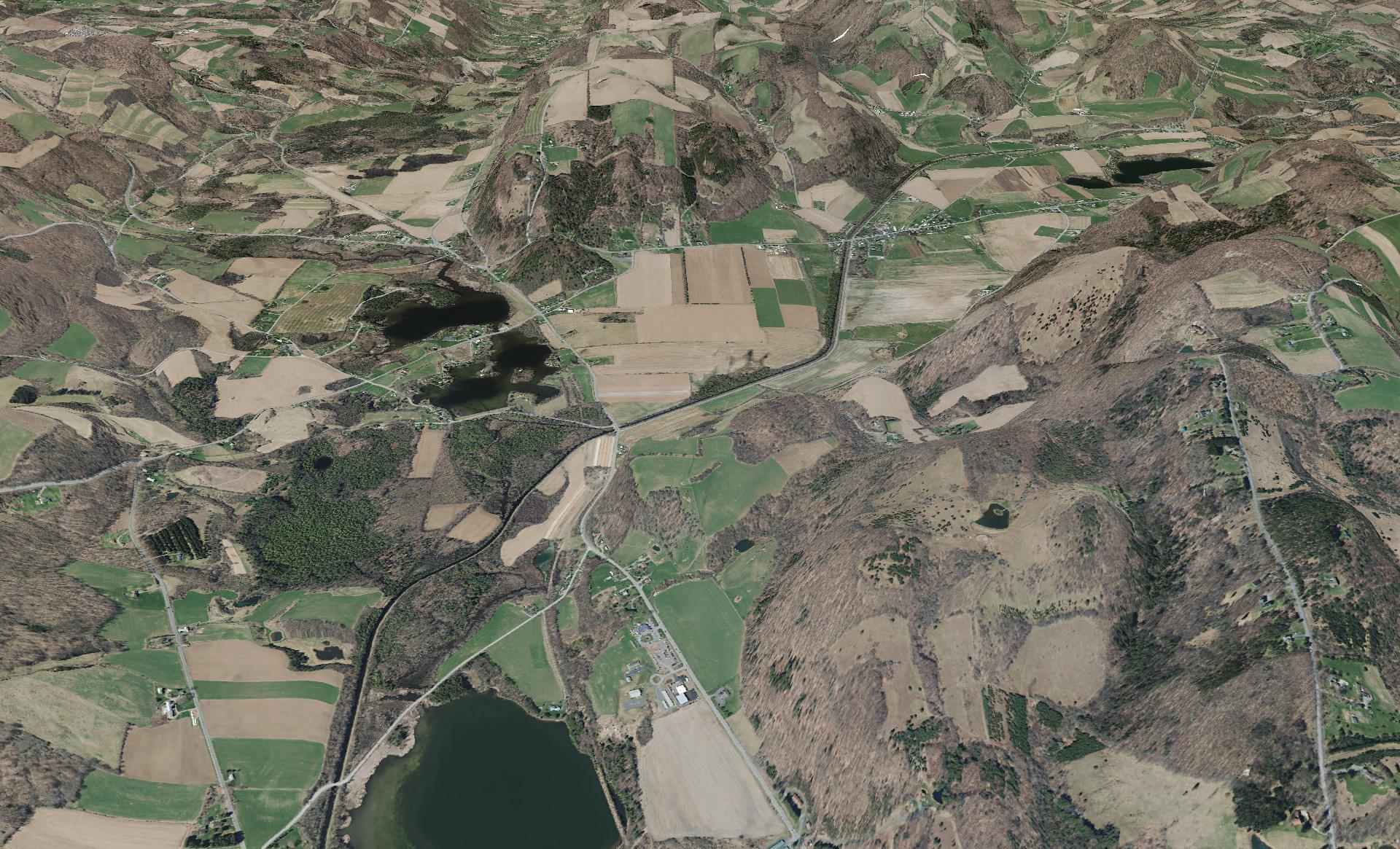
This shows a 3D rendering of the Buckville Canal north of Hamilton


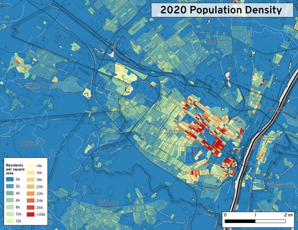
This map shows the use of 2020 PL 94-171 data to calculate population density in City of Albany.


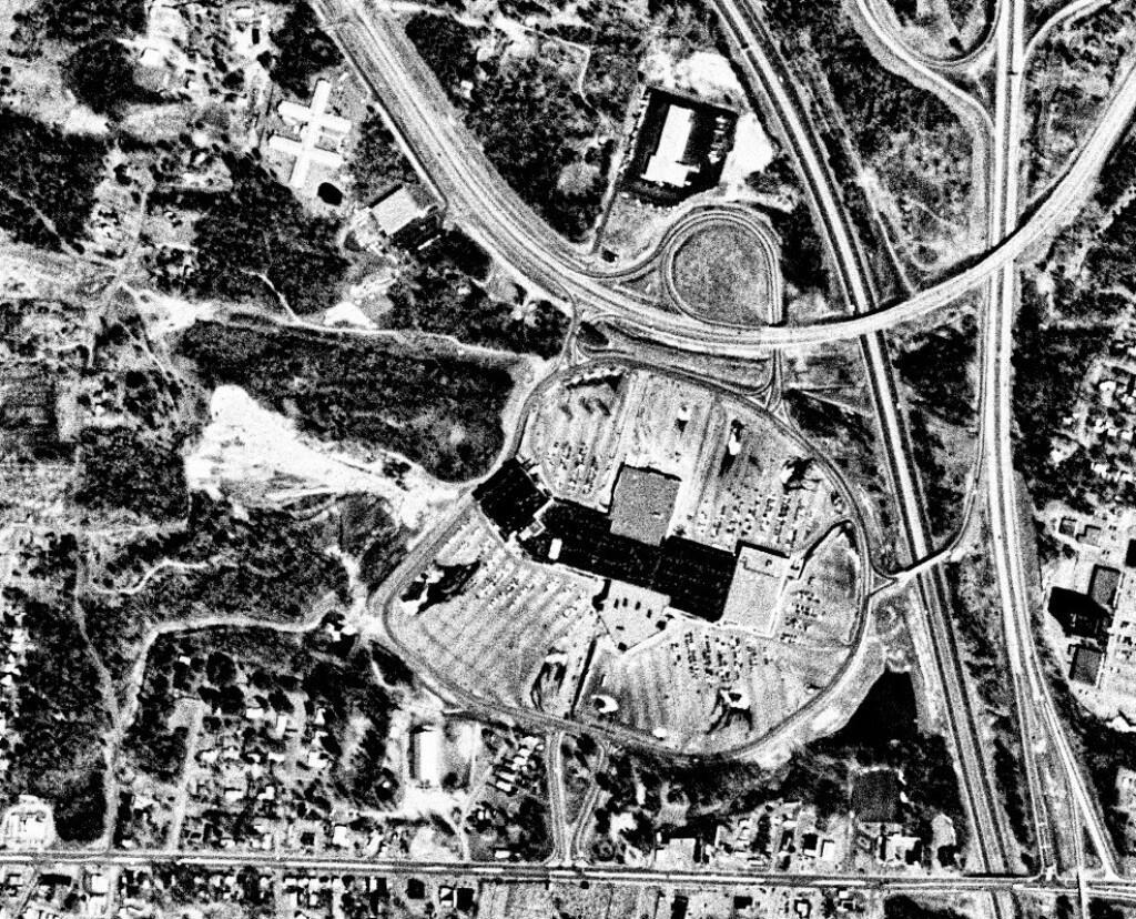
This 1985 aerial photo shows Crossgates Mall prior to it’s expansion.


This GIF image shows the change in unemployment during Coronavirus panademic.

This image shows hiking trails near Brooktrout, Falls Pond and Deep Lake.


Peebles Island, a Comparison 1952


3D Interactive of campsites at Moose River Plains.


Sample tax map in Albany.


Election results – 2020 Presidential Election, Onondoga County.


Map showing where sparklers are legally sold in New York.


Downtown Plattsburgh 1866 Beers (1866 Beers vs. 2020 OSM)


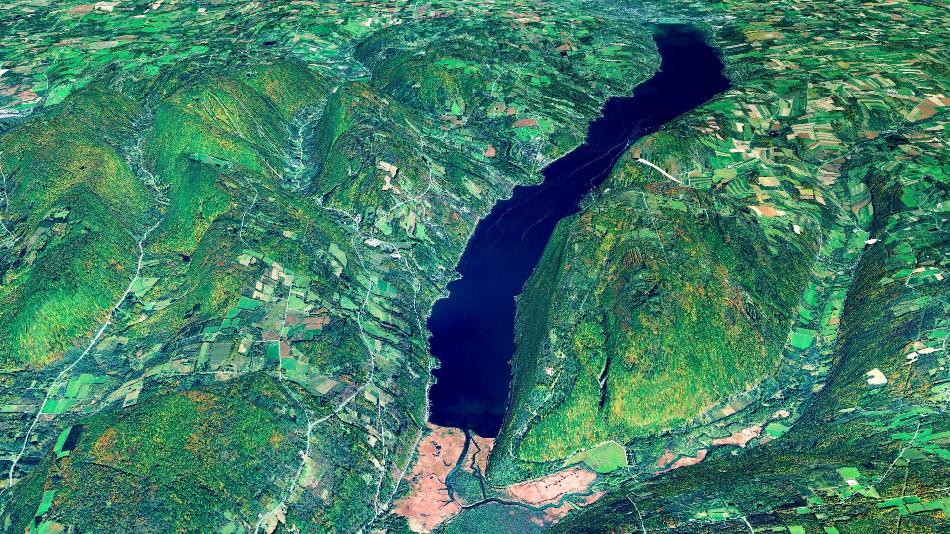
3D Rendering of Canandaigua Lake


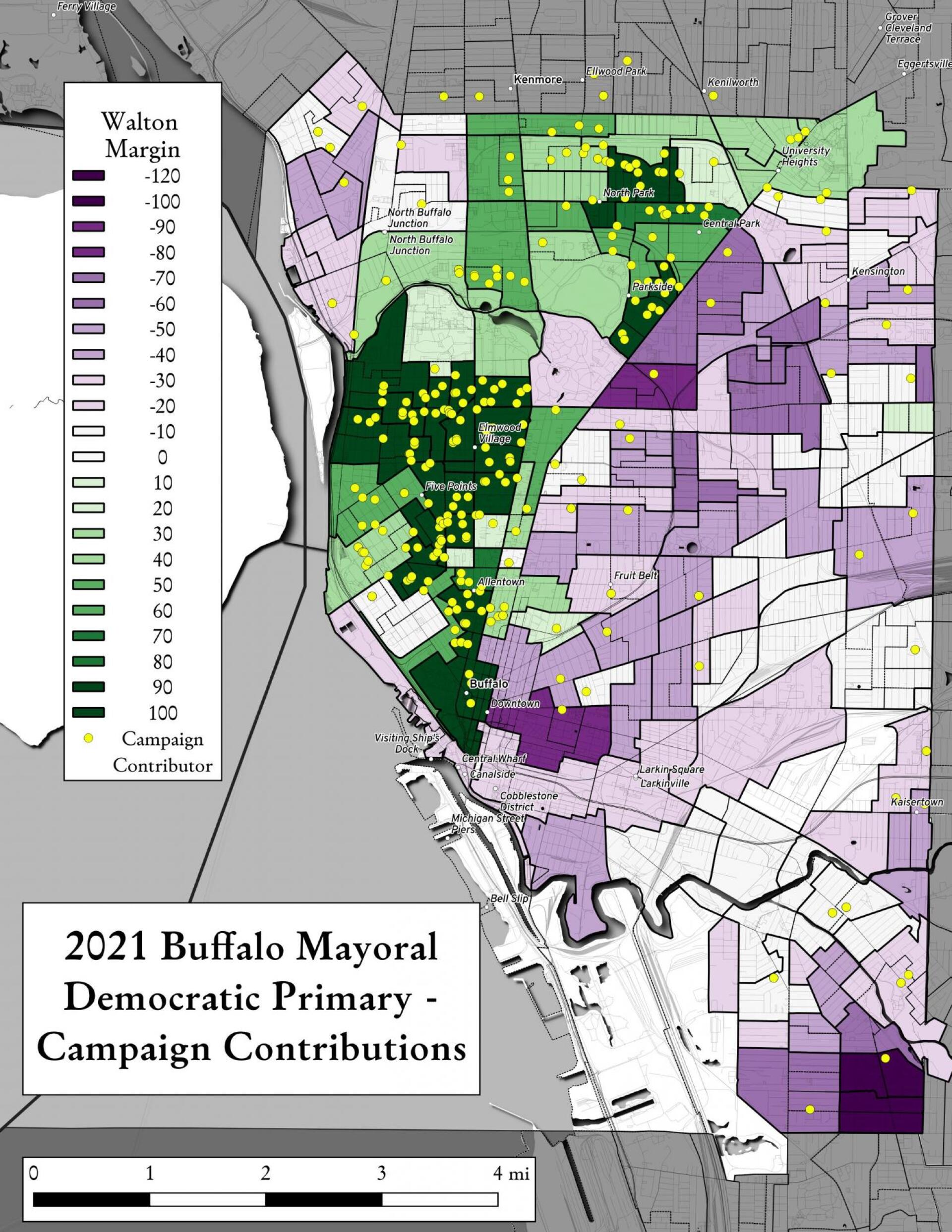
Map showing Buffalo Mayoral Primary results and campaign donors.


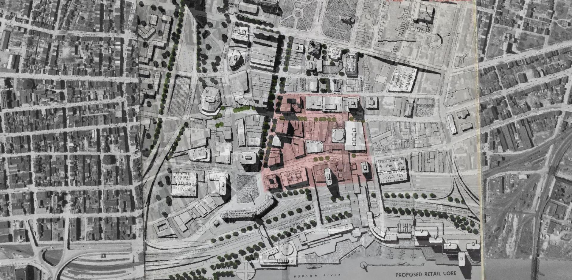
Overlay of Proposed Retail Core in 1963 Plan for the Capital City.


Map showing Local Area Unemployment Statistics – April 2020.


Interactive tax map in Delmar


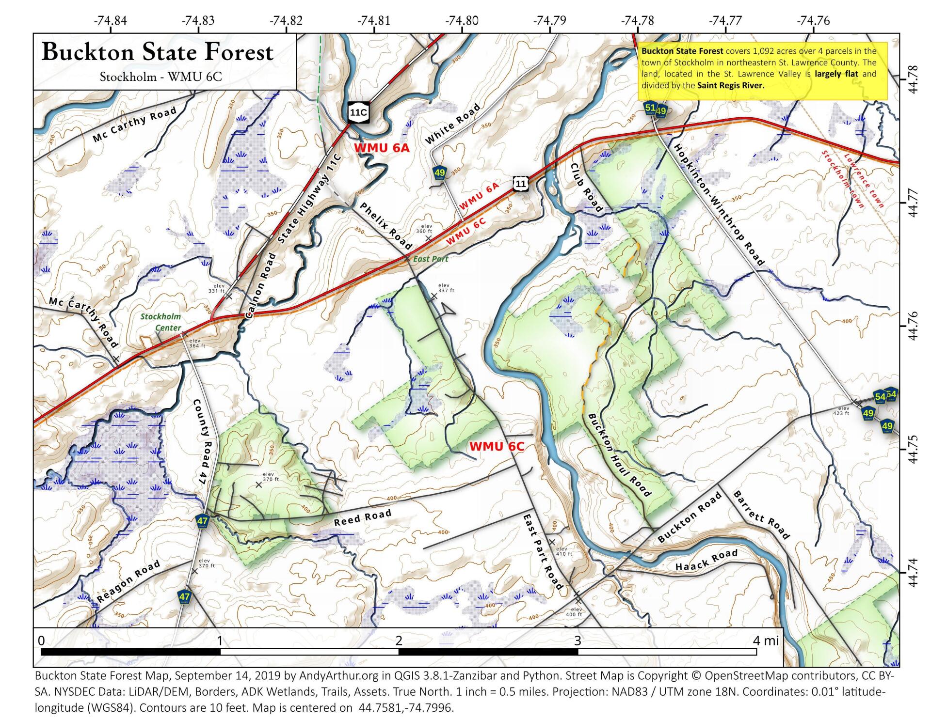
State Land in Stockholm, NY – Buckton State Forest.


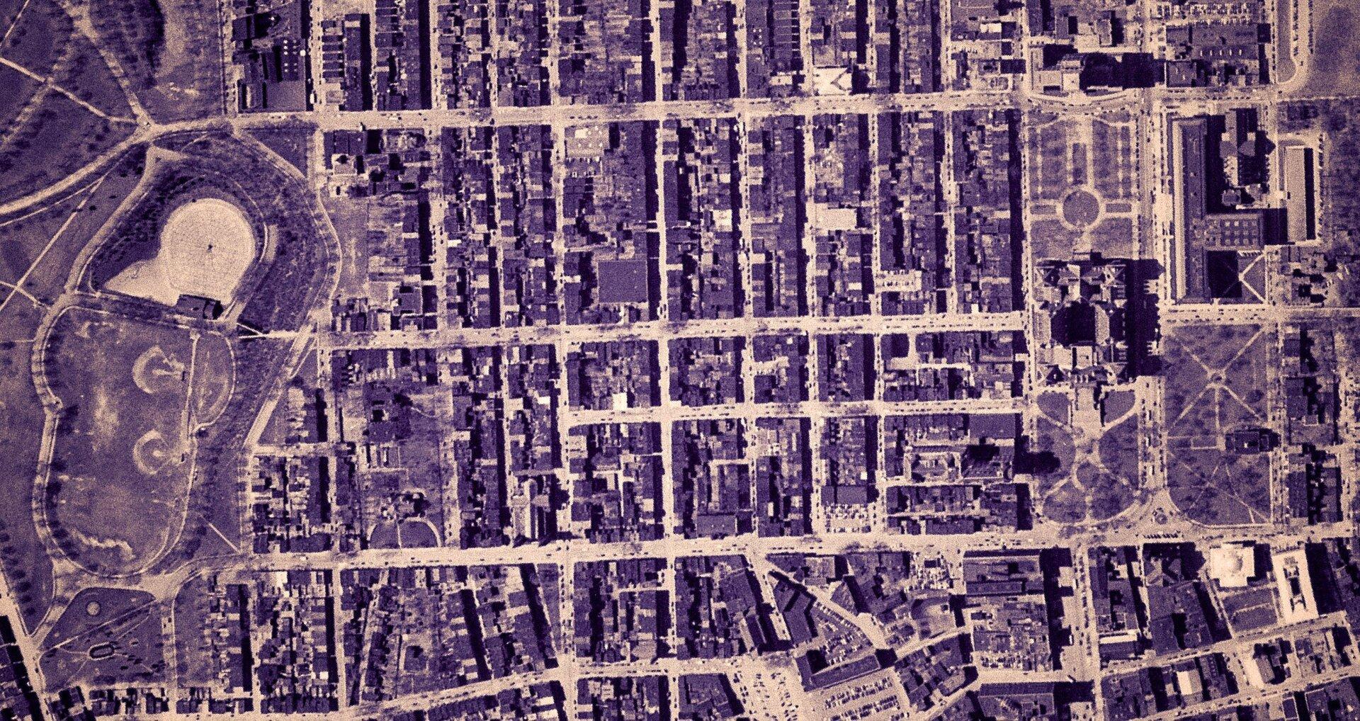
Empire State Plaza take area, 1952


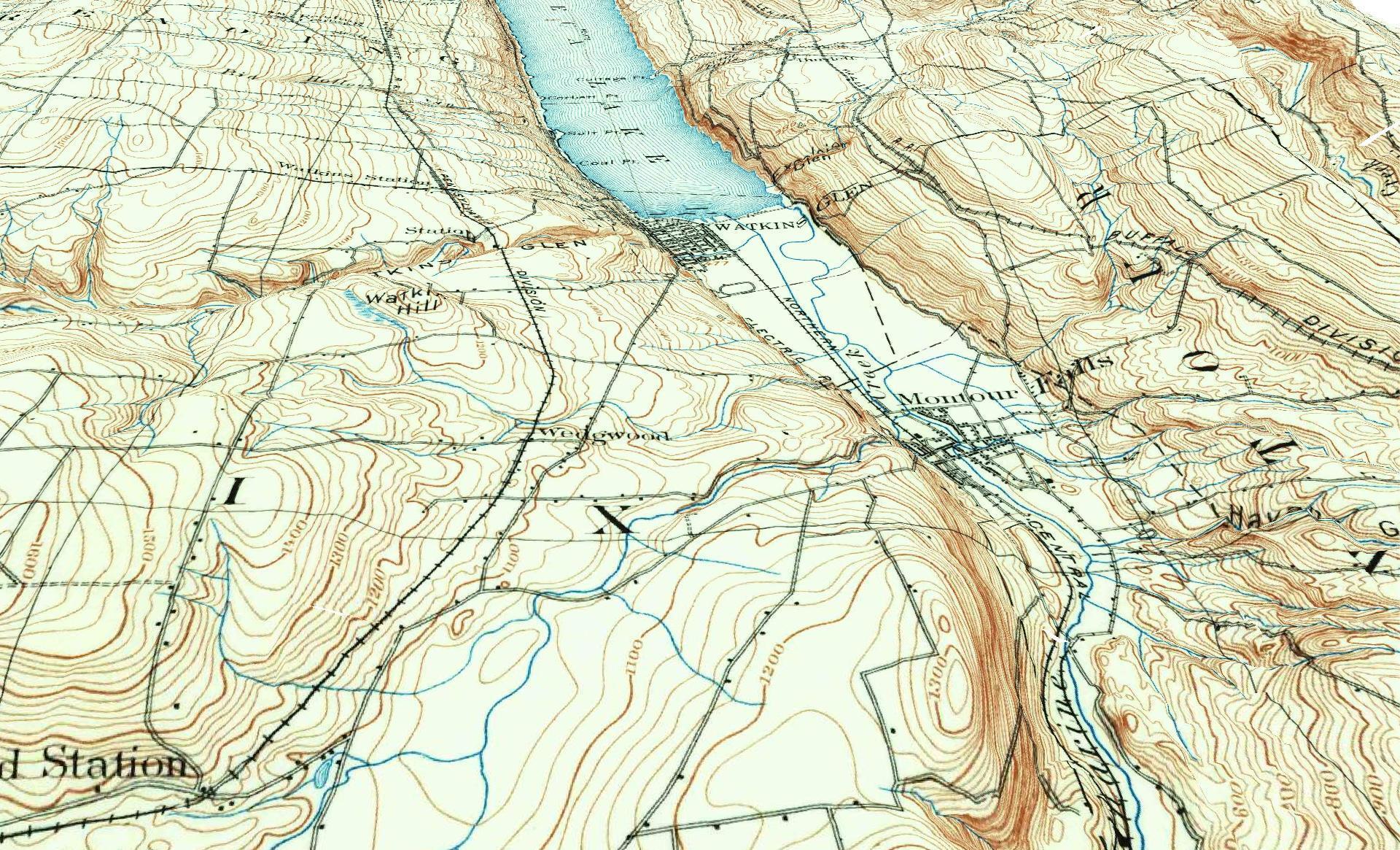
3D Rendering of the 1898 Watkins Glen Topographic Map

Examples of Data and Code

Properties in Albany Pine Bush Study Area,Excel Files: Various Tax Rolls,Find coordinates and political districts,Look Up State Tax Records and aScript for Processing RPTL 1520 PDFs.

Querying state property database, political enrollments, PL 94-171 Census files, calculating population statistics, what address is a district in, converting old districts to new districts.
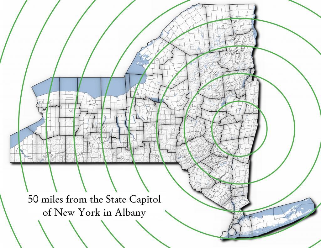
Miles from Albany millions population
50 1.002
100 1.750
150 3.511
200 17.102
250 17.725
300 18.699
350 19.411
400 20.187
450 20.201
import pandas as pd
import geopandas as gpd
 
# path to overlay shapefile
overlayshp = r'/tmp/dis_to_albany.gpkg'
 
# summary level -- 750 is tabulation block, 150 is blockgroup
# large areas over about 50 miles much faster to use bg
summaryLevel = 150
#summaryLevel = 750
 
# path to block or blockgroup file
if summaryLevel == 150:
    blockshp = r'/home/andy/Documents/GIS.Data/census.tiger/36_New_York/tl_2020_36_bg20.shp.gpkg'
else:
    blockshp = r'/home/andy/Documents/GIS.Data/census.tiger/36_New_York/tl_2020_36_tabblock20.shp.gpkg'
 
# path to PL 94-171 redistricting geoheader file
pl94171File = '/home/andy/Desktop/nygeo2020.pl'
 
# field to categorize on (such as Ward -- required!)
catField = 'Name'
 
# geo header contains 2020 census population in column 90 
# per PL 94-171 documentation, low memory chunking disabled 
# as it causes issues with the geoid column being mixed types
df=pd.read_csv(pl94171File,delimiter='|',header=None, low_memory=False )
 
# column 2 is summary level 
population=df[(df.iloc[:,2] == summaryLevel)][[9,90]]
 
# load overlay
overlay = gpd.read_file(overlayshp).to_crs(epsg='3857')
 
# shapefile of nys 2020 blocks, IMPORTANT (!) mask by output file for speed
blocks = gpd.read_file(blockshp,mask=overlay).to_crs(epsg='3857')
 
# geoid for linking to shapefile is column 9
joinedBlocks=blocks.set_index('GEOID20').join(population.set_index(9))
 
# store the size of unbroken blocks
# in case overlay lines break blocks into two
joinedBlocks['area']=joinedBlocks.area
 
# run union
unionBlocks=gpd.overlay(overlay, joinedBlocks, how='union')
 
# drop blocks outside of overlay
unionBlocks=unionBlocks.dropna(subset=[catField])
 
# create population projection when a block crosses
# an overlay line -- avoid double counting -- this isn't perfect
# as we loose a 0.15 percent due to floating point errors
unionBlocks['sublock']=unionBlocks[90]*(unionBlocks.area/unionBlocks['area'])
 
# sum blocks in category
unionBlocks=pd.DataFrame(unionBlocks.groupby(catField).sum()['sublock'])
 
# rename columns
unionBlocks=unionBlocks.rename({'sublock': '2020 Census Population'},axis=1)
 
# calculate cumulative sum as you go out each ring
unionBlocks['millions']=unionBlocks.cumsum(axis=0)['2020 Census Population']/1000000
 
# each ring is 50 miles
unionBlocks['miles']=unionBlocks.index*50
 
# output
unionBlocks

Land use in town of Berne (from 2016 National Land Cover Dataset)

Most highly assessed properties in Albany County …

from arcgis.features import FeatureLayer
lyr_url = 'https://gisservices.its.ny.gov/arcgis/rest/services/NYS_Tax_Parcel_Centroid_Points/MapServer/0'
layer = FeatureLayer(lyr_url)
query_result1 = layer.query(where="COUNTY_NAME='Albany' AND FULL_MARKET_VAL > 100000000", 
                                    out_fields='PARCEL_ADDR,CITYTOWN_NAME,FULL_MARKET_VAL,OWNER_TYPE', out_sr='4326')

df=query_result1.sdf.sort_values(by='FULL_MARKET_VAL', ascending=False)
df['Full Market Value'] = df['FULL_MARKET_VAL'].map('${:,.0f}'.format)

df
 OBJECTIDPARCEL_ADDRCITYTOWN_NAMEFULL_MARKET_VALOWNER_TYPESHAPEFull Market Value
112665264 Eagle StAlbany12042549252{β€œx”: -73.75980312511581, β€œy”: 42.650469918250…$1,204,254,925
391501200 Washington AveAlbany8862987152{β€œx”: -73.81092293494828, β€œy”: 42.679257168282…$886,298,715
4102081400 Washington AveAlbany6423982872{β€œx”: -73.82369286130952, β€œy”: 42.685845700657…$642,398,287
0885251 Fuller RdAlbany4400428272{β€œx”: -73.83559002316825, β€œy”: 42.690208093507…$440,042,827
518164632 New Scotland AveAlbany3775682018{β€œx”: -73.80381341626146, β€œy”: 42.655758957669…$377,568,201
1906141 Fuller RdAlbany3211991432{β€œx”: -73.83323986150171, β€œy”: 42.693189748928…$321,199,143
19108087See Card 1067Watervliet2808988761{β€œx”: -73.70670724174552, β€œy”: 42.719628647232…$280,898,876
1565380737 Alb Shaker RdColonie2639161003{β€œx”: -73.80365248218001, β€œy”: 42.747956678125…$263,916,100
921923304 Madison AveAlbany2342654182{β€œx”: -73.76227373289564, β€œy”: 42.648000674457…$234,265,418
2907201 Fuller RdAlbany2034261242{β€œx”: -73.83362605353057, β€œy”: 42.692609131686…$203,426,124
1669999515 Loudon RdColonie1660656008{β€œx”: -73.74958475282632, β€œy”: 42.719321807666…$166,065,600
72059247 New Scotland AveAlbany1622763388{β€œx”: -73.77597163421673, β€œy”: 42.653565689693…$162,276,338
620574132 S Lake AveAlbany1462963602{β€œx”: -73.77970918544908, β€œy”: 42.654390366929…$146,296,360
820597113 Holland AveAlbany1434985012{β€œx”: -73.77306688593143, β€œy”: 42.650762742870…$143,498,501
1778203MannsvilleColonie1425704001{β€œx”: -73.71245452369443, β€œy”: 42.718124477080…$142,570,400
18955091 Crossgates Mall RdGuilderland1305547008{β€œx”: -73.84702700595471, β€œy”: 42.687699053797…$130,554,700
102452186 S Swan StAlbany1284364032{β€œx”: -73.75980563770365, β€œy”: 42.653931892804…$128,436,403
13468831916 US 9WCoeymans1100000008{β€œx”: -73.83388475575597, β€œy”: 42.488730743021…$110,000,000
1235152380 River RdBethlehem1052631588{β€œx”: -73.76445503554325, β€œy”: 42.595925419330…$105,263,158
146509715 Wolf RdColonie1019672138{β€œx”: -73.81423716588279, β€œy”: 42.709939498581…$101,967,213
Categories:

Site Map

🌲🌲 Our Public Lands 🌳🌲

Interactive maps with backcountry and roadside camping: New York, Pennsylvania, West Virginia & Vermont.
List of NYS DEC Lean-Tos with map coordinates. List of NYS DEC Firetowers with map coordinates and more information.
Google Spreadsheet with Roadside, Primitive and Pay Campsites

Explore the Finger Lakes Trail, Long Path, Northville-Placid Trail and Long Trail/Appalachian in Vermont.
Catskill Park Mountain Peaks, Hudson Valley & Long Island Peaks, Peaks Over 3000 ft Elevation, Highest Peaks in Adirondacks, Interactive Map of All Named Summits in NYS, Blaze Colors in Catskill Park, Trailhead Parking Coordinates and Addresses in the Catskills.

Browse USGS Topo Quads as PDF πŸ†• by State Lands or County. You can Bulk Download New & Old USGS Topograpic Maps.

Links to various NY State Land Websites πŸ†•. Get latest GIS Data from state Web Services.

β›ΊπŸŒ² Camp πŸŒ²πŸ•

Moose River PlainsCampsite Listing, Maps and photos of state’s largest free camping area.
Piseco-Powley RoadCampsite Listing, Maps and photos of 15 mile dirt road with camping.
Catskill Park Primitive CampsitesAn overview of free camping locations in Catskill Park.
Burnt-Rossman Forest, Cattaraugus County, East Branch Sacandaga River, Finger Lakes National Forest, Madison County, Pennsylvania, Vermont and West Virigina.

Campsite Coordinates for Bog River Flow / Lows Lake, Hudson River SMA (Buttermilk Falls), Lake Lila, Oswegathie River, Nine-Corner Lake, Pharaoh Lake Wilderness, Saranac River Campsites, Stillwater Lake, Schoharie County, and Sugar Hill State Forest.

Overview of Camping Areas in the Catskills, Green Mountains, Southern Adirondacks, Central Adirondacks, Northern Adirondacks, Allegheny National Forest and Penna. DCNR Motorized Campsites and the Monongahela National Forest West Virginia.

Free Campsite Overview Maps: Adirondack – North Country, Catskills, Central NY, Finger Lakes, Western NY. Interactive Map.

Places I camped in 2023, 2022, 2021 and 2020.

🏞 πŸ›Ή Bicycle Trails and “Blackie” My Mountain Bike 🚲 🚢

Finally bought a mountain bike, after chewing over a mountain vs commuter bike. Really enjoying riding my bike to work and when it rains there is always a bike rack to safely take it back home. One way to get to adventures at Thacher Park is the Nature Bus.

Empire Trail – KMZ and Interactive Map. Parking along it.

More Trailways with KMZ files including the Albany County Rail Trail, Black Diamond Trail, Catharine Valley Trail, Catskill Scenic Trail, Fonda, Johnstown & Gloversville Rail Trail, Genesee Valley Trail, Link Trail.

🦌🌲 Hunt πŸ¦ƒπŸΏ

Wildlife Management Units (Deer)KMZ Map shows the WMU boundaries.

Summer 2019 Aerial Photographs of WMUs

KMZ Maps of Deer Harvest Density by Town: 2019, 2018, 2017, 2016. By WMU 2017, 2016, 2015.

KMZ Maps of Buck Harvest Density by Town: 2019, 2018, 2017, 2016. By WMU 2017, 2016

2016 -2019 Deer and Buck Harvest by TownKMZ Spreadsheet with FIPS codes for making your own calculations.

🎣🐑 Fish 🐟🐠

Parking and Access to Trout StreamsAn interactive, downloadable KMZ Map.
Lakes with DEC Contour MapsA KMZ Map links to Contour Maps for Fishing.

πŸŒ¨πŸ” Sled & Wheel πŸš™β„

State Truck Trails Over A Half MileDirt roads to explore in the backcountry.
NYS Statewide Snowmobile Trail SystemState trails on public and private lands.

πŸ“‰πŸ“Š Learn πŸ’΅πŸ“ˆ

Interactive Maps of NY CensusExplore and download KML files.
Charts and Interactive DiagramsFrom population to pollution control.
Andy Arthur GitHubGit my R and Python scripts used to make maps and diagrams.
Use ArcPullR to Get Geospatial DataSuper easy way to connect to get GIS data in R from government servers.
GDAL Opens E00 FilesMost open source programs nowadays can open common geospatial formats.
NY Building FootprintsWhere to find on the internet for making maps.
WMS and ArcMap ServicesDownloadable CSV file listing services used on the blog.
2022 US Census Population EstimatesRed states, south continue to gain population.
2020 Cartogram of State Population

πŸ’³ πŸ› Property Taxes πŸ πŸ’Έ

Properties in Albany Pine Bush Study Area, Excel Files: Various Tax Rolls, Find coordinates and political districts, Look Up State Tax Records and a Script for Processing RPTL 1520 PDFs. Match NY SWIS Codes to FIPS Codes and GEOID

πŸš—πŸš— Big Red πŸš—πŸš—

Big RedPhotos and Videos of my lifted truck with its camper shell. Big Red’s Dual Battery Setup for Camp Power, Video Tour and Diagram. Big Red is getting old. What is next? I’ve thought about going carless for a while to save money and reduce pollution. Or maybe going bigger? Or smaller? Five dollar gas sucks.

πŸ”₯🌲 Off-Grid Living 🏠🀠

I am seriously thinking about building an off-grid house. I have a first draft. I need to learn CAD! I have a road map towards buying land and building. I concede might have to live with long commute and give up traveling and camping. I need to be strong.

Why off grid? Well, I’m not into contemporary society. I want to own land, but not be called a landowner, and a cabin, not hooked to electrical grid, farm, raise pigs for food and burn my own trash. I’m saving for a better tomorrow, hoping to make the leap to another freer state. Having acreage is important. Cornfields aren’t bad neighbors. Maybe though my vision has grown smaller and more local. More on off-grid living.

I am 16 years into my career and have made some significant progress in my life. I love my job. But I do wonder on all the things I’m missing out but saving sure makes me high. Maybe it will be different when I own my own land — the end of goal of all this saving.

2020 into 2021 during the pandemic was a year of remote work. It was a struggle not having internet at home, worked a lot out of my truck. But I worked remotely from Horseshoe Lake which was super cool.

Generally I like the idea of owning land in a red state, particularly Idaho, Iowa, Pennsylvania, West Virginia, Wisconsin — and Midwest more generally. But I may settle for New York – it’s all about the f-ing money!

πŸ’»πŸ‘¨β€πŸ’» Open Source πŸ—ΊοΈπŸ“

I use open source software and public sources of data for the blog. Quantum GIS (QGIS), GDAL/ogr2ogr, PyQGIS, GeoPANDAS, R Studio and Leaflet for map making, Arduino and ESP32 microprocessors, Ubuntu Linux and XFCE Window Manager. I’ve recently gotten interested in machine learning.

I avoid using commercial software like Microsoft Windows and do not have home internet or television. If you don’t use commercial software and use your brain, fears of computer viruses are overblown. I deleted most of my social media accounts.

Creating Digital Surface Models using LiDAR Point Clouds.

πŸ“ŠπŸ—Ί R Statistical Programming πŸ“œπŸ‘¨β€πŸ«

The R programming language and RStudio are powerful tools for statistical analysis, making maps and charts. Many of the blog posts and analysis I do are in R, ggplot not only makes great charts but also maps using tidycensus. Generally, R is better then Python for geospatial work.

Use IDW Interpolation to fill in missing Census data, Zonal Histograms for land cover, load WMS Aerial Photography in R, find mountain peaks, save Census shapefiles using tigris quickly, pull NY Election Night Results using Selenium. Fast reverse Geocoding in PostGIS. Working with PDFs in R. Fix a common error starting rselenium/wdman. Make data-filled calendars. R is wonderful and weird, learn it!

πŸΌπŸ”’ Python and Pandas πŸ’»πŸ

Querying state property database, political enrollments, PL 94-171 Census files, calculating population statistics, what address is a district in, converting old districts to new districts, Shapefiles missing Projection information in QGIS.

Learn to code for free modern HTML, Javascript, Python and SQL at freeCodeCamp and web development at the Odin Project.

🐴 🐘 Politics 🦁 🐍

Crunched Election Results with Turnout for Albany County: November 2023, 2022, 2021, 2020, 2019 and Primaries June 2019, Pres/June 2020, June 2021, June 2022, Aug 2022, June 2023.

Albany County Races converted to the new 2023 EDs using Super EDs and Code: 2022, 2021, 2020, 2019 and Primaries June 2019, Pres/June 2020, June 2021, June 2022, Aug 2022.

Above Election Results as zipped Excel files.

Albany County Legislature Districts 2024 Maps

Maps Comparing 2017 and 2023 Albany County Election Districts and a Crosswalk Table Showing the Proposition of Voting Age Population in New and Old EDs

Maps of 2022 NYC Assembly Races, NYS Assembly Races, NY Senate Races, Governor’s Race in Erie County and Statewide. Partisan shift in governor race between 2010 and 2018.

A comparison of Democratic Performance 2022 Assembly Districts to those proposed in 2023 by the IRC. Here is latest 4/20/23 IRC Maps, showing ADP and how they change from existing Assembly districts. Most towns upstate, outside of cities, are quite red. Using LATFOR data with R to calculate Average Democratic Performance.

You can scrape employee salary data from SeeThroughNY using R. Other useful investigative resources.

I often think politics is for losers. I’m into the politics of statistical analysis and reading history books.

I believe strongly in the first amendment, second amendment, oppose gun restrictions and I support de-funding the police in favor of lower-cost technology and civilian employees. Maybe use red flag laws for voting to stop dangerous voters? And the media should stop promoting mass-shootings, even if it’s super profitable for all involved. They should tax the media when it promotes violence. I think some people are much too paranoid in politics. How elections are rigged under law to benefit incumbents. But vote, it’s the best option and inexpensive.

Yeah for the third parties! I voted for Larry Sharpe for Governor and Jo Jergenson for President but my views are complicated and often vote for Democrats, after voting Jill Stein Green Party in 2016.

Generally, I think Biden has been a good change over DJT and glad the Trump era is over and are glad prosecutors and grand jurors are holding him responsible by indicting him for many serious felonies. I don’t think Trump can win in 2024, as nothing has changed politically from 2020.

I think rural people should be left alone and not worship government workers or have parades for them. I am no fan of Donald Trump, his speeches are bad, I don’t like Trump’s embrace of radical environmentalists, but do admire the homemade roadside monuments to DJT.

I don’t toke. But whatever. There are too many transit authorities.

🌲🌳The Earth 🌎 🐸

Why I oppose wilderness areas and parks. It’s trendy to be green these days, but is eco-marketing good for the planet? I visited the Mount Storm Coal Plant and Corridor H.

I worry about a lot about overly-aggressive Climate Change Action, and Undermining Environment Laws for Climate Action. I think we should all admit we are Addicted to Fossil Fuels. These days, urban recycling has become a joke, when it’s still an option at all. It’s better to just buy less shit and avoid the alure of Costcos. I really don’t like how aging radicals have become industrial solar salespeople.

Big bucks are coming to state-designated disadvantaged communities under the CLCP. Which counties and political districts are in line for the the most pork? Interactive map.

I’m a big of farmers who are essentially Living Off the Earth and think Rednecks are Noble Savages. Dairy Farming are key to our rural landscape. I’d trust a farmer or a hunter in a pile of guts he’s butchered over any ivory-tower scientist.

πŸŒŽπŸ”† Industrial Solar 🌞 🏭

Hundreds of multi-acre industrial solar farms are being built in our state. How bad is solar for the environment? We should ask tough questions. Interactive of recently built solar farms, proposed facilities. List of proposed industrial solar facilities. See how the Greenville Solar Farm changed the landscape.

πŸ’³ πŸ’ΈSaving Money πŸ’° πŸ’·

I am not a fan of ESG Investing as it’s not well diversified. I prefer index-funds and other tax-advantaged ways of saving. Why I am concerned about saving enough for retirement, even though I’m in my late 30s. We as a nation should save more, consume less. I like the idea of carbon tax to replace capital gains taxes to discourage consumption.

πŸ₯¦ 🍎Mission Fifty & Being Healthier 🏠🧠

I am now officially in my 40s! I am building to a better life in my 50s, which means getting up early, walking a lot, saying no to cake and yes to more fruit. In many ways, the forties are an awesome time to be alive.

And eating healthy for less without losing sleep over arsenic. And I don’t think we should subsidize unhealthy habits. How I got started in eating healther. Meals are too focused on meat and carbs due to how we describe them, maybe I eat too many bananas in the office, what to eat while camping, worry more about salt then GMOs, eat more beans. Do spend extra for farmers market peaches, especially doughnut peaches and plums. Consider ethnic supermarkets. Thinking about how to make a healthier macaroni and cheese, spinach-mackeral-pasta salad, quick-cook biscuits and whole-wheat bread. That said, too many recipes are junk food crap. Okay in moderation is not okay. The fact that I’m thinner is not a sign I’m dying.

A few years back I decided to explore my mental illness with therapy, thinking about why I have so much anxiety and how many of my values are rational or just thinking too much rednecks’ burn barrels and how much of a throwaway society we live in. Do I want to change?

I’ve learned to care less about the world, and focus more on myself. Maybe I am happier as I am now, saving and investing a lot towards owning my own land, where I don’t have to deal with all the bullshit of modern life.

Mission Fifty: Getting to the point where I own my own land. 🚜
Healthy Eating 🍎 / Growing My Wealth πŸ’°
Healthy Thoughts πŸ’­ / Enjoying Life πŸ˜ƒ

Questions, comments? Feel free to email me at andy@andyarthur.org.

You do your thing, I’ll do mine.

I use GNU open source software.
Plus I like buck goats,
because they’re real macho men
spraying their beards with goat urine.

We made it to spring time. I bet the black flies and cows are super excited about that.” – Andy Arthur

Return to the Top

Laugh a bit and learn how your data is used on this blog: Privacy Policy

This blog is Β© Copyright 1997-2023 Andy Arthur.org, please share using the Creative Commons Attribution 3.0 License.

Categories:

August 12, 2020 Evening

Good evening! Mostly clear and 73 degrees at the Finger Lakes National Forest. There is a north breeze at 6 mph. πŸƒ. The dew point is 53 degrees. A very nice evening, might even want a long sleeved shirt πŸ‘š by morning. No fan tonight for me in the truck cap. ☒️

I did everything that I planned today without feeling rushed. 😊 I too often feel like I am running πŸƒ from park to park 🏞 on vacation and not taking time to relax. But this year with the pandemic smoldering in the background and an otherwise busy season with work I’ve been taking it slow and doing a lot of reading πŸ“– and relaxing πŸ› while still enjoying the Finger Lakes. I’ve limited the number of parks I plan to visit and are staying at the same campsite β›Ί with no cell service πŸ”• all eight nights to avoid set up and take down. After vacation, work is going to be non-stop as a supervisor, and I’ll be on call πŸ“ž virtually all the time through November.

Caywood Point was interesting to explore on Seneca Lake. πŸ›₯ I bet it’s fun to camp dorm there on a very starry night. πŸŒƒ Some folks had tents pitched right on the shoreline – I guess you don’t have to worry about the tide on a Finger Lake. Seemed like an interesting group of people who hang out there. I should think about going back there and do some fishing 🎣 off the dock or go for a swim πŸŠπŸ»β€β™‚οΈ there.

I hiked part of the Catherine Valley Rail Trail πŸš‚ through the Catherine Marsh WMA aka Bad Indian Swamp. 🌿I am sure the later is disfavored as a name, with the preference today recalling Seneca Chief Catherine Montour, although to this day there are towns that recall the first and last name, so the natives are hardly forgotten. πŸΈπŸ¦†πŸ•ŠοΈπŸŒπŸπŸ’ And I doubt the old name was referring to a Bad Indian, just that it was a large, thick area that was marshy and filled with reeds and difficult to pass until the Barge Canal and later the railroad tracks and NY 14 on the east shore. 🌾The swamp is largely reeds, probably the best views from the rail trail are of the Barge Canal. At least from the trail it didn’t stink of sewage. πŸ’©

Then I went for a quick swim πŸŠπŸ»β€β™‚οΈ at Watkins Glen State Park. Nobody was manning the toll booth so I didn’t have to show my Empire Passport πŸ›‚. But the pool was open and mostly empty and lead to a nice cool way to break up the evening and cool down.

I went to Tops and stocked up on some food. πŸ₯© I bought some boneless chicken which I realized at camp was actually pork chops. πŸ– I have nothing against pork, it was good with the rice I bought, stuck in a nice hamburger role, washed down and with some beer 🍻. I also stopped at Glen Dairy Bar and got a large dish of soft ice cream 🍧 dipped in peanut butter πŸ₯œ. That was good.

Then before dark I went kayaking πŸ›Ά from the Watkins Glen boat launch. I was going to paddle up to Hector Point but on the way up there I was warned by another kayaker that the water was choppy once you got beyond the bend, and after paddling a few more minutes agreed it seems a bit rough and didn’t want to get caught on open water and ended up just paddling along the south end of the lake by Clute Park. 🎣 Had my fishing pole but the lake was so rough and the south end of the lake so shallow I decided it wasn’t worth it.

Got back to camp around eight, πŸ•οΈ cooked up the pork chops πŸ₯© and rice 🍚 had dinner and started a fire πŸ”₯ and laid back in the hammock. I forgot to buy coffee β˜• today, I’ll have to get some tomorrow. Ice is not holding up well in the heat 🌑️, I may need to get more at any rate tomorrow and can get coffee at the same time.

Tonight will be mostly clear πŸŒƒ, with a low of 59 degrees at 3am. Two degrees below normal, which is similar to a typical night around August 21st. Maximum dew point of 54 at 10pm. North wind 3 to 6 mph. In 2019, we had cloudy skies in the evening, which became light rain by the early hours of the morning. It was sticky. It got down to 67 degrees. The record low of 43 occurred back in 1957.

Tonight will have a Last Quarter πŸŒ— Moon with 37% illuminated. The Strugeon 🐑 Moon is on Wednesday, August 26. The darkest hour is at 1:13 am, followed by dawn at 5:42 am, and sun starting to rise at 6:12 am in the east-northeast (69Β°) and last for 3 minutes and 5 seconds. Sunrise is one minute and 3 seconds later than yesterday. πŸŒ„ The golden hour ends at 6:51 am with sun in the east-northeast (75Β°). Tonight will have 10 hours of darkness, an increase of 2 minutes and 28 seconds over last night.

Tomorrow will be mostly sunny 🌞, with a high of 82 degrees at 3pm. One degree above normal, which is similar to a typical day around August 9th. Maximum dew point of 57 at 5pm. Calm wind becoming northeast around 6 mph in the afternoon. A year ago, we had mostly sunny skies in the morning, which became cloudy by afternoon. It was somewhat humid. The high last year was 81 degrees. The record high of 98 was set in 1947.

While I’m not totally sure and left the kayak on my truck, I am thinking tomorrow would be a good day for hiking. 🚢🏽 I am thinking about the Dresden – Penn Yann rail trail as I’ve never explored that part of the Finger Lakes and that was recommended to me on Facebook. Apparently this trail follows the old railroad grade in the gorge along the Penn Yann outlet. 🏞 Sounds intreguing in my book but I should read up on it before making the trip in the morning.

I’ve been having a few problems uploading photos πŸ“Έ today, there was a glitch in my new phone uploader that I built but I think it’s working now. I still have to upload photos from kayaking πŸ›Ά this evening on Seneca Lake but that will have to wait until tomorrow when I have better cell service πŸ“Ά.

I was saddened to hear about the passing of Reszin Adams, πŸ˜” who has been called the alpha activist of Albany. Not only did she bake lasagna for every Pine Bush Dinner for 35 plus years, she was involved in everything from protesting the Vietnam War to Aprahid in South Africa.

I don’t know where things stand with the documentary πŸ“Ή I was working with Cynthia Pooler on her – we cut some n roll at her birthday party πŸŽ‚ in February but when she pandemic hit everything kind of stopped except for video editing. I barely know how to use the camera but we did interview several people om Reszin. Definitely sad news for everybody in the Capital Region that cared about progress and change.

At least I got to know her a little bit more than Theresa Cooke, πŸ‘©πŸΌ the lady who confronted Erastus Corning and made a big difference in openness and change in the Albany County Democratic Machine.🐴 I had met Cooke at Pine Bush dinners in her late years but never knew the difference she made in the 1970s. She just struck me as some kind of activist but I never asked any questions until I learned about her history upon her death.

In four weeks on September 9 the sun will be setting in the west (277Β°) at 7:27 pm,πŸŒ„ which is 45 minutes and 25 seconds earlier then today. In 2019 on that day, we had mostly sunny, patches of fog and temperatures between 73 and 49 degrees. Typically, you have temperatures between 75 and 54 degrees. The record high of 94 degrees was set back in 1959.

Looking ahead, National Dog Day 🐩 is in 2 weeks, Corn Moon πŸŒ• is in 3 weeks, SORRY NO NOT NATIONAL CORN DOG DAY, Columbus Day πŸ›₯️ is in 2 months, Average High is 55 πŸ‚ is in 11 weeks, Day After Election Day πŸ›€ is in 12 weeks, Veterans Day πŸ‡ΊπŸ‡Έ is in 13 weeks, Earliest Sunset of the Year βŒ›οΈ is in 17 weeks, Tea Party Day 🐍 is in 18 weeks, Festivus πŸ– is in 19 weeks, Bacon Day πŸ₯“ is in 20 weeks, Make Your Dream Come True Day 🏑 is in 22 weeks, Inauguration Day βœ… is in 23 weeks, Clean Your Computer Day 🧹 is in 26 weeks and Presidents Day πŸ‘΄ is in 27 weeks.

Clouds Hanging Low