First Day Of Summer At Camp
The first three days of my working trip, I spent camping at Mason Lake, not right at the lake, but at one of the campsites down along the way.
Taken on Saturday June 20, 2020 at Mason Lake.
The first three days of my working trip, I spent camping at Mason Lake, not right at the lake, but at one of the campsites down along the way.
Taken on Saturday June 20, 2020 at Mason Lake.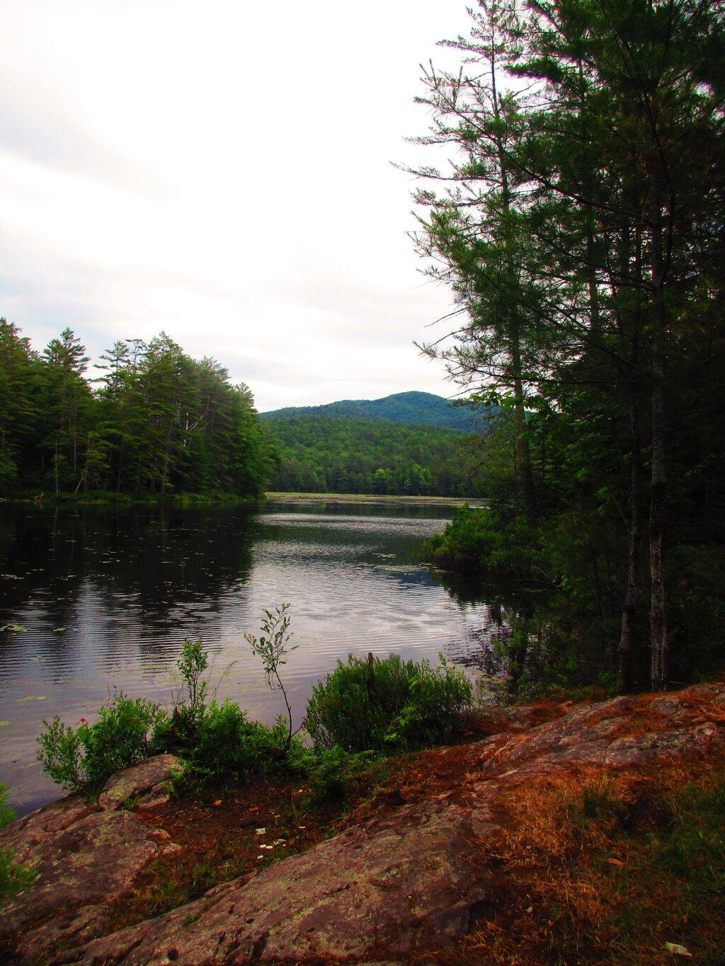
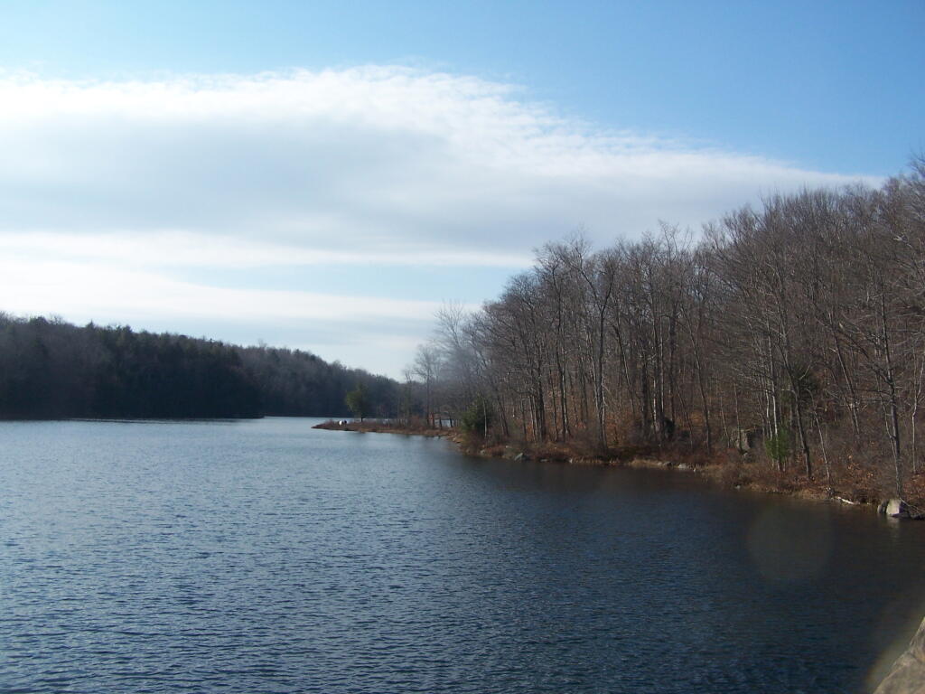
This is the view from the campsite at the end of Hammond Pond. There is supposedly a trail along the south end of the lake, which follows an old woods road,but I did not stick around long enough to fully explore it.
Taken on Saturday June 27, 2020 at Hammond Pond.
|
Name |
Asset |
Latitude |
Longitude |
|
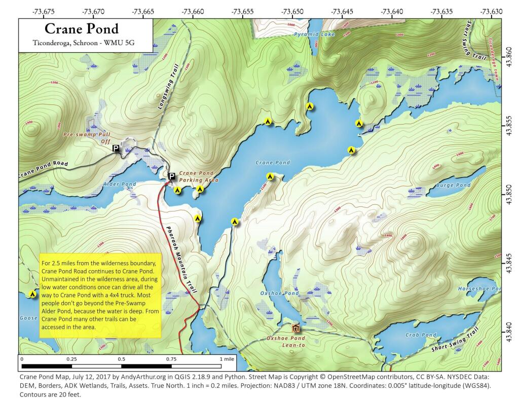
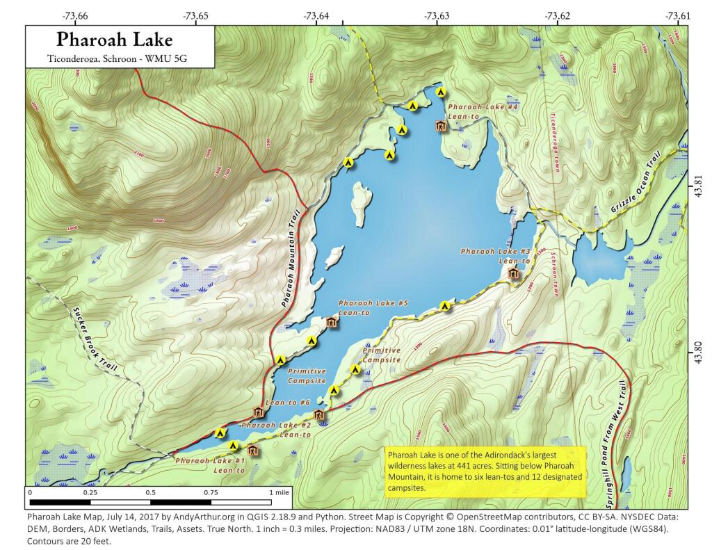
Pharaoh Lake #6 Lean-To |
Lean-To |
43.7968645799076 |
-73.6453393000723 |
|
Pharaoh Lake #1 Lean-To |
Lean-To |
43.7945783124509 |
-73.6458567829525 |
|
Pharaoh Lake #2 Lean-To |
Lean-To |
43.7966550549719 |
-73.6403349621639 |
|
Pharaoh Lake #5 Lean-To |
Lean-To |
43.8021964675395 |
-73.6391689121333 |
|
Pharaoh Lake #3 Lean-To |
Lean-To |
43.8049450667974 |
-73.624008537146 |
|
Pharaoh Lake #4 Lean-To |
Lean-To |
43.8138781587361 |
-73.6298196296567 |
|
Grizzle Ocean Lean-To |
Lean-To |
43.8223693680754 |
-73.5906397884625 |
|
Berrymill Pond Lean-To |
Lean-To |
43.8145480146987 |
-73.5808194788279 |
|
Clear Pond Lean-To |
Lean-To |
43.8384100123378 |
-73.5916749096727 |
|
Lillypad Pond Lean-To |
Lean-To |
43.8492027144111 |
-73.6180024104682 |
|
Little Rock Pond Lean-To |
Lean-To |
43.8500028765659 |
-73.5895397841294 |
|
Rock Pond Lean-To |
Lean-To |
43.8505590668051 |
-73.592294909266 |
|
Tubmill Marsh Lean-To |
Lean-To |
43.8581713274059 |
-73.6264837116145 |
|
Oxshoe Pond Lean-To |
Lean-To |
43.8405296775845 |
-73.6501782299231 |
|
Primitive Campsite |
Primitive Tent Site |
43.7948836587562 |
-73.6474883666327 |
|
Primitive Campsite |
Primitive Tent Site |
43.7999648334882 |
-73.6434422391773 |
|
|
Primitive Tent Site |
43.8010952837628 |
-73.6408309573217 |
|
|
Primitive Tent Site |
43.8117705334837 |
-73.6375426391986 |
|
|
Primitive Tent Site |
43.8121707849735 |
-73.6341143149531 |
|
|
Primitive Tent Site |
43.8136706560322 |
-73.633048112762 |
|
|
Primitive Tent Site |
43.8030516237735 |
-73.6297348572877 |
|
|
Primitive Tent Site |
43.8193354996829 |
-73.65747804896 |
|
|
Primitive Tent Site |
43.8556083933363 |
-73.6526454340756 |
|
|
Primitive Tent Site |
43.8553560492636 |
-73.6434934209565 |
|
|
Primitive Tent Site |
43.853420940198 |
-73.6443087043536 |
|
|
Primitive Tent Site |
43.8516091992566 |
-73.6525115349884 |
|
|
Primitive Tent Site |
43.8483564865511 |
-73.6561304820428 |
|
|
Primitive Tent Site |
43.8486433463009 |
-73.6598563784851 |
|
|
Primitive Tent Site |
43.850773876634 |
-73.6595722738751 |
|
|
Primitive Tent Site |
43.8507194001727 |
-73.6618378580291 |
|
|
Primitive Tent Site |
43.8331021423051 |
-73.7097323540105 |
|
|
Primitive Tent Site |
43.8124799577657 |
-73.7050524609 |
|
|
Primitive Tent Site |
43.7747284324473 |
-73.6589052716234 |
|
|
Primitive Tent Site |
43.7956403917561 |
-73.6485369956501 |
|
|
Primitive Tent Site |
43.7885754431502 |
-73.5936825866447 |
|
|
Primitive Tent Site |
43.7885154200448 |
-73.5981036241442 |
|
|
Primitive Tent Site |
43.8266003548121 |
-73.5455675180987 |
|
Mill Brook Site #2 |
Primitive Tent Site |
43.7731745678092 |
-73.6873067700498 |
|
Mill Brook Site #1 |
Primitive Tent Site |
43.7741611592771 |
-73.6880013816841 |
|
|
Primitive Tent Site |
43.8566601341087 |
-73.6484122890764 |
|
|
Primitive Tent Site |
43.8151061584018 |
-73.6321296287074 |
|
|
Primitive Tent Site |
43.8159091584052 |
-73.6297756291354 |
|
Primitive Campsite |
Primitive Tent Site |
43.7981027995837 |
-73.639049610409 |
|
Primitive Campsite |
Primitive Tent Site |
43.7993326475457 |
-73.637242399798 |
|
|
Primitive Tent Site |
43.8435148029027 |
-73.6820672971608 |
|
|
Primitive Tent Site |
43.8433169752042 |
-73.6795131679241 |
|
|
Primitive Tent Site |
43.8433308551291 |
-73.676555649628 |
|
|
Primitive Tent Site |
43.8272204500655 |
-73.5436849973277 |
|
|
Primitive Tent Site |
43.8225268634159 |
-73.5417697318413 |

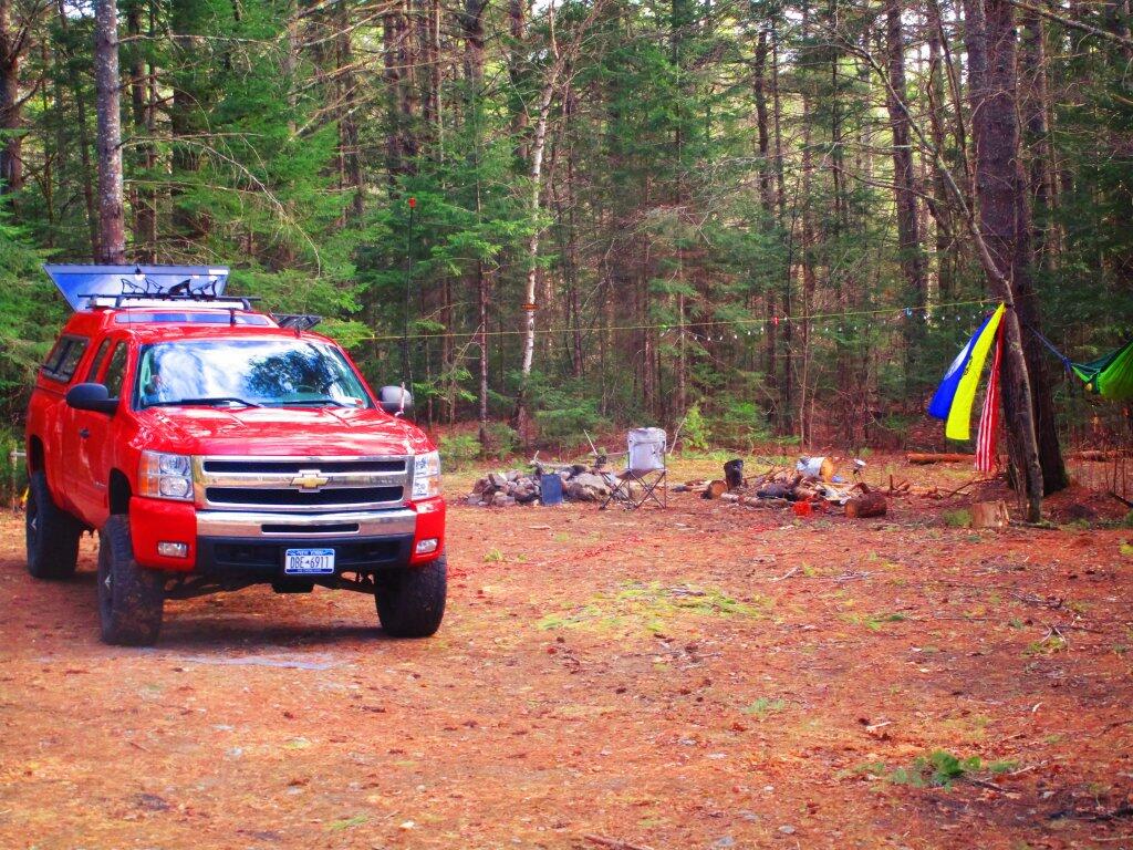
This past weekend I camped once again at Campsite 5. I knew this campsite wouldn't be too muddy, it was protected from the wind and some of the road noise, plus there was that great big pile of firewood.
Taken on Saturday May 2, 2020 at East Branch Sacandaga River.Here is a printable PDF map of Nine Corner Lakes.
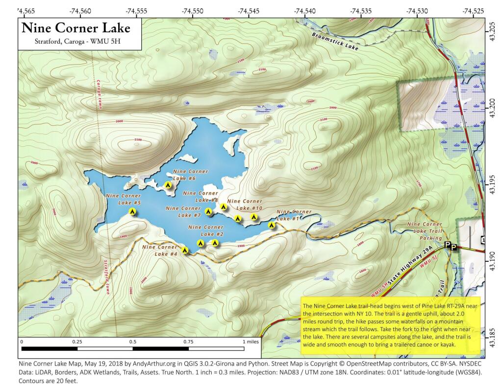
Here is a list of coordinates of the ten campsites on Nine Corner Lakes.
| Name | Latitude | Longitude |
| Campsite 1 | 43.1924389371481 | -74.5430762618629 |
| Campsite 2 | 43.1913078793683 | -74.5481281244049 |
| Campsite 3 | 43.1912867989861 | -74.5494095257902 |
| Campsite 4 | 43.1908352130274 | -74.5508138254729 |
| Campsite 5 | 43.1933896003805 | -74.5554635953599 |
| Campsite 6 | 43.1951031544948 | -74.5522807361007 |
| Campsite 7 | 43.1933585199337 | -74.5486993715471 |
| Campsite 8 | 43.1936621808895 | -74.5473488389736 |
| Campsite 9 | 43.1928875696147 | -74.5460840377464 |
| Campsite 10 | 43.1929919401202 | -74.5446495634989 |
Exploring Lost Pond at the Charles Baker State Forest off Truck Trail 4. There is a drive in campsite designated at the trailhead with a camp here logo.
Taken on Monday January 16, 2023 at Charles Baker State Forest.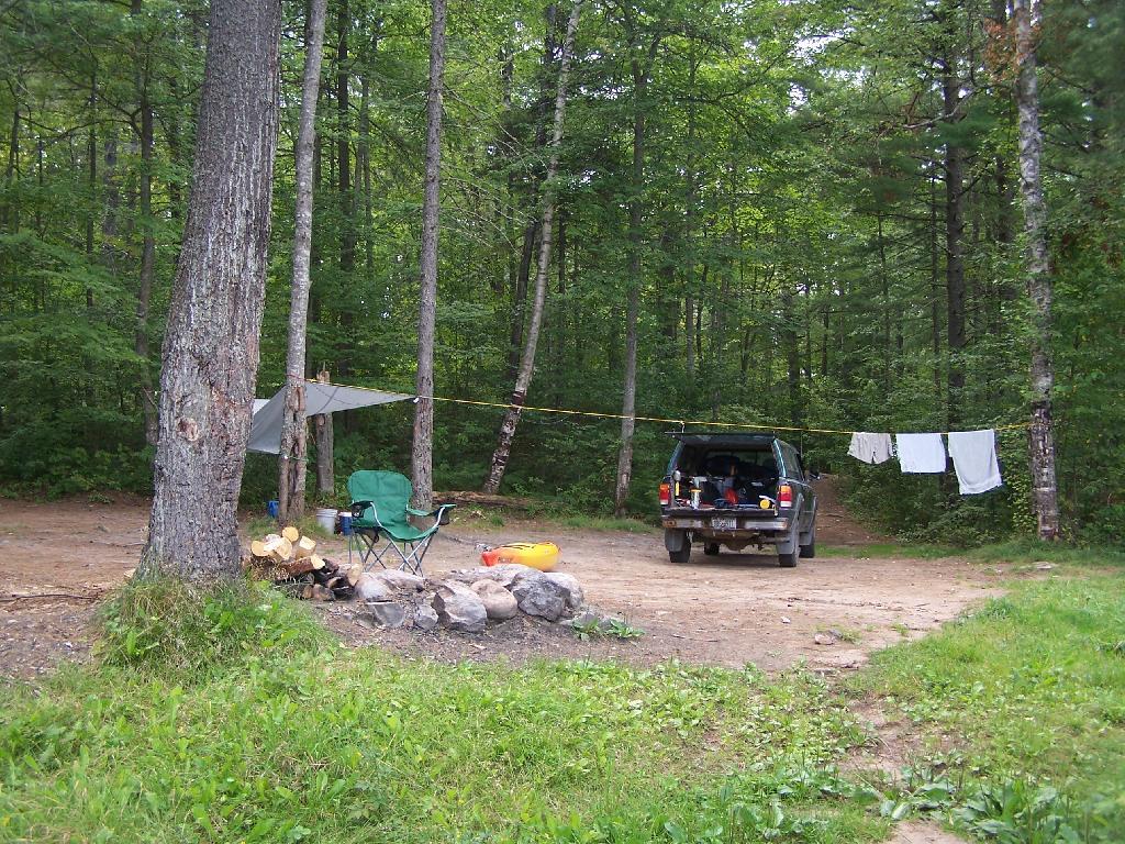
This is campsite No 4 at Mountain Pond. A nice campsite, big, roomy, and private, although the much smaller Campsites 5 is fairly close.
Taken on Saturday August 14, 2010 at Mountain Pond.