North of the Adirondack Park lays a mixture of farm country and sand plains. Some of the land is fertile and used for dairying and other crop growing, but much of it is pretty shallow and easily damaged by the destructive practices of the iron industry, which burned much of the forests at one point for making iron.
Nowadays much of this land is part of State Forest system set into place when Franklin Roosevelt was Governor of New York, Brasher State Forest (St. Lawrence County; lands to the east) and Bombay State Forest (Franklin County; lands to east). Switch to the OpenStreetMap or USGS Topo DRG layers for more information about the forest or browse the blog in category below for more maps.
It is crossed by two major rivers - the Saint Regis River and Deer River. Camping is a popular activity at Walter Pratt Camping Area, a free-campground on Redwater Pond.
http://history.rays-place.com/ny/brasher-ny.htm
I had a North Country colleague from years ago. They said it was pronounced "bra-ah-shere" or something like that. Not brash-er, as I would call it.
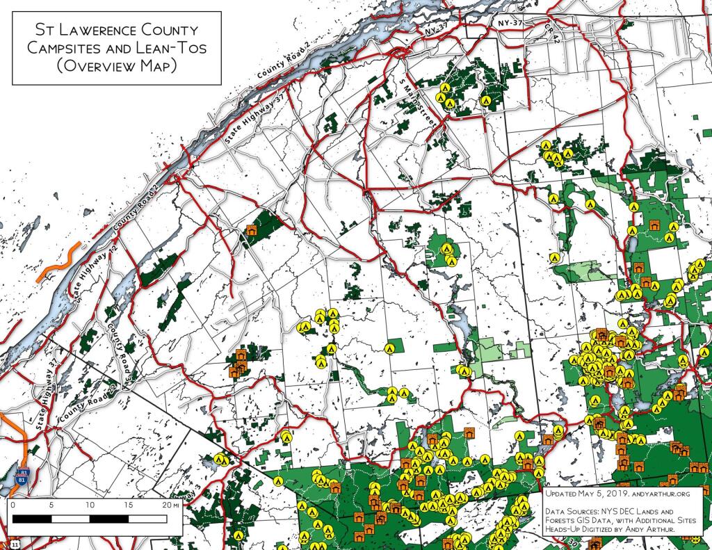
This map shows the locations of campsites on the St. Lawerence Flat Lands and surrounding areas in the north-western Adirondacks. I believe this is a fairly complete map for state land up that way, please see individual state forests for details.
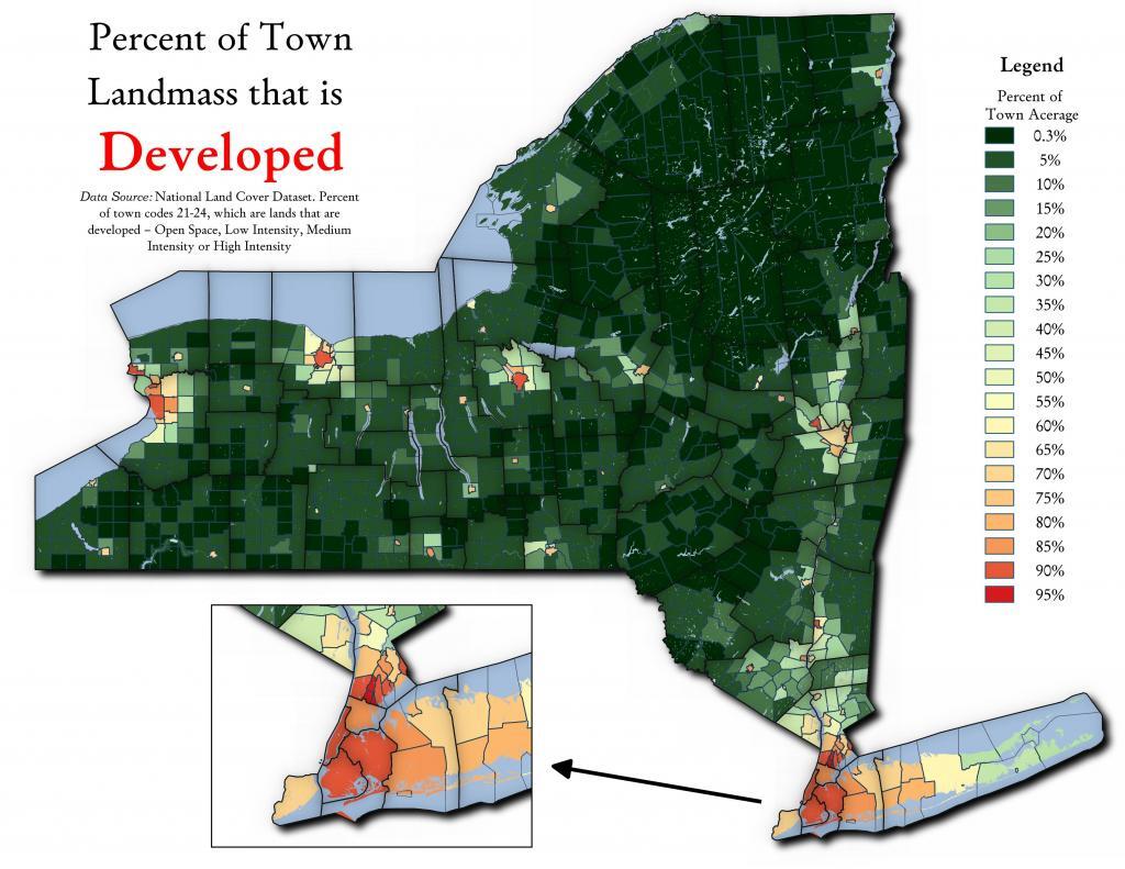
It varies a lot by town, by many of the Upstate towns are largely open space consisting of farms and forests. This analysis using NLCD 2016, includes only landmass and excludes waterways.
A camping permit is required for overnight camping on state forest land. Certain watersheds near exceptional value or high quality waters are posted closed to camping.
For information about campsite availability in Tuscarora State Forest and to request a permit, please contact the district office at 717-536-3191.
https://www.dcnr.pa.gov/StateForests/FindAForest/Tuscarora/Pages/Camping.aspx
Confusion Flats is located in the Independence River Wild Forest and Otter Creek State Forests, and it's a series of sand trails and roads that are popular with horseback riders and off-roaders.
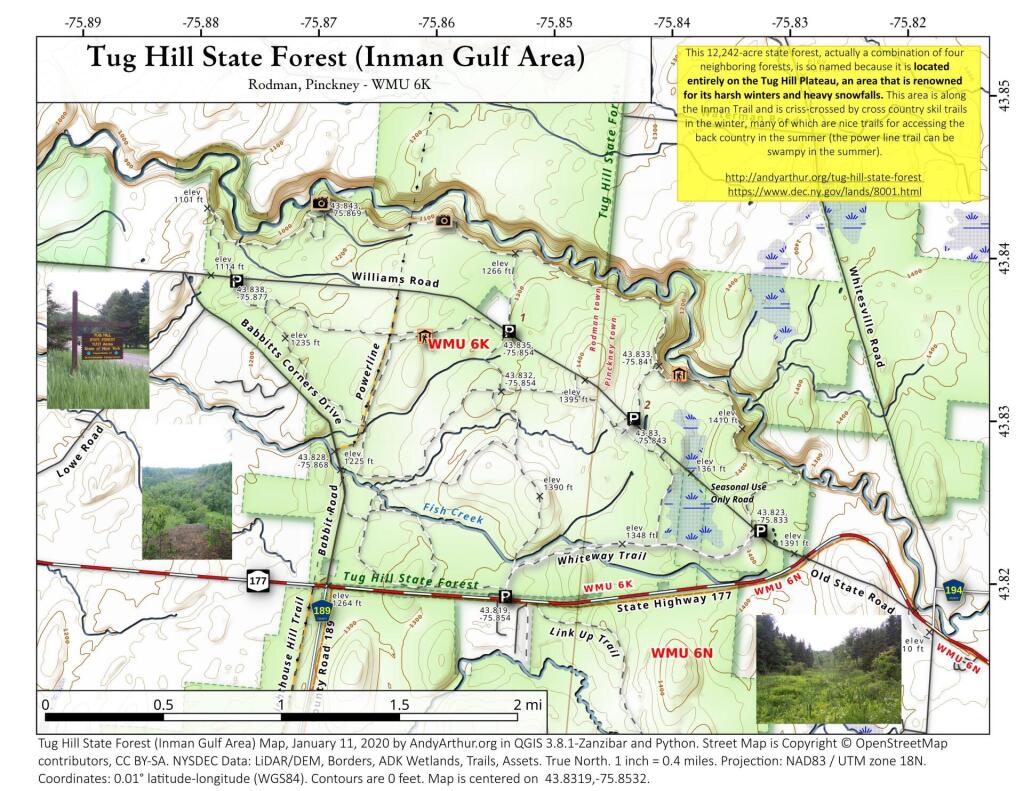
This 12,242-acre state forest, actually a combination of four neighboring forests, is so named because it is located entirely on the Tug Hill Plateau, an area that is renowned for its harsh winters and heavy snowfalls. This area is along the Inman Trail and is criss-crossed by cross country skil trails in the winter, many of which are nice trails for accessing the back country in the summer (the power line trail can be swampy in the summer).
https://andyarthur.org/tug-hill-state-forest
https://www.dec.ny.gov/lands/8001.html
![Red Horse Trail [Expires January 23 2024]](https://andyarthur.org//data/photo_007889_large.jpg)