Red Falls
Hamlet outside of Prattville in the Northern Catskills. As the tax map overlay shows, these lands are city owned.
Hamlet outside of Prattville in the Northern Catskills. As the tax map overlay shows, these lands are city owned.
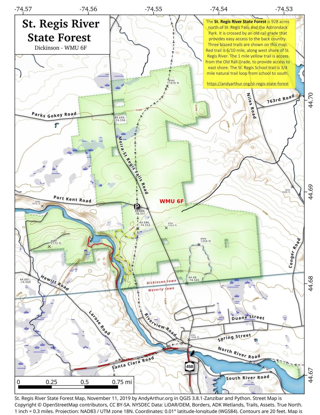
The St. Regis River State Forest is 928 acres north of St. Regis Falls and the Adirondack Park. It is crossed by an old rail grade that provides easy access to the back country. Three blazed trails are shown on this map. Red trail is 6/10 mile, along west shore of St. Regis River. The 1 mile yellow trail is access from the Old Rail Grade, to provide access to east shore. The St. Regis School trail is 3/4 mile natural trail loop from school to south. More details from NYS DEC on St Regis State Forest.
43.33072545558804,-74.6550531605912
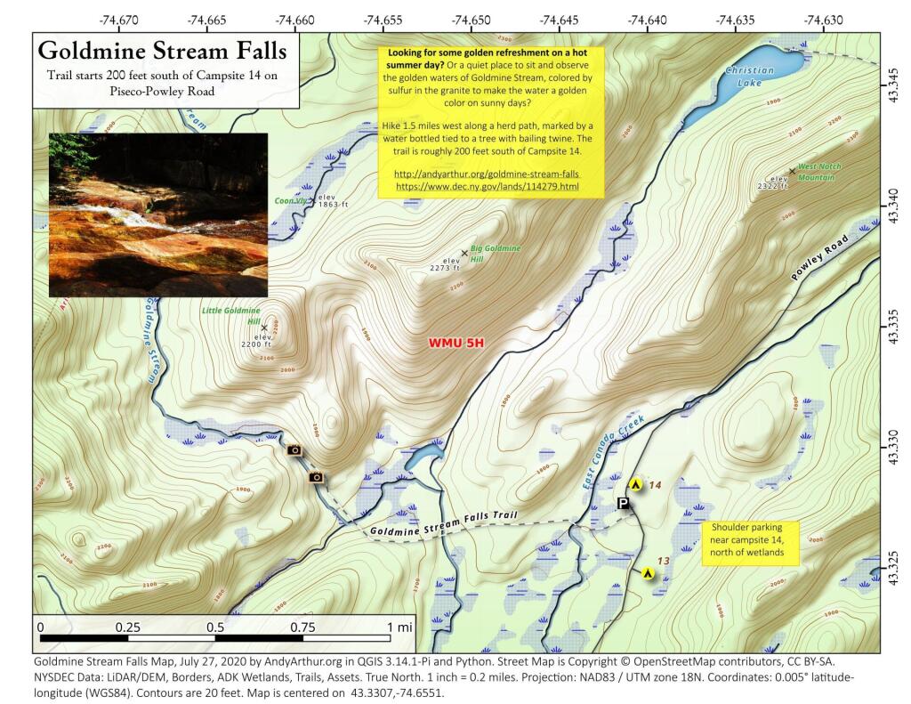
Looking for some golden refreshment on a hot summer day? Or a quiet place to sit and observe the golden waters of Goldmine Stream, colored by sulfur in the granite to make the water a golden color on sunny days?
Hike 1.5 miles west along a herd path, marked by a water bottled tied to a tree with bailing twine. The trail is roughly 200 feet south of Campsite 14.
https://andyarthur.org/goldmine-stream-falls
https://www.dec.ny.gov/lands/114279.html
Old Route 8B is a 1915-era routing of NY 8 and 30 between Wells and Speculator that is now a dead-end after the lower bridge was closed some time ago. It runs between Auger Falls and Speculator, passing closely by Austin Falls. Old Route 8B is most famous for Robert Garrow killing a camper at the Robb Creek Mill and then fleeing up Fly Creek Road. There are several campsites along the road, and Austin Falls is a scenic location where the Sacandaga River runs through a narrow floom. The road, while paved with concrete and letter covered with two layers of asphalt only receives the most minimum of maintenance, and is quite rough and disjointed in locations. Old Route 8A refers to the 1915 routing of NY 8 and 30, which at one time ran closer to Auger Falls and wound into the valley, taking a closer path to the Sacanadaga River.
Through every season, Bellows Falls and Rockingham are beautiful. Visitors can find new favorite restaurants and shops, take advantage of our picturesque views of the Connecticut River and Fall Mountain and enjoy our easy walks through the Village and hiking and biking trails that are being built on our surrounding mountains. History meets the present in our shops in the downtown square, the old mill buildings, the river's beauty and power, and in the Great Falls and the Victorian homes that add charm to our walkable downtown. The first bridge to be built anywhere on the 410-mile long Connecticut River was across the narrow Bellows Falls gorge. Today the downtown district still has some of the look of the 19th century and the feel of the mid 20th. But beneath that look, it is a town that embraces everything new. Arts and culture abound, with a restored Opera House showing first run and classic movies and live entertainment. Nationally known musicians appear regularly in town, and the Vermont Symphony Orchestra performs here several times a year. https://www.vermontvacation.com/explore-vermont/historic-downtowns/bellows-falls
In 1944 there was a proposal to create a Lake Ontario State Parkway. It was to be part of the Seaway Trail project. The parkway was to extend from Charlotte Beach in Rochester, through Monroe, Orleans, and Niagara Counties and end at Niagara Falls. When the Robert Moses State Parkway was proposed, the western terminus was moved north to Fort Niagara.
The construction of the Lake Ontario State Parkway began in the late 1940s, with the first section opening in the early 1950s, linking the Hamlin Beach State Park to NY 261 (Manitou Road). The section through Greece to Charlotte was built in stages during the 1950s and 1960s. The portion between Hamlin Beach state park and Lakeside Beach State Park was planned in the ’60s and finished in 1972. Officially opening February 16, 1973.
There was a US Supreme Court ruling in 1964, that caused Counties to lose their representation in the Assembly. That ruling began to take a toll fairly quickly. With the NYS Legislature putting its focus on the seven counties downstate, the parkway was abandoned, half-finished. Little focus was ever again placed on the Lake Ontario State Parkway, at least not for the next 56 years.
It wasn’t until the Lake Ontario Parkway began to be an eyesore and embarrassment, and even a safety hazard, that the state made any effort to make repairs. The parkway was in such disrepair that drivers had to slow to 35-40 MPH, slower in some places, or risk serious damage to their vehicles. Many users preferred driving on the shoulder rather than over the broken parkway pavement. In 2017, the parkway from Route 19 east to Payne Beach was repaved (approximately 8 miles). In 2018, seven miles from Route 19 to Route 237 were repaved, but the shoulders in this stretch narrowed from 12 to 8 feet.
As of today, about 12 miles of the western end of the parkway is in poor condition. The only consideration actually keeping that stretch open is that it is treated as a sessonal highway and is viewed as a historical landmark. With serious deterioration, lack of state funding, failure to complete the parkway to Fort Niagara, and no plans on the books, the Lake Ontario Parkway has become a highway to nowhere.
Source: https://www.glogowskiforassembly.com/a-road-to-no-where/
15 years ago, I drove the Lake Ontario State Parkway. It was in bad shape back then, but was an extremely pleasant drive for the rural country with almost no traffic on it if you didn't mind the repeated bumps of the 50 year old, rarely repaired pavement.
At one point, US 4 in Vermont was proposed to be an expressway across the state. Nowadays it dead ends at US 7 South of Rutland, across from what I'd now the Diamond Run Maul. This would have become part of the Modified Central Route of the proposed Interstate 92.
"MODIFIED" CENTRAL ROUTE: 281.6 miles from the area of Glens Falls, New York to Portland, Maine. This corridor would have required 97.1 miles of new construction and 70.2 miles of upgrading existing facilities (a 1968-1971 Interstate-quality upgrade of US 4 near Rutland, Vermont is included in this figure). Approximately 114.2 miles would have utilized already existing Interstate highways (I-89 in Vermont and New Hampshire, and I-393 in New Hampshire). The route, which was estimated to cost $346 million by the time it was completed in 1979, would have gone through Rutland and White River Junction, Vermont; Lebanon and Concord, New Hampshire; and Sanford and Portland, Maine. (An extension of the central route east to Calais, Maine was not considered for this study.)