July 29, 2016 midnight update

Good morning, early on my half birthday! Cloudy and 67 degrees in the Allegheny National Forest as we head into the midnight hour of Friday. Calm wind. The dew point is 64 degrees. Pretty muggy. We had some showers but now they’ve stopped. The radar showed a severe thunderstorm, but it passed to the north of where I am. 

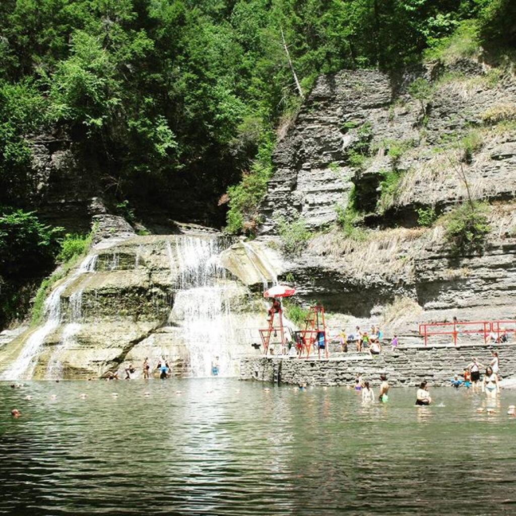
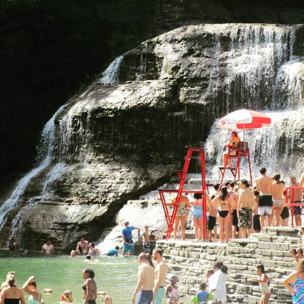
Today I went for a swim for a few hours at Watkins Glen then got a massive black raspberry twist cone at the Glen Dairy Bar. Drove to the Allegheny National Forest, after exploring campsites along FR 137 up by the Willow Run ATV Trail, decided on camping on Forest Road 259, at a favorite campsite from years past. This is more convenient for tomorrow when I drive out to Erie. Assuming we have good weather, I want to watch the sunset from Rim Rock. I’m leaving my campsite up tomorrow, secured by security cables so if I get back after dark, I just have to unlock and uncover things and light the lantern and plug the lights into the truck.  I also set up my tent again for storing paper products, charcoal, dirty clothes, etc. Keeps them dry and out of the way. I also  set up a tarp so I can duck under it if we get showers. 

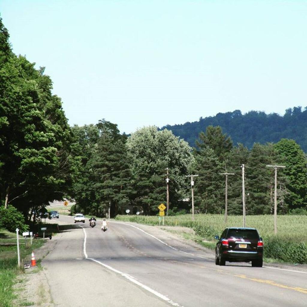
There was a major detour on US 6 between Port Allegany to Smethport, and I ended up taking a road through Bradford, Penna. It turned out to be a hell of a longer trip, and wasn’t too scenic to boot. That said, I enjoy exploring new roads. 

Tonight for rest of the night, we will have a chance of showers and thunderstorms. Cloudy, with a low of 62 degrees at 6am. Typical for tonight. Light north wind. Chance of precipitation is 50%. New rainfall amounts of less than a tenth of an inch, except higher amounts possible in thunderstorms. Maximum dew point of 65 at 10pm. The record low of 47 occurred back in 1987. Waning Crescent Moon tonight with 30% illuminated. The moon will rise around 2:09 am. The New Moon Moon is on Tuesday with mostly clear skies expected. The Full β€œStrugeon” Moon is in 3 weeks.

Tomorrow in the northern Allegheny National Forest, we will have a slight chance of showers before 11am, then a chance of showers and thunderstorms after 2pm. Mostly cloudy, with a high of 78 degrees at 2pm. Three degrees below normal. Fewer clouds as you head west, like with me going to Presque Isle State Park in Erie, Penna. North wind 3 to 7 mph. Chance of precipitation is 40%. New rainfall amounts of less than a tenth of an inch, except higher amounts possible in thunderstorms. Maximum dew point of 62 at 6am. The record high of 97 was set in 1894. The sun will rise at 6:06 am with the first light at 5:34 am, which is 59 seconds later then yesterday.

Tomorrow I plan to go to Presque Isle State Park and go swimming in Lake Erie. The weather looks decent there tomorrow. It’s a nice drive and those big sandy beaches are fun. Might be some good waves with the changing weather. For Saturday we will see. I could pack up, go to Allegany State Park and go swimming in Quaker Lake then camp somewhere on the way home. Or if it looks like they have better weather in the Finger Lakes, I could head back there and hit up Watkins Glen pool one last time and overnight in that National Forest. Or remain at this campsite and try the beach on the Allegheny Reservoir. We will see. 

0.1 inch of rain expected between Thursday 10pm and Friday 7pm. 0.2 inch of rain expected between Saturday 8am and Sunday 7pm. Within the next four days, a total of 0.3 inches of rain is expected.

Looking ahead, State Fair Opens is in 4 weeks, First Day of Sunset Before 7 PM in Albany is in 3 weeks, First Day of Autumn is in 8 weeks, Last Recorded Day Above in 90 in Albany is in 10 weeks, First Day with Average High Below 60 is in 12 weeks and Thanksgiving is in 17 weeks.

Friday Night. Chance of T-storms then Chance of Showers and 58 degrees, 61 max dew point, 6:08 sunrise.
Saturday. Chance of T-storms and 76 degrees, 61 max dew point, 8:34 sunset.
Saturday Night. Chance of T-storms and 59 degrees, 61 max dew point, 6:09 sunrise.
Sunday. Chance of T-storms and 76 degrees, 63 max dew point, 8:33 sunset.
Sunday Night. Chance of T-storms and 58 degrees, 61 max dew point, 6:10 sunrise.
Monday. Mostly Sunny and 79 degrees, 62 max dew point, 8:32 sunset.
Monday Night. Mostly Clear and 58 degrees, 61 max dew point, 6:11 sunrise.
Tuesday. Sunny and 81 degrees, 60 max dew point, 8:31 sunset.
Tuesday Night. Mostly Clear and 61 degrees, 60 max dew point, 6:12 sunrise.
Wednesday. Mostly Sunny and 83 degrees, 64 max dew point, 8:29 sunset.

NY 13

Taken on Thursday July 28, 2016 at Naples.

July 28, 2016 Morning

Good morning! Happy Thursday. Partly sunny and 80 degrees in Watkins Glen. Calm wind. The dew point is 63 degrees. 

All packed up and back at the Watkins Glen pool for a quick swim before I head west to the Allegheny National Forest. Going to also visit the Glen Dairy Bar and get their Black Raspberry Soft Ice Cream before I leave town. Their brownie sundae was amazing with half of it being large chunks of homemade brownies. 

Tomorrow going swimming at the beautiful Quaker Lake at Allegany State Park then maybe Presque Isle on Saturday. I like the Finger Lakes but I’m ready for a change after six days. Change is a good thing. 

Today will have a chance of showers, mainly after 3pm. Partly sunny, with a high of 87 degrees at 1pm. Five degrees above normal. Calm wind. Chance of precipitation is 30%. New precipitation amounts of less than a tenth of an inch possible. Maximum dew point of 63 at 11am. The record high of 99 was set in 1929. The sun will set at 8:30 pm with dusk around 9:02 pm, which is 1 minutes and 4 seconds earlier than yesterday. Today will have 14 hours and 33 minutes of daylight, a decrease of 2 minutes and 4 seconds over yesterday.

Tonight will have a chance of showers and thunderstorms. Cloudy, with a low of 65 degrees at 4am. Three degrees above normal. North wind around 5 mph becoming calm in the evening. Chance of precipitation is 50%. New rainfall amounts of less than a tenth of an inch, except higher amounts possible in thunderstorms. Maximum dew point of 66 at 8pm. The record low of 47 occurred back in 1987.

0.2 inch of rain expected between Thursday 2pm and Friday 7pm. 0.5 inch of rain expected between Saturday 8pm and Monday 7am. Within the next four days, a total of 0.8 inches of rain is expected.We have some muggy weather coming up. Thursday 8pm – Thursday 11pm. Maximum temperature will be 79 degrees, a heat index reaching 79, and a maximum dew point of 66. Friday 5am – Friday 1pm. Maximum temperature will be 80 degrees, a heat index reaching 82, and a maximum dew point of 66. Thursday 7am – Thursday 9am. Maximum temperature will be 73 degrees and a maximum dew point of 65.

There are 4 weeks until State Fair Opens when the sun will be setting at 7:51 pm with dusk at 8:20 pm. The average high temperature is 79 degrees, with a record high of 99 in 1947.

July 27, 2016 10 PM Update

Gond evening! Mostly clear and 72 degrees in Burdett. Calm wind. The dew point is 60 degrees. Back at Foster Pond looking at the stars on my final night at the Finger Lakes National Forest. I was going to do some fishing but it got late, and decided to just sit down by the lake on my back. Even at ten pm, it’s really not that dark in the west for looking at the stars. In a little bit, I’ll wander back to camp and start a small fire and stay up for a while before retiring for the night. 

Tonight will be mostly clear, with a low of 67 degrees at 5am. Three degrees above normal. Light and variable wind becoming northwest around 5 mph after midnight. Maximum dew point of 60 at 10pm. The record low of 44 occurred back in 1971. Waning Crescent Moon tonight with 40% illuminated. The moon will rise around 1:20 am. The New Moon Moon is on Tuesday with partly cloudy skies expected. The Full β€œStrugeon” Moon is on Thursday, August 18th.

It was a fun day, swimming at Robert H Treman State Park then going to Watkins Glen for ice cream and swimming in the Watkins Glen pool. I stopped at the Watkins Glen library and checked my email and did some work on my laptop. Cooked some bratwurst for dinner. 

Tomorrow will have a chance of showers and thunderstorms, mainly after 3pm. Partly sunny, with a high of 83 degrees at 2pm. One degrees above normal. West wind 3 to 5 mph. Chance of precipitation is 30%. New rainfall amounts of less than a tenth of an inch, except higher amounts possible in thunderstorms. Maximum dew point of 61 at 7am. The record high of 99 was set in 1929. The sun will rise at 5:55 am with the first light at 5:23 am, which is 1 minutes and 0 seconds later then yesterday.
0.2 inch of rain expected between Thursday 2pm and Friday 7pm. 0.1 inch of rain expected between Saturday 8pm and Sunday 7am. Within the next four days, a total of 0.3 inches of rain is expected.

Tomorrow I’m taking down camp, will hit the Watkins Glen State Park Pool briefly before heading down to Pennsylvania. Going to camp the next three nights in the Allegheny National Forest. I will miss the Finger Lakes but it’s time to move on. Plan to visit Allegany State Park and Quaker Lake for some swimming and possibly Erie PA and Presque Isle State Park on Saturday. We’ll see. 

Looking ahead, National Smores Day is in 2 weeks, Thrift Shop Day is in 3 weeks, Day When It Got Below Freezing in Albany is in 7 weeks, Yom Kippur is in 11 weeks and First Day with Temperatures Recorded Below Zero is in 18 weeks.
Thursday Night. Chance of T-storms and 65 degrees, 62 max dew point, 5:57 sunrise.
Friday. Chance of T-storms and 78 degrees, 63 max dew point, 8:29 sunset.
Friday Night. Partly Cloudy and 61 degrees, 60 max dew point, 5:58 sunrise.
Saturday. Mostly Sunny and 78 degrees, 58 max dew point, 8:28 sunset.
Saturday Night. Chance of Showers and 61 degrees, 57 max dew point, 5:59 sunrise.
Sunday. Chance of T-storms and 77 degrees, 62 max dew point, 8:27 sunset.
Sunday Night. Chance of T-storms and 61 degrees, 62 max dew point, 6:00 sunrise.
Monday. Mostly Sunny and 80 degrees, 61 max dew point, 8:26 sunset.
Monday Night. Partly Cloudy and 62 degrees, 61 max dew point, 6:01 sunrise.
Tuesday. Mostly Sunny and 84 degrees, 61 max dew point, 8:24 sunset.