Map: Tioughnioga WMA
Download a High Resolution JPEG Image of the Tioughnioga WMA or an Adobe Acrobat Printable PDF of the Tioughnioga WMA.

Bookmark my free Interactive GPS Map for your phone:
https://andyarthur.org/ny
... shows your location as a blue dot in relationship to campsites, trails, state land. This online map requires cell service, won't work in remote country, so also bring a paper map.
Free Download of New & Historical USGS 1:24k Topograpic Maps
Interactive maps with backcountry and roadside camping: New York, Pennsylvania, West Virginia & Vermont. List of NYS DEC Lean-Tos and Firetowers.
Google Spreadsheet with Roadside, Primitive and Pay Campsites
More about Tioughnioga Wildlife Management Area...
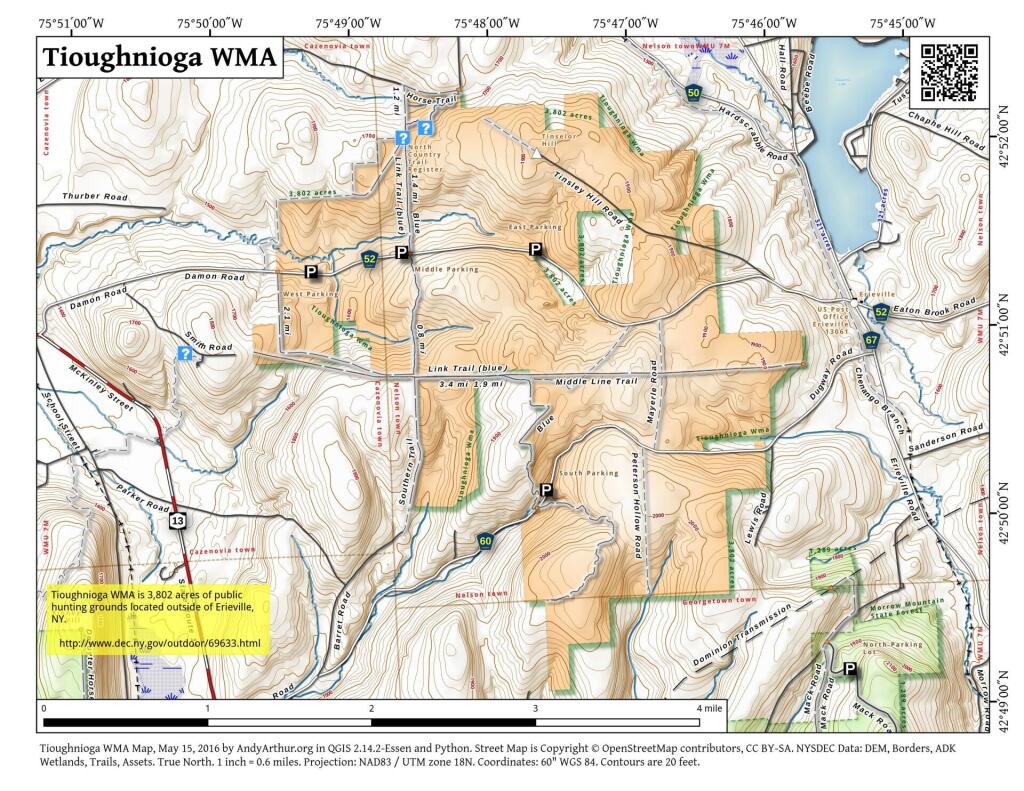
Tioughnioga Wildlife Management Area, totaling some 3737 acres, is located in southwestern Madison County between the villages of New Woodstock and Erieville about six miles southeast of Cazenovia. Easy access is provided from NY Route 13 via Damon Road or Dugway Road. The 7 ½ minute topographic map covering the area is Erieville.
Topography and Wildlife
Tioughnioga lies in the physiographic region of New York known as the Appalachian Highlands with the many hills and valleys of the region forming a rolling topography. The area is on a divide that separates the St. Lawrence River drainage from the Susquehanna River drainage and has an altitude ranging from 1500 to 2100 feet above sea level. Current objectives for the area are to provide habitat for a variety of wildlife species and to permit wildlife related recreation. Management techniques to provide the food, cover and shelter requirements for various wildlife species are carried out with monies derived mainly from hunting license fees and federal taxes on sporting arms and ammunition. On Tioughnioga, the management efforts are directed towards maintaining the diversity of cover that has been established from past management, primarily through mowing and the sale of wood products. The sale of wood products also provides for improvement of the forestry resource.
The vegetation of this upland area is characterized as northern hardwoods, dominated by beech, yellow birch, sugar maple and hemlock. Wildlife species, such as turkey, white-tailed deer, beaver, ruffed grouse and upland song birds may be observed. Of special interest is a green heron rookery.
History
Prior to 1935, the area was used for dairy farming. However poor soils, harsh climate and difficult economic conditions resulted in much of the area being purchased by the US Department of Agriculture as part of a resettlement program. The land was later transferred to New York State. Early development work, utilizing WPA (Work Project Act) and CCC (Civilian Conservation Corps) labor consisted of planting open fields to a mixture of trees and shrubs. Over 1,000000 conifers, hardwoods and food-bearing shrubs were planted. Woodland cutting was carried out, and a number of shallow water impoundments were constructed to provide habitat for waterfowl and other species of water birds.
A good system of town, county and state roads provides access for a variety of activities. The area is heavily used for big and small game hunting and is controlled by statewide regulations. Hiking, birding and cross country skiing are other popular activities.
Since Tioughnioga is a wildlife management area, activities not compatible with wildlife objectives are prohibited. A few of the prohibited activities include off road vehicular travel (i.e. cars, snowmobiles, motorcycles, all terrain vehicles) swimming and boating with motors.
... photos, maps and other content from from Tioughnioga Wildlife Management Area.