Search Results for: map moose plains big t 2

USGS Topographic Maps – Dutchess to Livingston Counties

Counties: Albany to Delaware / Dutchess to Livingston / Madison to Otsego / Putnam to Suffolk / Sullivan to Yates

Browse Topographic Maps: Full State / Historical USGS Topographic Maps

Dutchess County

PDF (50-60 MB Download) Historical USGS Topo Maps State Lands (Links to DEC Website) Towns (Percent of Town’s Area)
Current Amenia GeoPDF Map
1958 Map No. 136605, 1958 Map No. 136606, 1958 Map No. 136607, 1958 Map No. 136608, 1958 Map No. 137065 Wassaic Multiple Use Area, Wassaic Creek Fishing Access Amenia (91%), Dover (2%), Stanford (3%), Washington (18%)
Current Ancram GeoPDF Map
1948 Map No. 136625, 1948 Map No. 710141, 1960 Map No. 136626, 1960 Map No. 136627, 1960 Map No. 137076, 1960 Map No. 710139 Roeliff Jansenkill Multiple Use Area, New Forge State Forest, Doodletown Wildlife Management Area Ancram (16%), Gallatin (80%), Milan (3%), Pine Plains (3%), Taghkanic (36%)
Current Clermont GeoPDF Map
1963 Map No. 137177, 1963 Map No. 137654, 1963 Map No. 137655, 1963 Map No. 137656 NA Clermont (63%), Gallatin (19%), Germantown (21%), Livingston (31%), Milan (21%), Red Hook (30%), Taghkanic (2%)
Current Copake GeoPDF Map
1953 Map No. 137709, 1953 Map No. 137710, 1953 Map No. 137711, 1953 Map No. 137712 Doodletown Wildlife Management Area Ancram (71%), Copake (46%), North East (14%), Taghkanic (3%)
Current Dover Plains GeoPDF Map
1944 Map No. 137886, 1958 Map No. 137890, 1958 Map No. 137891, 1958 Map No. 137892, 1958 Map No. 137893, 1998 Map No. 137336 Swamp River Fishing Access, Swamp River Waterway Access, West Mountain State Forest Amenia (0%), Dover (85%), Washington (1%)
Current Hopewell Junction GeoPDF Map
1957 Map No. 129768, 1957 Map No. 129769, 1957 Map No. 129770, 1981 Map No. 129767 NA Beekman (1%), East Fishkill (74%), Fishkill (14%), Kent (2%), Wappinger (27%)
Current Hyde Park GeoPDF Map
1963 Map No. 130048, 1963 Map No. 130049, 1980 Map No. 130050, 1980 Map No. 130051 Black Creek Waterway Access, Chodikee Lake Wetlands, Crum Elbow Creek Waterway Access, Black Creek State Forest, Crum Elbow Creek Fishing Access Clinton (2%), Esopus (44%), Hyde Park (79%), Lloyd (14%), Rhinebeck (0%)
Current Kingston East GeoPDF Map
1963 Map No. 130035, 1963 Map No. 130036, 1963 Map No. 130037, 1963 Map No. 137296, 1963 Map No. 137298 NA Clinton (0%), Esopus (16%), Hyde Park (1%), Kingston city (52%), Red Hook (15%), Rhinebeck (71%), Ulster (35%)
Current Millbrook GeoPDF Map
1947 Map No. 130580, 1960 Map No. 130583, 1960 Map No. 130584, 1960 Map No. 137450, 1960 Map No. 137451 Wappinger Creek Fishing Access Pleasant Valley (0%), Stanford (28%), Washington (70%)
Current Millerton GeoPDF Map
1955 Map No. 130590, 1955 Map No. 130591, 1955 Map No. 137452, 1955 Map No. 137453 NA Amenia (9%), Ancram (12%), North East (86%), Pine Plains (31%), Stanford (3%)
Current Pawling GeoPDF Map
1945 Map No. 135979, 1958 Map No. 135980, 1958 Map No. 135981, 1958 Map No. 135982, 1958 Map No. 136773, 1998 Map No. 136774 West Mountain State Forest, Great Swamp WMA, Cranberry Mountain WMA Dover (7%), Patterson (26%), Pawling (70%)
Current Pine Plains GeoPDF Map
1948 Map No. 129004, 1960 Map No. 129005, 1960 Map No. 129006, 1960 Map No. 136805, 1960 Map No. 136806 Shekomeko Creek Parking Fishing Access, Lafayetteville Multiple Use Area, Stissing Mountain Multiple Use Area Ancram (1%), Gallatin (1%), Milan (20%), North East (0%), Pine Plains (66%), Stanford (54%)
Current Pleasant Valley GeoPDF Map
1957 Map No. 129049, 1957 Map No. 129050, 1957 Map No. 129051 Taconic Hereford Multiple Use Area Beekman (2%), East Fishkill (1%), Hyde Park (3%), LaGrange (94%), Pleasant Valley (26%), Poughkeepsie (13%), Wappinger (11%)
Current Poughkeepsie GeoPDF Map
1957 Map No. 129158, 1957 Map No. 129159, 1957 Map No. 136830, 1995 Map No. 136831 NA Hyde Park (8%), LaGrange (0%), Lloyd (43%), Marlborough (39%), Poughkeepsie city (100%), Poughkeepsie (70%), Wappinger (2%)
Current Poughquag GeoPDF Map
1948 Map No. 129160, 1948 Map No. 129161, 1960 Map No. 129162, 1960 Map No. 129163, 1960 Map No. 129164, 1960 Map No. 136833 White Pond Multiple Use Area, Depot Hill Multiple Use Area, West Mountain State Forest, Big Buck Mountain Multiple Use Area, Sylvan Lake Waterway Access Beekman (72%), Dover (0%), East Fishkill (24%), Kent (10%), Patterson (5%), Pawling (30%)
Current Rock City GeoPDF Map
1963 Map No. 136098, 1963 Map No. 136099, 1963 Map No. 136866 NA Clinton (35%), Hyde Park (0%), Milan (55%), Red Hook (15%), Rhinebeck (29%), Stanford (8%)
Current Salt Point GeoPDF Map
1963 Map No. 129336, 1963 Map No. 129337, 1963 Map No. 136881 Taconic Hereford Multiple Use Area Clinton (63%), Hyde Park (10%), Pleasant Valley (73%), Stanford (4%), Washington (2%)
Current Saugerties GeoPDF Map
1963 Map No. 129404, 1963 Map No. 136889, 1963 Map No. 136890, 1963 Map No. 136891, 1963 Map No. 136892, 1997 Map No. 136893 Turkey Point State Forest, Tivoli Bays WMA Clermont (33%), Germantown (15%), Red Hook (39%), Saugerties (41%), Ulster (12%)
Current Verbank GeoPDF Map
1946 Map No. 139478, 1960 Map No. 136984, 1960 Map No. 139482, 1960 Map No. 139483 West Mountain State Forest, Taconic Hereford Multiple Use Area Beekman (25%), Dover (5%), LaGrange (6%), Pleasant Valley (1%), Union Vale (100%), Washington (9%)
Current Wappingers Falls GeoPDF Map
1956 Map No. 140039, 1956 Map No. 140040, 1956 Map No. 140041 Stonykill Environmental Education Center, Baxtertown Woods WMA Beacon city (64%), Fishkill (56%), Marlborough (24%), Newburgh city (3%), Newburgh (12%), Poughkeepsie (17%), Wappinger (60%)
Current West Point GeoPDF Map
1941 Map No. 140199, 1947 Map No. 140198, 1957 Map No. 137014, 1957 Map No. 140200, 1957 Map No. 140201, 1957 Map No. 140202 NA Beacon city (36%), Cornwall (8%), Fishkill (29%), Highlands (21%), New Windsor (0%), Newburgh city (4%), Philipstown (63%), Putnam Valley (7%)

Erie County

PDF (50-60 MB Download) Historical USGS Topo Maps State Lands (Links to DEC Website) Towns (Percent of Town’s Area)
Current Akron GeoPDF Map
1949 Map No. 136539, 1951 Map No. 136540, 1951 Map No. 710097 Onondaga Escarpment Unique Area, John White WMA, Tonawanda WMA Alabama (46%), Newstead (17%), Pembroke (24%), Royalton (6%), Tonawanda Reservation (100%), Tonawanda Reservation (100%), Tonawanda Reservation (100%)
Current Angola GeoPDF Map
1960 Map No. 136649, 1960 Map No. 136650 NA Evans (39%)
Current Arcade GeoPDF Map
1966 Map No. 136682, 1966 Map No. 136683 NA Arcade (57%), Freedom (12%), Holland (7%), Java (12%), Sardinia (19%), Yorkshire (14%)
Current Ashford Hollow GeoPDF Map
1964 Map No. 136700, 1964 Map No. 136701, 1964 Map No. 136702, 1964 Map No. 710169 NA Ashford (64%), Concord (9%), East Otto (36%), Ellicottville (2%)
Current Buffalo NE GeoPDF Map
1948 Map No. 123033, 1950 Map No. 123034, 1965 Map No. 123035 NA Amherst (23%), Buffalo city (52%), Cheektowaga (43%), Tonawanda (37%)
Current Buffalo NW GeoPDF Map
1950 Map No. 123036, 1950 Map No. 123038, 1965 Map No. 123039, 1965 Map No. 123040 Motor Island WMA Buffalo city (22%), Grand Island (25%), Tonawanda city (3%), Tonawanda (47%)
Current Buffalo SE GeoPDF Map
1948 Map No. 123041, 1950 Map No. 123042, 1965 Map No. 123043 NA Buffalo city (26%), Cheektowaga (2%), Hamburg (34%), Lackawanna city (100%), Orchard Park (22%), West Seneca (53%)
Current Clarence GeoPDF Map
1950 Map No. 137629, 1965 Map No. 137630 Tillman Road WMA Alden (63%), Clarence (14%), Lancaster (35%), Newstead (24%)
Current Clarence Center GeoPDF Map
1950 Map No. 137625, 1950 Map No. 137626, 1965 Map No. 137627 Great Baehre Swamp WMA Amherst (28%), Clarence (41%), Lockport (21%), Pendleton (29%)
Current Colden GeoPDF Map
1955 Map No. 137679, 1955 Map No. 137680, 1955 Map No. 137681, 1955 Map No. 137806 NA Aurora (38%), Boston (37%), Colden (49%), Orchard Park (26%)
Current Collins Center GeoPDF Map
1963 Map No. 137682, 1963 Map No. 137683, 1963 Map No. 137684 Cattaraugus Creek Waterway Access, Zoar Valley Multiple Use Area, Zoar Valley Unique Area, East Otto State Forest Collins (35%), Concord (5%), East Otto (37%), Otto (61%)
Current Corfu GeoPDF Map
1950 Map No. 137814, 1950 Map No. 137815 NA Alden (29%), Darien (53%), Newstead (11%), Pembroke (33%)
Current Cowlesville GeoPDF Map
1949 Map No. 137726, 1951 Map No. 137727 NA Alden (3%), Bennington (62%), Darien (5%), Marilla (14%), Sheldon (20%), Wales (11%)
Current East Aurora GeoPDF Map
1950 Map No. 137994, 1965 Map No. 137996, 1965 Map No. 137997 NA Alden (5%), Aurora (15%), Elma (40%), Lancaster (5%), Marilla (86%), Wales (24%)
Current Eden GeoPDF Map
1949 Map No. 138035, 1965 Map No. 138036 Eighteen Mile Creek Access Eden (43%), Evans (40%), Hamburg (31%)
Current Farnham GeoPDF Map
1960 Map No. 138142, 1960 Map No. 138143 NA Brant (61%), Cattaraugus Reservation (54%), Cattaraugus Reservation (49%), Cattaraugus Reservation (100%), Evans (13%), Hanover (20%), Perrysburg (17%)
Current Gowanda GeoPDF Map
1963 Map No. 129589, 1963 Map No. 129590 Zoar Valley Multiple Use Area, Zoar Valley Unique Area Cattaraugus Reservation (39%), Cattaraugus Reservation (8%), Collins (25%), Dayton (33%), Otto (11%), Perrysburg (30%), Persia (69%)
Current Hamburg GeoPDF Map
1948 Map No. 129666, 1965 Map No. 129667, 1965 Map No. 129668, 1965 Map No. 129669 Hampton Brook Woods WMA Boston (45%), Eden (38%), Hamburg (36%), Orchard Park (23%)
Current Holland GeoPDF Map
1955 Map No. 129880, 1955 Map No. 129881, 1979 Map No. 129879 NA Aurora (25%), Colden (30%), Holland (53%), Wales (44%)
Current Lancaster GeoPDF Map
1950 Map No. 130212, 1965 Map No. 130213 Reinstein Woods Nature Preserve And Environmental Education Center Amherst (17%), Cheektowaga (47%), Clarence (21%), Lancaster (54%)
Current Langford GeoPDF Map
1960 Map No. 130218, 1960 Map No. 130219 Clear Lake WMA Boston (10%), Collins (23%), Concord (18%), Eden (9%), North Collins (57%)
Current Niagara Falls GeoPDF Map
1949 Map No. 128711, 1965 Map No. 128712 NA Grand Island (9%), Niagara Falls city (67%), Niagara (10%)
Current North Collins GeoPDF Map
1960 Map No. 128742, 1960 Map No. 128743 NA Brant (39%), Cattaraugus Reservation (7%), Cattaraugus Reservation (41%), Collins (17%), Eden (10%), Evans (8%), North Collins (43%), Perrysburg (4%)
Current Orchard Park GeoPDF Map
1950 Map No. 128935, 1965 Map No. 128936, 1965 Map No. 128937, 1965 Map No. 137486, 1965 Map No. 137487 Cazenovia Creek Fwma Aurora (22%), Cheektowaga (7%), Elma (60%), Lancaster (7%), Orchard Park (29%), West Seneca (47%)
Current Sardinia GeoPDF Map
1957 Map No. 129402, 1957 Map No. 129403, 1957 Map No. 136888 Cattaraugus Creek Fishing Access Parking Ashford (2%), Colden (8%), Holland (15%), Sardinia (80%), Yorkshire (14%)
Current Silver Creek GeoPDF Map
1943 Map No. 136171, 1960 Map No. 136168, 1960 Map No. 136172 NA Brant (0%), Cattaraugus Reservation (3%), Hanover (22%), Sheridan (27%)
Current Springville GeoPDF Map
1954 Map No. 139842, 1954 Map No. 139843 NA Ashford (0%), Boston (8%), Colden (12%), Concord (68%), Sardinia (1%)
Current Strykersville GeoPDF Map
1957 Map No. 139925, 1957 Map No. 139926 NA Holland (25%), Java (45%), Sheldon (37%), Wales (20%)
Current Tonawanda East GeoPDF Map
1950 Map No. 139339, 1950 Map No. 139340, 1965 Map No. 139341, 1980 Map No. 139342 NA Amherst (31%), North Tonawanda city (64%), Pendleton (57%), Tonawanda city (41%), Tonawanda (13%), Wheatfield (39%)
Current Tonawanda West GeoPDF Map
1948 Map No. 139343, 1948 Map No. 139344, 1950 Map No. 139345, 1965 Map No. 139347 Spicer Creek WMA Grand Island (66%), Niagara Falls city (30%), Niagara (65%), North Tonawanda city (36%), Tonawanda city (57%), Tonawanda (3%), Wheatfield (51%)
Current Wolcottsville GeoPDF Map
1950 Map No. 140363, 1965 Map No. 140364 Tonawanda WMA, Tonawanda Creek Fishing Access Clarence (25%), Lockport (2%), Newstead (47%), Royalton (23%)

Essex County

PDF (50-60 MB Download) Historical USGS Topo Maps State Lands (Links to DEC Website) Towns (Percent of Town’s Area)
Current Ampersand Lake GeoPDF Map
NA Saranac Lakes Wild Forest, High Peaks Wilderness Harrietstown (24%), Newcomb (1%)
Current Au Sable Forks GeoPDF Map
NA Taylor Pond Wild Forest, Wilmington Wild Forest Au Sable (2%), Black Brook (17%), Chesterfield (1%), Jay (43%), Wilmington (0%)
Current Bad Luck Mountain GeoPDF Map
NA Unclassified, Hudson Gorge Wilderness, Blue Mountain Wild Forest, Jessup River Wild Forest, Vanderwhacker Mountain Wild Forest, Siamese Ponds Wilderness, Essex Chain Lakes Primitive Area, Pine Lake Primitive Area Indian Lake (12%), Minerva (10%), Newcomb (3%)
Current Bloomingdale GeoPDF Map
NA Mckenzie Mountain Wilderness, Taylor Pond Wild Forest, Debar Mountain Wild Forest, Saranac Lakes Wild Forest, Buck Pond Campground Franklin (21%), St. Armand (30%)
Current Blue Ridge GeoPDF Map
NA Hammond Pond Wild Forest, Vanderwhacker Mountain Wild Forest, Hoffman Notch Primitive Area, Hoffman Notch Wilderness, High Peaks Wilderness North Hudson (19%), Schroon (13%)
Current Charlotte GeoPDF Map
NA Split Rock Wild Forest Essex (35%), Westport (1%), Willsboro (11%)
Current Cheney Pond GeoPDF Map
NA Vanderwhacker Mountain Wild Forest, Hoffman Notch Wilderness, High Peaks Wilderness Minerva (11%), Newcomb (2%), North Hudson (15%), Schroon (3%)
Current Clintonville GeoPDF Map
NA Taylor Pond Wild Forest, Poke-O-Moonshine Day Use Area Au Sable (26%), Chesterfield (35%), Jay (4%), Lewis (3%)
Current Colchester Point GeoPDF Map
NA Schuyler Island Primitive Area Au Sable (4%), Chesterfield (8%), Peru (0%)
Current Crown Point GeoPDF Map
1950 Map No. 137752, 1950 Map No. 137753, 1950 Map No. 137754, 1950 Map No. 137755 Putnam Creek Access, Putnam Creek Fishing Access, Sheepshead Island, Signal Buoy Island, Hammond Pond Wild Forest, Putts Creek WMA Crown Point (32%), Ticonderoga (18%)
Current Dix Mountain GeoPDF Map
NA High Peaks Wilderness Keene (12%), North Hudson (19%)
Current Dun Brook Mountain GeoPDF Map
NA Blue Mountain Wild Forest, High Peaks Wilderness, Essex Chain Lakes Primitive Area Indian Lake (5%), Long Lake (5%), Minerva (11%), Newcomb (1%)
Current Dutton Mountain GeoPDF Map
NA Hudson Gorge Primitive Area, Hudson Gorge Wilderness, Ok Slip Pond Primitive Area, Vanderwhacker Mountain Wild Forest, Vanderwhacker Mountain Wild Forest, Siamese Ponds Wilderness Chester (0%), Indian Lake (5%), Minerva (25%)
Current Eagle Lake GeoPDF Map
1973 Map No. 137988 Pharaoh Lake Wilderness, Hammond Pond Wild Forest Crown Point (54%), Moriah (2%), North Hudson (0%), Ticonderoga (9%)
Current Elizabethtown GeoPDF Map
NA Giant Mountain Wilderness, Taylor Pond Wild Forest, Hammond Pond Wild Forest, Pauline Murdock WMA, Lincoln Pond Campground Elizabethtown (45%), Lewis (6%), Westport (16%)
Current Franklin Falls GeoPDF Map
NA Mckenzie Mountain Wilderness, Taylor Pond Wild Forest, Wilmington Wild Forest, Whiteface Mountain Ski Center Black Brook (7%), Franklin (12%), St. Armand (25%), Wilmington (12%)
Current Gabriels GeoPDF Map
NA Debar Mountain Wild Forest, Saranac Lakes Wild Forest Brighton (37%), Franklin (4%), Harrietstown (6%), St. Armand (3%)
Current Gore Mountain GeoPDF Map
NA Vanderwhacker Mountain Wild Forest, Chatiemac Lake Primitive Area, Siamese Ponds Wilderness, North Creek Parking Fishing Access, Gore Mountain Ski Center Chester (3%), Indian Lake (1%), Johnsburg (24%), Minerva (0%)
Current Graphite GeoPDF Map
1973 Map No. 129606, 1973 Map No. 129607 Bald Ledge Primitive Area, Gooseneck Pond Primitive Area, Pharaoh Lake Wilderness, Hammond Pond Wild Forest, Lake George Wild Forest, Putnam Pond Campground Hague (23%), Schroon (1%), Ticonderoga (39%)
Current Jay Mountain GeoPDF Map
NA Hurricane Mountain Primitive Area, Hurricane Mountain Wilderness, Taylor Pond Wild Forest, Wilmington Wild Forest, Jay Mountain Wilderness Chesterfield (3%), Elizabethtown (1%), Jay (39%), Keene (5%), Lewis (19%)
Current Juniper Island GeoPDF Map
NA Schuyler Island Primitive Area Chesterfield (8%), Willsboro (30%)
Current Keene GeoPDF Map
NA Hurricane Mountain Primitive Area, Hurricane Mountain Wilderness, Bartlett Primitive Area, Sentinel Range Wilderness, Mckenzie Mountain Wilderness, Hammond Pond Wild Forest, Wilmington Wild Forest, High Peaks Wilderness, Wilmington Notch Campground, Whiteface Mountain Ski Center Jay (12%), Keene (15%), Wilmington (33%)
Current Keene Valley GeoPDF Map
NA Giant Mountain Wilderness, Sentinel Range Wilderness, Hammond Pond Wild Forest, High Peaks Wilderness, Johns Brook Primitive Area Keene (34%), North Elba (0%)
Current Keeseville GeoPDF Map
1966 Map No. 130007, 1966 Map No. 130008 Unclassified, Valcour Island Primitive Area, Garden Island, Schuyler Island Primitive Area, Taylor Pond Wild Forest, Peru Dock Boat Launch, Ausable Marsh WMA, Wickham Marsh WMA, Ausable Point Campground Au Sable (24%), Chesterfield (12%), Peru (31%), Plattsburgh (0%)
Current Kempshall Mountain GeoPDF Map
NA Sargent Ponds Wild Forest, High Peaks Wilderness Harrietstown (1%), Long Lake (9%), Newcomb (4%)
Current Lake Placid GeoPDF Map
NA Sentinel Range Wilderness, Mckenzie Mountain Wilderness, Saranac Lakes Wild Forest, Wilmington Wild Forest, John Browns Farm Historic Site, Mirror Lake Boat Launch, Whiteface Mountain Ski Center Keene (1%), North Elba (22%), St. Armand (11%), Wilmington (16%)
Current Lewis GeoPDF Map
NA Taylor Pond Wild Forest, Jay Mountain Wilderness Chesterfield (2%), Lewis (60%)
Current Mckenzie Mountain GeoPDF Map
NA Unclassified, Mckenzie Mountain Wilderness, Saranac Lakes Wild Forest, High Peaks Wilderness, Meadowbrook Campground Harrietstown (1%), North Elba (22%), St. Armand (30%)
Current Minerva GeoPDF Map
NA Vanderwhacker Mountain Wild Forest, Hoffman Notch Wilderness Chester (3%), Minerva (25%), Schroon (7%)
Current Mount Adams GeoPDF Map
NA Vanderwhacker Mountain Wild Forest, High Peaks Wilderness, Macintyre Primitive Area, Tahawas Primitive Area Newcomb (23%)
Current Mount Marcy GeoPDF Map
NA Vanderwhacker Mountain Wild Forest, Boreas Ponds Primitive Area, High Peaks Wilderness Keene (11%), Newcomb (7%), North Hudson (11%)
Current Newcomb GeoPDF Map
NA Hudson Gorge Wilderness, Blue Mountain Wild Forest, Vanderwhacker Mountain Wild Forest, Camp Santanoni Historic Area, High Peaks Wilderness, Essex Chain Lakes Primitive Area, Lake Harris Campground Minerva (1%), Newcomb (22%)
Current North Elba GeoPDF Map
NA Mount Van Hoevenberg Winter Recreation Area, Sentinel Range Wilderness, Saranac Lakes Wild Forest, High Peaks Wilderness Keene (5%), Newcomb (1%), North Elba (29%)
Current Paradox Lake GeoPDF Map
1973 Map No. 135965, 1973 Map No. 136771 Pharaoh Lake Wilderness, Hammond Pond Wild Forest, Vanderwhacker Mountain Wild Forest, Hoffman Notch Wilderness, High Peaks Wilderness, Paradox Lake Campground Crown Point (7%), North Hudson (14%), Schroon (16%), Ticonderoga (0%)
Current Pharaoh Mountain GeoPDF Map
1973 Map No. 128968 Pharaoh Lake Wilderness, Hammond Pond Wild Forest, Lake George Wild Forest Hague (2%), Horicon (16%), Schroon (29%), Ticonderoga (1%)
Current Port Douglass GeoPDF Map
NA Unclassified, Schuyler Island Primitive Area, Taylor Pond Wild Forest, Port Douglass Boat Launch, Willsboro Bay Boat Launch Au Sable (1%), Chesterfield (32%), Lewis (0%), Willsboro (26%)
Current Port Henry GeoPDF Map
NA Crown Point Historic Area, Port Henry Boat Launch, Crown Point Campground Crown Point (7%), Moriah (34%), Westport (7%)
Current Rock Lake GeoPDF Map
NA Unclassified, Blue Ridge Wilderness, Blue Mountain Wild Forest, Jessup River Wild Forest, Essex Chain Lakes Primitive Area, Pine Lake Primitive Area Indian Lake (20%), Minerva (1%)
Current Rocky Peak Ridge GeoPDF Map
NA Giant Mountain Wilderness, Hurricane Mountain Fire Tower Historic Area, Hurricane Mountain Primitive Area, Hurricane Mountain Wilderness, Hammond Pond Wild Forest, High Peaks Wilderness Elizabethtown (38%), Keene (13%), Lewis (3%)
Current Santanoni Peak GeoPDF Map
NA Vanderwhacker Mountain Wild Forest, Camp Santanoni Historic Area, High Peaks Wilderness Harrietstown (0%), Newcomb (23%)
Current Saranac Lake GeoPDF Map
NA Saranac Lakes Wild Forest, Saranac Lakes Wild Forest, High Peaks Wilderness, Lake Flower Boat Launch, Lower Saranac Lake Boat Launch, Saranac Lake Islands Campground Harrietstown (25%), North Elba (0%), St. Armand (2%)
Current Schroon Lake GeoPDF Map
NA Pharaoh Lake Wilderness, Hammond Pond Wild Forest, Vanderwhacker Mountain Wild Forest, Scaroon Manor Campground, Lake George Wild Forest, Hoffman Notch Wilderness, Eagle Point Campground Chester (6%), Horicon (4%), Minerva (1%), Schroon (31%)
Current Street Mountain GeoPDF Map
NA Saranac Lakes Wild Forest, High Peaks Wilderness Harrietstown (4%), Newcomb (2%), North Elba (26%)
Current Ticonderoga GeoPDF Map
1950 Map No. 136965, 1950 Map No. 140023, 1950 Map No. 140024, 1950 Map No. 140025, 1950 Map No. 140026, 1950 Map No. 140027, 1950 Map No. 140028, 1950 Map No. 140029, 1950 Map No. 140030 Pharaoh Lake Wilderness, Lake George Wild Forest, Mossy Point State Boat Launch, Lake George Islands Campground, Rogers Rock Campground Hague (9%), Putnam (52%), Ticonderoga (33%)
Current Underwood GeoPDF Map
NA Boquet River Primtive Area, Giant Mountain Wilderness, Hammond Pond Wild Forest, High Peaks Wilderness, Sharp Bridge Campground Elizabethtown (8%), Keene (4%), Moriah (1%), North Hudson (21%)
Current Vanderwhacker Mountain GeoPDF Map
NA Vanderwhacker Mountain Wild Forest, High Peaks Wilderness, Lake Harris Campground Minerva (14%), Newcomb (13%), North Hudson (0%)
Current Vergennes West GeoPDF Map
NA Split Rock Wild Forest Westport (6%)
Current Westport GeoPDF Map
NA Cole Island, Hammond Pond Wild Forest, Split Rock Wild Forest, Westport Boat Launch Essex (3%), Lewis (1%), Westport (68%)
Current Willsboro GeoPDF Map
NA Wilsboro Dam Fish Dam, Boquet River Fishing Access, Taylor Pond Wild Forest, Split Rock Wild Forest Essex (62%), Lewis (7%), Westport (0%), Willsboro (33%)
Current Wilmington GeoPDF Map
NA Taylor Pond Wild Forest, Wilmington Wild Forest, Taylor Pond Campground, Whiteface Mountain Ski Center Black Brook (20%), Jay (2%), Wilmington (39%)
Current Witherbee GeoPDF Map
NA Hammond Pond Wild Forest Crown Point (0%), Elizabethtown (9%), Moriah (63%), North Hudson (0%), Westport (2%)

Franklin County

PDF (50-60 MB Download) Historical USGS Topo Maps State Lands (Links to DEC Website) Towns (Percent of Town’s Area)
Current Alder Brook GeoPDF Map
1968 Map No. 136574 Taylor Pond Wild Forest, Chazy Highlands Wild Forest Black Brook (12%), Franklin (16%), Saranac (8%)
Current Ampersand Lake GeoPDF Map
NA Saranac Lakes Wild Forest, High Peaks Wilderness Harrietstown (24%), Newcomb (1%)
Current Augerhole Falls GeoPDF Map
1970 Map No. 136744 Raquette-Jordan Boreal Primitive Area Hopkinton (13%), Tupper Lake (2%), Waverly (20%)
Current Bangor GeoPDF Map
1964 Map No. 123403, 1964 Map No. 123404 Deer River State Forest, Little Salmon River Access Bangor (82%), Brandon (33%), Dickinson (4%), Moira (5%)
Current Bay Pond GeoPDF Map
NA Debar Mountain Wild Forest, Madawaska Flow – Quebec Brook Primitive Area, Saint Regis Canoe Area Santa Clara (14%), Tupper Lake (3%), Waverly (17%)
Current Bloomingdale GeoPDF Map
NA Mckenzie Mountain Wilderness, Taylor Pond Wild Forest, Debar Mountain Wild Forest, Saranac Lakes Wild Forest, Buck Pond Campground Franklin (21%), St. Armand (30%)
Current Bombay GeoPDF Map
1964 Map No. 123356, 1964 Map No. 137121 Bombay State Forest Bombay (83%), Fort Covington (33%), Moira (5%), St. Regis Mohawk Reservation (39%)
Current Brainardsville GeoPDF Map
1964 Map No. 123115, 1964 Map No. 123116 Chazy Highlands Wild Forest Bellmont (29%), Burke (0%), Chateaugay (6%), Ellenburg (1%)
Current Brushton GeoPDF Map
1964 Map No. 123031, 1964 Map No. 123032 Deer River State Forest, Bombay State Forest Brasher (0%), Dickinson (26%), Lawrence (3%), Moira (89%)
Current Burke GeoPDF Map
1964 Map No. 123057, 1993 Map No. 137137 NA Burke (89%), Chateaugay (6%), Constable (15%), Malone (2%)
Current Chasm Falls GeoPDF Map
1964 Map No. 122921, 1964 Map No. 137168 Chazy Highlands Wild Forest Bellmont (19%), Burke (11%), Malone (16%)
Current Chateaugay GeoPDF Map
1964 Map No. 122927, 1964 Map No. 122928, 1964 Map No. 137169, 1993 Map No. 137170 Valley View State Forest, Chateaugay Fish Hatchery Burke (0%), Chateaugay (88%), Clinton (10%), Ellenburg (0%)
Current Constable GeoPDF Map
1964 Map No. 137702, 1964 Map No. 137703, 1993 Map No. 137187 Salmon River Waterway Access, Trout River State Forest Bangor (0%), Constable (85%), Malone (8%), Westville (38%)
Current Debar Mountain GeoPDF Map
1968 Map No. 137199, 1968 Map No. 137200, 1968 Map No. 137941 Debar Mountain Wild Forest, Chazy Highlands Wild Forest Brighton (20%), Duane (23%), Franklin (11%)
Current Derrick GeoPDF Map
NA Saranac Lakes Wild Forest, Saint Regis Canoe Area, Fish Creek Pond Campground, Rollins Pond Campground Harrietstown (0%), Santa Clara (10%), Tupper Lake (27%)
Current Ellenburg Center GeoPDF Map
1964 Map No. 138065 Chazy Highlands Wild Forest, Chazy Highlands State Forest, Upper Chateaugay Lake Boat Launch Bellmont (0%), Dannemora (8%), Ellenburg (44%)
Current Fort Covington GeoPDF Map
1993 Map No. 137210 NA Bangor (12%), Bombay (0%), Fort Covington (67%), Moira (0%), Westville (62%)
Current Franklin Falls GeoPDF Map
NA Mckenzie Mountain Wilderness, Taylor Pond Wild Forest, Wilmington Wild Forest, Whiteface Mountain Ski Center Black Brook (7%), Franklin (12%), St. Armand (25%), Wilmington (12%)
Current Gabriels GeoPDF Map
NA Debar Mountain Wild Forest, Saranac Lakes Wild Forest Brighton (37%), Franklin (4%), Harrietstown (6%), St. Armand (3%)
Current Grampus Lake GeoPDF Map
NA Sargent Ponds Wild Forest, High Peaks Wilderness Harrietstown (0%), Long Lake (10%), Tupper Lake (5%)
Current Hogansburg GeoPDF Map
1964 Map No. 129877, 1964 Map No. 129878, 1964 Map No. 137253 Bombay State Forest, Brasher State Forest Bombay (17%), Brasher (32%), Massena (7%), Moira (0%), St. Regis Mohawk Reservation (61%)
Current Kempshall Mountain GeoPDF Map
NA Sargent Ponds Wild Forest, High Peaks Wilderness Harrietstown (1%), Long Lake (9%), Newcomb (4%)
Current Lake Ozonia GeoPDF Map
1964 Map No. 130178, 1964 Map No. 130179 Debar Mountain Wild Forest, Lake Ozonia Fishing Access Site Hopkinton (9%), Waverly (29%)
Current Lake Titus GeoPDF Map
1964 Map No. 130203, 1964 Map No. 130204 Deer River State Forest, Franklin FP Detached Parcel, Lake Titus Boat Launch, Titusville Mountain State Forest, Debar Mountain Wild Forest, Deer River Primitive Area, Chazy Highlands Wild Forest Brandon (10%), Duane (30%), Malone (18%), Santa Clara (4%)
Current Little Tupper Lake GeoPDF Map
NA Sargent Ponds Wild Forest, Horseshoe Lake Wild Forest, Round Lake Wilderness, William C. Whitney Wilderness, Winding Falls Primitive Area Long Lake (9%), Piercefield (8%), Tupper Lake (2%)
Current Loon Lake GeoPDF Map
1968 Map No. 130357, 1968 Map No. 137380 Taylor Pond Wild Forest, Debar Mountain Wild Forest, Chazy Highlands Wild Forest, Buck Pond Campground Bellmont (0%), Franklin (30%)
Current Lyon Mountain GeoPDF Map
1968 Map No. 130400 Chazy Highlands Wild Forest, Chazy Highlands WMA Bellmont (7%), Dannemora (27%), Franklin (0%), Saranac (19%)
Current Malone GeoPDF Map
1964 Map No. 130433, 1964 Map No. 130434, 1964 Map No. 137426, 1964 Map No. 137427 Deer River State Forest Bangor (6%), Brandon (5%), Malone (47%)
Current Mckenzie Mountain GeoPDF Map
NA Unclassified, Mckenzie Mountain Wilderness, Saranac Lakes Wild Forest, High Peaks Wilderness, Meadowbrook Campground Harrietstown (1%), North Elba (22%), St. Armand (30%)
Current Meacham Lake GeoPDF Map
1964 Map No. 130509, 1964 Map No. 130510, 1964 Map No. 130511 Debar Mountain Wild Forest, Madawaska Flow – Quebec Brook Primitive Area, Meacham Lake Campground Brighton (16%), Duane (28%), Santa Clara (9%)
Current Meno GeoPDF Map
1964 Map No. 130535, 1964 Map No. 137442 Debar Mountain Wild Forest, Madawaska Flow – Quebec Brook Primitive Area Santa Clara (18%), Waverly (14%)
Current Mount Matumbla GeoPDF Map
1968 Map No. 130710, 1968 Map No. 130711 Raquette-Jordan Boreal Primitive Area Hopkinton (3%), Piercefield (25%), Tupper Lake (16%)
Current Owls Head GeoPDF Map
1968 Map No. 135953, 1968 Map No. 135954, 1968 Map No. 136758 Titusville Mountain State Forest, Debar Mountain Wild Forest, Chazy Highlands Wild Forest Bellmont (14%), Duane (20%), Franklin (3%), Malone (8%)
Current Piercefield GeoPDF Map
NA Dead Creek Primitive Area, Horseshoe Lake Wild Forest, Raquette-Jordan Boreal Primitive Area Piercefield (35%), Tupper Lake (11%)
Current Ragged Lake GeoPDF Map
1968 Map No. 136004, 1968 Map No. 136843 Chazy Highlands Wild Forest Bellmont (29%), Franklin (2%)
Current Saint Regis Falls GeoPDF Map
NA Deer River State Forest, St. Regis River State Forest, Debar Mountain Wild Forest Dickinson (59%), Hopkinton (3%), Lawrence (7%), Waverly (15%)
Current Saint Regis Mountain GeoPDF Map
NA Debar Mountain Wild Forest, Madawaska Flow – Quebec Brook Primitive Area, Saranac Lakes Wild Forest, Saint Regis Canoe Area, Saint Regis Mountain Fire Tower Historic Area Brighton (27%), Harrietstown (2%), Santa Clara (14%)
Current Santa Clara GeoPDF Map
1964 Map No. 129356, 1964 Map No. 136882 Deer River State Forest, Unclassified, Debar Mountain Wild Forest, Deer River Primitive Area Brandon (52%), Dickinson (12%), Santa Clara (10%), Waverly (5%)
Current Saranac Lake GeoPDF Map
NA Saranac Lakes Wild Forest, Saranac Lakes Wild Forest, High Peaks Wilderness, Lake Flower Boat Launch, Lower Saranac Lake Boat Launch, Saranac Lake Islands Campground Harrietstown (25%), North Elba (0%), St. Armand (2%)
Current Stony Creek Mountain GeoPDF Map
NA Saranac Lakes Wild Forest, Ampersand Primitive Area, High Peaks Wilderness, Middle Saranac Lake Boat Launch Harrietstown (25%)
Current Street Mountain GeoPDF Map
NA Saranac Lakes Wild Forest, High Peaks Wilderness Harrietstown (4%), Newcomb (2%), North Elba (26%)
Current Tupper Lake GeoPDF Map
NA Tupper Lake Boat Launch, Saranac Lakes Wild Forest, Horseshoe Lake Wild Forest, Raquette River Boat Launch Harrietstown (5%), Tupper Lake (34%)
Current Upper Saranac Lake GeoPDF Map
NA Saranac Lakes Wild Forest, Saranac Lakes Wild Forest, Saint Regis Canoe Area, Fish Creek Pond Campground, Saranac Lake Boat Launch Harrietstown (7%), Santa Clara (20%)

Fulton County

PDF (50-60 MB Download) Historical USGS Topo Maps State Lands (Links to DEC Website) Towns (Percent of Town’s Area)
Current Amsterdam GeoPDF Map
1954 Map No. 136622, 1954 Map No. 136623, 1954 Map No. 136624, 1954 Map No. 137071 NA Amsterdam city (100%), Amsterdam (56%), Duanesburg (0%), Florida (47%), Perth (28%), Princetown (0%)
Current Broadalbin GeoPDF Map
1945 Map No. 123095, 1946 Map No. 123096, 1970 Map No. 123099 Wilcox Lake Wild Forest, Broadalbin Boat Launch Broadalbin (76%), Mayfield (22%), Perth (38%)
Current Canada Lake GeoPDF Map
1945 Map No. 123087, 1945 Map No. 123088, 1945 Map No. 123089, 1945 Map No. 123090, 1946 Map No. 123091, 1946 Map No. 123092, 1997 Map No. 137147 Unclassified, Silver Lake Wilderness, Shaker Mountain Wild Forest, Ferris Lake Wild Forest Arietta (1%), Caroga (37%), Stratford (39%)
Current Canajoharie GeoPDF Map
1944 Map No. 123405, 1944 Map No. 123406 NA Canajoharie (28%), Ephratah (9%), Minden (1%), Palatine (84%), Root (3%), St. Johnsville (9%)
Current Caroga Lake GeoPDF Map
1945 Map No. 122816, 1945 Map No. 122817, 1970 Map No. 122818, 1997 Map No. 137156 Silver Lake Wilderness, Shaker Mountain Wild Forest, Ferris Lake Wild Forest, Caroga Lake Campground Arietta (1%), Benson (5%), Bleecker (49%), Caroga (34%)
Current Galway GeoPDF Map
1945 Map No. 138100, 1970 Map No. 138101 Saratoga FP Detached Parcel, Wilcox Lake Wild Forest Broadalbin (15%), Galway (59%), Perth (3%), Providence (48%)
Current Gloversville GeoPDF Map
1945 Map No. 129557, 1946 Map No. 129558, 1963 Map No. 129563, 1970 Map No. 129564 Johnstown FP Detached Parcel, Shaker Mountain Wild Forest Bleecker (5%), Gloversville city (100%), Johnstown city (47%), Johnstown (31%), Mayfield (27%), Perth (16%)
Current Jackson Summit GeoPDF Map
1945 Map No. 129959, 1946 Map No. 129960, 1970 Map No. 129961, 1970 Map No. 129962 Silver Lake Wilderness, Shaker Mountain Wild Forest Benson (12%), Bleecker (39%), Mayfield (33%)
Current Lassellsville GeoPDF Map
1945 Map No. 130223, 1945 Map No. 130224, 1945 Map No. 130225, 1946 Map No. 130228 Fulton FP Detached Parcel, Shaker Mountain Wild Forest, Rockwood State Forest, Lassellsville State Forest, Ferris Lake Wild Forest, Zimmerman Creek Fishing Access Caroga (13%), Ephratah (88%), Johnstown (0%), Oppenheim (11%), Palatine (0%), St. Johnsville (3%), Stratford (8%)
Current Little Falls GeoPDF Map
1943 Map No. 130279, 1943 Map No. 130280 NA Danube (27%), Fairfield (6%), Little Falls city (95%), Little Falls (14%), Manheim (97%), Oppenheim (8%), Salisbury (3%), St. Johnsville (1%)
Current Morehouse Lake GeoPDF Map
NA Ferris Lake Wild Forest Arietta (6%), Morehouse (11%), Salisbury (5%), Stratford (9%)
Current Northville GeoPDF Map
1945 Map No. 128798, 1946 Map No. 128799, 1970 Map No. 128800, 1970 Map No. 128801 Shaker Mountain Wild Forest, Wilcox Lake Wild Forest, Sacandaga River State Boat Launch, Northampton Beach Campground Benson (3%), Broadalbin (9%), Edinburg (3%), Hope (0%), Mayfield (18%), Northampton (99%)
Current Oppenheim GeoPDF Map
1945 Map No. 128927, 1945 Map No. 128928 Fulton FP Detached Parcel, Lassellsville State Forest, Ferris Lake Wild Forest Danube (0%), Manheim (3%), Oppenheim (75%), Salisbury (0%), St. Johnsville (62%), Stratford (1%)
Current Pattersonville GeoPDF Map
1954 Map No. 135974, 1954 Map No. 135975 NA Amsterdam (30%), Charlton (37%), Duanesburg (0%), Florida (5%), Galway (13%), Glenville (40%), Perth (6%), Princetown (7%), Rotterdam (5%)
Current Peck Lake GeoPDF Map
1946 Map No. 135991, 1962 Map No. 135992, 1970 Map No. 135993 Shaker Mountain Wild Forest, Peck Hill State Forest, Rockwood State Forest, Caroga Lake Campground Bleecker (7%), Caroga (16%), Ephratah (2%), Gloversville city (0%), Johnstown city (17%), Johnstown (56%)
Current Randall GeoPDF Map
1944 Map No. 136007, 1944 Map No. 136008, 1944 Map No. 136009 Yatesville Falls State Forest Ephratah (1%), Glen (28%), Johnstown city (27%), Johnstown (7%), Mohawk (62%), Palatine (14%), Root (18%)
Current Stratford GeoPDF Map
1945 Map No. 139921, 1945 Map No. 139922, 1945 Map No. 139923, 1945 Map No. 139924 Herkimer FP Detached Parcel, Ferris Lake Wild Forest, North Creek Fishing Access Oppenheim (6%), Salisbury (16%), Stratford (43%)
Current Tribes Hill GeoPDF Map
1944 Map No. 139361, 1944 Map No. 139363 NA Amsterdam (13%), Florida (17%), Glen (56%), Johnstown city (8%), Johnstown (6%), Mohawk (38%), Perth (8%)

Genesee County

PDF (50-60 MB Download) Historical USGS Topo Maps State Lands (Links to DEC Website) Towns (Percent of Town’s Area)
Current Akron GeoPDF Map
1949 Map No. 136539, 1951 Map No. 136540, 1951 Map No. 710097 Onondaga Escarpment Unique Area, John White WMA, Tonawanda WMA Alabama (46%), Newstead (17%), Pembroke (24%), Royalton (6%), Tonawanda Reservation (100%), Tonawanda Reservation (100%), Tonawanda Reservation (100%)
Current Albion GeoPDF Map
1950 Map No. 136565, 1950 Map No. 136566, 1950 Map No. 137062, 1952 Map No. 136570 NA Albion (64%), Barre (64%), Elba (7%), Oakfield (1%)
Current Alexander GeoPDF Map
1949 Map No. 136585, 1949 Map No. 136586, 1951 Map No. 136587 NA Alexander (47%), Batavia (18%), Darien (40%), Pembroke (24%)
Current Attica GeoPDF Map
1949 Map No. 136721, 1949 Map No. 136725, 1951 Map No. 136724 NA Alexander (3%), Attica (49%), Bennington (38%), Darien (3%), Orangeville (18%), Sheldon (15%)
Current Batavia North GeoPDF Map
1950 Map No. 123190, 1950 Map No. 123192, 1951 Map No. 123191 NA Batavia city (45%), Batavia (33%), Elba (84%), Oakfield (21%), Stafford (4%)
Current Batavia South GeoPDF Map
1950 Map No. 123193, 1950 Map No. 123194, 1950 Map No. 710214 Groveland Secondary Trailway Alexander (47%), Batavia city (55%), Batavia (30%), Bethany (54%), Stafford (4%)
Current Brockport GeoPDF Map
1934 Map No. 123100, 1952 Map No. 123101, 1952 Map No. 123102, 1952 Map No. 123103, 1971 Map No. 123104, 1971 Map No. 123106 NA Bergen (9%), Clarendon (2%), Clarkson (38%), Murray (1%), Ogden (11%), Riga (1%), Sweden (99%)
Current Byron GeoPDF Map
1950 Map No. 123063, 1950 Map No. 123065, 1950 Map No. 123134, 1952 Map No. 123064 NA Bergen (17%), Byron (93%), Elba (7%), Le Roy (11%), Stafford (40%)
Current Churchville GeoPDF Map
1935 Map No. 122736, 1950 Map No. 122738, 1950 Map No. 122739 NA Bergen (72%), Le Roy (32%), Riga (48%), Wheatland (13%)
Current Corfu GeoPDF Map
1950 Map No. 137814, 1950 Map No. 137815 NA Alden (29%), Darien (53%), Newstead (11%), Pembroke (33%)
Current Cowlesville GeoPDF Map
1949 Map No. 137726, 1951 Map No. 137727 NA Alden (3%), Bennington (62%), Darien (5%), Marilla (14%), Sheldon (20%), Wales (11%)
Current Dale GeoPDF Map
1949 Map No. 137942, 1949 Map No. 137944, 1949 Map No. 137945, 1951 Map No. 137943 Carlton Hill Mua Alexander (3%), Attica (51%), Bethany (3%), Middlebury (56%), Orangeville (19%), Warsaw (21%)
Current Holley GeoPDF Map
1950 Map No. 129882, 1950 Map No. 129883, 1950 Map No. 137254 NA Albion (5%), Barre (5%), Bergen (2%), Byron (7%), Clarendon (98%), Elba (1%), Murray (43%)
Current Knowlesville GeoPDF Map
1950 Map No. 130142, 1950 Map No. 130143, 1950 Map No. 255469 Oak Orchard WMA Alabama (3%), Albion (26%), Barre (31%), Oakfield (6%), Ridgeway (17%), Shelby (42%)
Current Le Roy GeoPDF Map
1950 Map No. 130235, 1950 Map No. 130236, 1950 Map No. 130237, 1950 Map No. 137314 Groveland Secondary Trailway Caledonia (24%), Le Roy (40%), Pavilion (39%), Wheatland (5%), York (23%)
Current Leicester GeoPDF Map
1951 Map No. 130247, 1951 Map No. 130248, 1951 Map No. 130249 Groveland Secondary Trailway Covington (37%), Leicester (50%), Pavilion (5%), Perry (22%), York (37%)
Current Medina GeoPDF Map
1949 Map No. 130524, 1951 Map No. 130527 Tonawanda WMA Alabama (4%), Hartland (9%), Ridgeway (20%), Royalton (16%), Shelby (58%)
Current Oakfield GeoPDF Map
1950 Map No. 128850, 1952 Map No. 128851 Oak Orchard WMA, Oak Orchard WMA Alabama (47%), Batavia (19%), Oakfield (72%), Pembroke (19%)
Current Stafford GeoPDF Map
1950 Map No. 139858, 1950 Map No. 139859, 1950 Map No. 139860 Groveland Secondary Trailway Bethany (41%), Le Roy (16%), Pavilion (48%), Stafford (52%)
Current Wyoming GeoPDF Map
1951 Map No. 137048, 1951 Map No. 137049, 1951 Map No. 140389, 1951 Map No. 140390 NA Bethany (2%), Covington (63%), Middlebury (44%), Pavilion (8%), Perry (37%), Warsaw (16%)

Greene County

PDF (50-60 MB Download) Historical USGS Topo Maps State Lands (Links to DEC Website) Towns (Percent of Town’s Area)
Current Alcove GeoPDF Map
1953 Map No. 136571, 1953 Map No. 136572, 1953 Map No. 136573 Coxsackie FP Detached Parcel, Greenville FP Detached Parcel Coeymans (33%), Coxsackie (6%), Greenville (30%), New Baltimore (39%), Westerlo (12%)
Current Ashland GeoPDF Map
1945 Map No. 136704, 1945 Map No. 136705, 1945 Map No. 136707, 1946 Map No. 136706 Huntersfield State Forest, Ashland Pinnacle State Forest, South Mountain State Forest, Mount Pisgah State Forest Ashland (91%), Conesville (13%), Jewett (21%), Lexington (6%), Prattsville (7%), Windham (24%)
Current Bearsville GeoPDF Map
1945 Map No. 123225, 1945 Map No. 123226, 1945 Map No. 137092, 1946 Map No. 123228, 1997 Map No. 137094 Overlook Mountain Wild Forest, Phoenicia – Mt. Tobias Wild Forest, Indian Head Wilderness, Mink Hollow Primitive Bicycle Corridor, Kenneth L. Wilson Campground Hunter (10%), Hurley (8%), Olive (2%), Woodstock (62%)
Current Cementon GeoPDF Map
1963 Map No. 122882, 1963 Map No. 122883, 1963 Map No. 122884, 1963 Map No. 137143 Seward’s Island, Catskill FP Detatched Parcel, Great Vly WMA Athens (0%), Cairo (0%), Catskill (68%), Germantown (29%), Saugerties (12%)
Current Durham GeoPDF Map
1945 Map No. 137938, 1946 Map No. 137933, 1946 Map No. 137934, 1967 Map No. 137937 Catskill Creek Fishing Access, Mount Hayden State Forest, Mount Pisgah State Forest, Scott Patent State Forest, Rensselaerville State Forest Broome (4%), Conesville (0%), Durham (36%), Rensselaerville (57%), Windham (0%)
Current Fleischmanns GeoPDF Map
1945 Map No. 138238, 1945 Map No. 138239, 1945 Map No. 138241, 1945 Map No. 138242, 1946 Map No. 138240 Belleayre Mountain Ski Center, Greene County FP Detached Parcel, Big Indian Wilderness, Dry Brook Ridge Wild Forest Halcott (19%), Hardenburgh (0%), Middletown (36%), Roxbury (15%), Shandaken (2%)
Current Freehold GeoPDF Map
1943 Map No. 138174, 1943 Map No. 138175, 1945 Map No. 138177 Cairo Lockwood State Forest, Colgate Lake Wild Forest, Windham-Blackhead Range Wilderness Cairo (57%), Durham (21%), Greenville (14%), Jewett (5%), Windham (6%)
Current Greenville GeoPDF Map
1945 Map No. 129624, 1945 Map No. 129625, 1946 Map No. 129626, 1980 Map No. 129627 NA Durham (16%), Greenville (42%), Rensselaerville (11%), Westerlo (41%)
Current Hensonville GeoPDF Map
1945 Map No. 129900, 1946 Map No. 129902, 1946 Map No. 129904, 1980 Map No. 129898, 1980 Map No. 129899 Mount Hayden State Forest, Mount Pisgah State Forest, Colgate Lake Wild Forest, Elm Ridge Wild Forest, Windham-Blackhead Range Wilderness Cairo (1%), Durham (27%), Jewett (20%), Windham (69%)
Current Hudson North GeoPDF Map
1953 Map No. 129935, 1953 Map No. 129936, 1953 Map No. 129937, 1980 Map No. 129938 Brandow Point Unique Area, Charles Flood WMA At The Empire Brickyard, Middle Ground Flats Unique Area, Stockport Flats Estuarine Sanctuary, Nutten Hook State Tidal Wetland, Stockport WMA, Vosburgh Swamp WMA, Athens State Boat Launch Athens (59%), Claverack (1%), Coxsackie (56%), Greenport (17%), Hudson city (58%), Stockport (56%), Stuyvesant (15%)
Current Hudson South GeoPDF Map
1963 Map No. 129939, 1963 Map No. 129940, 1963 Map No. 129942, 1980 Map No. 129941 Brandow Point Unique Area, Livingston State Forest, Rogers Island WMA Athens (5%), Catskill (8%), Claverack (3%), Clermont (4%), Germantown (34%), Greenport (82%), Hudson city (42%), Livingston (61%), Taghkanic (0%)
Current Hunter GeoPDF Map
1945 Map No. 129946, 1945 Map No. 129947, 1946 Map No. 129949, 1980 Map No. 129950, 1997 Map No. 137269 Colgate Lake Wild Forest, Kaaterskill Wild Forest, Rusk Mountain Wild Forest, Phoenicia – Mt. Tobias Wild Forest, Hunter-West Kill Wilderness, Indian Head Wilderness, Mink Hollow Primitive Bicycle Corridor, Windham-Blackhead Range Wilderness, Devil’s Tombstone Campground Hunter (49%), Jewett (21%), Lexington (1%)
Current Kaaterskill Clove GeoPDF Map
1946 Map No. 130114, 1997 Map No. 130115 Colgate Lake Wild Forest, Kaaterskill Wild Forest, Indian Head Wilderness, Overlook Turnpike Primitive Bicycle Corridor, Dutcher Notch Primitive Bicycle Corridor, Windham-Blackhead Range Wilderness, North/South Lake Campground Cairo (7%), Catskill (16%), Hunter (32%), Jewett (9%), Saugerties (11%)
Current Leeds GeoPDF Map
1953 Map No. 130243, 1953 Map No. 130244, 1953 Map No. 130245, 1953 Map No. 137315 Athens FP Detached Parcel Athens (36%), Cairo (35%), Catskill (8%), Coxsackie (34%), Greenville (14%)
Current Lexington GeoPDF Map
1946 Map No. 130258, 1960 Map No. 130260, 1960 Map No. 130261, 1960 Map No. 130262 Rusk Mountain Wild Forest, Shandaken Wild Forest, Phoenicia – Mt. Tobias Wild Forest, Diamond Notch Primitive Bicycle Corridor, Hunter-West Kill Wilderness Hunter (2%), Jewett (24%), Lexington (50%), Shandaken (1%)
Current Phoenicia GeoPDF Map
1946 Map No. 128986, 1960 Map No. 128990, 1960 Map No. 128991, 1960 Map No. 128992, 1960 Map No. 128993, 1960 Map No. 136793, 1997 Map No. 136794 Simpson Ski Slope, Unclassified, Esopus Creek Fishing Access, Woodland Valley Stream Parking, Shandaken Wild Forest, Phoenicia – Mt. Tobias Wild Forest, Hunter-West Kill Wilderness, Slide Mountain Wilderness, Woodland Valley Campground Hunter (2%), Lexington (2%), Olive (5%), Shandaken (36%), Woodstock (8%)
Current Prattsville GeoPDF Map
1945 Map No. 129181, 1945 Map No. 129182, 1945 Map No. 129183, 1946 Map No. 129184 Huntersfield State Forest, Bearpen Mountain State Forest Ashland (9%), Conesville (5%), Gilboa (4%), Halcott (12%), Lexington (13%), Prattsville (93%), Roxbury (18%)
Current Ravena GeoPDF Map
1953 Map No. 136024, 1953 Map No. 136025, 1953 Map No. 136026 Bronck Island, Hannacroix Unique Area, Van Schaak Unique Area, New Baltimore FP Detached Parcel, Nutten Hook State Tidal Wetland, Coeymans Creek WMA Coeymans (25%), Coxsackie (3%), New Baltimore (61%), Schodack (7%), Stuyvesant (38%)
Current West Kill GeoPDF Map
1945 Map No. 140167, 1960 Map No. 137008, 1960 Map No. 140169, 1960 Map No. 140170 Belleayre Mountain Ski Center, Belleayre Mountain Day Use Area, Greene County FP Detached Parcel, Halcott Mountain Wild Forest, Bearpen Mountain State Forest, Rusk Mountain Wild Forest, Shandaken Wild Forest, Hunter-West Kill Wilderness, Vinegar Hill WMA Halcott (69%), Lexington (28%), Middletown (4%), Shandaken (11%)
Current Woodstock GeoPDF Map
1945 Map No. 140378, 1945 Map No. 140379, 1945 Map No. 140380, 1945 Map No. 140381 High Woods Multiple Use Area, Kaaterskill Wild Forest, Overlook Mountain Wild Forest, Bluestone Wild Forest, Indian Head Wilderness, Overlook Turnpike Primitive Bicycle Corridor Hunter (6%), Hurley (7%), Kingston (11%), Saugerties (36%), Ulster (11%), Woodstock (28%)

Hamilton County

PDF (50-60 MB Download) Historical USGS Topo Maps State Lands (Links to DEC Website) Towns (Percent of Town’s Area)
Current Bad Luck Mountain GeoPDF Map
NA Unclassified, Hudson Gorge Wilderness, Blue Mountain Wild Forest, Jessup River Wild Forest, Vanderwhacker Mountain Wild Forest, Siamese Ponds Wilderness, Essex Chain Lakes Primitive Area, Pine Lake Primitive Area Indian Lake (12%), Minerva (10%), Newcomb (3%)
Current Blue Mountain Lake GeoPDF Map
NA Blue Ridge Wilderness, Blue Mountain Wild Forest, West Canada Lake Wilderness, Sargent Ponds Wild Forest, Jessup River Wild Forest, Lake Durant Campground Indian Lake (19%), Lake Pleasant (1%)
Current Brandreth Lake GeoPDF Map
NA Pigeon Lake Wilderness, Sargent Ponds Wild Forest, William C. Whitney Wilderness Long Lake (12%)
Current Bullhead Mountain GeoPDF Map
NA Jessup River Wild Forest, Siamese Ponds Wilderness Indian Lake (6%), Johnsburg (15%), Wells (4%)
Current Canada Lake GeoPDF Map
1945 Map No. 123087, 1945 Map No. 123088, 1945 Map No. 123089, 1945 Map No. 123090, 1946 Map No. 123091, 1946 Map No. 123092, 1997 Map No. 137147 Unclassified, Silver Lake Wilderness, Shaker Mountain Wild Forest, Ferris Lake Wild Forest Arietta (1%), Caroga (37%), Stratford (39%)
Current Caroga Lake GeoPDF Map
1945 Map No. 122816, 1945 Map No. 122817, 1970 Map No. 122818, 1997 Map No. 137156 Silver Lake Wilderness, Shaker Mountain Wild Forest, Ferris Lake Wild Forest, Caroga Lake Campground Arietta (1%), Benson (5%), Bleecker (49%), Caroga (34%)
Current Cathead Mountain GeoPDF Map
NA Cathead Mountain Primitive Area, Sacandaga Primitive Area, Silver Lake Wilderness, Shaker Mountain Wild Forest, Jessup River Wild Forest, Wilcox Lake Wild Forest, Sacandaga Campground Benson (42%), Hope (17%), Wells (7%)
Current Deerland GeoPDF Map
NA Blue Mountain Wild Forest, Sargent Ponds Wild Forest, High Peaks Wilderness, Lake Eaton Campground, Long Lake State Boat Launch Arietta (1%), Indian Lake (6%), Long Lake (8%)
Current Dun Brook Mountain GeoPDF Map
NA Blue Mountain Wild Forest, High Peaks Wilderness, Essex Chain Lakes Primitive Area Indian Lake (5%), Long Lake (5%), Minerva (11%), Newcomb (1%)
Current Dutton Mountain GeoPDF Map
NA Hudson Gorge Primitive Area, Hudson Gorge Wilderness, Ok Slip Pond Primitive Area, Vanderwhacker Mountain Wild Forest, Vanderwhacker Mountain Wild Forest, Siamese Ponds Wilderness Chester (0%), Indian Lake (5%), Minerva (25%)
Current Eagle Bay GeoPDF Map
NA Pigeon Lake Wilderness, Moose River Plains Wild Forest, Fulton Chain Wild Forest, Fourth Lake Boat Launch Inlet (13%), Long Lake (5%), Webb (5%)
Current Forked Lake GeoPDF Map
NA Sargent Ponds Wild Forest, William C. Whitney Wilderness, Forked Lake Campground Arietta (3%), Indian Lake (0%), Long Lake (10%)
Current Gore Mountain GeoPDF Map
NA Vanderwhacker Mountain Wild Forest, Chatiemac Lake Primitive Area, Siamese Ponds Wilderness, North Creek Parking Fishing Access, Gore Mountain Ski Center Chester (3%), Indian Lake (1%), Johnsburg (24%), Minerva (0%)
Current Grampus Lake GeoPDF Map
NA Sargent Ponds Wild Forest, High Peaks Wilderness Harrietstown (0%), Long Lake (10%), Tupper Lake (5%)
Current Griffin GeoPDF Map
NA Jessup River Wild Forest, Wilcox Lake Wild Forest, Forks Mountain Primitive Area, Siamese Ponds Wilderness Stony Creek (14%), Thurman (8%), Wells (19%)
Current Hoffmeister GeoPDF Map
NA West Canada Lake Wilderness, West Canada Mountain Primitive Area, Wilmurt Club Road Primitive Area, Ferris Lake Wild Forest Arietta (1%), Morehouse (25%)
Current Honnedaga Lake GeoPDF Map
NA West Canada Lake Wilderness, West Canada Mountain Primitive Area, Moose River Plains Wild Forest, Black River Wild Forest Morehouse (8%), Ohio (13%)
Current Hope Falls GeoPDF Map
NA Silver Lake Wilderness, Shaker Mountain Wild Forest, Wilcox Lake Wild Forest Benson (3%), Day (9%), Edinburg (7%), Hope (83%), Northampton (1%), Stony Creek (0%), Wells (3%)
Current Indian Lake GeoPDF Map
NA West Canada Lake Wilderness, Jessup River Wild Forest, Siamese Ponds Wilderness Indian Lake (17%), Lake Pleasant (2%), Wells (2%)
Current Jackson Summit GeoPDF Map
1945 Map No. 129959, 1946 Map No. 129960, 1970 Map No. 129961, 1970 Map No. 129962 Silver Lake Wilderness, Shaker Mountain Wild Forest Benson (12%), Bleecker (39%), Mayfield (33%)
Current Jerseyfield Lake GeoPDF Map
NA Ferris Lake Wild Forest Morehouse (11%), Ohio (2%), Salisbury (25%)
Current Kempshall Mountain GeoPDF Map
NA Sargent Ponds Wild Forest, High Peaks Wilderness Harrietstown (1%), Long Lake (9%), Newcomb (4%)
Current Kunjamuk River GeoPDF Map
NA Jessup River Wild Forest, Dug Mountain Primitive Area, Siamese Ponds Wilderness Indian Lake (0%), Lake Pleasant (12%), Wells (17%)
Current Lake Pleasant GeoPDF Map
NA Silver Lake Wilderness, Jessup River Wild Forest, Moffitt Beach Campground Arietta (2%), Lake Pleasant (22%), Wells (2%)
Current Limekiln Lake GeoPDF Map
NA West Canada Lake Wilderness, Moose River Plains Camping Area, Moose River Plains Wild Forest, Fulton Chain Wild Forest, Alger Island Campground, Limekiln Lake Campground Inlet (27%), Morehouse (2%), Ohio (8%), Webb (2%)
Current Little Tupper Lake GeoPDF Map
NA Sargent Ponds Wild Forest, Horseshoe Lake Wild Forest, Round Lake Wilderness, William C. Whitney Wilderness, Winding Falls Primitive Area Long Lake (9%), Piercefield (8%), Tupper Lake (2%)
Current Morehouse Lake GeoPDF Map
NA Ferris Lake Wild Forest Arietta (6%), Morehouse (11%), Salisbury (5%), Stratford (9%)
Current Morehouseville GeoPDF Map
NA West Canada Lake Wilderness, West Canada Mountain Primitive Area, Ferris Lake Wild Forest, Black River Wild Forest Morehouse (13%), Ohio (10%)
Current Mount Tom GeoPDF Map
NA West Canada Lake Wilderness, Little Moose Wilderness, Moose River Plains Camping Area, Moose River Plains Wild Forest, Fulton Chain Boat Launch Arietta (5%), Inlet (39%), Long Lake (0%), Morehouse (6%)
Current Nehasane Lake GeoPDF Map
NA Pigeon Lake Wilderness, Five Ponds Wilderness, Partlow Lake Primitive Area, Independence River Wild Forest, Nehasane Primitive Area, William C. Whitney Wilderness Long Lake (8%), Webb (3%)
Current Northville GeoPDF Map
1945 Map No. 128798, 1946 Map No. 128799, 1970 Map No. 128800, 1970 Map No. 128801 Shaker Mountain Wild Forest, Wilcox Lake Wild Forest, Sacandaga River State Boat Launch, Northampton Beach Campground Benson (3%), Broadalbin (9%), Edinburg (3%), Hope (0%), Mayfield (18%), Northampton (99%)
Current Page Mountain GeoPDF Map
NA West Canada Lake Wilderness, Jessup River Wild Forest, Siamese Ponds Wilderness Arietta (0%), Lake Pleasant (27%)
Current Piseco Lake GeoPDF Map
NA Silver Lake Wilderness, West Canada Lake Wilderness, Ferris Lake Wild Forest, Jessup River Wild Forest, Little Sand Point Campground, Point Comfort Campground, Poplar Point Day Use Area Arietta (16%)
Current Raquette Lake GeoPDF Map
NA Blue Ridge Wilderness, Pigeon Lake Wilderness, Sargent Ponds Wild Forest, Moose River Plains Wild Forest, Brown Tract Pond Campground, Eighth Lake Campground, Tioga Point Campground Arietta (0%), Inlet (21%), Long Lake (9%)
Current Rock Lake GeoPDF Map
NA Unclassified, Blue Ridge Wilderness, Blue Mountain Wild Forest, Jessup River Wild Forest, Essex Chain Lakes Primitive Area, Pine Lake Primitive Area Indian Lake (20%), Minerva (1%)
Current Sabattis GeoPDF Map
NA Eastern Five Ponds Access Primitive Area, Five Ponds Wilderness, Horseshoe Lake Wild Forest, Nehasane Primitive Area, Round Lake Wilderness, William C. Whitney Wilderness Colton (5%), Long Lake (8%), Piercefield (3%)
Current Sargent Ponds GeoPDF Map
NA Blue Ridge Wilderness, Sargent Ponds Wild Forest, Moose River Plains Wild Forest, Golden Beach Campground Arietta (10%), Indian Lake (3%), Lake Pleasant (3%), Long Lake (1%)
Current Snowy Mountain GeoPDF Map
NA Blue Ridge Wilderness, West Canada Lake Wilderness, Jessup River Wild Forest, Moose River Plains Camping Area, Moose River Plains Wild Forest, Indian Lake Islands Campground, Lewey Lake Campground Indian Lake (5%), Lake Pleasant (21%)
Current South Pond Mountain GeoPDF Map
NA Wilcox Lake Wild Forest, Siamese Ponds Wilderness Johnsburg (11%), Thurman (5%), Wells (15%)
Current Spruce Lake GeoPDF Map
NA West Canada Lake Wilderness, Jessup River Wild Forest Arietta (16%), Lake Pleasant (1%)
Current Spruce Lake Mountain GeoPDF Map
NA West Canada Lake Wilderness, West Canada Mountain Primitive Area, Moose River Plains Wild Forest Arietta (3%), Morehouse (23%)
Current Tomany Mountain GeoPDF Map
NA Silver Lake Wilderness, Ferris Lake Wild Forest Arietta (16%), Stratford (1%)
Current Wakely Mountain GeoPDF Map
NA Blue Ridge Wilderness, Wakely Mountain Primitive Area, West Canada Lake Wilderness, Little Moose Wilderness, Moose River Plains Camping Area, Moose River Plains Wild Forest Arietta (14%), Lake Pleasant (4%), Long Lake (0%)
Current Wells GeoPDF Map
NA Silver Lake Wilderness, Jessup River Wild Forest, Wilcox Lake Wild Forest, Forks Mountain Primitive Area, Siamese Ponds Wilderness Lake Pleasant (7%), Wells (23%)
Current Whitehouse GeoPDF Map
NA Sacandaga Primitive Area, Silver Lake Wilderness Arietta (4%), Benson (34%), Wells (7%)
Current Wolf Mountain GeoPDF Map
1968 Map No. 140367, 1968 Map No. 140368, 1999 Map No. 137042 Eastern Five Ponds Access Primitive Area, Five Ponds Wilderness, Partlow Lake Primitive Area, Nehasane Primitive Area, William C. Whitney Wilderness Clifton (12%), Colton (1%), Long Lake (6%), Webb (1%)

Herkimer County

PDF (50-60 MB Download) Historical USGS Topo Maps State Lands (Links to DEC Website) Towns (Percent of Town’s Area)
Current Beaver River GeoPDF Map
NA Pigeon Lake Wilderness, Five Ponds Wilderness, Independence River Wild Forest Webb (11%)
Current Big Moose GeoPDF Map
NA Pigeon Lake Wilderness, Twitchell Lake Primitive Area, Independence River Wild Forest, Fulton Chain Wild Forest, Ha-De-Ron-Dah Wilderness Webb (11%)
Current Bisby Lakes GeoPDF Map
NA West Canada Lake Wilderness, Black River Wild Forest Ohio (12%), Webb (3%)
Current Black Creek Lake GeoPDF Map
NA Ferris Lake Wild Forest, Black River Wild Forest Ohio (18%)
Current Eagle Bay GeoPDF Map
NA Pigeon Lake Wilderness, Moose River Plains Wild Forest, Fulton Chain Wild Forest, Fourth Lake Boat Launch Inlet (13%), Long Lake (5%), Webb (5%)
Current East Springfield GeoPDF Map
1943 Map No. 138023, 1943 Map No. 138024 NA Cherry Valley (34%), Middlefield (19%), Minden (1%), Otsego (0%), Roseboom (4%), Springfield (57%), Stark (3%)
Current Five Ponds GeoPDF Map
1969 Map No. 138155, 1969 Map No. 138156, 1999 Map No. 137329 Cranberry Lake Wild Forest, Buck Pond Primitive Area, Five Ponds Wilderness, Wanakena Primitive Area Clifton (2%), Fine (14%), Webb (6%)
Current Fort Plain GeoPDF Map
1944 Map No. 138157, 1944 Map No. 138280 NA Canajoharie (9%), Danube (4%), Manheim (0%), Minden (87%), Palatine (2%), St. Johnsville (25%)
Current Herkimer GeoPDF Map
1943 Map No. 129905, 1943 Map No. 129906 Plantation Island WMA, West Canada Creek Fishing Access Fairfield (43%), German Flatts (17%), Herkimer (55%), Little Falls city (5%), Little Falls (55%), Newport (1%)
Current Hinckley GeoPDF Map
1946 Map No. 129856, 1946 Map No. 129857, 1946 Map No. 137252 Hinckley State Forest, Ferris Lake Wild Forest, Black River Wild Forest, Hinckley Day Use Area Norway (2%), Ohio (2%), Remsen (23%), Russia (66%), Trenton (1%)
Current Honnedaga Lake GeoPDF Map
NA West Canada Lake Wilderness, West Canada Mountain Primitive Area, Moose River Plains Wild Forest, Black River Wild Forest Morehouse (8%), Ohio (13%)
Current Ilion GeoPDF Map
1943 Map No. 130052, 1982 Map No. 130056 Steuben Hill State Forest Frankfort (37%), German Flatts (12%), Herkimer (43%), Litchfield (0%), Newport (0%), Schuyler (58%)
Current Jerseyfield Lake GeoPDF Map
NA Ferris Lake Wild Forest Morehouse (11%), Ohio (2%), Salisbury (25%)
Current Jordanville GeoPDF Map
1943 Map No. 130104, 1943 Map No. 130105 Herkimer FP Detached Parcel Columbia (13%), German Flatts (48%), Little Falls (23%), Springfield (1%), Stark (7%), Warren (67%)
Current Limekiln Lake GeoPDF Map
NA West Canada Lake Wilderness, Moose River Plains Camping Area, Moose River Plains Wild Forest, Fulton Chain Wild Forest, Alger Island Campground, Limekiln Lake Campground Inlet (27%), Morehouse (2%), Ohio (8%), Webb (2%)
Current Little Falls GeoPDF Map
1943 Map No. 130279, 1943 Map No. 130280 NA Danube (27%), Fairfield (6%), Little Falls city (95%), Little Falls (14%), Manheim (97%), Oppenheim (8%), Salisbury (3%), St. Johnsville (1%)
Current Mckeever GeoPDF Map
NA Black River Wild Forest Forestport (11%), Lyonsdale (1%), Ohio (6%), Webb (5%)
Current Middleville GeoPDF Map
1943 Map No. 130565, 1943 Map No. 130566, 1943 Map No. 130567 Former Dairy Hill Firetower Site, Black Creek State Forest, Ferris Lake Wild Forest Fairfield (47%), Newport (14%), Norway (83%), Ohio (0%), Salisbury (0%)
Current Millers Mills GeoPDF Map
1943 Map No. 130585, 1943 Map No. 130586 Herkimer FP Detached Parcel Columbia (86%), Frankfort (3%), German Flatts (23%), Litchfield (24%), Richfield (19%), Winfield (9%)
Current Morehouse Lake GeoPDF Map
NA Ferris Lake Wild Forest Arietta (6%), Morehouse (11%), Salisbury (5%), Stratford (9%)
Current Morehouseville GeoPDF Map
NA West Canada Lake Wilderness, West Canada Mountain Primitive Area, Ferris Lake Wild Forest, Black River Wild Forest Morehouse (13%), Ohio (10%)
Current Nehasane Lake GeoPDF Map
NA Pigeon Lake Wilderness, Five Ponds Wilderness, Partlow Lake Primitive Area, Independence River Wild Forest, Nehasane Primitive Area, William C. Whitney Wilderness Long Lake (8%), Webb (3%)
Current Newport GeoPDF Map
1943 Map No. 130848, 1943 Map No. 130849, 1943 Map No. 130850, 1982 Map No. 130852 West Canada Creek Fishing Access Deerfield (24%), Herkimer (2%), Newport (85%), Norway (0%), Russia (14%), Schuyler (24%)
Current North Wilmurt GeoPDF Map
1946 Map No. 128775, 1946 Map No. 128777 Forestport FP Detached Parcel, Woodhull Detached Parcel, Black River Wild Forest, Black River Fishing Access Forestport (14%), Ohio (10%), Remsen (12%), Russia (11%)
Current Number Four GeoPDF Map
NA Pepperbox Wilderness, Independence River Wild Forest Greig (7%), Watson (37%), Webb (1%)
Current Ohio GeoPDF Map
NA Black Creek State Forest, Ferris Lake Wild Forest, Black River Wild Forest Norway (14%), Ohio (16%), Salisbury (0%)
Current Old Forge GeoPDF Map
NA Fourth Lake Day Use Area, Fulton Chain Wild Forest, Black River Wild Forest, Ha-De-Ron-Dah Wilderness, Alger Island Campground, Nicks Lake Campground Ohio (4%), Webb (9%)
Current Oppenheim GeoPDF Map
1945 Map No. 128927, 1945 Map No. 128928 Fulton FP Detached Parcel, Lassellsville State Forest, Ferris Lake Wild Forest Danube (0%), Manheim (3%), Oppenheim (75%), Salisbury (0%), St. Johnsville (62%), Stratford (1%)
Current Oswegatchie SE GeoPDF Map
1966 Map No. 135918, 1966 Map No. 135920 Buck Pond Primitive Area, Five Ponds Wilderness, Pepperbox Wilderness, Aldrich Pond Wild Forest, Watson’s East Triangle Wild Forest Fine (17%), Webb (5%)
Current Oswegatchie SW GeoPDF Map
1966 Map No. 135921 Five Ponds Wilderness, Aldrich Pond Wild Forest, Watson’s East Triangle Wild Forest Croghan (8%), Diana (13%), Fine (5%), Webb (2%)
Current Remsen GeoPDF Map
1955 Map No. 136052, 1955 Map No. 136053, 1955 Map No. 136054, 1955 Map No. 136855 Cincinnati Creek Waterway Access, Penn Mountain State Forest Floyd (1%), Remsen (41%), Russia (9%), Steuben (29%), Trenton (48%)
Current Richfield Springs GeoPDF Map
1943 Map No. 136062, 1943 Map No. 136063 Maumee Swamp Columbia (0%), Middlefield (2%), Otsego (34%), Richfield (15%), Springfield (35%), Warren (33%)
Current Salisbury GeoPDF Map
1945 Map No. 129330, 1945 Map No. 129331, 1945 Map No. 129332 Herkimer FP Detached Parcel, Ferris Lake Wild Forest Fairfield (4%), Norway (0%), Salisbury (49%)
Current Soft Maple Reservoir GeoPDF Map
NA Alder Creek Primitive Area, Pepperbox Wilderness, Independence River Wild Forest, Watson’s East Triangle Wild Forest Croghan (11%), New Bremen (1%), Watson (19%), Webb (2%)
Current South Trenton GeoPDF Map
1955 Map No. 136206, 1955 Map No. 136207, 1983 Map No. 136208 NA Deerfield (72%), Marcy (31%), Russia (0%), Schuyler (4%), Trenton (41%), Utica city (2%)
Current Stillwater GeoPDF Map
NA Alder Creek Primitive Area, Bear Pond Primitive Area, Five Ponds Wilderness, Pepperbox Wilderness, Raven Lake Road Primitive Area, Tied Lake Primitive Area, Independence River Wild Forest, Watson’s East Triangle Wild Forest, Stillwater Boat Launch Webb (11%)
Current Stillwater Mountain GeoPDF Map
NA Independence River Wild Forest, Ha-De-Ron-Dah Wilderness Webb (11%)
Current Stratford GeoPDF Map
1945 Map No. 139921, 1945 Map No. 139922, 1945 Map No. 139923, 1945 Map No. 139924 Herkimer FP Detached Parcel, Ferris Lake Wild Forest, North Creek Fishing Access Oppenheim (6%), Salisbury (16%), Stratford (43%)
Current Thendara GeoPDF Map
NA Independence River Wild Forest, Black River Wild Forest, Ha-De-Ron-Dah Wilderness Greig (1%), Lyonsdale (2%), Webb (11%)
Current Unadilla Forks GeoPDF Map
1943 Map No. 139435, 1943 Map No. 139436 Plainfield State Forest, Basswood Pond State Forest Bridgewater (0%), Brookfield (1%), Burlington (18%), Edmeston (16%), Exeter (15%), Plainfield (97%), Richfield (2%), Winfield (19%)
Current Utica East GeoPDF Map
1943 Map No. 139462, 1955 Map No. 139464, 1955 Map No. 139465, 1983 Map No. 139466 Herkimer FP Detached Parcel, Utica Marsh WMA Deerfield (3%), Frankfort (60%), Litchfield (12%), Marcy (2%), New Hartford (24%), Paris (8%), Schuyler (15%), Utica city (74%)
Current Van Hornesville GeoPDF Map
1943 Map No. 139474, 1943 Map No. 139475 Otsquago State Forest, Ohisa State Forest, Van Hornesville Fish Hatchery Danube (69%), Little Falls (7%), Minden (2%), Springfield (6%), Stark (90%), Warren (0%)
Current West Winfield GeoPDF Map
1943 Map No. 137017, 1943 Map No. 140225, 1943 Map No. 140226 NA Bridgewater (41%), Litchfield (63%), Paris (27%), Plainfield (1%), Richfield (0%), Winfield (72%)
Current Wolf Mountain GeoPDF Map
1968 Map No. 140367, 1968 Map No. 140368, 1999 Map No. 137042 Eastern Five Ponds Access Primitive Area, Five Ponds Wilderness, Partlow Lake Primitive Area, Nehasane Primitive Area, William C. Whitney Wilderness Clifton (12%), Colton (1%), Long Lake (6%), Webb (1%)

Jefferson County

PDF (50-60 MB Download) Historical USGS Topo Maps State Lands (Links to DEC Website) Towns (Percent of Town’s Area)
Current Adams GeoPDF Map
1959 Map No. 136529, 1959 Map No. 136530, 1959 Map No. 136531 NA Adams (60%), Ellisburg (22%), Henderson (12%), Lorraine (13%)
Current Alexandria Bay GeoPDF Map
1958 Map No. 136582, 1958 Map No. 136583 Collins Landing WMA, Cranberry Creek WMA Alexandria (45%), Orleans (11%)
Current Antwerp GeoPDF Map
1949 Map No. 136656, 1949 Map No. 136662, 1951 Map No. 136661 NA Antwerp (44%), Diana (1%), Fowler (0%), Philadelphia (1%), Rossie (0%), Wilna (5%)
Current Barnes Corners GeoPDF Map
1943 Map No. 123178, 1959 Map No. 123183, 1959 Map No. 123184, 1959 Map No. 137090 Tug Hill State Forest, Sears Pond State Forest, Pinckney State Forest, Lookout State Forest, Granger State Forest Montague (7%), Pinckney (69%), Rodman (20%), Worth (29%)
Current Black River GeoPDF Map
1948 Map No. 123314, 1958 Map No. 123315, 1958 Map No. 123316, 1958 Map No. 123317, 1958 Map No. 137112 NA Le Ray (64%), Pamelia (9%), Philadelphia (0%), Rutland (7%)
Current Boylston Center GeoPDF Map
1959 Map No. 123366, 1959 Map No. 123367, 1959 Map No. 123368 Winona State Forest, Littlejohn WMA Boylston (67%), Lorraine (40%), Redfield (7%), Worth (13%)
Current Brownville GeoPDF Map
1958 Map No. 123028, 1958 Map No. 123029, 1958 Map No. 123030 Perch River WMA Brownville (27%), Clayton (1%), Hounsfield (0%), Orleans (11%), Pamelia (79%), Watertown (0%)
Current Cape Vincent North GeoPDF Map
NA NA Cape Vincent (30%)
Current Cape Vincent South GeoPDF Map
NA Eastern Ontario Waterway Access, Lake Ontario Waterway Access, Point Peninsula WMA Cape Vincent (34%), Lyme (13%)
Current Carthage GeoPDF Map
1943 Map No. 122823, 1943 Map No. 122824, 1943 Map No. 137157 Beartown State Forest, Black River Fishing Access, Black River Waterway Access Champion (2%), Croghan (10%), Denmark (51%), New Bremen (0%), Wilna (10%)
Current Chaumont GeoPDF Map
1958 Map No. 122935, 1958 Map No. 122937 Lake Ontario Waterway Access, Ashland Flats WMA, Point Peninsula WMA Brownville (3%), Cape Vincent (5%), Lyme (52%)
Current Chippewa Bay GeoPDF Map
1948 Map No. 122977, 1948 Map No. 122978, 1958 Map No. 122980, 1958 Map No. 122981, 1958 Map No. 122982 NA Alexandria (6%), Hammond (38%)
Current Clayton GeoPDF Map
1942 Map No. 137649, 1958 Map No. 137651, 1958 Map No. 137653 French Creek WMA Clayton (50%), Lyme (1%), Orleans (2%)
Current Copenhagen GeoPDF Map
1942 Map No. 137713, 1942 Map No. 137714 Pinckney State Forest Champion (72%), Denmark (38%), Harrisburg (0%), Pinckney (1%), Rutland (3%), Wilna (0%)
Current Deferiet GeoPDF Map
1949 Map No. 137971, 1949 Map No. 137973, 1950 Map No. 137972 NA Champion (24%), Le Ray (20%), Philadelphia (21%), Rutland (3%), Wilna (23%)
Current Dexter GeoPDF Map
1958 Map No. 137883, 1958 Map No. 137884, 1958 Map No. 137885 Brownville WMA, Dexter Marsh WMA, Perch River WMA Brownville (51%), Clayton (11%), Hounsfield (1%), Lyme (18%)
Current Ellisburg GeoPDF Map
1958 Map No. 137320, 1958 Map No. 138208 North Pond Sandy Creek Waterway Access, Little Sandy Creek Fishing Access, Lakeview WMA Ellisburg (23%), Sandy Creek (29%)
Current Galloo Island GeoPDF Map
1958 Map No. 138094, 1958 Map No. 138095 Lake Ontario Islands WMA Hounsfield (7%)
Current Gananoque GeoPDF Map
1958 Map No. 138103 NA Clayton (5%)
Current Henderson GeoPDF Map
1959 Map No. 129890, 1959 Map No. 129891, 1959 Map No. 129892 Ontario Lake Boat Launch, Stony Creek Fishing Access, Crystal Lake Waterway Access, Black Pond WMA, Lakeview WMA Ellisburg (24%), Henderson (59%)
Current Henderson Bay GeoPDF Map
1959 Map No. 129895, 1980 Map No. 129894 Point Peninsula WMA, Lake Ontario Islands WMA Brownville (15%), Henderson (8%), Hounsfield (2%), Lyme (3%)
Current La Fargeville GeoPDF Map
1958 Map No. 130144, 1982 Map No. 130145 Coyote Flats State Forest, Perch River WMA Alexandria (3%), Clayton (0%), Le Ray (0%), Orleans (61%), Pamelia (4%), Theresa (2%)
Current Lake Bonaparte GeoPDF Map
1951 Map No. 130158, 1951 Map No. 130159, 1951 Map No. 130160, 1951 Map No. 137301, 1951 Map No. 137302 St. Lawrence FP Detached Parcel, Sand Bay State Forest, Bonaparte’s Cave State Forest, California Road State Forest Antwerp (7%), Diana (21%), Fowler (19%), Pitcairn (6%)
Current Muskellunge Lake GeoPDF Map
1961 Map No. 130739, 1961 Map No. 130740 Lake Of The Woods Waterway Access, Moon Lake Fishing Access, South Hammond State Forest, Pulpit Rock State Forest, Indian River WMA, Grass Lake Fishing Access Antwerp (14%), Hammond (4%), Macomb (0%), Rossie (47%), Theresa (23%)
Current Natural Bridge GeoPDF Map
1951 Map No. 130767, 1951 Map No. 130768, 1951 Map No. 130769, 1951 Map No. 130770 Onjebonge State Forest, Frank E. Jadwin Memorial State Forest, Hogsback State Forest, Beartown State Forest Croghan (9%), Diana (26%), Wilna (1%)
Current Natural Dam GeoPDF Map
1951 Map No. 130771, 1961 Map No. 130772, 1961 Map No. 130773, 1961 Map No. 130774 Pleasant Lake State Forest, Yellow Lake State Forest, Oswegatchie River At Oxbow Fishing Access, Yellow Lake Waterway Access Antwerp (8%), Fowler (3%), Gouverneur (30%), Macomb (8%), Rossie (42%)
Current North Wilna GeoPDF Map
1949 Map No. 128781, 1949 Map No. 128783, 1951 Map No. 128782 Onjebonge State Forest Antwerp (0%), Croghan (1%), Diana (3%), Wilna (60%)
Current Philadelphia GeoPDF Map
1949 Map No. 128975, 1949 Map No. 128976, 1949 Map No. 128978, 1951 Map No. 128977 NA Antwerp (25%), Philadelphia (65%), Theresa (2%), Wilna (1%)
Current Point Peninsula GeoPDF Map
1958 Map No. 129059, 1958 Map No. 129060 Point Peninsula WMA Henderson (1%), Hounsfield (5%), Lyme (5%)
Current Redwood GeoPDF Map
1958 Map No. 136044, 1958 Map No. 136045, 1958 Map No. 136046 Hyde Lake Fishing Access, Millsite Lake Fishing Access, Butterfield Lake Waterway Access, Sixberry Lake Fishing Access, Indian River WMA Alexandria (43%), Hammond (2%), Theresa (21%)
Current Rodman GeoPDF Map
1959 Map No. 136100, 1959 Map No. 136101, 1959 Map No. 136868 South Sandy Creek Fishing Access, Tug Hill State Forest, Gould’s Corners State Forest, Winona State Forest, Honeyville WMA Adams (15%), Lorraine (37%), Rodman (65%), Worth (13%)
Current Rutland Center GeoPDF Map
1959 Map No. 129268, 1959 Map No. 129269 Pinckney State Forest, Black River At Huntingtonville Waterway Access Champion (2%), Denmark (0%), Le Ray (2%), Pamelia (3%), Pinckney (5%), Rodman (3%), Rutland (87%), Watertown city (5%), Watertown (20%)
Current Sackets Harbor GeoPDF Map
1959 Map No. 129277, 1959 Map No. 129278 Dexter Marsh WMA Adams (20%), Brownville (5%), Henderson (6%), Hounsfield (71%)
Current Saint Lawrence GeoPDF Map
1958 Map No. 129291, 1958 Map No. 129292 Ashland Flats WMA, French Creek WMA Cape Vincent (31%), Clayton (15%), Lyme (9%)
Current Sandy Creek GeoPDF Map
1942 Map No. 129339, 1958 Map No. 129341, 1958 Map No. 129342, 1958 Map No. 129343, 1958 Map No. 129344 Lindsey Creek Fishing Access, Little Sandy Creek Fishing Access, Winona State Forest Boylston (16%), Ellisburg (31%), Lorraine (10%), Sandy Creek (37%)
Current Stony Point GeoPDF Map
1958 Map No. 139914, 1958 Map No. 139915 Henderson Shores Unique Area Henderson (15%), Hounsfield (0%)
Current Theresa GeoPDF Map
1948 Map No. 139992, 1958 Map No. 139990, 1958 Map No. 139991 Hyde Lake Fishing Access, Coyote Flats State Forest, Indian River Fishing Access Alexandria (2%), Antwerp (0%), Le Ray (13%), Pamelia (0%), Philadelphia (14%), Theresa (52%)
Current Thousand Island Park GeoPDF Map
NA NA Clayton (18%), Orleans (15%)
Current Watertown GeoPDF Map
1959 Map No. 140051, 1959 Map No. 140052, 1959 Map No. 140053 NA Adams (5%), Brownville (0%), Hounsfield (14%), Pamelia (5%), Rodman (12%), Watertown city (95%), Watertown (80%)
Current Worth Center GeoPDF Map
1960 Map No. 137044, 1960 Map No. 137045, 1960 Map No. 140382, 1960 Map No. 140383 Tug Hill State Forest, Sears Pond State Forest, Littlejohn WMA Montague (14%), Osceola (1%), Redfield (26%), Worth (44%)

Kings County

Lewis County

PDF (50-60 MB Download) Historical USGS Topo Maps State Lands (Links to DEC Website) Towns (Percent of Town’s Area)
Current Antwerp GeoPDF Map
1949 Map No. 136656, 1949 Map No. 136662, 1951 Map No. 136661 NA Antwerp (44%), Diana (1%), Fowler (0%), Philadelphia (1%), Rossie (0%), Wilna (5%)
Current Barnes Corners GeoPDF Map
1943 Map No. 123178, 1959 Map No. 123183, 1959 Map No. 123184, 1959 Map No. 137090 Tug Hill State Forest, Sears Pond State Forest, Pinckney State Forest, Lookout State Forest, Granger State Forest Montague (7%), Pinckney (69%), Rodman (20%), Worth (29%)
Current Belfort GeoPDF Map
1966 Map No. 123234, 1966 Map No. 123235 Frank E. Jadwin Memorial State Forest, Balsam Creek State Forest Croghan (24%), New Bremen (17%), Watson (0%)
Current Brantingham GeoPDF Map
1966 Map No. 122985, 1966 Map No. 137124, 1966 Map No. 137125 Greig FP Detached Parcel, Lyonsdale FP Detached Parcel, Independence River Wild Forest, Otter Creek State Forest, Independence River State Forest, High Towers State Forest, Burdicks Crossing Fishing Access Greig (45%), Lyonsdale (13%), Turin (4%), Watson (1%), West Turin (0%)
Current Carthage GeoPDF Map
1943 Map No. 122823, 1943 Map No. 122824, 1943 Map No. 137157 Beartown State Forest, Black River Fishing Access, Black River Waterway Access Champion (2%), Croghan (10%), Denmark (51%), New Bremen (0%), Wilna (10%)
Current Constableville GeoPDF Map
1966 Map No. 137700, 1966 Map No. 137701 Mohawk Springs State Forest, Lesser Wilderness State Forest Lewis (0%), Leyden (39%), Turin (2%), West Turin (39%)
Current Copenhagen GeoPDF Map
1942 Map No. 137713, 1942 Map No. 137714 Pinckney State Forest Champion (72%), Denmark (38%), Harrisburg (0%), Pinckney (1%), Rutland (3%), Wilna (0%)
Current Copper Lake GeoPDF Map
NA Independence River Wild Forest, Ha-De-Ron-Dah Wilderness Greig (44%), Lyonsdale (18%), Webb (0%)
Current Croghan GeoPDF Map
1966 Map No. 137196, 1966 Map No. 137743 Beartown State Forest Croghan (26%), Denmark (1%), New Bremen (11%)
Current Crystal Dale GeoPDF Map
1966 Map No. 137756, 1966 Map No. 137757, 1966 Map No. 137758 Independence River Wild Forest, Indian Pipe State Forest, Crystal Creek Fishing Access, Independence River State Forest, Crystal Creek Fishing Access Greig (0%), New Bremen (33%), Watson (31%)
Current Florence GeoPDF Map
1955 Map No. 138243, 1955 Map No. 138244, 1955 Map No. 138245 Lewis FP Detached Parcel, Lot 127 FP Detached Parcel, Lot 134 FP Detached Parcel, Salmon River Fishing Access, Big Brook State Forest, Swancott Hill State Forest, Tri-County State Forest, Fall Brook State Forest, Furnace Creek State Forest, Mad River State Forest, West Osceola State Forest, Swancott Mill State Forest, East Osceola State Forest, Salmon River East Branch Fishing Access Annsville (10%), Camden (0%), Florence (51%), Lewis (13%), Osceola (13%)
Current Glenfield GeoPDF Map
1966 Map No. 129534, 1966 Map No. 129535, 1966 Map No. 129536 Gomer Hill Radio Facility, Turin FP Detached Parcel, Lesser Wilderness State Forest, Black River At Glenfield Fishing Access, Black River Fishing Access Greig (3%), Martinsburg (25%), Turin (94%), Watson (1%), West Turin (2%)
Current Harrisville GeoPDF Map
1951 Map No. 129808, 1951 Map No. 129809, 1951 Map No. 129810, 1951 Map No. 137245 Diana FP Detached Parcel, Pitcairn FP Detached Parcel, St. Lawrence FP Detached Parcel, Cold Spring Brook State Forest, Toothaker Creek State Forest, Aldrich Pond Wild Forest, Frank E. Jadwin Memorial State Forest, Bonaparte’s Cave State Forest, California Road State Forest Diana (10%), Edwards (6%), Fine (0%), Fowler (4%), Pitcairn (56%)
Current High Market GeoPDF Map
1943 Map No. 129921, 1943 Map No. 129922, 1943 Map No. 137249 Lewis FP Detached Parcel, East Br Fish/Big Alder Creek Fishing Access, East Branch Fish Creek Fishing Access, Lesser Wilderness State Forest, East Branch Fish Creek State Forest Lewis (22%), Osceola (6%), West Turin (34%)
Current Lake Bonaparte GeoPDF Map
1951 Map No. 130158, 1951 Map No. 130159, 1951 Map No. 130160, 1951 Map No. 137301, 1951 Map No. 137302 St. Lawrence FP Detached Parcel, Sand Bay State Forest, Bonaparte’s Cave State Forest, California Road State Forest Antwerp (7%), Diana (21%), Fowler (19%), Pitcairn (6%)
Current Lowville GeoPDF Map
1966 Map No. 130369, 1966 Map No. 137381 Lowville Office, Indian Pipe State Forest, Lowville Demonstration Area, Black River At Beeches Bridge Fishing Access, Black River At Lowville Fishing Access Denmark (1%), Lowville (30%), Martinsburg (10%), New Bremen (38%), Watson (11%)
Current Mckeever GeoPDF Map
NA Black River Wild Forest Forestport (11%), Lyonsdale (1%), Ohio (6%), Webb (5%)
Current Natural Bridge GeoPDF Map
1951 Map No. 130767, 1951 Map No. 130768, 1951 Map No. 130769, 1951 Map No. 130770 Onjebonge State Forest, Frank E. Jadwin Memorial State Forest, Hogsback State Forest, Beartown State Forest Croghan (9%), Diana (26%), Wilna (1%)
Current New Boston GeoPDF Map
1943 Map No. 130798, 1943 Map No. 130799, 1943 Map No. 137406 Sears Pond State Forest, Pinckney State Forest, Lookout State Forest, Grant Powell State Forest, Cobb Creek State Forest Denmark (1%), Harrisburg (70%), Martinsburg (3%), Montague (20%), Pinckney (26%)
Current North Osceola GeoPDF Map
1943 Map No. 128758, 1943 Map No. 128759, 1943 Map No. 128760 Lewis FP Detached Parcel, Lot 38 FP Detached Parcel, Lot 50 FP Detached Parcel, Lot 69 FP Detached Parcel, Lot 74 FP Detached Parcel, Lot 98 FP Detached Parcel, West Osceola State Forest, Line Brook State Forest, East Osceola State Forest Lewis (2%), Osceola (61%), West Turin (0%)
Current North Wilna GeoPDF Map
1949 Map No. 128781, 1949 Map No. 128783, 1951 Map No. 128782 Onjebonge State Forest Antwerp (0%), Croghan (1%), Diana (3%), Wilna (60%)
Current Number Four GeoPDF Map
NA Pepperbox Wilderness, Independence River Wild Forest Greig (7%), Watson (37%), Webb (1%)
Current Oswegatchie SW GeoPDF Map
1966 Map No. 135921 Five Ponds Wilderness, Aldrich Pond Wild Forest, Watson’s East Triangle Wild Forest Croghan (8%), Diana (13%), Fine (5%), Webb (2%)
Current Page GeoPDF Map
1943 Map No. 135958, 1943 Map No. 136768 West Martinsburg Radio Facility, Lesser Wilderness State Forest, Grant Powell State Forest, East Branch Fish Creek State Forest Martinsburg (43%), Turin (1%), West Turin (21%)
Current Point Rock GeoPDF Map
1955 Map No. 129062, 1955 Map No. 129063, 1955 Map No. 136814, 1955 Map No. 136815 Lewis FP Detached Parcel, East Branch Fish Creek Fishing Access, Fish Creek Fishing Access, Fall Brook State Forest, Point Rock State Forest, Raywood Unique Area, Swancott Mill State Forest, East Branch Fish Creek State Forest, Cottrell State Forest, Kotary Road Fishing Access Annsville (23%), Ava (21%), Lee (4%), Lewis (47%)
Current Port Leyden GeoPDF Map
1966 Map No. 129118, 1966 Map No. 129119 Boonville FP Detached Parcel, Lyonsdale FP Detached Parcel, Popple Pond State Forest, Independence River Wild Forest, Black River Wild Forest, Sand Flats State Forest, Black River Fishing Access Boonville (14%), Leyden (48%), Lyonsdale (38%), West Turin (1%)
Current Redfield GeoPDF Map
1942 Map No. 136039, 1960 Map No. 136040, 1960 Map No. 136041, 1960 Map No. 136042, 1960 Map No. 136854 Stave Mill State Forest, Salmon River North Branch Fishing Access, Salmon River Fishing Access, Battle Hill State Forest, Hall Island State Forest, O’hara State Forest, Salmon River State Forest, West Osceola State Forest, Line Brook State Forest, Mill Stream Fishing Access, Mill Stream Fishing Access Osceola (6%), Redfield (52%)
Current Remington Corners GeoPDF Map
1951 Map No. 136047, 1951 Map No. 136048, 1951 Map No. 136049, 1951 Map No. 136051 Aldrich Pond Wild Forest, Frank E. Jadwin Memorial State Forest Croghan (10%), Diana (25%)
Current Rutland Center GeoPDF Map
1959 Map No. 129268, 1959 Map No. 129269 Pinckney State Forest, Black River At Huntingtonville Waterway Access Champion (2%), Denmark (0%), Le Ray (2%), Pamelia (3%), Pinckney (5%), Rodman (3%), Rutland (87%), Watertown city (5%), Watertown (20%)
Current Sears Pond GeoPDF Map
1943 Map No. 136127, 1943 Map No. 136128, 1943 Map No. 136129, 1943 Map No. 136906 Sears Pond State Forest, Grant Powell State Forest, Tug Hill WMA Martinsburg (4%), Montague (60%), Osceola (12%), West Turin (1%)
Current Soft Maple Reservoir GeoPDF Map
NA Alder Creek Primitive Area, Pepperbox Wilderness, Independence River Wild Forest, Watson’s East Triangle Wild Forest Croghan (11%), New Bremen (1%), Watson (19%), Webb (2%)
Current Thendara GeoPDF Map
NA Independence River Wild Forest, Black River Wild Forest, Ha-De-Ron-Dah Wilderness Greig (1%), Lyonsdale (2%), Webb (11%)
Current West Leyden GeoPDF Map
1955 Map No. 137009, 1955 Map No. 140171 Buck Hill State Forest, Webster Hill State Forest, Point Rock State Forest, Jackson Hill State Forest, Mohawk Springs State Forest Ava (77%), Boonville (4%), Lee (3%), Lewis (16%), Leyden (13%), West Turin (0%), Western (10%)
Current West Lowville GeoPDF Map
1943 Map No. 137010, 1943 Map No. 140178 Grant Powell State Forest Denmark (7%), Harrisburg (30%), Lowville (70%), Martinsburg (15%)
Current Westdale GeoPDF Map
1946 Map No. 140228, 1959 Map No. 137018, 1959 Map No. 140230, 1959 Map No. 140231 West Branch Fish Creek Fishing Access, Florence Hill State Forest, Tri-County State Forest, Mad River State Forest, O’hara State Forest, Orton Hollow State Forest, West Osceola State Forest Amboy (5%), Camden (12%), Florence (46%), Osceola (1%), Redfield (7%), Williamstown (33%)
Current Woodgate GeoPDF Map
NA Boonville FP Detached Parcel, Hogsback State Forest, Popple Pond State Forest, Black River Wild Forest, Sand Flats State Forest Boonville (8%), Forestport (36%), Lyonsdale (28%)
Current Worth Center GeoPDF Map
1960 Map No. 137044, 1960 Map No. 137045, 1960 Map No. 140382, 1960 Map No. 140383 Tug Hill State Forest, Sears Pond State Forest, Littlejohn WMA Montague (14%), Osceola (1%), Redfield (26%), Worth (44%)

Livingston County

PDF (50-60 MB Download) Historical USGS Topo Maps State Lands (Links to DEC Website) Towns (Percent of Town’s Area)
Current Arkport GeoPDF Map
1965 Map No. 136691, 1965 Map No. 136692, 1965 Map No. 136693 NA Almond (4%), Burns (22%), Dansville (62%), Fremont (24%), Hornell city (10%), Hornellsville (14%), Ossian (7%)
Current Bristol Springs GeoPDF Map
1943 Map No. 123020, 1943 Map No. 123021, 1943 Map No. 123022, 1943 Map No. 123023 Honeoye Inlet WMA, High Tor WMA, Stid Hill Mua Canadice (2%), Naples (44%), Richmond (13%), South Bristol (69%), Springwater (3%)
Current Caledonia GeoPDF Map
1950 Map No. 123137, 1950 Map No. 123138, 1950 Map No. 123139, 1950 Map No. 123142 Caledonia Fish Hatchery Avon (22%), Caledonia (68%), Rush (0%), Wheatland (17%), York (21%)
Current Canaseraga GeoPDF Map
1964 Map No. 122771 Ossian State Forest, Canaseraga State Forest, Hiltonville State Forest, Klipnocky State Forest, Gas Springs State Forest, Slader Creek State Forest, Rattlesnake Hill WMA, Keeney Swamp WMA Almond (21%), Birdsall (21%), Burns (78%), Grove (24%), Ossian (22%)
Current Conesus GeoPDF Map
1957 Map No. 137692, 1964 Map No. 137693 Hemlock-Canadice State Forest, Conesus Inlet WMA Conesus (70%), Groveland (26%), Sparta (52%), Springwater (9%), West Sparta (0%)
Current Dansville GeoPDF Map
1942 Map No. 137198, 1942 Map No. 137957, 1942 Map No. 137958, 1942 Map No. 137961 NA Dansville (20%), North Dansville (100%), Ossian (17%), Sparta (44%), Springwater (8%), Wayland (20%), West Sparta (13%)
Current Geneseo GeoPDF Map
1950 Map No. 129485, 1950 Map No. 129486, 1950 Map No. 129487, 1950 Map No. 129488 NA Avon (14%), Geneseo (73%), Groveland (2%), Leicester (19%), Mount Morris (0%), York (19%)
Current Honeoye GeoPDF Map
1951 Map No. 129741, 1951 Map No. 129742, 1951 Map No. 129743 Hemlock-Canadice State Forest, Honeoye Creek WMA Canadice (14%), Conesus (2%), Lima (17%), Livonia (29%), Richmond (65%), West Bloomfield (15%)
Current Honeoye Falls GeoPDF Map
1934 Map No. 129754, 1951 Map No. 129752, 1951 Map No. 129753, 1971 Map No. 129750, 1971 Map No. 129751, 1971 Map No. 137256 NA Lima (49%), Mendon (58%), Rush (4%), West Bloomfield (57%)
Current Le Roy GeoPDF Map
1950 Map No. 130235, 1950 Map No. 130236, 1950 Map No. 130237, 1950 Map No. 137314 Groveland Secondary Trailway Caledonia (24%), Le Roy (40%), Pavilion (39%), Wheatland (5%), York (23%)
Current Leicester GeoPDF Map
1951 Map No. 130247, 1951 Map No. 130248, 1951 Map No. 130249 Groveland Secondary Trailway Covington (37%), Leicester (50%), Pavilion (5%), Perry (22%), York (37%)
Current Livonia GeoPDF Map
1951 Map No. 130303, 1951 Map No. 130304, 1951 Map No. 130305, 1951 Map No. 137366 Hemlock-Canadice State Forest, Conesus Lake Waterway Access Avon (11%), Conesus (12%), Geneseo (27%), Groveland (1%), Lima (12%), Livonia (71%)
Current Mount Morris GeoPDF Map
1943 Map No. 130712, 1943 Map No. 130713, 1972 Map No. 130716, 1972 Map No. 130717 NA Castile (28%), Leicester (29%), Mount Morris (57%), Perry (16%)
Current Naples GeoPDF Map
1942 Map No. 130756, 1942 Map No. 130761, 1942 Map No. 137395 High Tor WMA Cohocton (47%), Naples (49%), Prattsburgh (15%), Springwater (3%)
Current Nunda GeoPDF Map
1943 Map No. 128828, 1972 Map No. 128834, 1972 Map No. 137474 Rattlesnake Hill WMA Castile (1%), Granger (9%), Grove (15%), Mount Morris (12%), Nunda (70%), Portage (54%)
Current Ossian GeoPDF Map
1943 Map No. 135910, 1972 Map No. 135911 Ossian State Forest, Canaseraga State Forest, Rattlesnake Hill WMA Grove (6%), Mount Morris (3%), Nunda (30%), Ossian (54%), West Sparta (55%)
Current Portageville GeoPDF Map
1943 Map No. 129125, 1972 Map No. 129128, 1972 Map No. 129129, 1972 Map No. 129131 East Koy Creek Fishing Access, Wiscoy Creek Fishing Access, Genesee Valley WMA Castile (11%), Gainesville (8%), Genesee Falls (100%), Granger (10%), Hume (15%), Mount Morris (0%), Pike (36%), Portage (46%)
Current Rush GeoPDF Map
1931 Map No. 148375, 1934 Map No. 129251, 1934 Map No. 129252, 1951 Map No. 129253, 1951 Map No. 129254, 1971 Map No. 129255, 1971 Map No. 129256, 1971 Map No. 136877 Avon Regional Office, Genesee River Waterway Access, Twin Cedars Environmental Area, Rush Oak Openings Unique Area Avon (52%), Caledonia (8%), Lima (22%), Mendon (1%), Rush (70%), Wheatland (3%)
Current Sonyea GeoPDF Map
1943 Map No. 136191, 1972 Map No. 136192, 1972 Map No. 136925 Sonyea State Forest Groveland (72%), Leicester (3%), Mount Morris (27%), Sparta (4%), West Sparta (32%)
Current Springwater GeoPDF Map
1942 Map No. 136931, 1942 Map No. 139848, 1942 Map No. 139849, 1942 Map No. 139850 Hemlock-Canadice State Forest, Honeoye Inlet WMA Canadice (84%), Conesus (16%), Richmond (3%), Springwater (38%)
Current Wayland GeoPDF Map
1943 Map No. 140081, 1953 Map No. 140079 Mill Creek Fishing Access Cohocton (20%), Dansville (1%), Springwater (38%), Wayland (59%)

USGS Topographic Maps – Sullivan to Yates County

Counties: Albany to Delaware / Dutchess to Livingston / Madison to Otsego / Putnam to Suffolk / Sullivan to Yates

Browse Topographic Maps: Full State / Historical USGS Topographic Maps

Sullivan County

PDF (50-60 MB Download) Historical USGS Topo Maps State Lands (Links to DEC Website) Towns (Percent of Town’s Area)
Current Callicoon GeoPDF Map
1965 Map No. 123143, 1965 Map No. 123144, 1965 Map No. 123145, 1992 Map No. 137140 Callicoon Creek North Branch Fishing Access, Crystal Lake Wild Forest, Delaware River Waterway Access Callicoon (3%), Delaware (39%), Fremont (55%), Hancock (1%)
Current Claryville GeoPDF Map
1966 Map No. 137174, 1966 Map No. 137635, 1966 Map No. 137636 Sundown Wild Forest, Willowemoc Wild Forest, Slide Mountain Wilderness, Big Indian Wilderness Denning (31%), Hardenburgh (1%), Neversink (25%)
Current Damascus GeoPDF Map
NA NA Cochecton (43%), Delaware (12%), Tusten (7%)
Current Eldred GeoPDF Map
1967 Map No. 138051, 1967 Map No. 138052 Sullivan FP Detached Parcel, Hickok Brook Multiple Use Area Bethel (3%), Cochecton (2%), Highland (43%), Tusten (61%)
Current Ellenville GeoPDF Map
1942 Map No. 138073, 1942 Map No. 138074, 1969 Map No. 137354, 1969 Map No. 137355, 1969 Map No. 138078 Ulster FP Detached Parcel, Sandburg Creek Fishing Access, Shawangunk Ridge State Forest, Roosa Gap State Forest, Painter Hill Multiple Use Area, Oak Ridge Multiple Use Area, West Branch Beerkill Fishing Access Fallsburg (0%), Mamakating (18%), Shawangunk (3%), Wawarsing (27%)
Current Grahamsville GeoPDF Map
1966 Map No. 129597, 1982 Map No. 129598 Sullivan FP Detached Parcel, Neversink River Fishing Access, Sundown Wild Forest Fallsburg (22%), Neversink (33%), Wawarsing (7%)
Current Hartwood GeoPDF Map
1966 Map No. 129830, 1966 Map No. 129831 Neversink River Unique Area Forestburgh (74%), Thompson (16%)
Current Highland Lake GeoPDF Map
1967 Map No. 129920, 1967 Map No. 137250 Sullivan FP Detached Parcel, Hickok Brook Multiple Use Area, Mongaup Valley WMA Bethel (6%), Forestburgh (15%), Highland (39%), Lumberland (38%), Thompson (3%)
Current Horton GeoPDF Map
1965 Map No. 129786, 1965 Map No. 129787, 1982 Map No. 129785 Hancock FP Detached Parcel, Crystal Lake Wild Forest Colchester (5%), Fremont (14%), Hancock (26%)
Current Jeffersonville GeoPDF Map
1965 Map No. 129990, 1965 Map No. 129991 Callicoon Creek North Branch Fishing Access Bethel (4%), Callicoon (74%), Delaware (25%), Fremont (12%), Liberty (1%)
Current Lake Huntington GeoPDF Map
1967 Map No. 130046, 1967 Map No. 137308 Lake Huntington Waterway Access Bethel (29%), Cochecton (55%), Delaware (23%), Tusten (2%)
Current Lewbeach GeoPDF Map
1965 Map No. 130250, 1965 Map No. 130251, 1965 Map No. 130253, 1965 Map No. 137316 Andes FP Detached Parcel, Murphy Hill State Forest, Delaware Wild Forest, Dry Brook Ridge Wild Forest, Little Pond Campground Andes (34%), Colchester (9%), Hardenburgh (2%), Middletown (0%), Rockland (2%)
Current Liberty East GeoPDF Map
1966 Map No. 130264, 1966 Map No. 130265 NA Fallsburg (22%), Liberty (30%), Neversink (16%)
Current Liberty West GeoPDF Map
1965 Map No. 130266, 1965 Map No. 137357, 1965 Map No. 137358 Little Beaverkill Fishing Access Bethel (3%), Callicoon (8%), Liberty (61%), Rockland (0%)
Current Livingston Manor GeoPDF Map
1965 Map No. 130296, 1965 Map No. 130297, 1965 Map No. 137365 Little Beaverkill Fishing Access, Willowemoc Creek Fishing Access, Willowemoc Creek Waterway Access, Delaware Wild Forest, Willowemoc Wild Forest, Beaverkill Campground Callicoon (3%), Colchester (2%), Liberty (3%), Rockland (51%)
Current Monticello GeoPDF Map
1966 Map No. 130634, 1966 Map No. 130635, 1966 Map No. 130636 NA Bethel (1%), Fallsburg (13%), Liberty (3%), Thompson (49%)
Current Narrowsburg GeoPDF Map
1968 Map No. 130762, 1994 Map No. 137396, 1997 Map No. 137398, 1997 Map No. 137400 NA Tusten (30%)
Current Peekamoose Mountain GeoPDF Map
1943 Map No. 128939, 1943 Map No. 128941 Sundown Wild Forest, Slide Mountain Wilderness, Big Indian Wilderness Denning (47%), Neversink (2%), Rochester (1%), Shandaken (2%), Wawarsing (0%)
Current Pond Eddy GeoPDF Map
1965 Map No. 129064, 1965 Map No. 129065, 1965 Map No. 129066, 1965 Map No. 129067, 1965 Map No. 136816, 1992 Map No. 136817, 1997 Map No. 136818 Hickok Brook Multiple Use Area, Mongaup Valley WMA Deerpark (2%), Forestburgh (0%), Highland (1%), Lumberland (56%)
Current Port Jervis North GeoPDF Map
NA Cherry Island WMA, Huckleberry Ridge State Forest, Mongaup Valley WMA Deerpark (70%), Forestburgh (3%), Greenville (3%), Port Jervis city (68%)
Current Rondout Reservoir GeoPDF Map
1969 Map No. 129207, 1969 Map No. 463445 Vernooy Kill State Forest, Sundown Wild Forest Denning (1%), Neversink (5%), Rochester (7%), Wawarsing (33%)
Current Roscoe GeoPDF Map
1965 Map No. 129208, 1965 Map No. 129209, 1965 Map No. 136874 Delaware County Scenic Resource, Colchester FP Detached Parcel, Delaware FP Detached Parcel, Beaverkill Fishing Access, Willowemoc Creek Fishing Access, Delaware Wild Forest, Willowemoc Wild Forest Callicoon (12%), Colchester (17%), Fremont (19%), Hancock (0%), Rockland (17%)
Current Shohola GeoPDF Map
NA Hickok Brook Multiple Use Area Highland (18%), Lumberland (5%)
Current White Lake GeoPDF Map
1967 Map No. 140257, 1967 Map No. 140258 NA Bethel (54%), Liberty (1%), Thompson (8%)
Current Willowemoc GeoPDF Map
1966 Map No. 137033, 1966 Map No. 140307, 1966 Map No. 140308, 1997 Map No. 137034 Willowemoc Wild Forest, Big Indian Wilderness, Mongaup Pond Campground Denning (5%), Hardenburgh (6%), Liberty (2%), Neversink (18%), Rockland (30%)
Current Woodridge GeoPDF Map
1966 Map No. 140376, 1966 Map No. 140377 Neversink River Fishing Access Fallsburg (43%), Mamakating (5%), Thompson (11%), Wawarsing (5%)
Current Wurtsboro GeoPDF Map
1943 Map No. 140385, 1943 Map No. 140386, 1969 Map No. 137046, 1969 Map No. 137047, 1969 Map No. 140387 Wurtsboro Ridge State Forest, Roosa Gap State Forest, Bashakill WMA Crawford (10%), Mamakating (36%), Mount Hope (3%), Shawangunk (1%), Wallkill (25%)
Current Yankee Lake GeoPDF Map
1966 Map No. 137050, 1966 Map No. 140391, 1966 Map No. 140392 Sullivan FP Detached Parcel, Neversink River Unique Area, Wolf Brook Multiple Use Area, Bashakill WMA Deerpark (0%), Forestburgh (7%), Mamakating (41%), Mount Hope (1%), Thompson (13%)

Tioga County

PDF (50-60 MB Download) Historical USGS Topo Maps State Lands (Links to DEC Website) Towns (Percent of Town’s Area)
Current Apalachin GeoPDF Map
1956 Map No. 136670, 1956 Map No. 136671, 1969 Map No. 136672, 1969 Map No. 136673 NA Owego (53%)
Current Barton GeoPDF Map
1953 Map No. 123188, 1969 Map No. 123189, 1969 Map No. 137091 Susquehanna River Waterway Access Barton (41%), Nichols (32%), Tioga (35%)
Current Candor GeoPDF Map
1956 Map No. 122778, 1969 Map No. 122779 NA Candor (44%), Newark Valley (0%), Owego (2%), Tioga (18%)
Current Dryden GeoPDF Map
1949 Map No. 137901, 1951 Map No. 137902, 1951 Map No. 137903, 1969 Map No. 137339, 1969 Map No. 137904, 1969 Map No. 137905 Dryden Lake Multiple Use Area, Robinson Hollow State Forest, Yellow Barn State Forest, Hammond Hill State Forest, West Branch Owego Creek Caroline (23%), Dryden (38%), Harford (6%), Richford (13%), Virgil (1%)
Current Endicott GeoPDF Map
1956 Map No. 138228, 1956 Map No. 138229, 1969 Map No. 137326, 1969 Map No. 138234, 1969 Map No. 138235 Tracy Creek State Forest Owego (7%), Union (37%), Vestal (67%)
Current Harford GeoPDF Map
1949 Map No. 129714, 1951 Map No. 129715, 1976 Map No. 129716, 1976 Map No. 129717 Beaver Dam State Forest, Griggs Gulf State Forest, Michigan Hill State Forest, Robinson Hollow State Forest, Turkey Hill State Forest, James Kennedy State Forest Harford (94%), Lapeer (34%), Lisle (0%), Richford (39%), Virgil (18%)
Current Lisle GeoPDF Map
1949 Map No. 130273, 1949 Map No. 130275, 1951 Map No. 130274 Ketchumville State Forest, Nanticoke Lake Multiple Use Area Berkshire (13%), Lisle (56%), Maine (5%), Nanticoke (73%), Newark Valley (7%), Richford (4%)
Current Maine GeoPDF Map
1956 Map No. 130418, 1956 Map No. 130419, 1969 Map No. 130420, 1969 Map No. 130421, 1969 Map No. 137425 Ketchumville State Forest, Nanticoke Creek Fishing Access Maine (69%), Nanticoke (2%), Newark Valley (18%), Owego (2%), Union (33%)
Current Newark Valley GeoPDF Map
1956 Map No. 130818, 1969 Map No. 130819, 1969 Map No. 130820, 1969 Map No. 137407 Ketchumville State Forest, Oakley Corners State Forest Candor (3%), Newark Valley (53%), Owego (24%)
Current Owego GeoPDF Map
1956 Map No. 135949, 1969 Map No. 135950, 1969 Map No. 135951, 1969 Map No. 135952 NA Nichols (68%), Owego (11%), Tioga (36%)
Current Richford GeoPDF Map
1950 Map No. 136064, 1950 Map No. 136065, 1950 Map No. 136066, 1950 Map No. 136856 East Branch Owego Creek Parking, Beaver Dam State Forest, Andersen Hill State Forest, Ketchumville State Forest, Turkey Hill State Forest, Potato Hill State Forest, Jenksville State Forest Berkshire (87%), Candor (1%), Caroline (2%), Newark Valley (22%), Richford (43%)
Current Speedsville GeoPDF Map
1949 Map No. 139827, 1951 Map No. 139828, 1969 Map No. 136930, 1969 Map No. 139829 Fairfield State Forest, Potato Hill State Forest, Shindagin Hollow State Forest Berkshire (0%), Candor (26%), Caroline (54%), Richford (1%)
Current Spencer GeoPDF Map
1956 Map No. 139830, 1969 Map No. 139831, 1969 Map No. 139832, 1969 Map No. 139833 NA Barton (10%), Candor (15%), Spencer (56%), Tioga (12%)
Current Van Etten GeoPDF Map
1954 Map No. 139471, 1969 Map No. 139472, 1969 Map No. 139473 NA Baldwin (5%), Barton (11%), Cayuta (0%), Erin (9%), Spencer (25%), Van Etten (75%)
Current Waverly GeoPDF Map
1954 Map No. 140068, 1954 Map No. 140069, 1969 Map No. 136995, 1969 Map No. 140070, 1969 Map No. 140071 Maple Hill State Forest Baldwin (13%), Barton (38%), Chemung (58%)
Current West Danby GeoPDF Map
1950 Map No. 140144, 1950 Map No. 140145, 1969 Map No. 140146, 1969 Map No. 140147 Danby State Forest Cayuta (3%), Danby (23%), Newfield (48%), Spencer (8%), Van Etten (23%)
Current Willseyville GeoPDF Map
1949 Map No. 140329, 1949 Map No. 140330, 1951 Map No. 140331, 1969 Map No. 137038, 1969 Map No. 137039, 1969 Map No. 140332, 1969 Map No. 140333 Danby State Forest Candor (10%), Caroline (13%), Danby (61%), Spencer (11%)

Tompkins County

PDF (50-60 MB Download) Historical USGS Topo Maps State Lands (Links to DEC Website) Towns (Percent of Town’s Area)
Current Alpine GeoPDF Map
1950 Map No. 136593, 1950 Map No. 136594, 1969 Map No. 136595, 1969 Map No. 136596, 1969 Map No. 137064 Newfield State Forest, Cliffside State Forest, Connecticut Hill WMA Catharine (45%), Cayuta (82%), Newfield (36%), Veteran (7%)
Current Dryden GeoPDF Map
1949 Map No. 137901, 1951 Map No. 137902, 1951 Map No. 137903, 1969 Map No. 137339, 1969 Map No. 137904, 1969 Map No. 137905 Dryden Lake Multiple Use Area, Robinson Hollow State Forest, Yellow Barn State Forest, Hammond Hill State Forest, West Branch Owego Creek Caroline (23%), Dryden (38%), Harford (6%), Richford (13%), Virgil (1%)
Current Groton GeoPDF Map
1942 Map No. 129649, 1942 Map No. 129650, 1970 Map No. 129654, 1970 Map No. 137236 NA Cortlandville (7%), Dryden (21%), Groton (58%), Locke (1%), Summerhill (4%), Virgil (4%)
Current Ithaca East GeoPDF Map
1949 Map No. 130071, 1949 Map No. 130072, 1951 Map No. 130073, 1969 Map No. 130074, 1969 Map No. 130075, 1969 Map No. 137276 Reynolds Game Farm Caroline (8%), Danby (11%), Dryden (28%), Ithaca city (38%), Ithaca (42%), Lansing (5%)
Current Ithaca West GeoPDF Map
1949 Map No. 130077, 1949 Map No. 130078, 1949 Map No. 130079, 1949 Map No. 130080, 1949 Map No. 130081, 1969 Map No. 130082, 1969 Map No. 137277, 1978 Map No. 130083 NA Danby (5%), Enfield (46%), Ithaca city (62%), Ithaca (58%), Lansing (3%), Newfield (10%), Ulysses (18%)
Current Ludlowville GeoPDF Map
1942 Map No. 130370, 1942 Map No. 130371, 1942 Map No. 130372, 1971 Map No. 130374, 1971 Map No. 137423 Myers Point Boat Launch Covert (4%), Genoa (1%), Lansing (57%), Ulysses (36%)
Current Mecklenburg GeoPDF Map
1950 Map No. 130516, 1950 Map No. 130517, 1950 Map No. 130518, 1969 Map No. 130519, 1969 Map No. 130520, 1969 Map No. 137441 Cayuta Lake Boat Launch, Connecticut Hill WMA Catharine (10%), Enfield (54%), Hector (21%), Newfield (6%), Ulysses (14%)
Current Richford GeoPDF Map
1950 Map No. 136064, 1950 Map No. 136065, 1950 Map No. 136066, 1950 Map No. 136856 East Branch Owego Creek Parking, Beaver Dam State Forest, Andersen Hill State Forest, Ketchumville State Forest, Turkey Hill State Forest, Potato Hill State Forest, Jenksville State Forest Berkshire (87%), Candor (1%), Caroline (2%), Newark Valley (22%), Richford (43%)
Current Speedsville GeoPDF Map
1949 Map No. 139827, 1951 Map No. 139828, 1969 Map No. 136930, 1969 Map No. 139829 Fairfield State Forest, Potato Hill State Forest, Shindagin Hollow State Forest Berkshire (0%), Candor (26%), Caroline (54%), Richford (1%)
Current Trumansburg GeoPDF Map
1942 Map No. 139388, 1970 Map No. 136969, 1970 Map No. 139391 NA Covert (79%), Genoa (0%), Hector (8%), Lansing (6%), Ulysses (32%)
Current West Danby GeoPDF Map
1950 Map No. 140144, 1950 Map No. 140145, 1969 Map No. 140146, 1969 Map No. 140147 Danby State Forest Cayuta (3%), Danby (23%), Newfield (48%), Spencer (8%), Van Etten (23%)
Current West Groton GeoPDF Map
1943 Map No. 140160, 1943 Map No. 140161, 1970 Map No. 140162, 1970 Map No. 140163 NA Dryden (14%), Groton (42%), Lansing (28%), Locke (6%)
Current Willseyville GeoPDF Map
1949 Map No. 140329, 1949 Map No. 140330, 1951 Map No. 140331, 1969 Map No. 137038, 1969 Map No. 137039, 1969 Map No. 140332, 1969 Map No. 140333 Danby State Forest Candor (10%), Caroline (13%), Danby (61%), Spencer (11%)

Ulster County

PDF (50-60 MB Download) Historical USGS Topo Maps State Lands (Links to DEC Website) Towns (Percent of Town’s Area)
Current Arena GeoPDF Map
1945 Map No. 136684, 1945 Map No. 136685, 1945 Map No. 136686, 1945 Map No. 136690, 1946 Map No. 136687, 1946 Map No. 136689 Delaware Wild Forest, Willowemoc Wild Forest, Big Indian Wilderness, Balsam Lake Mountain Wild Forest, Dry Brook Ridge Wild Forest, Little Pond Campground Andes (9%), Hardenburgh (33%), Middletown (19%), Rockland (0%)
Current Ashokan GeoPDF Map
1942 Map No. 136708, 1942 Map No. 136711, 1964 Map No. 136712, 1964 Map No. 136713, 1964 Map No. 137080 Ulster FP Detached Parcel, Bluestone Wild Forest, Phoenicia – Mt. Tobias Wild Forest Hurley (32%), Marbletown (38%), Olive (36%)
Current Bearsville GeoPDF Map
1945 Map No. 123225, 1945 Map No. 123226, 1945 Map No. 137092, 1946 Map No. 123228, 1997 Map No. 137094 Overlook Mountain Wild Forest, Phoenicia – Mt. Tobias Wild Forest, Indian Head Wilderness, Mink Hollow Primitive Bicycle Corridor, Kenneth L. Wilson Campground Hunter (10%), Hurley (8%), Olive (2%), Woodstock (62%)
Current Cementon GeoPDF Map
1963 Map No. 122882, 1963 Map No. 122883, 1963 Map No. 122884, 1963 Map No. 137143 Seward’s Island, Catskill FP Detatched Parcel, Great Vly WMA Athens (0%), Cairo (0%), Catskill (68%), Germantown (29%), Saugerties (12%)
Current Claryville GeoPDF Map
1966 Map No. 137174, 1966 Map No. 137635, 1966 Map No. 137636 Sundown Wild Forest, Willowemoc Wild Forest, Slide Mountain Wilderness, Big Indian Wilderness Denning (31%), Hardenburgh (1%), Neversink (25%)
Current Clintondale GeoPDF Map
1957 Map No. 137765, 1957 Map No. 137766, 1957 Map No. 137767 New Paltz Office, Ulster FP Detached Parcel, Hemlock Ridge Multiple Use Area Gardiner (8%), Lloyd (33%), Marlborough (20%), New Paltz (32%), Plattekill (71%), Shawangunk (0%)
Current Ellenville GeoPDF Map
1942 Map No. 138073, 1942 Map No. 138074, 1969 Map No. 137354, 1969 Map No. 137355, 1969 Map No. 138078 Ulster FP Detached Parcel, Sandburg Creek Fishing Access, Shawangunk Ridge State Forest, Roosa Gap State Forest, Painter Hill Multiple Use Area, Oak Ridge Multiple Use Area, West Branch Beerkill Fishing Access Fallsburg (0%), Mamakating (18%), Shawangunk (3%), Wawarsing (27%)
Current Fleischmanns GeoPDF Map
1945 Map No. 138238, 1945 Map No. 138239, 1945 Map No. 138241, 1945 Map No. 138242, 1946 Map No. 138240 Belleayre Mountain Ski Center, Greene County FP Detached Parcel, Big Indian Wilderness, Dry Brook Ridge Wild Forest Halcott (19%), Hardenburgh (0%), Middletown (36%), Roxbury (15%), Shandaken (2%)
Current Gardiner GeoPDF Map
1957 Map No. 138111, 1957 Map No. 138112, 1957 Map No. 138113 NA Gardiner (80%), New Paltz (6%), Plattekill (4%), Rochester (6%), Shawangunk (21%)
Current Grahamsville GeoPDF Map
1966 Map No. 129597, 1982 Map No. 129598 Sullivan FP Detached Parcel, Neversink River Fishing Access, Sundown Wild Forest Fallsburg (22%), Neversink (33%), Wawarsing (7%)
Current Hyde Park GeoPDF Map
1963 Map No. 130048, 1963 Map No. 130049, 1980 Map No. 130050, 1980 Map No. 130051 Black Creek Waterway Access, Chodikee Lake Wetlands, Crum Elbow Creek Waterway Access, Black Creek State Forest, Crum Elbow Creek Fishing Access Clinton (2%), Esopus (44%), Hyde Park (79%), Lloyd (14%), Rhinebeck (0%)
Current Kaaterskill Clove GeoPDF Map
1946 Map No. 130114, 1997 Map No. 130115 Colgate Lake Wild Forest, Kaaterskill Wild Forest, Indian Head Wilderness, Overlook Turnpike Primitive Bicycle Corridor, Dutcher Notch Primitive Bicycle Corridor, Windham-Blackhead Range Wilderness, North/South Lake Campground Cairo (7%), Catskill (16%), Hunter (32%), Jewett (9%), Saugerties (11%)
Current Kerhonkson GeoPDF Map
1942 Map No. 130021, 1969 Map No. 130024, 1969 Map No. 137293 Ulster FP Detached Parcel, Vernooy Kill State Forest, Sundown Wild Forest Marbletown (0%), Olive (1%), Rochester (45%), Wawarsing (11%)
Current Kingston East GeoPDF Map
1963 Map No. 130035, 1963 Map No. 130036, 1963 Map No. 130037, 1963 Map No. 137296, 1963 Map No. 137298 NA Clinton (0%), Esopus (16%), Hyde Park (1%), Kingston city (52%), Red Hook (15%), Rhinebeck (71%), Ulster (35%)
Current Kingston West GeoPDF Map
1942 Map No. 130038, 1964 Map No. 130131, 1964 Map No. 130132, 1964 Map No. 137299, 1964 Map No. 463444, 1980 Map No. 130133, 1997 Map No. 137300 Esopus Creek Waterway Access, Whiteport WMA, Bluestone Wild Forest, Rondout Creek Waterway Access Esopus (6%), Hurley (53%), Kingston city (48%), Kingston (89%), Marbletown (10%), Rosendale (19%), Ulster (43%), Woodstock (2%)
Current Lewbeach GeoPDF Map
1965 Map No. 130250, 1965 Map No. 130251, 1965 Map No. 130253, 1965 Map No. 137316 Andes FP Detached Parcel, Murphy Hill State Forest, Delaware Wild Forest, Dry Brook Ridge Wild Forest, Little Pond Campground Andes (34%), Colchester (9%), Hardenburgh (2%), Middletown (0%), Rockland (2%)
Current Lexington GeoPDF Map
1946 Map No. 130258, 1960 Map No. 130260, 1960 Map No. 130261, 1960 Map No. 130262 Rusk Mountain Wild Forest, Shandaken Wild Forest, Phoenicia – Mt. Tobias Wild Forest, Diamond Notch Primitive Bicycle Corridor, Hunter-West Kill Wilderness Hunter (2%), Jewett (24%), Lexington (50%), Shandaken (1%)
Current Mohonk Lake GeoPDF Map
1942 Map No. 130597, 1964 Map No. 130599, 1964 Map No. 137455, 1964 Map No. 137456 NA Gardiner (0%), Marbletown (47%), New Paltz (9%), Olive (0%), Rochester (30%), Rosendale (0%)
Current Napanoch GeoPDF Map
1956 Map No. 130743, 1956 Map No. 130744, 1956 Map No. 130745, 1956 Map No. 130746 Sams Point Ellensville Radio Facility, Ulster FP Detached Parcel, Witch’s Hole State Forest Crawford (1%), Gardiner (12%), Rochester (5%), Shawangunk (39%), Wawarsing (18%)
Current Newburgh GeoPDF Map
1957 Map No. 130832, 1957 Map No. 130833, 1957 Map No. 130834, 1957 Map No. 130835 Ulster FP Detached Parcel Marlborough (18%), Montgomery (0%), New Windsor (1%), Newburgh city (60%), Newburgh (83%), Plattekill (24%)
Current Peekamoose Mountain GeoPDF Map
1943 Map No. 128939, 1943 Map No. 128941 Sundown Wild Forest, Slide Mountain Wilderness, Big Indian Wilderness Denning (47%), Neversink (2%), Rochester (1%), Shandaken (2%), Wawarsing (0%)
Current Phoenicia GeoPDF Map
1946 Map No. 128986, 1960 Map No. 128990, 1960 Map No. 128991, 1960 Map No. 128992, 1960 Map No. 128993, 1960 Map No. 136793, 1997 Map No. 136794 Simpson Ski Slope, Unclassified, Esopus Creek Fishing Access, Woodland Valley Stream Parking, Shandaken Wild Forest, Phoenicia – Mt. Tobias Wild Forest, Hunter-West Kill Wilderness, Slide Mountain Wilderness, Woodland Valley Campground Hunter (2%), Lexington (2%), Olive (5%), Shandaken (36%), Woodstock (8%)
Current Pine Bush GeoPDF Map
1956 Map No. 128999, 1956 Map No. 129000, 1956 Map No. 136802 NA Crawford (88%), Mamakating (0%), Montgomery (15%), Shawangunk (12%), Wallkill (9%)
Current Poughkeepsie GeoPDF Map
1957 Map No. 129158, 1957 Map No. 129159, 1957 Map No. 136830, 1995 Map No. 136831 NA Hyde Park (8%), LaGrange (0%), Lloyd (43%), Marlborough (39%), Poughkeepsie city (100%), Poughkeepsie (70%), Wappinger (2%)
Current Rondout Reservoir GeoPDF Map
1969 Map No. 129207, 1969 Map No. 463445 Vernooy Kill State Forest, Sundown Wild Forest Denning (1%), Neversink (5%), Rochester (7%), Wawarsing (33%)
Current Rosendale GeoPDF Map
1942 Map No. 129218, 1942 Map No. 129219, 1964 Map No. 129224, 1964 Map No. 129225, 1964 Map No. 129226 Ulster FP Detached Parcel, Black Creek State Forest Esopus (34%), Lloyd (11%), Marbletown (5%), New Paltz (53%), Rosendale (81%)
Current Saugerties GeoPDF Map
1963 Map No. 129404, 1963 Map No. 136889, 1963 Map No. 136890, 1963 Map No. 136891, 1963 Map No. 136892, 1997 Map No. 136893 Turkey Point State Forest, Tivoli Bays WMA Clermont (33%), Germantown (15%), Red Hook (39%), Saugerties (41%), Ulster (12%)
Current Seager GeoPDF Map
1945 Map No. 136121, 1945 Map No. 136122, 1945 Map No. 136124, 1945 Map No. 136125, 1945 Map No. 136126, 1946 Map No. 136123 Belleayre Mountain Ski Center, Big Indian Wilderness, Balsam Lake Mountain Wild Forest, Dry Brook Ridge Wild Forest Denning (5%), Hardenburgh (53%), Middletown (5%), Shandaken (1%)
Current Shandaken GeoPDF Map
1946 Map No. 136142, 1946 Map No. 136145, 1960 Map No. 136146, 1960 Map No. 136147, 1960 Map No. 136908, 1960 Map No. 136909, 1997 Map No. 136910 Belleayre Mountain Ski Center, Belleayre Mountain Day Use Area, Unclassified, Shandaken Wild Forest, Slide Mountain Wilderness, Big Indian Wilderness Denning (4%), Hardenburgh (5%), Shandaken (39%)
Current Walden GeoPDF Map
1942 Map No. 139517, 1957 Map No. 139519, 1957 Map No. 139520 Stewart State Forest Crawford (1%), Montgomery (75%), New Windsor (6%), Newburgh (3%), Plattekill (1%), Shawangunk (24%)
Current Wappingers Falls GeoPDF Map
1956 Map No. 140039, 1956 Map No. 140040, 1956 Map No. 140041 Stonykill Environmental Education Center, Baxtertown Woods WMA Beacon city (64%), Fishkill (56%), Marlborough (24%), Newburgh city (3%), Newburgh (12%), Poughkeepsie (17%), Wappinger (60%)
Current West Kill GeoPDF Map
1945 Map No. 140167, 1960 Map No. 137008, 1960 Map No. 140169, 1960 Map No. 140170 Belleayre Mountain Ski Center, Belleayre Mountain Day Use Area, Greene County FP Detached Parcel, Halcott Mountain Wild Forest, Bearpen Mountain State Forest, Rusk Mountain Wild Forest, Shandaken Wild Forest, Hunter-West Kill Wilderness, Vinegar Hill WMA Halcott (69%), Lexington (28%), Middletown (4%), Shandaken (11%)
Current West Shokan GeoPDF Map
1942 Map No. 140217, 1942 Map No. 140218, 1969 Map No. 140219, 1969 Map No. 140220, 1969 Map No. 140221, 1997 Map No. 137015 Sundown Wild Forest, Phoenicia – Mt. Tobias Wild Forest, Slide Mountain Wilderness Denning (5%), Olive (55%), Rochester (8%), Shandaken (6%)
Current Willowemoc GeoPDF Map
1966 Map No. 137033, 1966 Map No. 140307, 1966 Map No. 140308, 1997 Map No. 137034 Willowemoc Wild Forest, Big Indian Wilderness, Mongaup Pond Campground Denning (5%), Hardenburgh (6%), Liberty (2%), Neversink (18%), Rockland (30%)
Current Woodridge GeoPDF Map
1966 Map No. 140376, 1966 Map No. 140377 Neversink River Fishing Access Fallsburg (43%), Mamakating (5%), Thompson (11%), Wawarsing (5%)
Current Woodstock GeoPDF Map
1945 Map No. 140378, 1945 Map No. 140379, 1945 Map No. 140380, 1945 Map No. 140381 High Woods Multiple Use Area, Kaaterskill Wild Forest, Overlook Mountain Wild Forest, Bluestone Wild Forest, Indian Head Wilderness, Overlook Turnpike Primitive Bicycle Corridor Hunter (6%), Hurley (7%), Kingston (11%), Saugerties (36%), Ulster (11%), Woodstock (28%)
Current Wurtsboro GeoPDF Map
1943 Map No. 140385, 1943 Map No. 140386, 1969 Map No. 137046, 1969 Map No. 137047, 1969 Map No. 140387 Wurtsboro Ridge State Forest, Roosa Gap State Forest, Bashakill WMA Crawford (10%), Mamakating (36%), Mount Hope (3%), Shawangunk (1%), Wallkill (25%)

Warren County

PDF (50-60 MB Download) Historical USGS Topo Maps State Lands (Links to DEC Website) Towns (Percent of Town’s Area)
Current Bakers Mills GeoPDF Map
NA Wilcox Lake Wild Forest, Siamese Ponds Wilderness Johnsburg (20%), Thurman (14%)
Current Bolton Landing GeoPDF Map
1966 Map No. 123346, 1966 Map No. 123347 Lake George Wild Forest, Lake George Islands Campground Bolton (56%), Fort Ann (0%), Horicon (0%), Lake George (1%), Warrensburg (7%)
Current Brant Lake GeoPDF Map
1966 Map No. 122984 First Brother Primitive Area, Pharaoh Lake Wilderness, Lake George Wild Forest Bolton (10%), Chester (0%), Hague (3%), Horicon (60%), Warrensburg (0%)
Current Bullhead Mountain GeoPDF Map
NA Jessup River Wild Forest, Siamese Ponds Wilderness Indian Lake (6%), Johnsburg (15%), Wells (4%)
Current Chestertown GeoPDF Map
1968 Map No. 122965, 1968 Map No. 122966 Vanderwhacker Mountain Wild Forest, Lake George Wild Forest, Eagle Point Campground, Horicon Boat Launch Chester (45%), Horicon (21%), Warrensburg (0%)
Current Corinth GeoPDF Map
1935 Map No. 137818, 1968 Map No. 137819 Hudson River Waterway Access, Saratoga FP Detached Parcel, Warren FP Detached Parcel, Daniels Road State Forest, Lincoln Mountain State Forest Corinth (37%), Greenfield (32%), Lake Luzerne (5%), Moreau (2%), Wilton (22%)
Current Glens Falls GeoPDF Map
1966 Map No. 129551 NA Glens Falls city (94%), Lake George (0%), Lake Luzerne (2%), Moreau (29%), Queensbury (54%)
Current Gore Mountain GeoPDF Map
NA Vanderwhacker Mountain Wild Forest, Chatiemac Lake Primitive Area, Siamese Ponds Wilderness, North Creek Parking Fishing Access, Gore Mountain Ski Center Chester (3%), Indian Lake (1%), Johnsburg (24%), Minerva (0%)
Current Graphite GeoPDF Map
1973 Map No. 129606, 1973 Map No. 129607 Bald Ledge Primitive Area, Gooseneck Pond Primitive Area, Pharaoh Lake Wilderness, Hammond Pond Wild Forest, Lake George Wild Forest, Putnam Pond Campground Hague (23%), Schroon (1%), Ticonderoga (39%)
Current Griffin GeoPDF Map
NA Jessup River Wild Forest, Wilcox Lake Wild Forest, Forks Mountain Primitive Area, Siamese Ponds Wilderness Stony Creek (14%), Thurman (8%), Wells (19%)
Current Harrisburg GeoPDF Map
NA Wilcox Lake Wild Forest Day (4%), Hadley (0%), Stony Creek (44%), Thurman (17%)
Current Hudson Falls GeoPDF Map
1966 Map No. 129932, 1966 Map No. 129933, 1966 Map No. 129934 Hudson River Boat Launch, Washington County Grasslands Argyle (9%), Fort Edward (35%), Glens Falls city (6%), Kingsbury (69%), Moreau (14%), Queensbury (8%)
Current Johnsburg GeoPDF Map
1968 Map No. 130094, 1968 Map No. 137286, 1968 Map No. 137287 Unclassified, Mill Creek Parking Area, Wilcox Lake Wild Forest, Lake George Wild Forest Chester (1%), Johnsburg (16%), Thurman (22%)
Current Lake George GeoPDF Map
1966 Map No. 130043, 1966 Map No. 130044, 1966 Map No. 130045 Lake George Wild Forest, Lake George Beach Day Use Area, Lake George Battlefield Day Use Area, Prospect Mountain Parkway, Lake George Battlefield Campground, Hearthstone Point Campground, Lake George Islands Campground Bolton (7%), Fort Ann (0%), Lake George (83%), Queensbury (31%)
Current Lake Luzerne GeoPDF Map
1968 Map No. 130177, 1968 Map No. 137309, 1968 Map No. 137310 Ralph Road State Forest, Wilcox Lake Wild Forest, Hudson River Special Management Area, Lake George Wild Forest, Upper Hudson River Boat Launch, Luzerne Campground Corinth (7%), Hadley (22%), Lake George (0%), Lake Luzerne (73%), Queensbury (3%)
Current Minerva GeoPDF Map
NA Vanderwhacker Mountain Wild Forest, Hoffman Notch Wilderness Chester (3%), Minerva (25%), Schroon (7%)
Current North Creek GeoPDF Map
1968 Map No. 128752, 1968 Map No. 128753 Mill Creek Fishing Access, Wilcox Lake Wild Forest, Vanderwhacker Mountain Wild Forest, Lake George Wild Forest, North Creek Parking Fishing Access, Gore Mountain Ski Center Chester (29%), Johnsburg (14%)
Current Pharaoh Mountain GeoPDF Map
1973 Map No. 128968 Pharaoh Lake Wilderness, Hammond Pond Wild Forest, Lake George Wild Forest Hague (2%), Horicon (16%), Schroon (29%), Ticonderoga (1%)
Current Putnam GeoPDF Map
1950 Map No. 135995, 1950 Map No. 135996, 1950 Map No. 135997, 1950 Map No. 136841, 1950 Map No. 136842 Lake George Wild Forest, Maple Bend Island WMA, Lake George Islands Campground Dresden (35%), Hague (9%), Putnam (48%)
Current Putnam Mountain GeoPDF Map
1966 Map No. 135994, 1966 Map No. 136840 Lake George Wild Forest Fort Ann (42%), Kingsbury (14%), Queensbury (4%)
Current Schroon Lake GeoPDF Map
NA Pharaoh Lake Wilderness, Hammond Pond Wild Forest, Vanderwhacker Mountain Wild Forest, Scaroon Manor Campground, Lake George Wild Forest, Hoffman Notch Wilderness, Eagle Point Campground Chester (6%), Horicon (4%), Minerva (1%), Schroon (31%)
Current Shelving Rock GeoPDF Map
1966 Map No. 136153, 1966 Map No. 136154, 1966 Map No. 136913 Lake George Wild Forest, Lake George Islands Campground Bolton (16%), Dresden (26%), Fort Ann (24%)
Current Silver Bay GeoPDF Map
1966 Map No. 136169, 1966 Map No. 136170 Pharaoh Lake Wilderness, Lake George Wild Forest, Lake George Islands Campground Bolton (12%), Dresden (3%), Hague (53%)
Current South Pond Mountain GeoPDF Map
NA Wilcox Lake Wild Forest, Siamese Ponds Wilderness Johnsburg (11%), Thurman (5%), Wells (15%)
Current Stony Creek GeoPDF Map
1968 Map No. 139902 Wilcox Lake Wild Forest, Hudson River Special Management Area, Lake George Wild Forest Day (0%), Hadley (18%), Lake Luzerne (0%), Stony Creek (41%), Thurman (13%), Warrensburg (1%)
Current The Glen GeoPDF Map
1968 Map No. 139980 Wilcox Lake Wild Forest, Lake George Wild Forest Bolton (0%), Chester (13%), Johnsburg (0%), Lake George (0%), Thurman (14%), Warrensburg (45%)
Current Ticonderoga GeoPDF Map
1950 Map No. 136965, 1950 Map No. 140023, 1950 Map No. 140024, 1950 Map No. 140025, 1950 Map No. 140026, 1950 Map No. 140027, 1950 Map No. 140028, 1950 Map No. 140029, 1950 Map No. 140030 Pharaoh Lake Wilderness, Lake George Wild Forest, Mossy Point State Boat Launch, Lake George Islands Campground, Rogers Rock Campground Hague (9%), Putnam (52%), Ticonderoga (33%)
Current Warrensburg GeoPDF Map
1966 Map No. 140042, 1966 Map No. 140043 Unclassified, Wilcox Lake Wild Forest, Hudson River Special Management Area, Lake George Wild Forest, Prospect Mountain Parkway Hadley (0%), Lake George (15%), Lake Luzerne (19%), Stony Creek (1%), Thurman (8%), Warrensburg (47%)

Washington County

PDF (50-60 MB Download) Historical USGS Topo Maps State Lands (Links to DEC Website) Towns (Percent of Town’s Area)
Current Cambridge GeoPDF Map
1944 Map No. 123153, 1944 Map No. 123154, 1944 Map No. 123155 Washington FP Detached Parcel Cambridge (49%), Easton (14%), Greenwich (18%), Jackson (48%), White Creek (3%)
Current Cossayuna GeoPDF Map
1944 Map No. 137722, 1944 Map No. 137848, 1944 Map No. 137849 Carters Pond WMA, Cossayuna Lake Waterway Access Argyle (42%), Greenwich (46%), Hebron (4%), Jackson (8%), Salem (8%)
Current Eagle Bridge GeoPDF Map
1944 Map No. 137939, 1944 Map No. 137940, 1944 Map No. 137987 Hoosick River Waterway Access Cambridge (46%), Easton (1%), Hoosick (25%), Pittstown (24%), Schaghticoke (2%), White Creek (10%)
Current Fort Ann GeoPDF Map
1944 Map No. 137209, 1944 Map No. 138275, 1944 Map No. 138276 Dolph Pond State Forest Fort Ann (29%), Hartford (32%), Kingsbury (3%), Whitehall (12%)
Current Fort Miller GeoPDF Map
1935 Map No. 139555 Washington County Grasslands Argyle (16%), Fort Edward (65%), Greenwich (23%), Moreau (10%), Northumberland (38%)
Current Granville GeoPDF Map
1944 Map No. 129599, 1944 Map No. 129600 Mettawee River Fishing Access Fort Ann (1%), Granville (82%), Hampton (9%), Hartford (3%), Whitehall (7%)
Current Hartford GeoPDF Map
1944 Map No. 129814, 1944 Map No. 129815, 1944 Map No. 129816 NA Argyle (32%), Hartford (56%), Hebron (10%), Kingsbury (15%)
Current Hoosick Falls GeoPDF Map
1943 Map No. 129760, 1943 Map No. 129761, 1943 Map No. 129762, 1943 Map No. 129763, 1995 Map No. 137261 Chestnut Woods State Forest, Mount Tom State Forest Hoosick (38%), White Creek (42%)
Current Hudson Falls GeoPDF Map
1966 Map No. 129932, 1966 Map No. 129933, 1966 Map No. 129934 Hudson River Boat Launch, Washington County Grasslands Argyle (9%), Fort Edward (35%), Glens Falls city (6%), Kingsbury (69%), Moreau (14%), Queensbury (8%)
Current Mechanicville GeoPDF Map
1954 Map No. 130513, 1954 Map No. 130514, 1954 Map No. 130515, 1954 Map No. 137440 NA Easton (1%), Halfmoon (27%), Malta (1%), Mechanicville city (100%), Schaghticoke (22%), Stillwater (75%)
Current Putnam GeoPDF Map
1950 Map No. 135995, 1950 Map No. 135996, 1950 Map No. 135997, 1950 Map No. 136841, 1950 Map No. 136842 Lake George Wild Forest, Maple Bend Island WMA, Lake George Islands Campground Dresden (35%), Hague (9%), Putnam (48%)
Current Putnam Mountain GeoPDF Map
1966 Map No. 135994, 1966 Map No. 136840 Lake George Wild Forest Fort Ann (42%), Kingsbury (14%), Queensbury (4%)
Current Salem GeoPDF Map
1944 Map No. 129326, 1944 Map No. 129327, 1995 Map No. 136880 Washington FP Detached Parcel, Battenkill River Fishing Access Hebron (18%), Jackson (4%), Salem (73%)
Current Schaghticoke GeoPDF Map
1954 Map No. 129418, 1954 Map No. 129419, 1954 Map No. 136897, 1954 Map No. 136898 NA Cambridge (5%), Easton (35%), Pittstown (15%), Schaghticoke (38%), Stillwater (3%)
Current Schuylerville GeoPDF Map
1935 Map No. 136111, 1967 Map No. 136112 Victory Mills Easton (50%), Greenwich (12%), Northumberland (6%), Saratoga (34%), Stillwater (3%)
Current Shelving Rock GeoPDF Map
1966 Map No. 136153, 1966 Map No. 136154, 1966 Map No. 136913 Lake George Wild Forest, Lake George Islands Campground Bolton (16%), Dresden (26%), Fort Ann (24%)
Current Shushan GeoPDF Map
1944 Map No. 136162, 1944 Map No. 136163, 1944 Map No. 136164, 1995 Map No. 136919 Chestnut Woods State Forest, Eldridge Swamp State Forest, Batten Kill State Forest, Goose Egg State Forest, Mount Tom State Forest, Battenkill River Fishing Access Jackson (40%), Salem (19%), White Creek (45%)
Current Silver Bay GeoPDF Map
1966 Map No. 136169, 1966 Map No. 136170 Pharaoh Lake Wilderness, Lake George Wild Forest, Lake George Islands Campground Bolton (12%), Dresden (3%), Hague (53%)
Current Thorn Hill GeoPDF Map
1946 Map No. 136960, 1946 Map No. 140017, 1948 Map No. 140016 East Bay WMA Hampton (91%), Whitehall (43%)
Current Ticonderoga GeoPDF Map
1950 Map No. 136965, 1950 Map No. 140023, 1950 Map No. 140024, 1950 Map No. 140025, 1950 Map No. 140026, 1950 Map No. 140027, 1950 Map No. 140028, 1950 Map No. 140029, 1950 Map No. 140030 Pharaoh Lake Wilderness, Lake George Wild Forest, Mossy Point State Boat Launch, Lake George Islands Campground, Rogers Rock Campground Hague (9%), Putnam (52%), Ticonderoga (33%)
Current West Pawlet GeoPDF Map
1944 Map No. 140190, 1944 Map No. 140191, 1995 Map No. 137011 NA Granville (18%), Hartford (10%), Hebron (67%)
Current Whitehall GeoPDF Map
1950 Map No. 137027, 1950 Map No. 140282, 1950 Map No. 140283, 1950 Map No. 140284 Dolph Pond State Forest, The Saddles State Forest, Lake George Wild Forest, South Bay State Boat Launch, East Bay WMA Dresden (36%), Fort Ann (4%), Whitehall (37%)

Wayne County

PDF (50-60 MB Download) Historical USGS Topo Maps State Lands (Links to DEC Website) Towns (Percent of Town’s Area)
Current Fair Haven GeoPDF Map
1943 Map No. 138121, 1954 Map No. 138123, 1954 Map No. 138124, 1954 Map No. 138125 Lake Shore Marshes WMA Sterling (76%), Victory (1%), Wolcott (25%)
Current Furnaceville GeoPDF Map
1952 Map No. 138088, 1952 Map No. 138089, 1952 Map No. 138090, 1952 Map No. 138091 NA Ontario (38%), Williamson (1%)
Current Lyons GeoPDF Map
1953 Map No. 130403, 1953 Map No. 130404, 1953 Map No. 130405 Galen WMA Galen (56%), Junius (18%), Lyons (38%), Phelps (3%), Rose (1%)
Current Macedon GeoPDF Map
1951 Map No. 130414, 1951 Map No. 130415, 1951 Map No. 130416, 1951 Map No. 130417 NA Farmington (37%), Macedon (98%), Marion (0%), Penfield (0%), Perinton (3%), Victor (1%), Walworth (2%)
Current Montezuma GeoPDF Map
1954 Map No. 130619, 1954 Map No. 130620, 1954 Map No. 130621 Northern Montezuma WMA Conquest (41%), Mentz (61%), Montezuma (60%), Savannah (39%), Throop (7%), Tyre (8%)
Current Newark GeoPDF Map
1952 Map No. 130822, 1952 Map No. 130823, 1952 Map No. 130824, 1952 Map No. 130825 NA Arcadia (67%), Lyons (37%), Phelps (9%)
Current North Wolcott GeoPDF Map
1953 Map No. 128785, 1953 Map No. 128786, 1953 Map No. 137468 Lake Shore Marshes WMA Huron (18%), Wolcott (44%)
Current Ontario GeoPDF Map
1952 Map No. 128924, 1952 Map No. 128925, 1952 Map No. 128926 NA Marion (2%), Ontario (62%), Penfield (0%), Walworth (98%), Williamson (1%)
Current Palmyra GeoPDF Map
1952 Map No. 135960, 1952 Map No. 135961 NA Arcadia (8%), Farmington (1%), Macedon (2%), Manchester (42%), Marion (0%), Palmyra (98%), Phelps (1%)
Current Pultneyville GeoPDF Map
1952 Map No. 129204, 1952 Map No. 129205, 1952 Map No. 129206 NA Sodus (1%), Williamson (40%)
Current Rose GeoPDF Map
1953 Map No. 129212, 1953 Map No. 129213, 1953 Map No. 129214, 1953 Map No. 129215 Lake Shore Marshes WMA Galen (0%), Huron (39%), Lyons (13%), Rose (64%), Sodus (16%)
Current Salmon Creek GeoPDF Map
1952 Map No. 129335 NA Sodus (18%)
Current Savannah GeoPDF Map
1953 Map No. 129406, 1953 Map No. 129407, 1953 Map No. 129408, 1953 Map No. 136895 Northern Montezuma WMA Galen (43%), Junius (4%), Savannah (55%), Tyre (24%)
Current Sodus GeoPDF Map
1952 Map No. 136189, 1952 Map No. 136190 NA Arcadia (22%), Lyons (13%), Sodus (55%)
Current Sodus Point GeoPDF Map
1953 Map No. 136186, 1953 Map No. 136187, 1953 Map No. 136188, 1953 Map No. 136924 Lake Shore Marshes WMA Huron (24%), Sodus (4%)
Current Victory GeoPDF Map
1954 Map No. 139502 Northern Montezuma WMA Butler (35%), Conquest (30%), Savannah (3%), Sterling (0%), Victory (75%), Wolcott (10%)
Current Williamson GeoPDF Map
1952 Map No. 140299, 1952 Map No. 140300, 1952 Map No. 140301 NA Arcadia (3%), Marion (98%), Palmyra (2%), Sodus (5%), Williamson (59%)
Current Wolcott GeoPDF Map
1953 Map No. 140359, 1953 Map No. 140360, 1953 Map No. 140361 Lake Shore Marshes WMA, Northern Montezuma WMA Butler (65%), Galen (1%), Huron (19%), Rose (35%), Savannah (3%), Wolcott (21%)

Westchester County

PDF (50-60 MB Download) Historical USGS Topo Maps State Lands (Links to DEC Website) Towns (Percent of Town’s Area)
Current Croton Falls GeoPDF Map
1944 Map No. 137748, 1960 Map No. 137197, 1960 Map No. 137749, 1960 Map No. 137750, 1960 Map No. 137751 NA Bedford (20%), Carmel (20%), Lewisboro (22%), North Salem (32%), Somers (74%), Southeast (6%)
Current Glenville GeoPDF Map
NA NA Harrison (69%), Mount Pleasant (1%), North Castle (26%), Rye (69%), White Plains city (28%)
Current Haverstraw GeoPDF Map
1938 Map No. 139675, 1955 Map No. 129836, 1955 Map No. 129837, 1967 Map No. 129835, 1979 Map No. 129834 Minisceongo Creek Err, Montrose Point State Forest Clarkstown (45%), Cortlandt (36%), Haverstraw (31%), Mount Pleasant (0%), Ossining (20%), Stony Point (15%)
Current Mamaroneck GeoPDF Map
1947 Map No. 130436, 1955 Map No. 130438, 1955 Map No. 130439, 1967 Map No. 130440, 1967 Map No. 137428 NA Glen Cove city (27%), Harrison (30%), Mamaroneck (52%), Rye city (100%), Rye (31%), Scarsdale (3%), White Plains city (9%)
Current Mohegan Lake GeoPDF Map
1956 Map No. 130593, 1956 Map No. 130594, 1956 Map No. 130595, 1956 Map No. 130596, 1956 Map No. 137454 Salt Hill State Forest Carmel (13%), Cortlandt (12%), Putnam Valley (25%), Somers (23%), Yorktown (67%)
Current Mount Kisco GeoPDF Map
1955 Map No. 130695, 1955 Map No. 130696, 1955 Map No. 130697, 1955 Map No. 130698, 1955 Map No. 137387, 1982 Map No. 463434, 1998 Map No. 137389 NA Bedford (67%), Mount Kisco (100%), Mount Pleasant (1%), New Castle (31%), North Castle (63%), Somers (1%)
Current Mount Vernon GeoPDF Map
1956 Map No. 130718, 1956 Map No. 130719, 1966 Map No. 130720, 1966 Map No. 130721, 1966 Map No. 130722, 1966 Map No. 130723, 1995 Map No. 137393 Titus Mill Pond State Tidal Wetland Bronx borough (13%), Eastchester (100%), Greenburgh (11%), Mamaroneck (48%), Mount Vernon city (100%), New Rochelle city (100%), Pelham (100%), Scarsdale (74%), White Plains city (2%), Yonkers city (60%)
Current Nyack GeoPDF Map
1937 Map No. 128835, 1940 Map No. 128836, 1957 Map No. 128843, 1957 Map No. 128844, 1967 Map No. 128833, 1967 Map No. 128845, 1967 Map No. 128846 Piermont Marsh State Tidal Wetland Clarkstown (31%), Greenburgh (13%), Mount Pleasant (10%), Orangetown (87%)
Current Ossining GeoPDF Map
1936 Map No. 135912, 1955 Map No. 135913, 1955 Map No. 135914, 1967 Map No. 135915, 1967 Map No. 135916, 1967 Map No. 135917, 1967 Map No. 137495 Salt Hill State Forest, Croton Gorge Unique Area Cortlandt (12%), Mount Kisco (0%), Mount Pleasant (26%), New Castle (69%), Ossining (78%), Somers (2%), Yorktown (33%)
Current Peach Lake GeoPDF Map
1945 Map No. 135984, 1958 Map No. 135985, 1958 Map No. 135986, 1958 Map No. 135987, 1958 Map No. 135988, 1958 Map No. 135989, 1958 Map No. 136775, 1958 Map No. 136776, 1998 Map No. 136777 NA Bedford (1%), Lewisboro (56%), North Salem (68%), Pound Ridge (7%), Southeast (10%)
Current Peekskill GeoPDF Map
1947 Map No. 128944, 1957 Map No. 128946, 1957 Map No. 128948, 1957 Map No. 128949, 1957 Map No. 136783, 1957 Map No. 136784, 1957 Map No. 136785 NA Cortlandt (40%), Highlands (20%), Peekskill city (100%), Philipstown (24%), Putnam Valley (6%), Stony Point (28%)
Current Pound Ridge GeoPDF Map
1947 Map No. 129165, 1951 Map No. 129166, 1960 Map No. 129171, 1960 Map No. 129172, 1960 Map No. 129173, 1960 Map No. 129174 NA Bedford (12%), Lewisboro (22%), North Castle (4%), Pound Ridge (93%)
Current White Plains GeoPDF Map
1932 Map No. 144024, 1947 Map No. 140271, 1957 Map No. 140270, 1957 Map No. 140272, 1967 Map No. 140273, 1967 Map No. 140274, 1967 Map No. 140275 NA Greenburgh (72%), Harrison (1%), Mount Pleasant (62%), North Castle (7%), Ossining (2%), Scarsdale (23%), White Plains city (61%)
Current Yonkers GeoPDF Map
1966 Map No. 140393, 1966 Map No. 140394, 1998 Map No. 137051 NA Bronx borough (14%), Greenburgh (5%), Manhattan borough (1%), Orangetown (0%), Yonkers city (40%)

Wyoming County

PDF (50-60 MB Download) Historical USGS Topo Maps State Lands (Links to DEC Website) Towns (Percent of Town’s Area)
Current Arcade GeoPDF Map
1966 Map No. 136682, 1966 Map No. 136683 NA Arcade (57%), Freedom (12%), Holland (7%), Java (12%), Sardinia (19%), Yorkshire (14%)
Current Attica GeoPDF Map
1949 Map No. 136721, 1949 Map No. 136725, 1951 Map No. 136724 NA Alexander (3%), Attica (49%), Bennington (38%), Darien (3%), Orangeville (18%), Sheldon (15%)
Current Bliss GeoPDF Map
1966 Map No. 123318, 1966 Map No. 123319 Lost Nation State Forest Arcade (43%), Centerville (13%), Eagle (50%), Freedom (12%), Java (9%), Wethersfield (10%)
Current Castile GeoPDF Map
1943 Map No. 122836, 1972 Map No. 122839, 1972 Map No. 137158 Silver Lake Outlet WMA Castile (60%), Gainesville (35%), Perry (26%), Warsaw (27%)
Current Cowlesville GeoPDF Map
1949 Map No. 137726, 1951 Map No. 137727 NA Alden (3%), Bennington (62%), Darien (5%), Marilla (14%), Sheldon (20%), Wales (11%)
Current Dale GeoPDF Map
1949 Map No. 137942, 1949 Map No. 137944, 1949 Map No. 137945, 1951 Map No. 137943 Carlton Hill Mua Alexander (3%), Attica (51%), Bethany (3%), Middlebury (56%), Orangeville (19%), Warsaw (21%)
Current Johnsonburg GeoPDF Map
1966 Map No. 130096 Tonawanda Creek Fishing Access Parking Java (34%), Orangeville (31%), Sheldon (27%), Wethersfield (40%)
Current Leicester GeoPDF Map
1951 Map No. 130247, 1951 Map No. 130248, 1951 Map No. 130249 Groveland Secondary Trailway Covington (37%), Leicester (50%), Pavilion (5%), Perry (22%), York (37%)
Current Mount Morris GeoPDF Map
1943 Map No. 130712, 1943 Map No. 130713, 1972 Map No. 130716, 1972 Map No. 130717 NA Castile (28%), Leicester (29%), Mount Morris (57%), Perry (16%)
Current Pike GeoPDF Map
1943 Map No. 128996, 1972 Map No. 128998, 1972 Map No. 136801 Wiscoy Creek Fishing Access, Lost Nation State Forest, Cold Creek State Forest Centerville (13%), Eagle (50%), Gainesville (10%), Hume (13%), Pike (64%), Wethersfield (9%)
Current Portageville GeoPDF Map
1943 Map No. 129125, 1972 Map No. 129128, 1972 Map No. 129129, 1972 Map No. 129131 East Koy Creek Fishing Access, Wiscoy Creek Fishing Access, Genesee Valley WMA Castile (11%), Gainesville (8%), Genesee Falls (100%), Granger (10%), Hume (15%), Mount Morris (0%), Pike (36%), Portage (46%)
Current Strykersville GeoPDF Map
1957 Map No. 139925, 1957 Map No. 139926 NA Holland (25%), Java (45%), Sheldon (37%), Wales (20%)
Current Warsaw GeoPDF Map
1943 Map No. 140044, 1972 Map No. 136990, 1972 Map No. 140045 NA Gainesville (46%), Orangeville (32%), Warsaw (35%), Wethersfield (41%)
Current Wyoming GeoPDF Map
1951 Map No. 137048, 1951 Map No. 137049, 1951 Map No. 140389, 1951 Map No. 140390 NA Bethany (2%), Covington (63%), Middlebury (44%), Pavilion (8%), Perry (37%), Warsaw (16%)

Yates County

PDF (50-60 MB Download) Historical USGS Topo Maps State Lands (Links to DEC Website) Towns (Percent of Town’s Area)
Current Canandaigua Lake GeoPDF Map
1951 Map No. 122751, 1951 Map No. 122752, 1951 Map No. 122753, 1951 Map No. 122754 Bare Hill Unique Area, Skenoh Island WMA, Canandaigua Lake Access Bristol (5%), Canandaigua city (11%), Canandaigua (58%), East Bloomfield (1%), Gorham (21%), Middlesex (8%), South Bristol (4%)
Current Dresden GeoPDF Map
1943 Map No. 137338, 1943 Map No. 137895, 1943 Map No. 137897 NA Benton (9%), Lodi (1%), Milo (5%), Ovid (10%), Romulus (28%), Torrey (90%), Varick (0%)
Current Dundee GeoPDF Map
1942 Map No. 137916, 1942 Map No. 137917, 1942 Map No. 137918 Seneca Lake Boat Launch Barrington (5%), Hector (3%), Lodi (14%), Milo (37%), Starkey (68%), Torrey (2%)
Current Geneva South GeoPDF Map
1953 Map No. 129495, 1953 Map No. 129496, 1953 Map No. 129497, 1953 Map No. 129498, 1953 Map No. 129499 NA Benton (6%), Fayette (34%), Geneva city (56%), Geneva city (100%), Geneva (36%), Romulus (0%), Varick (39%), Waterloo (1%)
Current Keuka Park GeoPDF Map
1942 Map No. 130027, 1942 Map No. 137294, 1942 Map No. 137295 NA Barrington (77%), Jerusalem (18%), Milo (32%), Wayne (1%)
Current Middlesex GeoPDF Map
1942 Map No. 130556, 1942 Map No. 130558, 1942 Map No. 130559 Bare Hill Unique Area, Italy Hill State Forest, High Tor WMA – Clark Gully, High Tor WMA – Parrish Gully, High Tor WMA, Woodville Boat Launch Italy (45%), Middlesex (80%), Naples (3%), Potter (1%), South Bristol (19%)
Current Penn Yan GeoPDF Map
1942 Map No. 128952, 1942 Map No. 128953, 1942 Map No. 136786 NA Benton (72%), Jerusalem (13%), Milo (26%), Potter (2%), Torrey (8%)
Current Potter GeoPDF Map
1942 Map No. 129147, 1942 Map No. 136829 Italy Hill State Forest Italy (2%), Jerusalem (28%), Middlesex (10%), Potter (86%)
Current Prattsburg GeoPDF Map
1942 Map No. 129177, 1942 Map No. 129178 Italy Hill State Forest, High Tor WMA – Parrish Gully, High Tor WMA Italy (50%), Naples (4%), Prattsburgh (65%)
Current Pulteney GeoPDF Map
1942 Map No. 129195, 1942 Map No. 129196 Italy Hill State Forest Italy (3%), Jerusalem (40%), Prattsburgh (4%), Pulteney (70%)
Current Reading Center GeoPDF Map
1950 Map No. 136032, 1950 Map No. 136033, 1950 Map No. 136034, 1950 Map No. 136035 Sugar Hill State Forest Barrington (1%), Dix (6%), Hector (7%), Orange (2%), Reading (100%), Starkey (32%), Tyrone (11%)
Current Rushville GeoPDF Map
1952 Map No. 129258, 1952 Map No. 129259, 1952 Map No. 129260 NA Canandaigua (1%), Gorham (78%), Hopewell (22%), Middlesex (2%), Potter (12%), Seneca (1%)
Current Stanley GeoPDF Map
1952 Map No. 139873, 1952 Map No. 139874 NA Benton (13%), Geneva city (13%), Geneva (40%), Gorham (1%), Potter (0%), Seneca (79%)
Current Wayne GeoPDF Map
1953 Map No. 140089, 1953 Map No. 140090 Sugar Hill State Forest, Waneta Lamoka WMA Barrington (16%), Bradford (4%), Jerusalem (0%), Orange (10%), Tyrone (89%), Wayne (33%)

Locations and Maps of Lean-Tos in NYS

Interactive Map of Lean-Tos

You can get a downloadable, more detailed map with campsites, lean-tos, scenic vistas and trails.

Note: This list is sorted from North to South, and West to East in New York, therefore the farthest North Lean-To in NY State is in the Debar Mountain Wild Forest, and the farthest south one is in David A. Sarnoff Pine Barrens Preserve in Long Island. Location links take you to aerial photos of the Lean-Tos on the free ACME Mapper.

Download or View this Chart on Google Sheets

State Forest LandNameTypeDescriptionLocation
Debar Mtn. Wild ForestDebar Mountian Lean-ToLean-To 44.598926, -74.228592
Debar Mtn. Wild ForestGrass Pond Lean-ToLean-To 44.493389, -74.251194
Taylor Pond Wild ForestNorth Shore Taylor Pond Lean-ToLean-ToManaged By Operations44.4897, -73.861427
Taylor Pond Wild ForestSouth East Taylor Pond Lean-ToLean-ToManaged By Operations44.482888, -73.853777
Taylor Pond Wild ForestNorthwest Shore Taylor Pond Lean-ToLean-ToManaged By Operations44.477689, -73.881283
Taylor Pond Wild ForestPoke-O-Moonshine Summit Lean-ToLean-To 44.399797, -73.514557
Saint Regis Canoe AreaFish Pond Campsite 2Lean-To 44.396133, -74.370421
Saint Regis Canoe AreaFish Pond Campsite 5Lean-To 44.391301, -74.365807
Saint Regis Canoe AreaSt. Regis Pond South Shore Lean-ToLean-ToWithin The Adopt A Lean-To System44.380642, -74.320299
Saint Regis Canoe AreaSt. Regis Pond Campsite 19Lean-To 44.380626, -74.320423
Wolf Lake State ForestBeaver Flow Lean-ToLean-To 44.357822, -75.316001
Mckenzie Mtn. WildernessLoch Bonnie Lean-ToLean-To 44.347347, -73.995669
Mckenzie Mtn. WildernessWhite Face Brook Lean-ToLean-To 44.344217, -73.928647
Wolf Lake State ForestWolf Lake Lean-ToLean-To 44.336323, -75.313886
Saranac Lakes Wild ForestLake Placid Campsite 3Lean-To 44.332595, -73.95668
Saranac Lakes Wild ForestLake Placid Campsite 2Lean-To 44.332296, -73.956626
Wolf Lake State ForestMoon Pond Lean-ToLean-To 44.332276, -75.321172
Saranac Lakes Wild ForestFollensby ClearLean-To 44.325095, -74.349897
Wolf Lake State ForestHuckleberry Lake Lean-ToLean-To 44.324272, -75.333738
Mckenzie Mtn. WildernessPlacid Lean-ToLean-To 44.321456, -74.030786
Saranac Lakes Wild Forest Lean-To 44.309124, -74.18053
Saranac Lakes Wild Forest Lean-To 44.302887, -74.302634
Saranac Lakes Wild Forest Lean-To 44.289835, -74.216869
Saranac Lakes Wild Forest Lean-To 44.286942, -74.289775
Saranac Lakes Wild Forest Lean-To 44.286657, -74.162602
Saranac Lakes Wild Forest Lean-To 44.271712, -74.273283
Saranac Lakes Wild Forest Lean-To 44.265599, -74.24293
Hurricane Mountain Primitive AreaLost Pond/BiesemeyerLean-To 44.26073, -73.710011
Hurricane Mountain Primitive AreaGulf Brook Lean-ToLean-To 44.253097, -73.71796
Saranac Lakes Wild Forest Lean-To 44.228772, -74.375533
High Peaks Wilderness Lean-To 44.198805, -74.31831
Horseshoe Lake Wild ForestEagle Landing Lean-ToLean-To 44.19683, -74.512309
High Peaks Wilderness Lean-To 44.177317, -74.321808
Giant Mountain WildernessGiant Mtn. Lean-ToLean-To 44.175641, -73.722171
Horseshoe Lake Wild Forest Lean-To 44.158907, -74.560725
High Peaks Wilderness Lean-To 44.15683, -74.313308
Cranberry Lake Wild Forest Lean-To 44.1534, -74.884029
High Peaks Wilderness Lean-To 44.147236, -74.318105
Dix Mountain WildernessBouquet Lean-ToLean-To 44.110904, -73.774043
High Peaks Wilderness Lean-To 44.105829, -74.312037
Sargent Ponds Wild Forest Lean-To 44.102744, -74.321863
Sargent Ponds Wild Forest Lean-To 44.082504, -74.333915
Sargent Ponds Wild Forest Lean-To 44.081407, -74.335829
High Peaks Wilderness Lean-To 44.065927, -74.326697
Dix Mountain WildernessLilian Brook Lean-ToLean-To 44.058989, -73.806533
Dix Mountain WildernessSlide Brook Lean-ToLean-To 44.044126, -73.805858
High Peaks Wilderness Lean-To 44.042977, -74.349335
High Peaks Wilderness Lean-To 44.041409, -74.350149
High Peaks Wilderness Lean-To 44.02862, -74.366763
High Peaks Wilderness Lean-To 44.002655, -74.38648
William C. Whitney WildernessLake Lila # 7Lean-To 44.002145, -74.775682
High Peaks Wilderness Lean-To 43.998164, -74.392741
Independence River Wild ForestTrout Pond Lean ToLean-To 43.928489, -74.94487
Sargent Ponds Wild ForestDeerland Carry Lean-To 2Lean-ToFair Condition43.926218, -74.475396
Sargent Ponds Wild ForestDeerland Carry Lean-To 1Lean-ToFair Condition43.925781, -74.475846
Sargent Ponds Wild ForestPinebrook Lean-ToLean-ToFair Condition43.906646, -74.50259
Sargent Ponds Wild Forest Lean-To 43.902847, -74.548063
Blue Mountain Wild ForestNorth End Tirrel Pond Lean-ToLean-To 43.887378, -74.377739
Sargent Ponds Wild Forest Lean-To 43.879414, -74.606052
Blue Mountain Wild ForestO’neil Lean-ToLean-To 43.875096, -74.367316
Sargent Ponds Wild Forest Lean-To 43.871006, -74.628108
Sargent Ponds Wild Forest Lean-To 43.870772, -74.628507
Sargent Ponds Wild Forest Lean-To 43.87072, -74.629172
Sargent Ponds Wild ForestLower Sargents Pond Lean-ToLean-ToFair Condition43.859331, -74.562695
Blue Ridge WildernessBoulderLean-To 43.841564, -74.472689
Sargent Ponds Wild Forest Lean-To 43.836898, -74.535266
Moose River Plains Wild Forest Lean-To 43.831671, -74.661756
Moose River Plains Wild Forest Lean-To 43.831605, -74.661511
Moose River Plains Wild Forest Lean-To 43.831434, -74.660902
Blue Ridge WildernessCascade Pond Lean-ToLean-To 43.829744, -74.436618
Independence River Wild ForestPanther Pond Lean-ToLean-To 43.823535, -75.169312
Blue Ridge WildernessWilson PondLean-To 43.820192, -74.46868
Blue Ridge WildernessStephens PondLean-To 43.818674, -74.420524
Blue Ridge WildernessStephens PondLean-To 43.818674, -74.420525
Sargent Ponds Wild Forest Lean-To 43.817134, -74.64378
Sargent Ponds Wild Forest Lean-To 43.81709, -74.643251
Sargent Ponds Wild Forest Lean-To 43.8162, -74.644668
Blue Ridge WildernessBlue Ridge Lean-ToLean-To 43.80014, -74.610139
Moose River Plains Wild Forest8thlake East Shore Lean-ToLean-To 43.789783, -74.698592
Moose River Plains Wild Forest8th Lake North Shore Lean-ToLean-To 43.780115, -74.704439
Moose River Plains Wild Forest8th Lake Island Lean-ToLean-To 43.779025, -74.704429
Moose River Plains Wild Forest Lean-To 43.75639, -74.717817
Moose River Plains Wild Forest Lean-To 43.750767, -74.734643
Moose River Plains Wild Forest Lean-To 43.747805, -74.744199
Independence River Wild ForestPine Lake Lean-ToLean-To 43.708394, -75.146453
HaderondahMiddle Branch LakeLean-To 43.702926, -75.096002
Siamese Ponds WildernessHour Pond Lean-ToLean-To 43.70112, -74.158221
HaderondahCedar Pond Lean ToLean-To 43.69597, -75.082602
HaderondahMiddle Settlement LakeLean-To 43.685949, -75.098614
West Canada Lakes WildernessColvin Brook Lean-ToLean-To 43.652414, -74.49038
Lake George Wild ForestFive Mile Mountain Lean-ToLean-ToLean-To W/ Privy And Firering43.647336, -73.574534
Black River Wild ForestRemsen Falls Lean-ToLean-To 43.629925, -75.036288
Lake George Wild ForestFifth Peak Lean-ToLean-ToLean-To W/ Privy And Firering43.619313, -73.584112
Black River Wild ForestWoodhull Lake Lean-ToLean-To 43.599885, -75.020382
Lake George Wild ForestBlack Mountain Ponds Lean-ToLean-ToLean-To With Privy And Firering43.59966, -73.533064
West Canada Lakes WildernessPillsbury Lake Lean-ToLean-To 43.596898, -74.531665
Lake George Wild Forest Lean-ToCampsite With Lean-To 13-2743.595821, -73.517951
Lake George Wild Forest Lean-ToCampsite With Lean-To 5-1043.587168, -73.527759
Lake George Wild ForestGreenland Pond LeantoLean-ToLeanto With Privy, Picnic Table And Fire Ring43.577804, -73.51684
Lake George Wild ForestFishbrook Pond North LeantoLean-ToLeanto With Privy, Picnic Table And Fire Ring43.576039, -73.536103
Lake George Wild ForestFishbrook Pond South LeantoLean-ToLeanto With Privy, Picnic Table And Fire Ring43.573872, -73.538477
Black River Wild ForestSand Lake Falls Lean-ToLean-To 43.558914, -75.003058
Black River Wild ForestGull Lake Lean-ToLean-To 43.553747, -75.059378
Black River Wild ForestChub Pond Lean-To #2Lean-To 43.529823, -75.042494
Black River Wild ForestChub Pond Lean-To #1Lean-To 43.524598, -75.043801
West Canada Lakes WildernessT Lake Leant-ToLean-To 43.452718, -74.582282
Silver Lake WildernessHamilton Lake Stream Lean-To 1Lean-To 43.39716, -74.455046
Silver Lake WildernessHamilton Lake Stream Lean-To 2Lean-To 43.397156, -74.455065
Cobb Brook State ForestLeantoLean-To 43.344545, -75.67222
Silver Lake WildernessMud Lake Lean-ToLean-To 43.342671, -74.456291
Deruyter State ForestDeruyter Lean-ToLean-To 42.820185, -75.859105
Morgan Hill State ForestMorgan Hill Lean-ToLean-To 42.767202, -76.011256
Perkins Pond State ForestFlt Lean-ToLean-To 42.642307, -75.743766
Dutch Settlement State ForestLean-ToLean-To 42.629438, -74.267543
Whaupaunaucau StateLeantoLean-To 42.606063, -75.467114
Burnt-Rossman Hills State ForestEminence Lean-ToLean-To 42.543304, -74.488595
Clapper Hollow State ForestClapper Hollow Lean-ToLean-To 42.528201, -74.642004
Tuller Hill State ForestTuller Hill Lean-T0Lean-ToRebuilt In 2002 From Local State Forest Red Pine, Built By Volunteers From Suny Cortland42.512201, -76.120824
Kennedy State ForestFoxfire LeantoLean-To 42.472853, -76.178732
Ludlow Creek State ForestLudlow Creek Lean-ToLean-To8′ X 10′42.445802, -75.701507
Genegantslet State ForestTop Ten Lean-ToLean-To20′ X 20′42.422887, -75.767435
Robinson Hollow State ForestKimme Lean-ToLean-To 42.390596, -76.271801
Sugar Hill State ForestVanzandt Lean-ToLean-To 42.389935, -76.972601
Sugar Hill State ForestThe Twin Lean-To’sLean-ToTwo Lean-To At This Location42.382253, -77.00268
Sugar Hill State ForestTemplar Rd Lean-ToLean-To 42.373082, -76.95548
Sugar Hill State ForestParks Hollow Lean-ToLean-To 42.369463, -77.012608
Huntersfield State ForestLean-ToLean-To 42.355041, -74.346067
Beebe Hill State ForestBeebe Hill Lean-ToLean-To 42.335425, -73.484181
Shindagin Hollow State ForestShindagin Lean-T0Lean-ToScheduled For Replacement In 200442.327644, -76.329036
Danby State ForestBald Hill Lean-ToLean-To 42.327042, -76.490061
Danby State ForestTravor Rd Lean-ToLean-To 42.317642, -76.422544
Harvey Mountain State ForestHarvey Mountain Lean-ToLean-To 42.313988, -73.441495
Burt Hill State ForestOn Finger Lake Trail Lean-ToLean-To 42.313213, -77.566373
Elm Ridge Wild ForestOn Elm Ridge Trail Lean-ToLean-To 42.306134, -74.173598
South Bradford State ForestMoss Hill Lean-ToLean-To 42.289116, -77.118881
Windham Blackhead Range WildernessBatavia Kill Lean-ToLean-To 42.278839, -74.102579
Rusk Mountain Wild ForestJohn Robb Leanto Lean-ToLean-To 42.189374, -74.238696
Rusk Mountain Wild ForestDiamond Notch Lean-ToLean-To 42.16917, -74.256848
Hunter-West Kill Mountain WildernessDevil’s Acre Lean-ToLean-ToGood Condition42.165955, -74.229624
Arctic China State ForestA-40 Lean-ToLean-To 42.158491, -75.362027
Barbour Brook State ForestA-41 Lean ToLean-To 42.152807, -75.31021
  Lean-To 42.135655, -74.16269
Dry Brook Ridge Wild ForestGerman Hollow Road Lean-ToLean-To 42.134527, -74.616198
  Lean-To 42.119518, -74.086575
  Lean-To 42.117719, -74.503199
  Lean-To 42.115031, -74.49075
  Lean-To 42.102787, -74.394826
  Lean-To 42.098467, -74.09079
Big Indian Wildernes AreaRider Hollow Lean-ToLean-To 42.092012, -74.505713
  Lean-To 42.082185, -74.586611
Big Indian Wildernes AreaMckinly Hollow Lean-ToLean-To 42.075339, -74.485857
  Lean-To 42.071935, -74.28035
  Lean-To 42.069751, -74.287449
  Lean-To 42.067368, -74.586988
  Lean-To 42.066913, -74.654635
Big Indian Wildernes AreaShandaken Brook Lean-ToLean-To 42.050274, -74.5106
Delaware Wild ForestCampbell Mountain Trail Lean-ToLean-To 42.048989, -74.927363
  Lean-To 42.048641, -74.645056
  Lean-To 42.039437, -74.594017
  Lean-To 42.027316, -74.335645
Delaware Wild ForestTrout Pond Trail North Lean-ToLean-ToBuilt For Ada42.012942, -74.946392
Delaware Wild ForestTrout Pond Trail South Lean-ToLean-ToBuilt For Ada42.011758, -74.947566
Big Indian Wildernes AreaBiscuit Brook Lean-ToLean-To 42.009105, -74.483852
Delaware Wild ForestPelnor Hollow Trail Lean-ToLean-To 42.005744, -74.867403
Big Indian Wildernes AreaFall Brook Lean-ToLean-To 41.998075, -74.560392
  Lean-To 41.959182, -74.406877
  Lean-To 41.94006, -74.632055
David A. Sarnoff Pine Barrens PreserveInterior Lean- ToLean-To 40.89774, -72.660615

Lean-To Side

I Can Help You Make a Map

Geographic Information Services (GIS)MapsCartography πŸ—Ί

I am an amateur cartographer who designs maps and does a wide variety geospatial analysis using free and open-source geographic information software (GIS) and public sources of data to design quality maps, graphs, charts and datasets. I am looking for new and interesting projects to improve my skills, make connections and expand my portfolio.

Are you looking for my personal blog with it’s hiking, camping and outdoor recreation maps, along with a variety of charts, photos, and stories? Please visit andyarthur.org.

Mapping Avaliable

  • Tax/Property Mapping
  • High Resolution Aerial Photography
  • Recreational Maps – Hunting, Camping, Hiking
  • Georeference addresses using State Address Mapping service, plot them on a map
  • Wetlands, Topographic Contours, Land Cover
  • Compare historical aerial photos or maps to current photography
  • Web mapping using leaflet (HTML/Javascript file to embed on a website or use at home)

Example maps can found below.

Services Available

  • A list of property owners within 1,000 feet of a proposed development
  • How many cars per day pass a business?
  • How many people who live within 5 miles of a business or park?
  • How many African Americans and Hispanics live within 10 miles of Albany Pine Bush?
  • What are wealthiest election districts?
  • How many people ride public transit in a neighborhood?
  • How much of an area is wetland or farm field?
  • How big an interchange?
  • What is the average slope and elevation of an area or trail?

Example data can found below.

Pricing and Cost

For most projects, there is no fee. I am looking for experience, references, mentors and connections in the geospatial community.

If you have a large project, let’s talk about it. I might be willing to do it for free, if it’s something really interesting
or important like fighting suburban sprawl and pollution. I don’t a business or taxes set up, so I can’t really charge at this point.

How to get started?

Please send me an email describing the mapping or data project in as much detail as possible.

My email is andy@andyarthur.org

Data Avaliable

  • US Census – 2019 American Community Survey, 2020 US Census
  • NYS Tax and Assessment Rolls (2020)
  • NYSDOT Traffic Counts and Road Data
  • Historical Aerial Photography (primarily 1952, but earlier and later exist)
  • ArcGIS REST/Services and WMS Services from state and local agencies
  • LiDAR Elevation Profiles
  • USGS Topographic Maps, historic and modern – with overlays if requested
  • Data Repositories like CUGIR, DataNY.gov and NYSGIS
  • Recreation data from NYSDEC

Software Used

  • Quantum GIS (QGIS) including 3D Mapping
  • Geodata Abstraction Library (GDAL, ogr2ogr)
  • Python, including the data-science libraries PANDAS and GeoPANDAS
  • LeafletJS Web Mapping Services

Geographies Avaliable

  • Primary Capital Region and also much of New York State, also some for Pennsylvania, Vermont, West Virginia
  • State, county, municipal, school districts – Most data sets
  • Parks, highways, buffer (distance to) – Most data sets
  • Election districts – Roughly 75% of NYS counties
  • Census Tract or Blockgroup – 2019 American Community Survey
  • Tabulation Block – 2020 US Census

Are printed maps avaliable at this time?

Not currently. I can send you a file based on your specifications to print at your local print shop.

How long do mapping projects take?

Depends on complexity of the project. Many projects only take minutes, however if a project requires georeferencing, data cleaning, or custom shapes or layouts, it might take significantly longer. More revisions lead to better quality output.

Do you make maps professionally?

No! This is just a hobby. But I’m interested in expanding my skills. I do a lot of mapping for my blog and in support of community organizations like Save the Pine Bush.

Are my maps of good quality?

Thats for you to decide. I don’t have formal education in map making, and I don’t have professional tools. But do take a look at the work I’ve done below.

Examples of Maps


This shows a 3D rendering of the Buckville Canal north of Hamilton


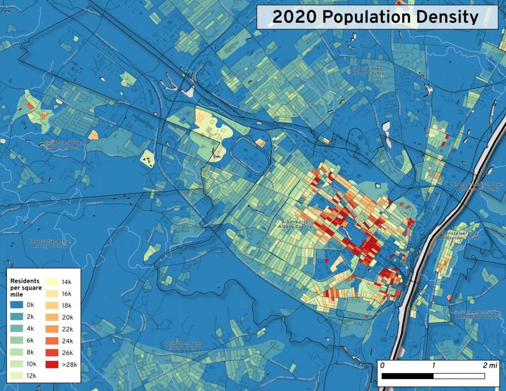
This map shows the use of 2020 PL 94-171 data to calculate population density in City of Albany.


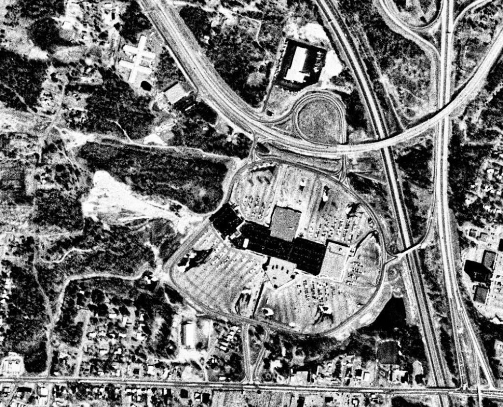
This 1985 aerial photo shows Crossgates Mall prior to it’s expansion.


This GIF image shows the change in unemployment during Coronavirus panademic.

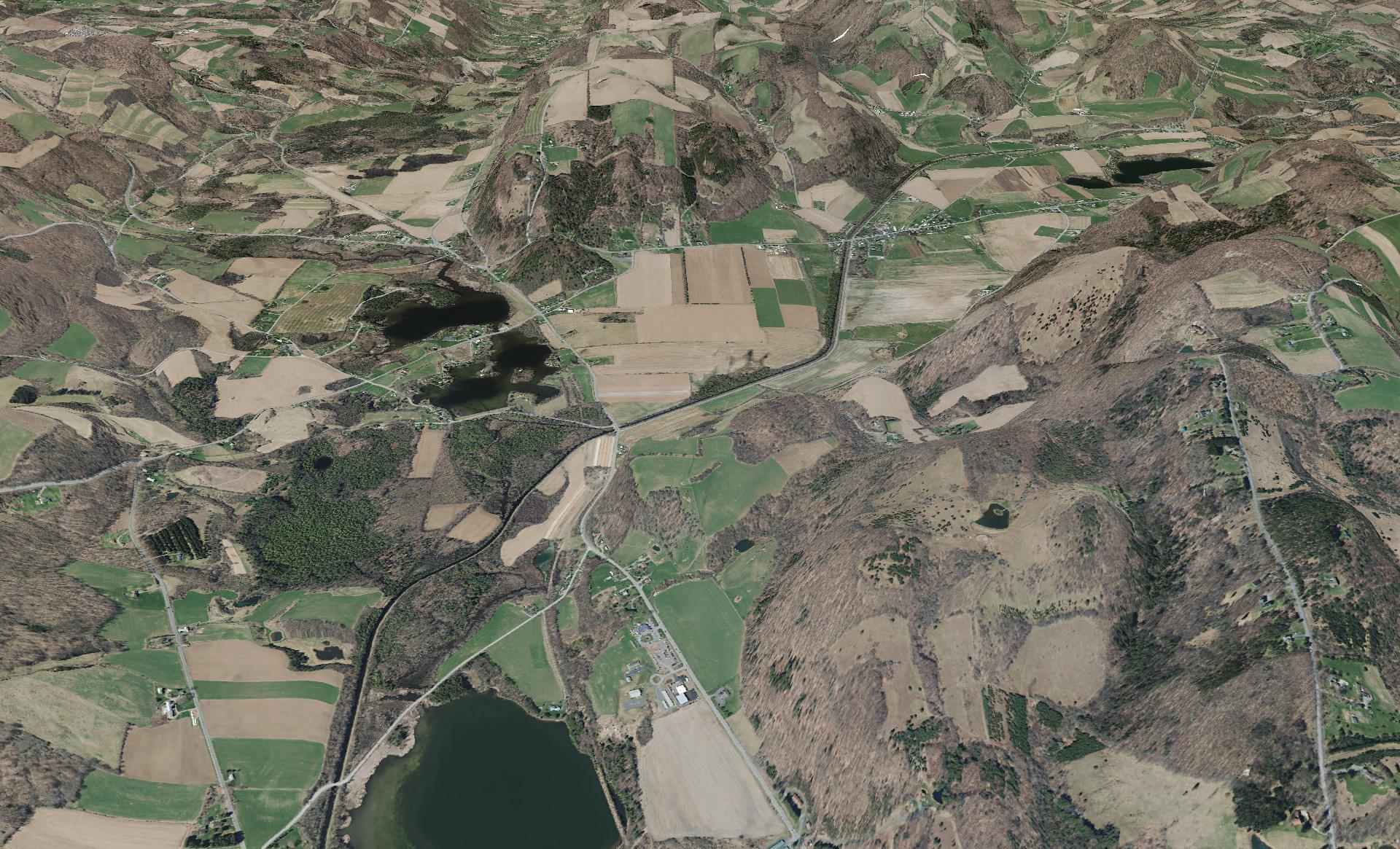
This image shows hiking trails near Brooktrout, Falls Pond and Deep Lake.


Peebles Island, a Comparison 1952


3D Interactive of campsites at Moose River Plains.


Sample tax map in Albany.


Election results – 2020 Presidential Election, Onondoga County.


Map showing where sparklers are legally sold in New York.


Downtown Plattsburgh 1866 Beers (1866 Beers vs. 2020 OSM)


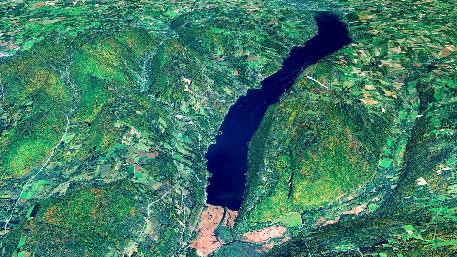
3D Rendering of Canandaigua Lake


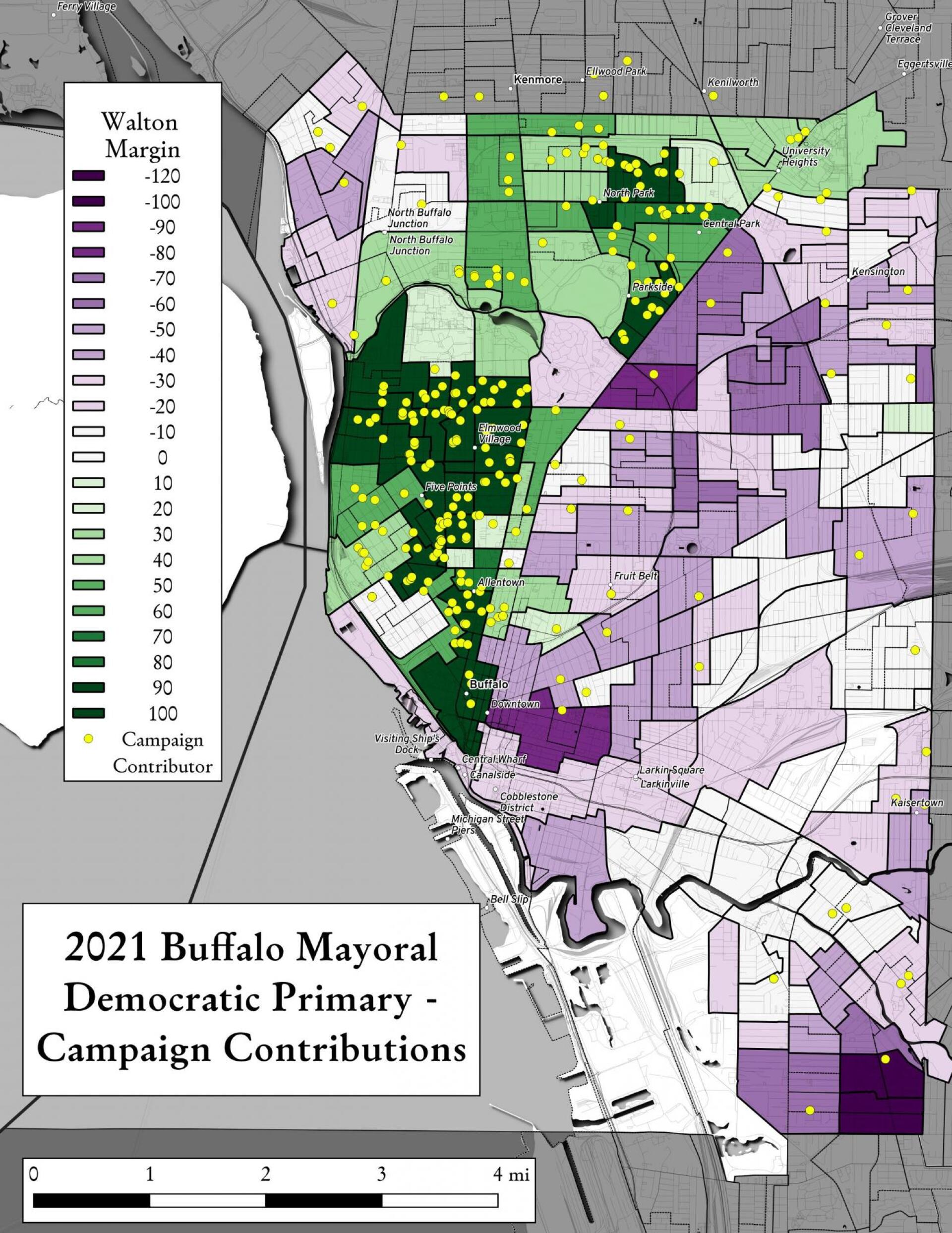
Map showing Buffalo Mayoral Primary results and campaign donors.


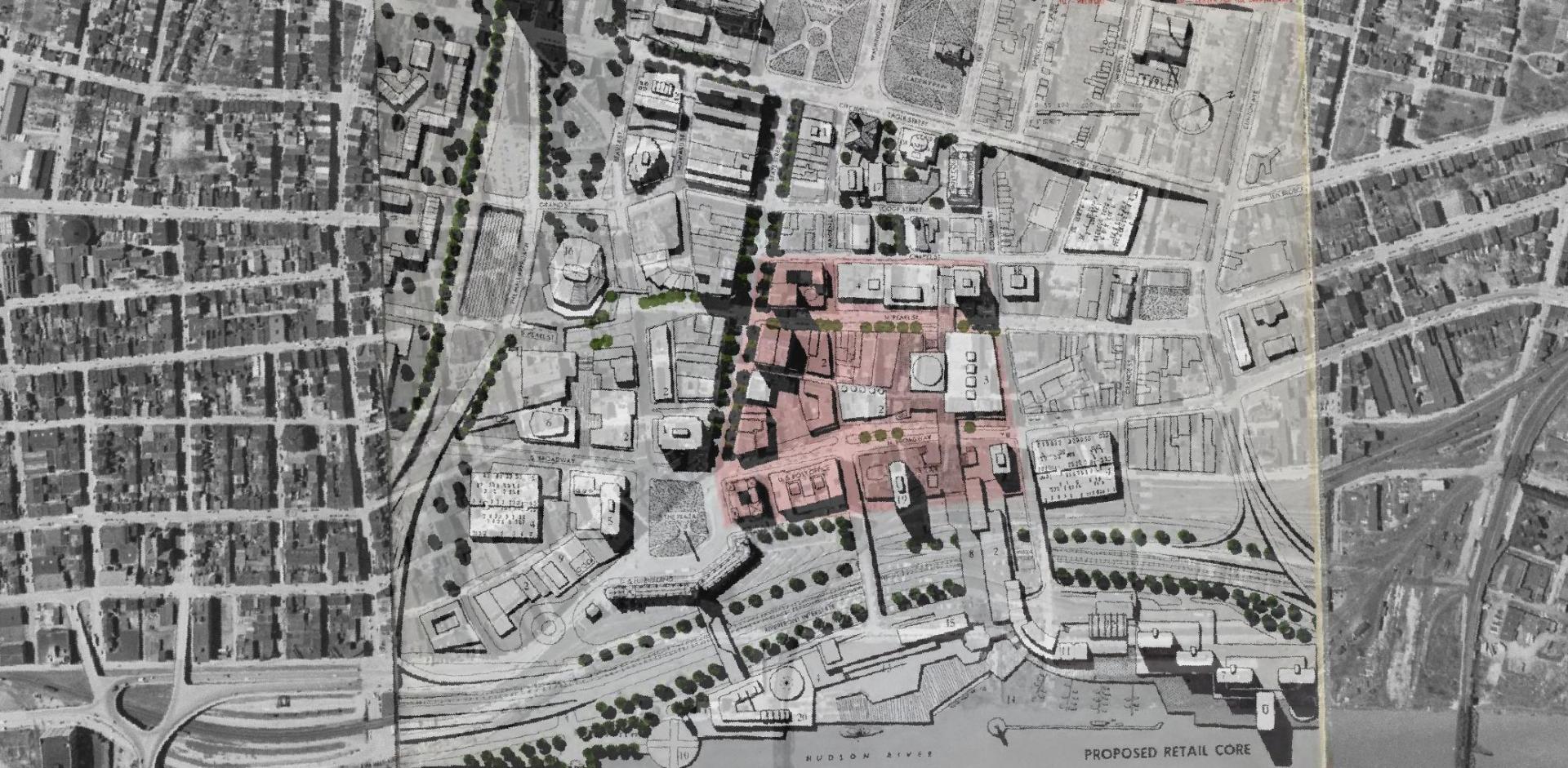
Overlay of Proposed Retail Core in 1963 Plan for the Capital City.


Map showing Local Area Unemployment Statistics – April 2020.


Interactive tax map in Delmar


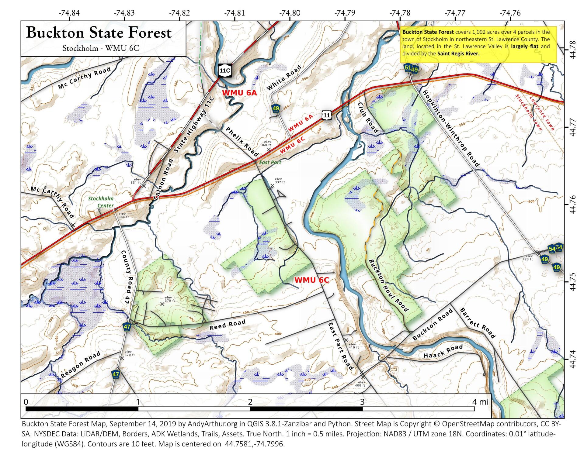
State Land in Stockholm, NY – Buckton State Forest.


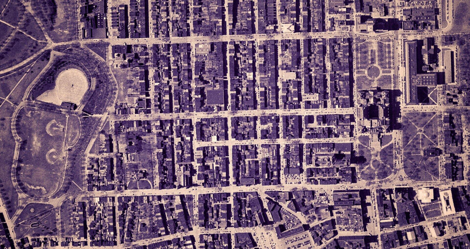
Empire State Plaza take area, 1952


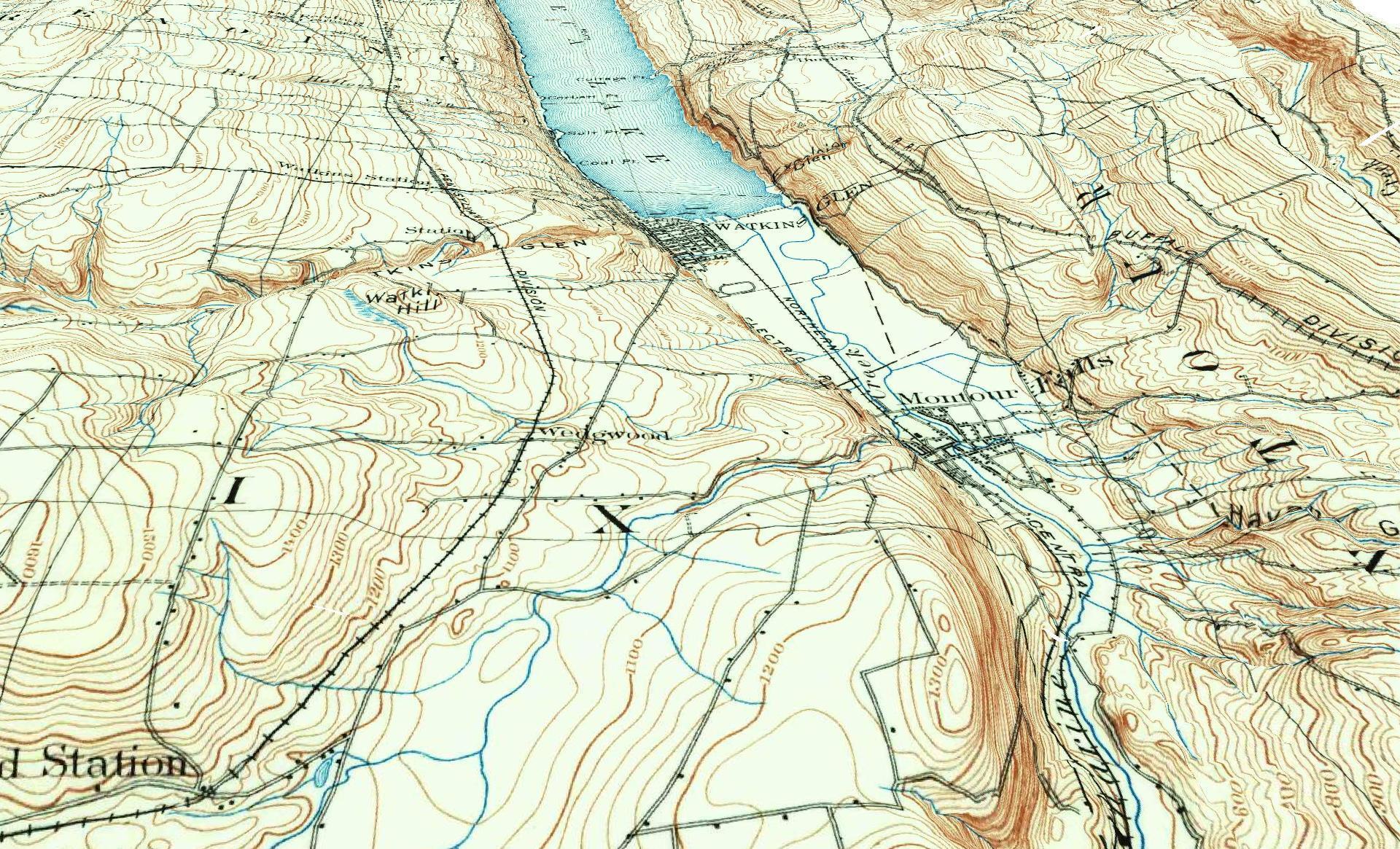
3D Rendering of the 1898 Watkins Glen Topographic Map

Examples of Data and Code

Properties in Albany Pine Bush Study Area,Excel Files: Various Tax Rolls,Find coordinates and political districts,Look Up State Tax Records and aScript for Processing RPTL 1520 PDFs.

Querying state property database, political enrollments, PL 94-171 Census files, calculating population statistics, what address is a district in, converting old districts to new districts.
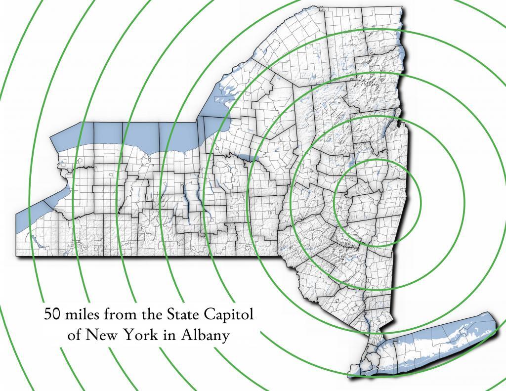
Miles from Albany millions population
50 1.002
100 1.750
150 3.511
200 17.102
250 17.725
300 18.699
350 19.411
400 20.187
450 20.201
import pandas as pd
import geopandas as gpd
 
# path to overlay shapefile
overlayshp = r'/tmp/dis_to_albany.gpkg'
 
# summary level -- 750 is tabulation block, 150 is blockgroup
# large areas over about 50 miles much faster to use bg
summaryLevel = 150
#summaryLevel = 750
 
# path to block or blockgroup file
if summaryLevel == 150:
    blockshp = r'/home/andy/Documents/GIS.Data/census.tiger/36_New_York/tl_2020_36_bg20.shp.gpkg'
else:
    blockshp = r'/home/andy/Documents/GIS.Data/census.tiger/36_New_York/tl_2020_36_tabblock20.shp.gpkg'
 
# path to PL 94-171 redistricting geoheader file
pl94171File = '/home/andy/Desktop/nygeo2020.pl'
 
# field to categorize on (such as Ward -- required!)
catField = 'Name'
 
# geo header contains 2020 census population in column 90 
# per PL 94-171 documentation, low memory chunking disabled 
# as it causes issues with the geoid column being mixed types
df=pd.read_csv(pl94171File,delimiter='|',header=None, low_memory=False )
 
# column 2 is summary level 
population=df[(df.iloc[:,2] == summaryLevel)][[9,90]]
 
# load overlay
overlay = gpd.read_file(overlayshp).to_crs(epsg='3857')
 
# shapefile of nys 2020 blocks, IMPORTANT (!) mask by output file for speed
blocks = gpd.read_file(blockshp,mask=overlay).to_crs(epsg='3857')
 
# geoid for linking to shapefile is column 9
joinedBlocks=blocks.set_index('GEOID20').join(population.set_index(9))
 
# store the size of unbroken blocks
# in case overlay lines break blocks into two
joinedBlocks['area']=joinedBlocks.area
 
# run union
unionBlocks=gpd.overlay(overlay, joinedBlocks, how='union')
 
# drop blocks outside of overlay
unionBlocks=unionBlocks.dropna(subset=[catField])
 
# create population projection when a block crosses
# an overlay line -- avoid double counting -- this isn't perfect
# as we loose a 0.15 percent due to floating point errors
unionBlocks['sublock']=unionBlocks[90]*(unionBlocks.area/unionBlocks['area'])
 
# sum blocks in category
unionBlocks=pd.DataFrame(unionBlocks.groupby(catField).sum()['sublock'])
 
# rename columns
unionBlocks=unionBlocks.rename({'sublock': '2020 Census Population'},axis=1)
 
# calculate cumulative sum as you go out each ring
unionBlocks['millions']=unionBlocks.cumsum(axis=0)['2020 Census Population']/1000000
 
# each ring is 50 miles
unionBlocks['miles']=unionBlocks.index*50
 
# output
unionBlocks

Land use in town of Berne (from 2016 National Land Cover Dataset)

Most highly assessed properties in Albany County …

from arcgis.features import FeatureLayer
lyr_url = 'https://gisservices.its.ny.gov/arcgis/rest/services/NYS_Tax_Parcel_Centroid_Points/MapServer/0'
layer = FeatureLayer(lyr_url)
query_result1 = layer.query(where="COUNTY_NAME='Albany' AND FULL_MARKET_VAL > 100000000", 
                                    out_fields='PARCEL_ADDR,CITYTOWN_NAME,FULL_MARKET_VAL,OWNER_TYPE', out_sr='4326')

df=query_result1.sdf.sort_values(by='FULL_MARKET_VAL', ascending=False)
df['Full Market Value'] = df['FULL_MARKET_VAL'].map('${:,.0f}'.format)

df
 OBJECTIDPARCEL_ADDRCITYTOWN_NAMEFULL_MARKET_VALOWNER_TYPESHAPEFull Market Value
112665264 Eagle StAlbany12042549252{β€œx”: -73.75980312511581, β€œy”: 42.650469918250…$1,204,254,925
391501200 Washington AveAlbany8862987152{β€œx”: -73.81092293494828, β€œy”: 42.679257168282…$886,298,715
4102081400 Washington AveAlbany6423982872{β€œx”: -73.82369286130952, β€œy”: 42.685845700657…$642,398,287
0885251 Fuller RdAlbany4400428272{β€œx”: -73.83559002316825, β€œy”: 42.690208093507…$440,042,827
518164632 New Scotland AveAlbany3775682018{β€œx”: -73.80381341626146, β€œy”: 42.655758957669…$377,568,201
1906141 Fuller RdAlbany3211991432{β€œx”: -73.83323986150171, β€œy”: 42.693189748928…$321,199,143
19108087See Card 1067Watervliet2808988761{β€œx”: -73.70670724174552, β€œy”: 42.719628647232…$280,898,876
1565380737 Alb Shaker RdColonie2639161003{β€œx”: -73.80365248218001, β€œy”: 42.747956678125…$263,916,100
921923304 Madison AveAlbany2342654182{β€œx”: -73.76227373289564, β€œy”: 42.648000674457…$234,265,418
2907201 Fuller RdAlbany2034261242{β€œx”: -73.83362605353057, β€œy”: 42.692609131686…$203,426,124
1669999515 Loudon RdColonie1660656008{β€œx”: -73.74958475282632, β€œy”: 42.719321807666…$166,065,600
72059247 New Scotland AveAlbany1622763388{β€œx”: -73.77597163421673, β€œy”: 42.653565689693…$162,276,338
620574132 S Lake AveAlbany1462963602{β€œx”: -73.77970918544908, β€œy”: 42.654390366929…$146,296,360
820597113 Holland AveAlbany1434985012{β€œx”: -73.77306688593143, β€œy”: 42.650762742870…$143,498,501
1778203MannsvilleColonie1425704001{β€œx”: -73.71245452369443, β€œy”: 42.718124477080…$142,570,400
18955091 Crossgates Mall RdGuilderland1305547008{β€œx”: -73.84702700595471, β€œy”: 42.687699053797…$130,554,700
102452186 S Swan StAlbany1284364032{β€œx”: -73.75980563770365, β€œy”: 42.653931892804…$128,436,403
13468831916 US 9WCoeymans1100000008{β€œx”: -73.83388475575597, β€œy”: 42.488730743021…$110,000,000
1235152380 River RdBethlehem1052631588{β€œx”: -73.76445503554325, β€œy”: 42.595925419330…$105,263,158
146509715 Wolf RdColonie1019672138{β€œx”: -73.81423716588279, β€œy”: 42.709939498581…$101,967,213
Categories:

Site Map

🌲🌲 Our Public Lands 🌳🌲

Interactive maps with backcountry and roadside camping: New York, Pennsylvania, West Virginia & Vermont.
List of NYS DEC Lean-Tos with map coordinates. List of NYS DEC Firetowers with map coordinates and more information.
Google Spreadsheet with Roadside, Primitive and Pay Campsites

Explore the Finger Lakes Trail, Long Path, Northville-Placid Trail and Long Trail/Appalachian in Vermont.
Catskill Park Mountain Peaks, Hudson Valley & Long Island Peaks, Peaks Over 3000 ft Elevation, Highest Peaks in Adirondacks, Interactive Map of All Named Summits in NYS, Blaze Colors in Catskill Park, Trailhead Parking Coordinates and Addresses in the Catskills.

Browse USGS Topo Quads as PDF πŸ†• by State Lands or County. You can Bulk Download New & Old USGS Topograpic Maps.

Links to various NY State Land Websites πŸ†•. Get latest GIS Data from state Web Services.
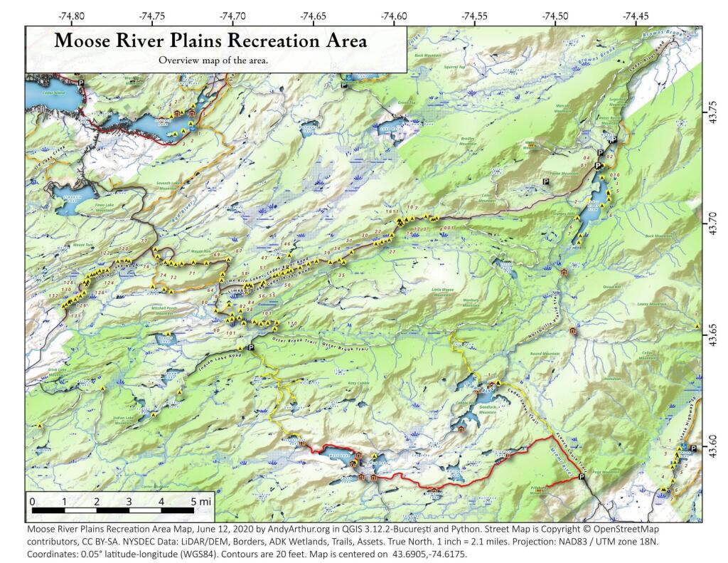
β›ΊπŸŒ² Camp πŸŒ²πŸ•

Moose River PlainsCampsite Listing, Maps and photos of state’s largest free camping area.
Piseco-Powley RoadCampsite Listing, Maps and photos of 15 mile dirt road with camping.
Catskill Park Primitive CampsitesAn overview of free camping locations in Catskill Park.
Burnt-Rossman Forest, Cattaraugus County, East Branch Sacandaga River, Finger Lakes National Forest, Madison County, Pennsylvania, Vermont and West Virigina.

Campsite Coordinates for Bog River Flow / Lows Lake, Hudson River SMA (Buttermilk Falls), Lake Lila, Oswegathie River, Nine-Corner Lake, Pharaoh Lake Wilderness, Saranac River Campsites, Stillwater Lake, Schoharie County, and Sugar Hill State Forest.

Overview of Camping Areas in the Catskills, Green Mountains, Southern Adirondacks, Central Adirondacks, Northern Adirondacks, Allegheny National Forest and Penna. DCNR Motorized Campsites and the Monongahela National Forest West Virginia.

Free Campsite Overview Maps: Adirondack – North Country, Catskills, Central NY, Finger Lakes, Western NY. Interactive Map.

Places I camped in 2023, 2022, 2021 and 2020.

🏞 πŸ›Ή Bicycle Trails and “Blackie” My Mountain Bike 🚲 🚢

Finally bought a mountain bike, after chewing over a mountain vs commuter bike. Really enjoying riding my bike to work and when it rains there is always a bike rack to safely take it back home. One way to get to adventures at Thacher Park is the Nature Bus.

Empire Trail – KMZ and Interactive Map. Parking along it.

More Trailways with KMZ files including the Albany County Rail Trail, Black Diamond Trail, Catharine Valley Trail, Catskill Scenic Trail, Fonda, Johnstown & Gloversville Rail Trail, Genesee Valley Trail, Link Trail.

🦌🌲 Hunt πŸ¦ƒπŸΏ

Wildlife Management Units (Deer)KMZ Map shows the WMU boundaries.

Summer 2019 Aerial Photographs of WMUs

KMZ Maps of Deer Harvest Density by Town: 2019, 2018, 2017, 2016. By WMU 2017, 2016, 2015.

KMZ Maps of Buck Harvest Density by Town: 2019, 2018, 2017, 2016. By WMU 2017, 2016

2016 -2019 Deer and Buck Harvest by TownKMZ Spreadsheet with FIPS codes for making your own calculations.

🎣🐑 Fish 🐟🐠

Parking and Access to Trout StreamsAn interactive, downloadable KMZ Map.
Lakes with DEC Contour MapsA KMZ Map links to Contour Maps for Fishing.

πŸŒ¨πŸ” Sled & Wheel πŸš™β„

State Truck Trails Over A Half MileDirt roads to explore in the backcountry.
NYS Statewide Snowmobile Trail SystemState trails on public and private lands.

πŸ“‰πŸ“Š Learn πŸ’΅πŸ“ˆ

Interactive Maps of NY CensusExplore and download KML files.
Charts and Interactive DiagramsFrom population to pollution control.
Andy Arthur GitHubGit my R and Python scripts used to make maps and diagrams.
Use ArcPullR to Get Geospatial DataSuper easy way to connect to get GIS data in R from government servers.
GDAL Opens E00 FilesMost open source programs nowadays can open common geospatial formats.
NY Building FootprintsWhere to find on the internet for making maps.
WMS and ArcMap ServicesDownloadable CSV file listing services used on the blog.
2022 US Census Population EstimatesRed states, south continue to gain population.
2020 Cartogram of State Population

πŸ’³ πŸ› Property Taxes πŸ πŸ’Έ

Properties in Albany Pine Bush Study Area, Excel Files: Various Tax Rolls, Find coordinates and political districts, Look Up State Tax Records and a Script for Processing RPTL 1520 PDFs. Match NY SWIS Codes to FIPS Codes and GEOID

πŸš—πŸš— Big Red πŸš—πŸš—

Big RedPhotos and Videos of my lifted truck with its camper shell. Big Red’s Dual Battery Setup for Camp Power, Video Tour and Diagram. Big Red is getting old. What is next? I’ve thought about going carless for a while to save money and reduce pollution. Or maybe going bigger? Or smaller? Five dollar gas sucks.

πŸ”₯🌲 Off-Grid Living 🏠🀠

I am seriously thinking about building an off-grid house. I have a first draft. I need to learn CAD! I have a road map towards buying land and building. I concede might have to live with long commute and give up traveling and camping. I need to be strong.

Why off grid? Well, I’m not into contemporary society. I want to own land, but not be called a landowner, and a cabin, not hooked to electrical grid, farm, raise pigs for food and burn my own trash. I’m saving for a better tomorrow, hoping to make the leap to another freer state. Having acreage is important. Cornfields aren’t bad neighbors. Maybe though my vision has grown smaller and more local. More on off-grid living.

I am 16 years into my career and have made some significant progress in my life. I love my job. But I do wonder on all the things I’m missing out but saving sure makes me high. Maybe it will be different when I own my own land — the end of goal of all this saving.

2020 into 2021 during the pandemic was a year of remote work. It was a struggle not having internet at home, worked a lot out of my truck. But I worked remotely from Horseshoe Lake which was super cool.

Generally I like the idea of owning land in a red state, particularly Idaho, Iowa, Pennsylvania, West Virginia, Wisconsin — and Midwest more generally. But I may settle for New York – it’s all about the f-ing money!

πŸ’»πŸ‘¨β€πŸ’» Open Source πŸ—ΊοΈπŸ“

I use open source software and public sources of data for the blog. Quantum GIS (QGIS), GDAL/ogr2ogr, PyQGIS, GeoPANDAS, R Studio and Leaflet for map making, Arduino and ESP32 microprocessors, Ubuntu Linux and XFCE Window Manager. I’ve recently gotten interested in machine learning.

I avoid using commercial software like Microsoft Windows and do not have home internet or television. If you don’t use commercial software and use your brain, fears of computer viruses are overblown. I deleted most of my social media accounts.

Creating Digital Surface Models using LiDAR Point Clouds.

πŸ“ŠπŸ—Ί R Statistical Programming πŸ“œπŸ‘¨β€πŸ«

The R programming language and RStudio are powerful tools for statistical analysis, making maps and charts. Many of the blog posts and analysis I do are in R, ggplot not only makes great charts but also maps using tidycensus. Generally, R is better then Python for geospatial work.

Use IDW Interpolation to fill in missing Census data, Zonal Histograms for land cover, load WMS Aerial Photography in R, find mountain peaks, save Census shapefiles using tigris quickly, pull NY Election Night Results using Selenium. Fast reverse Geocoding in PostGIS. Working with PDFs in R. Fix a common error starting rselenium/wdman. Make data-filled calendars. R is wonderful and weird, learn it!

πŸΌπŸ”’ Python and Pandas πŸ’»πŸ

Querying state property database, political enrollments, PL 94-171 Census files, calculating population statistics, what address is a district in, converting old districts to new districts, Shapefiles missing Projection information in QGIS.

Learn to code for free modern HTML, Javascript, Python and SQL at freeCodeCamp and web development at the Odin Project.

🐴 🐘 Politics 🦁 🐍

Crunched Election Results with Turnout for Albany County: November 2023, 2022, 2021, 2020, 2019 and Primaries June 2019, Pres/June 2020, June 2021, June 2022, Aug 2022, June 2023.

Albany County Races converted to the new 2023 EDs using Super EDs and Code: 2022, 2021, 2020, 2019 and Primaries June 2019, Pres/June 2020, June 2021, June 2022, Aug 2022.

Above Election Results as zipped Excel files.

Albany County Legislature Districts 2024 Maps

Maps Comparing 2017 and 2023 Albany County Election Districts and a Crosswalk Table Showing the Proposition of Voting Age Population in New and Old EDs

Maps of 2022 NYC Assembly Races, NYS Assembly Races, NY Senate Races, Governor’s Race in Erie County and Statewide. Partisan shift in governor race between 2010 and 2018.

A comparison of Democratic Performance 2022 Assembly Districts to those proposed in 2023 by the IRC. Here is latest 4/20/23 IRC Maps, showing ADP and how they change from existing Assembly districts. Most towns upstate, outside of cities, are quite red. Using LATFOR data with R to calculate Average Democratic Performance.

You can scrape employee salary data from SeeThroughNY using R. Other useful investigative resources.

I often think politics is for losers. I’m into the politics of statistical analysis and reading history books.

I believe strongly in the first amendment, second amendment, oppose gun restrictions and I support de-funding the police in favor of lower-cost technology and civilian employees. Maybe use red flag laws for voting to stop dangerous voters? And the media should stop promoting mass-shootings, even if it’s super profitable for all involved. They should tax the media when it promotes violence. I think some people are much too paranoid in politics. How elections are rigged under law to benefit incumbents. But vote, it’s the best option and inexpensive.

Yeah for the third parties! I voted for Larry Sharpe for Governor and Jo Jergenson for President but my views are complicated and often vote for Democrats, after voting Jill Stein Green Party in 2016.

Generally, I think Biden has been a good change over DJT and glad the Trump era is over and are glad prosecutors and grand jurors are holding him responsible by indicting him for many serious felonies. I don’t think Trump can win in 2024, as nothing has changed politically from 2020.

I think rural people should be left alone and not worship government workers or have parades for them. I am no fan of Donald Trump, his speeches are bad, I don’t like Trump’s embrace of radical environmentalists, but do admire the homemade roadside monuments to DJT.

I don’t toke. But whatever. There are too many transit authorities.

🌲🌳The Earth 🌎 🐸

Why I oppose wilderness areas and parks. It’s trendy to be green these days, but is eco-marketing good for the planet? I visited the Mount Storm Coal Plant and Corridor H.

I worry about a lot about overly-aggressive Climate Change Action, and Undermining Environment Laws for Climate Action. I think we should all admit we are Addicted to Fossil Fuels. These days, urban recycling has become a joke, when it’s still an option at all. It’s better to just buy less shit and avoid the alure of Costcos. I really don’t like how aging radicals have become industrial solar salespeople.

Big bucks are coming to state-designated disadvantaged communities under the CLCP. Which counties and political districts are in line for the the most pork? Interactive map.

I’m a big of farmers who are essentially Living Off the Earth and think Rednecks are Noble Savages. Dairy Farming are key to our rural landscape. I’d trust a farmer or a hunter in a pile of guts he’s butchered over any ivory-tower scientist.

πŸŒŽπŸ”† Industrial Solar 🌞 🏭

Hundreds of multi-acre industrial solar farms are being built in our state. How bad is solar for the environment? We should ask tough questions. Interactive of recently built solar farms, proposed facilities. List of proposed industrial solar facilities. See how the Greenville Solar Farm changed the landscape.

πŸ’³ πŸ’ΈSaving Money πŸ’° πŸ’·

I am not a fan of ESG Investing as it’s not well diversified. I prefer index-funds and other tax-advantaged ways of saving. Why I am concerned about saving enough for retirement, even though I’m in my late 30s. We as a nation should save more, consume less. I like the idea of carbon tax to replace capital gains taxes to discourage consumption.

πŸ₯¦ 🍎Mission Fifty & Being Healthier 🏠🧠

I am now officially in my 40s! I am building to a better life in my 50s, which means getting up early, walking a lot, saying no to cake and yes to more fruit. In many ways, the forties are an awesome time to be alive.

And eating healthy for less without losing sleep over arsenic. And I don’t think we should subsidize unhealthy habits. How I got started in eating healther. Meals are too focused on meat and carbs due to how we describe them, maybe I eat too many bananas in the office, what to eat while camping, worry more about salt then GMOs, eat more beans. Do spend extra for farmers market peaches, especially doughnut peaches and plums. Consider ethnic supermarkets. Thinking about how to make a healthier macaroni and cheese, spinach-mackeral-pasta salad, quick-cook biscuits and whole-wheat bread. That said, too many recipes are junk food crap. Okay in moderation is not okay. The fact that I’m thinner is not a sign I’m dying.

A few years back I decided to explore my mental illness with therapy, thinking about why I have so much anxiety and how many of my values are rational or just thinking too much rednecks’ burn barrels and how much of a throwaway society we live in. Do I want to change?

I’ve learned to care less about the world, and focus more on myself. Maybe I am happier as I am now, saving and investing a lot towards owning my own land, where I don’t have to deal with all the bullshit of modern life.

Mission Fifty: Getting to the point where I own my own land. 🚜
Healthy Eating 🍎 / Growing My Wealth πŸ’°
Healthy Thoughts πŸ’­ / Enjoying Life πŸ˜ƒ

Questions, comments? Feel free to email me at andy@andyarthur.org.

You do your thing, I’ll do mine.

I use GNU open source software.
Plus I like buck goats,
because they’re real macho men
spraying their beards with goat urine.

March is upon us. Get out, enjoy it, be safe with fire and burning shit, and remember soon enough black flies are waiting.” – Andy Arthur

Return to the Top

Laugh a bit and learn how your data is used on this blog: Privacy Policy

This blog is Β© Copyright 1997-2023 Andy Arthur.org, please share using the Creative Commons Attribution 3.0 License.

Categories:

Moose River Plains Campsites

Interactive Map of Lean-Tos and Campsites

An overview map and list of campsites and their locations at the Moose River Recreation Area.

 Moose River Plains Recreation Area

Maps

Campsites

Milepoint Name Feature Notes Access Location
Cedar River Flow 1 Cedar River Flow Tent site on flow Boat 43.702924803151, -74.4871304116533
Cedar River Flow 2 Cedar River Flow Tent site on flow Boat 43.7104737708879, -74.4802343768254
Cedar River Flow 3 Cedar River Flow Tent site on flow Boat 43.7145237017622, -74.4679264444554
Cedar River Flow 5 Cedar River Flow Tent site on flow Boat 43.7111711590583, -74.4675178486588
Cedar River Flow 6 Cedar River Flow Tent site on flow Boat 43.7084767866376, -74.4717703157492
Beaver Lake Campsite Beaver Lake Site overlooks Beaver Lake Hike 43.6516613421651, -74.7407833400961
81 Icehouse Pond Accessible site at Icehouse Pond with privy Hike 43.6646602166505, -74.7029502913239
140A Indian Lake Campsite on Indian Lake, outhouse in bad condition Hike 43.6154753632731, -74.7499942080732
East of Muskrat Pond Indian Lake Trail Former roadside campsite, largely abandoned Hike 43.645116528704, -74.696221627206
46 Lost Ponds Trail Beyond the end of current Lost Ponds Road Hike 43.6868179572109, -74.6655581886723
47 Lost Ponds Trail Above Lost Ponds Hike 43.6859472953826, -74.6722052916864
Mitchell Pond 1 Mitchell Pond Tent site, bushwhack Hike 43.6729475881673, -74.7502538624373
Mitchell Pond 2 Mitchell Pond Tent site, bushwhack Hike 43.6716991892117, -74.7432124817486
64A Mitchell Pond (Accessible Campsite at End of Gravel Trail) Gravel path to site, wildrness privy Hike 43.6706136251028, -74.7387363015355
10 89 Beaver Lake Road Off Otter Brook Road, Sand Plains Vehicle 43.6583112347181, -74.7012491214803
11 90 Beaver Lake Road Off Otter Brook Road, Sand Plains Vehicle 43.6577446555162, -74.7038760912165
16 1 Cedar River – Limekiln Lake Road Driveway Along Tributary of Silver Run Vehicle 43.7033162602551, -74.5742148239156
16 3 Cedar River – Limekiln Lake Road Along Silver Run Vehicle 43.7027301523306, -74.5757742464803
16 4 Cedar River – Limekiln Lake Road Along Silver Run, driveway at Sharp S Turn Vehicle 43.7026421104662, -74.5769731929134
16 7 Cedar River – Limekiln Lake Road Along Silver Run Vehicle 43.7040070126376, -74.5809411044503
15 10 Cedar River – Limekiln Lake Road Old gravel pit, accessible Vehicle 43.7031498027862, -74.5893864145496
15 11 Cedar River – Limekiln Lake Road Across from 12 Vehicle 43.702458607149, -74.5926546451668
15 12 Cedar River – Limekiln Lake Road Across from 11 Vehicle 43.7028667147947, -74.5929833340894
15 13 Cedar River – Limekiln Lake Road Along Silver Run Vehicle 43.7010402113051, -74.5956355707995
15 14 Cedar River – Limekiln Lake Road Along Silver Run Vehicle 43.7010328498576, -74.597457469967
14 16 Cedar River – Limekiln Lake Road Access Road for 16/17/18 Group Vehicle 43.7025294616695, -74.5969885248639
14 17 Cedar River – Limekiln Lake Road Access Road for 16/17/18 Group Vehicle 43.7021028692463, -74.5966599329259
14 18 Cedar River – Limekiln Lake Road Access Road for 16/17/18 Group Vehicle 43.7023846304313, -74.5978818600647
14 19 Cedar River – Limekiln Lake Road Along Silver Run Vehicle 43.7003546491841, -74.5964872856253
14 21 Cedar River – Limekiln Lake Road Across road from Silver Run Vehicle 43.6957217888458, -74.6020563094081
13 22 Cedar River – Limekiln Lake Road Across road from Silver Run Vehicle 43.6935817523545, -74.6036764840587
13 27 Cedar River – Limekiln Lake Road Across road from Silver Run Vehicle 43.6926540634024, -74.6082201775478
13 30 Cedar River – Limekiln Lake Road Open Area in Woods Vehicle 43.6918525577623, -74.6118452191364
13 31 Cedar River – Limekiln Lake Road Near Marsh off Silver Run Vehicle 43.6881856235873, -74.6271629609656
12 34 Cedar River – Limekiln Lake Road Open Field Near Old Sly Pond Road Vehicle 43.6846954329325, -74.634678249126
12 35 Cedar River – Limekiln Lake Road Former Sly Pond Road Vehicle 43.6836690328942, -74.6318552827363
11 38 Cedar River – Limekiln Lake Road On Hill Overlooking Road, near start of Lost Ponds Area Vehicle 43.6836029270341, -74.6401393590772
11 39 Cedar River – Limekiln Lake Road Above CRLLR, start of Lost Ponds Area Vehicle 43.6841476346233, -74.6487511980121
11 40 Cedar River – Limekiln Lake Road Above CRLLR, start of Lost Ponds Area Vehicle 43.682942162164, -74.6537793571789
11 41 Cedar River – Limekiln Lake Road Above CRLLR, start of Lost Ponds Area Vehicle 43.681311345096, -74.6589116717693
10 42 Cedar River – Limekiln Lake Road Above CRLLR, start of Lost Ponds Area Vehicle 43.6799039050817, -74.6646031695507
10 43 Cedar River – Limekiln Lake Road Above CRLLR, start of Lost Ponds Area Vehicle 43.6793727911294, -74.6664156654099
10 44 Cedar River – Limekiln Lake Road West of Lost Ponds Road, Sand Plains Vehicle 43.678808787762, -74.6696555368193
10 50 Cedar River – Limekiln Lake Road West of Lost Ponds Road, Sand Plains Vehicle 43.677986610504, -74.6732025802129
10 51 Cedar River – Limekiln Lake Road Pull-Off, Small Site, Sand Plains Vehicle 43.6775108499728, -74.6750146421403
10 52 Cedar River – Limekiln Lake Road Old gravel pit, short loop below CRLLR Vehicle 43.6748840847288, -74.6815273754233
10 53 Cedar River – Limekiln Lake Road Access Road for 55/54/55 Group, Sand Plains Vehicle 43.6733317629897, -74.6820452615144
10 54 Cedar River – Limekiln Lake Road Access Road for 55/54/55 Group, Sand Plains Vehicle 43.673268538603, -74.6822820352903
9 55 Cedar River – Limekiln Lake Road Access Road for 55/54/55 Group, Sand Plains Vehicle 43.6733705968856, -74.6827076379887
9 56 Cedar River – Limekiln Lake Road Driveway, East of Former Dump, Sand Plains Vehicle 43.673126585883, -74.6891475571674
9 57 Cedar River – Limekiln Lake Road Has Trail to Moose River Vehicle 43.6736673106707, -74.6902687046523
8 64 Cedar River – Limekiln Lake Road Near Mitchell Pond Trail Vehicle 43.6757521870177, -74.707500815672
8 66 Cedar River – Limekiln Lake Road Near Pine Creek Vehicle 43.6784203854214, -74.7068492021325
7 67 Cedar River – Limekiln Lake Road Benedict Creek Road, Wooded Vehicle 43.6851041444828, -74.7031887110586
7 69 Cedar River – Limekiln Lake Road Remote site, perched over the road Vehicle 43.6834516958835, -74.7168906980223
6 70 Cedar River – Limekiln Lake Road Large loop off of CRLLR Vehicle 43.6839906014562, -74.7249870178447
6 71 Cedar River – Limekiln Lake Road Very sandy site near Mitchells Pond Upper Loop Vehicle 43.6833776353921, -74.7321947941391
5 72 Cedar River – Limekiln Lake Road At end of Bear Pond Loop Road (Accessable) Vehicle 43.6828956047277, -74.7359084701559
4 73 Cedar River – Limekiln Lake Road Very sandy site near Mitchells Pond Upper Loop Vehicle 43.6835777053685, -74.7387188889593
4 74 Cedar River – Limekiln Lake Road On a hill overlooking road and marshy area Vehicle 43.6839187521201, -74.742285779317
4 76 Cedar River – Limekiln Lake Road Very sandy site near Mitchells Pond Upper Loop Vehicle 43.6864452702399, -74.7471689344191
4 77 Cedar River – Limekiln Lake Road Near Red River, Bear Pond Loop, Sand Plains Vehicle 43.6897961458669, -74.7484803840413
10 58 Helldiver Pond Road Near Helldiver Pond Vehicle 43.6735979105991, -74.6920316000423
10 59 Helldiver Pond Road Near Helldiver Pond Vehicle 43.6723766419894, -74.6929318681131
10 60 Helldiver Pond Road Near Helldiver Pond Vehicle 43.6713193532923, -74.692758456613
10 61 Helldiver Pond Road Accessible site at end of Helldiver Pond Road Vehicle 43.6705019900204, -74.6921751440693
15 West of Brooktrout Trail Indian Lake Road Past Brooktrout Trail, on a hill over road Vehicle 43.6254538914434, -74.7337300739322
10 48 Lost Pond Road Sand Plains, Marshes Aroubnd Vehicle 43.6814268347573, -74.6667101324338
11 49 Lost Pond Road Sand Plains, Marshes Aroubnd Vehicle 43.6819456385478, -74.6670131106595
10 80 Otter Brook Road Has Trail to Moose River Vehicle 43.6620917920003, -74.7112181918076
11 98 Otter Brook Road Above Moose River on Hill Vehicle 43.6588725644731, -74.6966603409996
11 101 Otter Brook Road Sand Plains Vehicle 43.6564420559443, -74.6938956128147
11 103 Otter Brook Road Sand Plains Vehicle 43.657108724794, -74.6873446316172
12 104 Otter Brook Road Wooded Site Vehicle 43.6560617426567, -74.6832992891923
12 106 Otter Brook Road Wooded Site Vehicle 43.6565121581975, -74.6789913497265
13 110 Otter Brook Road Wooded Site Vehicle 43.6566072628101, -74.6733859460379
13 111 Otter Brook Road Near Otter Brook Bridge Vehicle 43.6539235327721, -74.6747718892435
23 1 Wakely Dam Camping Area Accessible site Vehicle (before gate) 43.7266767212397, -74.474100266424
23 2 Wakely Dam Camping Area Field Camping Vehicle (before gate) 43.7266515010084, -74.4733110730078
23 3 Wakely Dam Camping Area Field Camping Vehicle (before gate) 43.7259595122959, -74.473899965642
23 4 Wakely Dam Camping Area On Driveway to Lake Vehicle (before gate) 43.7260676922081, -74.4742326471903
23 5 Wakely Dam Camping Area On Driveway to Lake Vehicle (before gate) 43.7255637908987, -74.4741751228291
23 6 Wakely Dam Camping Area On Driveway to Lake Vehicle (before gate) 43.7252231337487, -74.4745830371916
23 9 Wakely Dam Camping Area Across bridge Vehicle (before gate) 43.726275356142, -74.4717840349063
23 10 Wakely Dam Camping Area Across bridge Vehicle (before gate) 43.7266308152758, -74.4712600272389
10 82 Otter Brook Road On Moose River Vehicle (driveway) 43.6603083771227, -74.7010353925305
11 84 Otter Brook Road On Moose River Vehicle (driveway) 43.6619962517853, -74.6957783254417
6 120 Natural Rock Dam Road Sand Plains near Red River Vehicle (Opens July) 43.6848543033273, -74.7664253595203
6 122 Natural Rock Dam Road Wooded Site Vehicle (Opens July) 43.684367353989, -74.7717171949716
6 123 Natural Rock Dam Road Wooded Site Vehicle (Opens July) 43.6804228755091, -74.7782951743141
6 124 Natural Rock Dam Road Wooded Site Vehicle (Opens July) 43.6792030487765, -74.7847972548314
7 125 Natural Rock Dam Road Wooded Site Vehicle (Opens July) 43.6783559964111, -74.7880327043169
7 126 Natural Rock Dam Road Wooded Site Vehicle (Opens July) 43.6748535298235, -74.790591643043
7 127 Natural Rock Dam Road Wooded Site Vehicle (Opens July) 43.6739776362472, -74.7910844137006
7 128 Natural Rock Dam Road Wooded Site Vehicle (Opens July) 43.6751413481917, -74.7924842843025
8 129 Natural Rock Dam Road Wooded Site Vehicle (Opens July) 43.6703784784539, -74.7926312803463
8 130 Natural Rock Dam Road Wooded Site Vehicle (Opens July) 43.6666270858056, -74.8019151989726
8 131 Natural Rock Dam Road Wooded Site Vehicle (Opens July) 43.6643581634434, -74.8054154753831
8 132 Natural Rock Dam Road Wooded Site Vehicle (Opens July) 43.6652083016168, -74.8036826184027
5 119A Natural Rock Dam Road Sand Plains near Red River Vehicle (Opens July) 43.6844716021433, -74.7646961785253
6 123A Natural Rock Dam Road Wooded Site Vehicle (Opens July) 43.6802422604152, -74.782965042166
6 124A Natural Rock Dam Road Wooded Site Vehicle (Opens July) 43.6785899888224, -74.7864319884685
6 125A Natural Rock Dam Road Wooded Site Vehicle (Opens July) 43.6776017274889, -74.7902229325712
7 126A Natural Rock Dam Road Wooded Site Vehicle (Opens July) 43.6756110574941, -74.7901645681643
8 129A Natural Rock Dam Road Wooded Site Vehicle (Opens July) 43.6689370211979, -74.7948887917477
8 129AA Natural Rock Dam Road Wooded Site Vehicle (Opens July) 43.6674497436753, -74.7980604042935
8 130A Natural Rock Dam Road Wooded Site Vehicle (Opens July) 43.6661052974262, -74.8016557609016
8 130AA Natural Rock Dam Road Wooded Site Vehicle (Opens July) 43.6669094078356, -74.8007390664074

Payne Mountain with Cedar River Flow Beyond It