Search Results for: map west kill fishing

USGS Topographic Maps – Sullivan to Yates County

Counties: Albany to Delaware / Dutchess to Livingston / Madison to Otsego / Putnam to Suffolk / Sullivan to Yates

Browse Topographic Maps: Full State / Historical USGS Topographic Maps

Sullivan County

PDF (50-60 MB Download) Historical USGS Topo Maps State Lands (Links to DEC Website) Towns (Percent of Town’s Area)
Current Callicoon GeoPDF Map
1965 Map No. 123143, 1965 Map No. 123144, 1965 Map No. 123145, 1992 Map No. 137140 Callicoon Creek North Branch Fishing Access, Crystal Lake Wild Forest, Delaware River Waterway Access Callicoon (3%), Delaware (39%), Fremont (55%), Hancock (1%)
Current Claryville GeoPDF Map
1966 Map No. 137174, 1966 Map No. 137635, 1966 Map No. 137636 Sundown Wild Forest, Willowemoc Wild Forest, Slide Mountain Wilderness, Big Indian Wilderness Denning (31%), Hardenburgh (1%), Neversink (25%)
Current Damascus GeoPDF Map
NA NA Cochecton (43%), Delaware (12%), Tusten (7%)
Current Eldred GeoPDF Map
1967 Map No. 138051, 1967 Map No. 138052 Sullivan FP Detached Parcel, Hickok Brook Multiple Use Area Bethel (3%), Cochecton (2%), Highland (43%), Tusten (61%)
Current Ellenville GeoPDF Map
1942 Map No. 138073, 1942 Map No. 138074, 1969 Map No. 137354, 1969 Map No. 137355, 1969 Map No. 138078 Ulster FP Detached Parcel, Sandburg Creek Fishing Access, Shawangunk Ridge State Forest, Roosa Gap State Forest, Painter Hill Multiple Use Area, Oak Ridge Multiple Use Area, West Branch Beerkill Fishing Access Fallsburg (0%), Mamakating (18%), Shawangunk (3%), Wawarsing (27%)
Current Grahamsville GeoPDF Map
1966 Map No. 129597, 1982 Map No. 129598 Sullivan FP Detached Parcel, Neversink River Fishing Access, Sundown Wild Forest Fallsburg (22%), Neversink (33%), Wawarsing (7%)
Current Hartwood GeoPDF Map
1966 Map No. 129830, 1966 Map No. 129831 Neversink River Unique Area Forestburgh (74%), Thompson (16%)
Current Highland Lake GeoPDF Map
1967 Map No. 129920, 1967 Map No. 137250 Sullivan FP Detached Parcel, Hickok Brook Multiple Use Area, Mongaup Valley WMA Bethel (6%), Forestburgh (15%), Highland (39%), Lumberland (38%), Thompson (3%)
Current Horton GeoPDF Map
1965 Map No. 129786, 1965 Map No. 129787, 1982 Map No. 129785 Hancock FP Detached Parcel, Crystal Lake Wild Forest Colchester (5%), Fremont (14%), Hancock (26%)
Current Jeffersonville GeoPDF Map
1965 Map No. 129990, 1965 Map No. 129991 Callicoon Creek North Branch Fishing Access Bethel (4%), Callicoon (74%), Delaware (25%), Fremont (12%), Liberty (1%)
Current Lake Huntington GeoPDF Map
1967 Map No. 130046, 1967 Map No. 137308 Lake Huntington Waterway Access Bethel (29%), Cochecton (55%), Delaware (23%), Tusten (2%)
Current Lewbeach GeoPDF Map
1965 Map No. 130250, 1965 Map No. 130251, 1965 Map No. 130253, 1965 Map No. 137316 Andes FP Detached Parcel, Murphy Hill State Forest, Delaware Wild Forest, Dry Brook Ridge Wild Forest, Little Pond Campground Andes (34%), Colchester (9%), Hardenburgh (2%), Middletown (0%), Rockland (2%)
Current Liberty East GeoPDF Map
1966 Map No. 130264, 1966 Map No. 130265 NA Fallsburg (22%), Liberty (30%), Neversink (16%)
Current Liberty West GeoPDF Map
1965 Map No. 130266, 1965 Map No. 137357, 1965 Map No. 137358 Little Beaverkill Fishing Access Bethel (3%), Callicoon (8%), Liberty (61%), Rockland (0%)
Current Livingston Manor GeoPDF Map
1965 Map No. 130296, 1965 Map No. 130297, 1965 Map No. 137365 Little Beaverkill Fishing Access, Willowemoc Creek Fishing Access, Willowemoc Creek Waterway Access, Delaware Wild Forest, Willowemoc Wild Forest, Beaverkill Campground Callicoon (3%), Colchester (2%), Liberty (3%), Rockland (51%)
Current Monticello GeoPDF Map
1966 Map No. 130634, 1966 Map No. 130635, 1966 Map No. 130636 NA Bethel (1%), Fallsburg (13%), Liberty (3%), Thompson (49%)
Current Narrowsburg GeoPDF Map
1968 Map No. 130762, 1994 Map No. 137396, 1997 Map No. 137398, 1997 Map No. 137400 NA Tusten (30%)
Current Peekamoose Mountain GeoPDF Map
1943 Map No. 128939, 1943 Map No. 128941 Sundown Wild Forest, Slide Mountain Wilderness, Big Indian Wilderness Denning (47%), Neversink (2%), Rochester (1%), Shandaken (2%), Wawarsing (0%)
Current Pond Eddy GeoPDF Map
1965 Map No. 129064, 1965 Map No. 129065, 1965 Map No. 129066, 1965 Map No. 129067, 1965 Map No. 136816, 1992 Map No. 136817, 1997 Map No. 136818 Hickok Brook Multiple Use Area, Mongaup Valley WMA Deerpark (2%), Forestburgh (0%), Highland (1%), Lumberland (56%)
Current Port Jervis North GeoPDF Map
NA Cherry Island WMA, Huckleberry Ridge State Forest, Mongaup Valley WMA Deerpark (70%), Forestburgh (3%), Greenville (3%), Port Jervis city (68%)
Current Rondout Reservoir GeoPDF Map
1969 Map No. 129207, 1969 Map No. 463445 Vernooy Kill State Forest, Sundown Wild Forest Denning (1%), Neversink (5%), Rochester (7%), Wawarsing (33%)
Current Roscoe GeoPDF Map
1965 Map No. 129208, 1965 Map No. 129209, 1965 Map No. 136874 Delaware County Scenic Resource, Colchester FP Detached Parcel, Delaware FP Detached Parcel, Beaverkill Fishing Access, Willowemoc Creek Fishing Access, Delaware Wild Forest, Willowemoc Wild Forest Callicoon (12%), Colchester (17%), Fremont (19%), Hancock (0%), Rockland (17%)
Current Shohola GeoPDF Map
NA Hickok Brook Multiple Use Area Highland (18%), Lumberland (5%)
Current White Lake GeoPDF Map
1967 Map No. 140257, 1967 Map No. 140258 NA Bethel (54%), Liberty (1%), Thompson (8%)
Current Willowemoc GeoPDF Map
1966 Map No. 137033, 1966 Map No. 140307, 1966 Map No. 140308, 1997 Map No. 137034 Willowemoc Wild Forest, Big Indian Wilderness, Mongaup Pond Campground Denning (5%), Hardenburgh (6%), Liberty (2%), Neversink (18%), Rockland (30%)
Current Woodridge GeoPDF Map
1966 Map No. 140376, 1966 Map No. 140377 Neversink River Fishing Access Fallsburg (43%), Mamakating (5%), Thompson (11%), Wawarsing (5%)
Current Wurtsboro GeoPDF Map
1943 Map No. 140385, 1943 Map No. 140386, 1969 Map No. 137046, 1969 Map No. 137047, 1969 Map No. 140387 Wurtsboro Ridge State Forest, Roosa Gap State Forest, Bashakill WMA Crawford (10%), Mamakating (36%), Mount Hope (3%), Shawangunk (1%), Wallkill (25%)
Current Yankee Lake GeoPDF Map
1966 Map No. 137050, 1966 Map No. 140391, 1966 Map No. 140392 Sullivan FP Detached Parcel, Neversink River Unique Area, Wolf Brook Multiple Use Area, Bashakill WMA Deerpark (0%), Forestburgh (7%), Mamakating (41%), Mount Hope (1%), Thompson (13%)

Tioga County

PDF (50-60 MB Download) Historical USGS Topo Maps State Lands (Links to DEC Website) Towns (Percent of Town’s Area)
Current Apalachin GeoPDF Map
1956 Map No. 136670, 1956 Map No. 136671, 1969 Map No. 136672, 1969 Map No. 136673 NA Owego (53%)
Current Barton GeoPDF Map
1953 Map No. 123188, 1969 Map No. 123189, 1969 Map No. 137091 Susquehanna River Waterway Access Barton (41%), Nichols (32%), Tioga (35%)
Current Candor GeoPDF Map
1956 Map No. 122778, 1969 Map No. 122779 NA Candor (44%), Newark Valley (0%), Owego (2%), Tioga (18%)
Current Dryden GeoPDF Map
1949 Map No. 137901, 1951 Map No. 137902, 1951 Map No. 137903, 1969 Map No. 137339, 1969 Map No. 137904, 1969 Map No. 137905 Dryden Lake Multiple Use Area, Robinson Hollow State Forest, Yellow Barn State Forest, Hammond Hill State Forest, West Branch Owego Creek Caroline (23%), Dryden (38%), Harford (6%), Richford (13%), Virgil (1%)
Current Endicott GeoPDF Map
1956 Map No. 138228, 1956 Map No. 138229, 1969 Map No. 137326, 1969 Map No. 138234, 1969 Map No. 138235 Tracy Creek State Forest Owego (7%), Union (37%), Vestal (67%)
Current Harford GeoPDF Map
1949 Map No. 129714, 1951 Map No. 129715, 1976 Map No. 129716, 1976 Map No. 129717 Beaver Dam State Forest, Griggs Gulf State Forest, Michigan Hill State Forest, Robinson Hollow State Forest, Turkey Hill State Forest, James Kennedy State Forest Harford (94%), Lapeer (34%), Lisle (0%), Richford (39%), Virgil (18%)
Current Lisle GeoPDF Map
1949 Map No. 130273, 1949 Map No. 130275, 1951 Map No. 130274 Ketchumville State Forest, Nanticoke Lake Multiple Use Area Berkshire (13%), Lisle (56%), Maine (5%), Nanticoke (73%), Newark Valley (7%), Richford (4%)
Current Maine GeoPDF Map
1956 Map No. 130418, 1956 Map No. 130419, 1969 Map No. 130420, 1969 Map No. 130421, 1969 Map No. 137425 Ketchumville State Forest, Nanticoke Creek Fishing Access Maine (69%), Nanticoke (2%), Newark Valley (18%), Owego (2%), Union (33%)
Current Newark Valley GeoPDF Map
1956 Map No. 130818, 1969 Map No. 130819, 1969 Map No. 130820, 1969 Map No. 137407 Ketchumville State Forest, Oakley Corners State Forest Candor (3%), Newark Valley (53%), Owego (24%)
Current Owego GeoPDF Map
1956 Map No. 135949, 1969 Map No. 135950, 1969 Map No. 135951, 1969 Map No. 135952 NA Nichols (68%), Owego (11%), Tioga (36%)
Current Richford GeoPDF Map
1950 Map No. 136064, 1950 Map No. 136065, 1950 Map No. 136066, 1950 Map No. 136856 East Branch Owego Creek Parking, Beaver Dam State Forest, Andersen Hill State Forest, Ketchumville State Forest, Turkey Hill State Forest, Potato Hill State Forest, Jenksville State Forest Berkshire (87%), Candor (1%), Caroline (2%), Newark Valley (22%), Richford (43%)
Current Speedsville GeoPDF Map
1949 Map No. 139827, 1951 Map No. 139828, 1969 Map No. 136930, 1969 Map No. 139829 Fairfield State Forest, Potato Hill State Forest, Shindagin Hollow State Forest Berkshire (0%), Candor (26%), Caroline (54%), Richford (1%)
Current Spencer GeoPDF Map
1956 Map No. 139830, 1969 Map No. 139831, 1969 Map No. 139832, 1969 Map No. 139833 NA Barton (10%), Candor (15%), Spencer (56%), Tioga (12%)
Current Van Etten GeoPDF Map
1954 Map No. 139471, 1969 Map No. 139472, 1969 Map No. 139473 NA Baldwin (5%), Barton (11%), Cayuta (0%), Erin (9%), Spencer (25%), Van Etten (75%)
Current Waverly GeoPDF Map
1954 Map No. 140068, 1954 Map No. 140069, 1969 Map No. 136995, 1969 Map No. 140070, 1969 Map No. 140071 Maple Hill State Forest Baldwin (13%), Barton (38%), Chemung (58%)
Current West Danby GeoPDF Map
1950 Map No. 140144, 1950 Map No. 140145, 1969 Map No. 140146, 1969 Map No. 140147 Danby State Forest Cayuta (3%), Danby (23%), Newfield (48%), Spencer (8%), Van Etten (23%)
Current Willseyville GeoPDF Map
1949 Map No. 140329, 1949 Map No. 140330, 1951 Map No. 140331, 1969 Map No. 137038, 1969 Map No. 137039, 1969 Map No. 140332, 1969 Map No. 140333 Danby State Forest Candor (10%), Caroline (13%), Danby (61%), Spencer (11%)

Tompkins County

PDF (50-60 MB Download) Historical USGS Topo Maps State Lands (Links to DEC Website) Towns (Percent of Town’s Area)
Current Alpine GeoPDF Map
1950 Map No. 136593, 1950 Map No. 136594, 1969 Map No. 136595, 1969 Map No. 136596, 1969 Map No. 137064 Newfield State Forest, Cliffside State Forest, Connecticut Hill WMA Catharine (45%), Cayuta (82%), Newfield (36%), Veteran (7%)
Current Dryden GeoPDF Map
1949 Map No. 137901, 1951 Map No. 137902, 1951 Map No. 137903, 1969 Map No. 137339, 1969 Map No. 137904, 1969 Map No. 137905 Dryden Lake Multiple Use Area, Robinson Hollow State Forest, Yellow Barn State Forest, Hammond Hill State Forest, West Branch Owego Creek Caroline (23%), Dryden (38%), Harford (6%), Richford (13%), Virgil (1%)
Current Groton GeoPDF Map
1942 Map No. 129649, 1942 Map No. 129650, 1970 Map No. 129654, 1970 Map No. 137236 NA Cortlandville (7%), Dryden (21%), Groton (58%), Locke (1%), Summerhill (4%), Virgil (4%)
Current Ithaca East GeoPDF Map
1949 Map No. 130071, 1949 Map No. 130072, 1951 Map No. 130073, 1969 Map No. 130074, 1969 Map No. 130075, 1969 Map No. 137276 Reynolds Game Farm Caroline (8%), Danby (11%), Dryden (28%), Ithaca city (38%), Ithaca (42%), Lansing (5%)
Current Ithaca West GeoPDF Map
1949 Map No. 130077, 1949 Map No. 130078, 1949 Map No. 130079, 1949 Map No. 130080, 1949 Map No. 130081, 1969 Map No. 130082, 1969 Map No. 137277, 1978 Map No. 130083 NA Danby (5%), Enfield (46%), Ithaca city (62%), Ithaca (58%), Lansing (3%), Newfield (10%), Ulysses (18%)
Current Ludlowville GeoPDF Map
1942 Map No. 130370, 1942 Map No. 130371, 1942 Map No. 130372, 1971 Map No. 130374, 1971 Map No. 137423 Myers Point Boat Launch Covert (4%), Genoa (1%), Lansing (57%), Ulysses (36%)
Current Mecklenburg GeoPDF Map
1950 Map No. 130516, 1950 Map No. 130517, 1950 Map No. 130518, 1969 Map No. 130519, 1969 Map No. 130520, 1969 Map No. 137441 Cayuta Lake Boat Launch, Connecticut Hill WMA Catharine (10%), Enfield (54%), Hector (21%), Newfield (6%), Ulysses (14%)
Current Richford GeoPDF Map
1950 Map No. 136064, 1950 Map No. 136065, 1950 Map No. 136066, 1950 Map No. 136856 East Branch Owego Creek Parking, Beaver Dam State Forest, Andersen Hill State Forest, Ketchumville State Forest, Turkey Hill State Forest, Potato Hill State Forest, Jenksville State Forest Berkshire (87%), Candor (1%), Caroline (2%), Newark Valley (22%), Richford (43%)
Current Speedsville GeoPDF Map
1949 Map No. 139827, 1951 Map No. 139828, 1969 Map No. 136930, 1969 Map No. 139829 Fairfield State Forest, Potato Hill State Forest, Shindagin Hollow State Forest Berkshire (0%), Candor (26%), Caroline (54%), Richford (1%)
Current Trumansburg GeoPDF Map
1942 Map No. 139388, 1970 Map No. 136969, 1970 Map No. 139391 NA Covert (79%), Genoa (0%), Hector (8%), Lansing (6%), Ulysses (32%)
Current West Danby GeoPDF Map
1950 Map No. 140144, 1950 Map No. 140145, 1969 Map No. 140146, 1969 Map No. 140147 Danby State Forest Cayuta (3%), Danby (23%), Newfield (48%), Spencer (8%), Van Etten (23%)
Current West Groton GeoPDF Map
1943 Map No. 140160, 1943 Map No. 140161, 1970 Map No. 140162, 1970 Map No. 140163 NA Dryden (14%), Groton (42%), Lansing (28%), Locke (6%)
Current Willseyville GeoPDF Map
1949 Map No. 140329, 1949 Map No. 140330, 1951 Map No. 140331, 1969 Map No. 137038, 1969 Map No. 137039, 1969 Map No. 140332, 1969 Map No. 140333 Danby State Forest Candor (10%), Caroline (13%), Danby (61%), Spencer (11%)

Ulster County

PDF (50-60 MB Download) Historical USGS Topo Maps State Lands (Links to DEC Website) Towns (Percent of Town’s Area)
Current Arena GeoPDF Map
1945 Map No. 136684, 1945 Map No. 136685, 1945 Map No. 136686, 1945 Map No. 136690, 1946 Map No. 136687, 1946 Map No. 136689 Delaware Wild Forest, Willowemoc Wild Forest, Big Indian Wilderness, Balsam Lake Mountain Wild Forest, Dry Brook Ridge Wild Forest, Little Pond Campground Andes (9%), Hardenburgh (33%), Middletown (19%), Rockland (0%)
Current Ashokan GeoPDF Map
1942 Map No. 136708, 1942 Map No. 136711, 1964 Map No. 136712, 1964 Map No. 136713, 1964 Map No. 137080 Ulster FP Detached Parcel, Bluestone Wild Forest, Phoenicia – Mt. Tobias Wild Forest Hurley (32%), Marbletown (38%), Olive (36%)
Current Bearsville GeoPDF Map
1945 Map No. 123225, 1945 Map No. 123226, 1945 Map No. 137092, 1946 Map No. 123228, 1997 Map No. 137094 Overlook Mountain Wild Forest, Phoenicia – Mt. Tobias Wild Forest, Indian Head Wilderness, Mink Hollow Primitive Bicycle Corridor, Kenneth L. Wilson Campground Hunter (10%), Hurley (8%), Olive (2%), Woodstock (62%)
Current Cementon GeoPDF Map
1963 Map No. 122882, 1963 Map No. 122883, 1963 Map No. 122884, 1963 Map No. 137143 Seward’s Island, Catskill FP Detatched Parcel, Great Vly WMA Athens (0%), Cairo (0%), Catskill (68%), Germantown (29%), Saugerties (12%)
Current Claryville GeoPDF Map
1966 Map No. 137174, 1966 Map No. 137635, 1966 Map No. 137636 Sundown Wild Forest, Willowemoc Wild Forest, Slide Mountain Wilderness, Big Indian Wilderness Denning (31%), Hardenburgh (1%), Neversink (25%)
Current Clintondale GeoPDF Map
1957 Map No. 137765, 1957 Map No. 137766, 1957 Map No. 137767 New Paltz Office, Ulster FP Detached Parcel, Hemlock Ridge Multiple Use Area Gardiner (8%), Lloyd (33%), Marlborough (20%), New Paltz (32%), Plattekill (71%), Shawangunk (0%)
Current Ellenville GeoPDF Map
1942 Map No. 138073, 1942 Map No. 138074, 1969 Map No. 137354, 1969 Map No. 137355, 1969 Map No. 138078 Ulster FP Detached Parcel, Sandburg Creek Fishing Access, Shawangunk Ridge State Forest, Roosa Gap State Forest, Painter Hill Multiple Use Area, Oak Ridge Multiple Use Area, West Branch Beerkill Fishing Access Fallsburg (0%), Mamakating (18%), Shawangunk (3%), Wawarsing (27%)
Current Fleischmanns GeoPDF Map
1945 Map No. 138238, 1945 Map No. 138239, 1945 Map No. 138241, 1945 Map No. 138242, 1946 Map No. 138240 Belleayre Mountain Ski Center, Greene County FP Detached Parcel, Big Indian Wilderness, Dry Brook Ridge Wild Forest Halcott (19%), Hardenburgh (0%), Middletown (36%), Roxbury (15%), Shandaken (2%)
Current Gardiner GeoPDF Map
1957 Map No. 138111, 1957 Map No. 138112, 1957 Map No. 138113 NA Gardiner (80%), New Paltz (6%), Plattekill (4%), Rochester (6%), Shawangunk (21%)
Current Grahamsville GeoPDF Map
1966 Map No. 129597, 1982 Map No. 129598 Sullivan FP Detached Parcel, Neversink River Fishing Access, Sundown Wild Forest Fallsburg (22%), Neversink (33%), Wawarsing (7%)
Current Hyde Park GeoPDF Map
1963 Map No. 130048, 1963 Map No. 130049, 1980 Map No. 130050, 1980 Map No. 130051 Black Creek Waterway Access, Chodikee Lake Wetlands, Crum Elbow Creek Waterway Access, Black Creek State Forest, Crum Elbow Creek Fishing Access Clinton (2%), Esopus (44%), Hyde Park (79%), Lloyd (14%), Rhinebeck (0%)
Current Kaaterskill Clove GeoPDF Map
1946 Map No. 130114, 1997 Map No. 130115 Colgate Lake Wild Forest, Kaaterskill Wild Forest, Indian Head Wilderness, Overlook Turnpike Primitive Bicycle Corridor, Dutcher Notch Primitive Bicycle Corridor, Windham-Blackhead Range Wilderness, North/South Lake Campground Cairo (7%), Catskill (16%), Hunter (32%), Jewett (9%), Saugerties (11%)
Current Kerhonkson GeoPDF Map
1942 Map No. 130021, 1969 Map No. 130024, 1969 Map No. 137293 Ulster FP Detached Parcel, Vernooy Kill State Forest, Sundown Wild Forest Marbletown (0%), Olive (1%), Rochester (45%), Wawarsing (11%)
Current Kingston East GeoPDF Map
1963 Map No. 130035, 1963 Map No. 130036, 1963 Map No. 130037, 1963 Map No. 137296, 1963 Map No. 137298 NA Clinton (0%), Esopus (16%), Hyde Park (1%), Kingston city (52%), Red Hook (15%), Rhinebeck (71%), Ulster (35%)
Current Kingston West GeoPDF Map
1942 Map No. 130038, 1964 Map No. 130131, 1964 Map No. 130132, 1964 Map No. 137299, 1964 Map No. 463444, 1980 Map No. 130133, 1997 Map No. 137300 Esopus Creek Waterway Access, Whiteport WMA, Bluestone Wild Forest, Rondout Creek Waterway Access Esopus (6%), Hurley (53%), Kingston city (48%), Kingston (89%), Marbletown (10%), Rosendale (19%), Ulster (43%), Woodstock (2%)
Current Lewbeach GeoPDF Map
1965 Map No. 130250, 1965 Map No. 130251, 1965 Map No. 130253, 1965 Map No. 137316 Andes FP Detached Parcel, Murphy Hill State Forest, Delaware Wild Forest, Dry Brook Ridge Wild Forest, Little Pond Campground Andes (34%), Colchester (9%), Hardenburgh (2%), Middletown (0%), Rockland (2%)
Current Lexington GeoPDF Map
1946 Map No. 130258, 1960 Map No. 130260, 1960 Map No. 130261, 1960 Map No. 130262 Rusk Mountain Wild Forest, Shandaken Wild Forest, Phoenicia – Mt. Tobias Wild Forest, Diamond Notch Primitive Bicycle Corridor, Hunter-West Kill Wilderness Hunter (2%), Jewett (24%), Lexington (50%), Shandaken (1%)
Current Mohonk Lake GeoPDF Map
1942 Map No. 130597, 1964 Map No. 130599, 1964 Map No. 137455, 1964 Map No. 137456 NA Gardiner (0%), Marbletown (47%), New Paltz (9%), Olive (0%), Rochester (30%), Rosendale (0%)
Current Napanoch GeoPDF Map
1956 Map No. 130743, 1956 Map No. 130744, 1956 Map No. 130745, 1956 Map No. 130746 Sams Point Ellensville Radio Facility, Ulster FP Detached Parcel, Witch’s Hole State Forest Crawford (1%), Gardiner (12%), Rochester (5%), Shawangunk (39%), Wawarsing (18%)
Current Newburgh GeoPDF Map
1957 Map No. 130832, 1957 Map No. 130833, 1957 Map No. 130834, 1957 Map No. 130835 Ulster FP Detached Parcel Marlborough (18%), Montgomery (0%), New Windsor (1%), Newburgh city (60%), Newburgh (83%), Plattekill (24%)
Current Peekamoose Mountain GeoPDF Map
1943 Map No. 128939, 1943 Map No. 128941 Sundown Wild Forest, Slide Mountain Wilderness, Big Indian Wilderness Denning (47%), Neversink (2%), Rochester (1%), Shandaken (2%), Wawarsing (0%)
Current Phoenicia GeoPDF Map
1946 Map No. 128986, 1960 Map No. 128990, 1960 Map No. 128991, 1960 Map No. 128992, 1960 Map No. 128993, 1960 Map No. 136793, 1997 Map No. 136794 Simpson Ski Slope, Unclassified, Esopus Creek Fishing Access, Woodland Valley Stream Parking, Shandaken Wild Forest, Phoenicia – Mt. Tobias Wild Forest, Hunter-West Kill Wilderness, Slide Mountain Wilderness, Woodland Valley Campground Hunter (2%), Lexington (2%), Olive (5%), Shandaken (36%), Woodstock (8%)
Current Pine Bush GeoPDF Map
1956 Map No. 128999, 1956 Map No. 129000, 1956 Map No. 136802 NA Crawford (88%), Mamakating (0%), Montgomery (15%), Shawangunk (12%), Wallkill (9%)
Current Poughkeepsie GeoPDF Map
1957 Map No. 129158, 1957 Map No. 129159, 1957 Map No. 136830, 1995 Map No. 136831 NA Hyde Park (8%), LaGrange (0%), Lloyd (43%), Marlborough (39%), Poughkeepsie city (100%), Poughkeepsie (70%), Wappinger (2%)
Current Rondout Reservoir GeoPDF Map
1969 Map No. 129207, 1969 Map No. 463445 Vernooy Kill State Forest, Sundown Wild Forest Denning (1%), Neversink (5%), Rochester (7%), Wawarsing (33%)
Current Rosendale GeoPDF Map
1942 Map No. 129218, 1942 Map No. 129219, 1964 Map No. 129224, 1964 Map No. 129225, 1964 Map No. 129226 Ulster FP Detached Parcel, Black Creek State Forest Esopus (34%), Lloyd (11%), Marbletown (5%), New Paltz (53%), Rosendale (81%)
Current Saugerties GeoPDF Map
1963 Map No. 129404, 1963 Map No. 136889, 1963 Map No. 136890, 1963 Map No. 136891, 1963 Map No. 136892, 1997 Map No. 136893 Turkey Point State Forest, Tivoli Bays WMA Clermont (33%), Germantown (15%), Red Hook (39%), Saugerties (41%), Ulster (12%)
Current Seager GeoPDF Map
1945 Map No. 136121, 1945 Map No. 136122, 1945 Map No. 136124, 1945 Map No. 136125, 1945 Map No. 136126, 1946 Map No. 136123 Belleayre Mountain Ski Center, Big Indian Wilderness, Balsam Lake Mountain Wild Forest, Dry Brook Ridge Wild Forest Denning (5%), Hardenburgh (53%), Middletown (5%), Shandaken (1%)
Current Shandaken GeoPDF Map
1946 Map No. 136142, 1946 Map No. 136145, 1960 Map No. 136146, 1960 Map No. 136147, 1960 Map No. 136908, 1960 Map No. 136909, 1997 Map No. 136910 Belleayre Mountain Ski Center, Belleayre Mountain Day Use Area, Unclassified, Shandaken Wild Forest, Slide Mountain Wilderness, Big Indian Wilderness Denning (4%), Hardenburgh (5%), Shandaken (39%)
Current Walden GeoPDF Map
1942 Map No. 139517, 1957 Map No. 139519, 1957 Map No. 139520 Stewart State Forest Crawford (1%), Montgomery (75%), New Windsor (6%), Newburgh (3%), Plattekill (1%), Shawangunk (24%)
Current Wappingers Falls GeoPDF Map
1956 Map No. 140039, 1956 Map No. 140040, 1956 Map No. 140041 Stonykill Environmental Education Center, Baxtertown Woods WMA Beacon city (64%), Fishkill (56%), Marlborough (24%), Newburgh city (3%), Newburgh (12%), Poughkeepsie (17%), Wappinger (60%)
Current West Kill GeoPDF Map
1945 Map No. 140167, 1960 Map No. 137008, 1960 Map No. 140169, 1960 Map No. 140170 Belleayre Mountain Ski Center, Belleayre Mountain Day Use Area, Greene County FP Detached Parcel, Halcott Mountain Wild Forest, Bearpen Mountain State Forest, Rusk Mountain Wild Forest, Shandaken Wild Forest, Hunter-West Kill Wilderness, Vinegar Hill WMA Halcott (69%), Lexington (28%), Middletown (4%), Shandaken (11%)
Current West Shokan GeoPDF Map
1942 Map No. 140217, 1942 Map No. 140218, 1969 Map No. 140219, 1969 Map No. 140220, 1969 Map No. 140221, 1997 Map No. 137015 Sundown Wild Forest, Phoenicia – Mt. Tobias Wild Forest, Slide Mountain Wilderness Denning (5%), Olive (55%), Rochester (8%), Shandaken (6%)
Current Willowemoc GeoPDF Map
1966 Map No. 137033, 1966 Map No. 140307, 1966 Map No. 140308, 1997 Map No. 137034 Willowemoc Wild Forest, Big Indian Wilderness, Mongaup Pond Campground Denning (5%), Hardenburgh (6%), Liberty (2%), Neversink (18%), Rockland (30%)
Current Woodridge GeoPDF Map
1966 Map No. 140376, 1966 Map No. 140377 Neversink River Fishing Access Fallsburg (43%), Mamakating (5%), Thompson (11%), Wawarsing (5%)
Current Woodstock GeoPDF Map
1945 Map No. 140378, 1945 Map No. 140379, 1945 Map No. 140380, 1945 Map No. 140381 High Woods Multiple Use Area, Kaaterskill Wild Forest, Overlook Mountain Wild Forest, Bluestone Wild Forest, Indian Head Wilderness, Overlook Turnpike Primitive Bicycle Corridor Hunter (6%), Hurley (7%), Kingston (11%), Saugerties (36%), Ulster (11%), Woodstock (28%)
Current Wurtsboro GeoPDF Map
1943 Map No. 140385, 1943 Map No. 140386, 1969 Map No. 137046, 1969 Map No. 137047, 1969 Map No. 140387 Wurtsboro Ridge State Forest, Roosa Gap State Forest, Bashakill WMA Crawford (10%), Mamakating (36%), Mount Hope (3%), Shawangunk (1%), Wallkill (25%)

Warren County

PDF (50-60 MB Download) Historical USGS Topo Maps State Lands (Links to DEC Website) Towns (Percent of Town’s Area)
Current Bakers Mills GeoPDF Map
NA Wilcox Lake Wild Forest, Siamese Ponds Wilderness Johnsburg (20%), Thurman (14%)
Current Bolton Landing GeoPDF Map
1966 Map No. 123346, 1966 Map No. 123347 Lake George Wild Forest, Lake George Islands Campground Bolton (56%), Fort Ann (0%), Horicon (0%), Lake George (1%), Warrensburg (7%)
Current Brant Lake GeoPDF Map
1966 Map No. 122984 First Brother Primitive Area, Pharaoh Lake Wilderness, Lake George Wild Forest Bolton (10%), Chester (0%), Hague (3%), Horicon (60%), Warrensburg (0%)
Current Bullhead Mountain GeoPDF Map
NA Jessup River Wild Forest, Siamese Ponds Wilderness Indian Lake (6%), Johnsburg (15%), Wells (4%)
Current Chestertown GeoPDF Map
1968 Map No. 122965, 1968 Map No. 122966 Vanderwhacker Mountain Wild Forest, Lake George Wild Forest, Eagle Point Campground, Horicon Boat Launch Chester (45%), Horicon (21%), Warrensburg (0%)
Current Corinth GeoPDF Map
1935 Map No. 137818, 1968 Map No. 137819 Hudson River Waterway Access, Saratoga FP Detached Parcel, Warren FP Detached Parcel, Daniels Road State Forest, Lincoln Mountain State Forest Corinth (37%), Greenfield (32%), Lake Luzerne (5%), Moreau (2%), Wilton (22%)
Current Glens Falls GeoPDF Map
1966 Map No. 129551 NA Glens Falls city (94%), Lake George (0%), Lake Luzerne (2%), Moreau (29%), Queensbury (54%)
Current Gore Mountain GeoPDF Map
NA Vanderwhacker Mountain Wild Forest, Chatiemac Lake Primitive Area, Siamese Ponds Wilderness, North Creek Parking Fishing Access, Gore Mountain Ski Center Chester (3%), Indian Lake (1%), Johnsburg (24%), Minerva (0%)
Current Graphite GeoPDF Map
1973 Map No. 129606, 1973 Map No. 129607 Bald Ledge Primitive Area, Gooseneck Pond Primitive Area, Pharaoh Lake Wilderness, Hammond Pond Wild Forest, Lake George Wild Forest, Putnam Pond Campground Hague (23%), Schroon (1%), Ticonderoga (39%)
Current Griffin GeoPDF Map
NA Jessup River Wild Forest, Wilcox Lake Wild Forest, Forks Mountain Primitive Area, Siamese Ponds Wilderness Stony Creek (14%), Thurman (8%), Wells (19%)
Current Harrisburg GeoPDF Map
NA Wilcox Lake Wild Forest Day (4%), Hadley (0%), Stony Creek (44%), Thurman (17%)
Current Hudson Falls GeoPDF Map
1966 Map No. 129932, 1966 Map No. 129933, 1966 Map No. 129934 Hudson River Boat Launch, Washington County Grasslands Argyle (9%), Fort Edward (35%), Glens Falls city (6%), Kingsbury (69%), Moreau (14%), Queensbury (8%)
Current Johnsburg GeoPDF Map
1968 Map No. 130094, 1968 Map No. 137286, 1968 Map No. 137287 Unclassified, Mill Creek Parking Area, Wilcox Lake Wild Forest, Lake George Wild Forest Chester (1%), Johnsburg (16%), Thurman (22%)
Current Lake George GeoPDF Map
1966 Map No. 130043, 1966 Map No. 130044, 1966 Map No. 130045 Lake George Wild Forest, Lake George Beach Day Use Area, Lake George Battlefield Day Use Area, Prospect Mountain Parkway, Lake George Battlefield Campground, Hearthstone Point Campground, Lake George Islands Campground Bolton (7%), Fort Ann (0%), Lake George (83%), Queensbury (31%)
Current Lake Luzerne GeoPDF Map
1968 Map No. 130177, 1968 Map No. 137309, 1968 Map No. 137310 Ralph Road State Forest, Wilcox Lake Wild Forest, Hudson River Special Management Area, Lake George Wild Forest, Upper Hudson River Boat Launch, Luzerne Campground Corinth (7%), Hadley (22%), Lake George (0%), Lake Luzerne (73%), Queensbury (3%)
Current Minerva GeoPDF Map
NA Vanderwhacker Mountain Wild Forest, Hoffman Notch Wilderness Chester (3%), Minerva (25%), Schroon (7%)
Current North Creek GeoPDF Map
1968 Map No. 128752, 1968 Map No. 128753 Mill Creek Fishing Access, Wilcox Lake Wild Forest, Vanderwhacker Mountain Wild Forest, Lake George Wild Forest, North Creek Parking Fishing Access, Gore Mountain Ski Center Chester (29%), Johnsburg (14%)
Current Pharaoh Mountain GeoPDF Map
1973 Map No. 128968 Pharaoh Lake Wilderness, Hammond Pond Wild Forest, Lake George Wild Forest Hague (2%), Horicon (16%), Schroon (29%), Ticonderoga (1%)
Current Putnam GeoPDF Map
1950 Map No. 135995, 1950 Map No. 135996, 1950 Map No. 135997, 1950 Map No. 136841, 1950 Map No. 136842 Lake George Wild Forest, Maple Bend Island WMA, Lake George Islands Campground Dresden (35%), Hague (9%), Putnam (48%)
Current Putnam Mountain GeoPDF Map
1966 Map No. 135994, 1966 Map No. 136840 Lake George Wild Forest Fort Ann (42%), Kingsbury (14%), Queensbury (4%)
Current Schroon Lake GeoPDF Map
NA Pharaoh Lake Wilderness, Hammond Pond Wild Forest, Vanderwhacker Mountain Wild Forest, Scaroon Manor Campground, Lake George Wild Forest, Hoffman Notch Wilderness, Eagle Point Campground Chester (6%), Horicon (4%), Minerva (1%), Schroon (31%)
Current Shelving Rock GeoPDF Map
1966 Map No. 136153, 1966 Map No. 136154, 1966 Map No. 136913 Lake George Wild Forest, Lake George Islands Campground Bolton (16%), Dresden (26%), Fort Ann (24%)
Current Silver Bay GeoPDF Map
1966 Map No. 136169, 1966 Map No. 136170 Pharaoh Lake Wilderness, Lake George Wild Forest, Lake George Islands Campground Bolton (12%), Dresden (3%), Hague (53%)
Current South Pond Mountain GeoPDF Map
NA Wilcox Lake Wild Forest, Siamese Ponds Wilderness Johnsburg (11%), Thurman (5%), Wells (15%)
Current Stony Creek GeoPDF Map
1968 Map No. 139902 Wilcox Lake Wild Forest, Hudson River Special Management Area, Lake George Wild Forest Day (0%), Hadley (18%), Lake Luzerne (0%), Stony Creek (41%), Thurman (13%), Warrensburg (1%)
Current The Glen GeoPDF Map
1968 Map No. 139980 Wilcox Lake Wild Forest, Lake George Wild Forest Bolton (0%), Chester (13%), Johnsburg (0%), Lake George (0%), Thurman (14%), Warrensburg (45%)
Current Ticonderoga GeoPDF Map
1950 Map No. 136965, 1950 Map No. 140023, 1950 Map No. 140024, 1950 Map No. 140025, 1950 Map No. 140026, 1950 Map No. 140027, 1950 Map No. 140028, 1950 Map No. 140029, 1950 Map No. 140030 Pharaoh Lake Wilderness, Lake George Wild Forest, Mossy Point State Boat Launch, Lake George Islands Campground, Rogers Rock Campground Hague (9%), Putnam (52%), Ticonderoga (33%)
Current Warrensburg GeoPDF Map
1966 Map No. 140042, 1966 Map No. 140043 Unclassified, Wilcox Lake Wild Forest, Hudson River Special Management Area, Lake George Wild Forest, Prospect Mountain Parkway Hadley (0%), Lake George (15%), Lake Luzerne (19%), Stony Creek (1%), Thurman (8%), Warrensburg (47%)

Washington County

PDF (50-60 MB Download) Historical USGS Topo Maps State Lands (Links to DEC Website) Towns (Percent of Town’s Area)
Current Cambridge GeoPDF Map
1944 Map No. 123153, 1944 Map No. 123154, 1944 Map No. 123155 Washington FP Detached Parcel Cambridge (49%), Easton (14%), Greenwich (18%), Jackson (48%), White Creek (3%)
Current Cossayuna GeoPDF Map
1944 Map No. 137722, 1944 Map No. 137848, 1944 Map No. 137849 Carters Pond WMA, Cossayuna Lake Waterway Access Argyle (42%), Greenwich (46%), Hebron (4%), Jackson (8%), Salem (8%)
Current Eagle Bridge GeoPDF Map
1944 Map No. 137939, 1944 Map No. 137940, 1944 Map No. 137987 Hoosick River Waterway Access Cambridge (46%), Easton (1%), Hoosick (25%), Pittstown (24%), Schaghticoke (2%), White Creek (10%)
Current Fort Ann GeoPDF Map
1944 Map No. 137209, 1944 Map No. 138275, 1944 Map No. 138276 Dolph Pond State Forest Fort Ann (29%), Hartford (32%), Kingsbury (3%), Whitehall (12%)
Current Fort Miller GeoPDF Map
1935 Map No. 139555 Washington County Grasslands Argyle (16%), Fort Edward (65%), Greenwich (23%), Moreau (10%), Northumberland (38%)
Current Granville GeoPDF Map
1944 Map No. 129599, 1944 Map No. 129600 Mettawee River Fishing Access Fort Ann (1%), Granville (82%), Hampton (9%), Hartford (3%), Whitehall (7%)
Current Hartford GeoPDF Map
1944 Map No. 129814, 1944 Map No. 129815, 1944 Map No. 129816 NA Argyle (32%), Hartford (56%), Hebron (10%), Kingsbury (15%)
Current Hoosick Falls GeoPDF Map
1943 Map No. 129760, 1943 Map No. 129761, 1943 Map No. 129762, 1943 Map No. 129763, 1995 Map No. 137261 Chestnut Woods State Forest, Mount Tom State Forest Hoosick (38%), White Creek (42%)
Current Hudson Falls GeoPDF Map
1966 Map No. 129932, 1966 Map No. 129933, 1966 Map No. 129934 Hudson River Boat Launch, Washington County Grasslands Argyle (9%), Fort Edward (35%), Glens Falls city (6%), Kingsbury (69%), Moreau (14%), Queensbury (8%)
Current Mechanicville GeoPDF Map
1954 Map No. 130513, 1954 Map No. 130514, 1954 Map No. 130515, 1954 Map No. 137440 NA Easton (1%), Halfmoon (27%), Malta (1%), Mechanicville city (100%), Schaghticoke (22%), Stillwater (75%)
Current Putnam GeoPDF Map
1950 Map No. 135995, 1950 Map No. 135996, 1950 Map No. 135997, 1950 Map No. 136841, 1950 Map No. 136842 Lake George Wild Forest, Maple Bend Island WMA, Lake George Islands Campground Dresden (35%), Hague (9%), Putnam (48%)
Current Putnam Mountain GeoPDF Map
1966 Map No. 135994, 1966 Map No. 136840 Lake George Wild Forest Fort Ann (42%), Kingsbury (14%), Queensbury (4%)
Current Salem GeoPDF Map
1944 Map No. 129326, 1944 Map No. 129327, 1995 Map No. 136880 Washington FP Detached Parcel, Battenkill River Fishing Access Hebron (18%), Jackson (4%), Salem (73%)
Current Schaghticoke GeoPDF Map
1954 Map No. 129418, 1954 Map No. 129419, 1954 Map No. 136897, 1954 Map No. 136898 NA Cambridge (5%), Easton (35%), Pittstown (15%), Schaghticoke (38%), Stillwater (3%)
Current Schuylerville GeoPDF Map
1935 Map No. 136111, 1967 Map No. 136112 Victory Mills Easton (50%), Greenwich (12%), Northumberland (6%), Saratoga (34%), Stillwater (3%)
Current Shelving Rock GeoPDF Map
1966 Map No. 136153, 1966 Map No. 136154, 1966 Map No. 136913 Lake George Wild Forest, Lake George Islands Campground Bolton (16%), Dresden (26%), Fort Ann (24%)
Current Shushan GeoPDF Map
1944 Map No. 136162, 1944 Map No. 136163, 1944 Map No. 136164, 1995 Map No. 136919 Chestnut Woods State Forest, Eldridge Swamp State Forest, Batten Kill State Forest, Goose Egg State Forest, Mount Tom State Forest, Battenkill River Fishing Access Jackson (40%), Salem (19%), White Creek (45%)
Current Silver Bay GeoPDF Map
1966 Map No. 136169, 1966 Map No. 136170 Pharaoh Lake Wilderness, Lake George Wild Forest, Lake George Islands Campground Bolton (12%), Dresden (3%), Hague (53%)
Current Thorn Hill GeoPDF Map
1946 Map No. 136960, 1946 Map No. 140017, 1948 Map No. 140016 East Bay WMA Hampton (91%), Whitehall (43%)
Current Ticonderoga GeoPDF Map
1950 Map No. 136965, 1950 Map No. 140023, 1950 Map No. 140024, 1950 Map No. 140025, 1950 Map No. 140026, 1950 Map No. 140027, 1950 Map No. 140028, 1950 Map No. 140029, 1950 Map No. 140030 Pharaoh Lake Wilderness, Lake George Wild Forest, Mossy Point State Boat Launch, Lake George Islands Campground, Rogers Rock Campground Hague (9%), Putnam (52%), Ticonderoga (33%)
Current West Pawlet GeoPDF Map
1944 Map No. 140190, 1944 Map No. 140191, 1995 Map No. 137011 NA Granville (18%), Hartford (10%), Hebron (67%)
Current Whitehall GeoPDF Map
1950 Map No. 137027, 1950 Map No. 140282, 1950 Map No. 140283, 1950 Map No. 140284 Dolph Pond State Forest, The Saddles State Forest, Lake George Wild Forest, South Bay State Boat Launch, East Bay WMA Dresden (36%), Fort Ann (4%), Whitehall (37%)

Wayne County

PDF (50-60 MB Download) Historical USGS Topo Maps State Lands (Links to DEC Website) Towns (Percent of Town’s Area)
Current Fair Haven GeoPDF Map
1943 Map No. 138121, 1954 Map No. 138123, 1954 Map No. 138124, 1954 Map No. 138125 Lake Shore Marshes WMA Sterling (76%), Victory (1%), Wolcott (25%)
Current Furnaceville GeoPDF Map
1952 Map No. 138088, 1952 Map No. 138089, 1952 Map No. 138090, 1952 Map No. 138091 NA Ontario (38%), Williamson (1%)
Current Lyons GeoPDF Map
1953 Map No. 130403, 1953 Map No. 130404, 1953 Map No. 130405 Galen WMA Galen (56%), Junius (18%), Lyons (38%), Phelps (3%), Rose (1%)
Current Macedon GeoPDF Map
1951 Map No. 130414, 1951 Map No. 130415, 1951 Map No. 130416, 1951 Map No. 130417 NA Farmington (37%), Macedon (98%), Marion (0%), Penfield (0%), Perinton (3%), Victor (1%), Walworth (2%)
Current Montezuma GeoPDF Map
1954 Map No. 130619, 1954 Map No. 130620, 1954 Map No. 130621 Northern Montezuma WMA Conquest (41%), Mentz (61%), Montezuma (60%), Savannah (39%), Throop (7%), Tyre (8%)
Current Newark GeoPDF Map
1952 Map No. 130822, 1952 Map No. 130823, 1952 Map No. 130824, 1952 Map No. 130825 NA Arcadia (67%), Lyons (37%), Phelps (9%)
Current North Wolcott GeoPDF Map
1953 Map No. 128785, 1953 Map No. 128786, 1953 Map No. 137468 Lake Shore Marshes WMA Huron (18%), Wolcott (44%)
Current Ontario GeoPDF Map
1952 Map No. 128924, 1952 Map No. 128925, 1952 Map No. 128926 NA Marion (2%), Ontario (62%), Penfield (0%), Walworth (98%), Williamson (1%)
Current Palmyra GeoPDF Map
1952 Map No. 135960, 1952 Map No. 135961 NA Arcadia (8%), Farmington (1%), Macedon (2%), Manchester (42%), Marion (0%), Palmyra (98%), Phelps (1%)
Current Pultneyville GeoPDF Map
1952 Map No. 129204, 1952 Map No. 129205, 1952 Map No. 129206 NA Sodus (1%), Williamson (40%)
Current Rose GeoPDF Map
1953 Map No. 129212, 1953 Map No. 129213, 1953 Map No. 129214, 1953 Map No. 129215 Lake Shore Marshes WMA Galen (0%), Huron (39%), Lyons (13%), Rose (64%), Sodus (16%)
Current Salmon Creek GeoPDF Map
1952 Map No. 129335 NA Sodus (18%)
Current Savannah GeoPDF Map
1953 Map No. 129406, 1953 Map No. 129407, 1953 Map No. 129408, 1953 Map No. 136895 Northern Montezuma WMA Galen (43%), Junius (4%), Savannah (55%), Tyre (24%)
Current Sodus GeoPDF Map
1952 Map No. 136189, 1952 Map No. 136190 NA Arcadia (22%), Lyons (13%), Sodus (55%)
Current Sodus Point GeoPDF Map
1953 Map No. 136186, 1953 Map No. 136187, 1953 Map No. 136188, 1953 Map No. 136924 Lake Shore Marshes WMA Huron (24%), Sodus (4%)
Current Victory GeoPDF Map
1954 Map No. 139502 Northern Montezuma WMA Butler (35%), Conquest (30%), Savannah (3%), Sterling (0%), Victory (75%), Wolcott (10%)
Current Williamson GeoPDF Map
1952 Map No. 140299, 1952 Map No. 140300, 1952 Map No. 140301 NA Arcadia (3%), Marion (98%), Palmyra (2%), Sodus (5%), Williamson (59%)
Current Wolcott GeoPDF Map
1953 Map No. 140359, 1953 Map No. 140360, 1953 Map No. 140361 Lake Shore Marshes WMA, Northern Montezuma WMA Butler (65%), Galen (1%), Huron (19%), Rose (35%), Savannah (3%), Wolcott (21%)

Westchester County

PDF (50-60 MB Download) Historical USGS Topo Maps State Lands (Links to DEC Website) Towns (Percent of Town’s Area)
Current Croton Falls GeoPDF Map
1944 Map No. 137748, 1960 Map No. 137197, 1960 Map No. 137749, 1960 Map No. 137750, 1960 Map No. 137751 NA Bedford (20%), Carmel (20%), Lewisboro (22%), North Salem (32%), Somers (74%), Southeast (6%)
Current Glenville GeoPDF Map
NA NA Harrison (69%), Mount Pleasant (1%), North Castle (26%), Rye (69%), White Plains city (28%)
Current Haverstraw GeoPDF Map
1938 Map No. 139675, 1955 Map No. 129836, 1955 Map No. 129837, 1967 Map No. 129835, 1979 Map No. 129834 Minisceongo Creek Err, Montrose Point State Forest Clarkstown (45%), Cortlandt (36%), Haverstraw (31%), Mount Pleasant (0%), Ossining (20%), Stony Point (15%)
Current Mamaroneck GeoPDF Map
1947 Map No. 130436, 1955 Map No. 130438, 1955 Map No. 130439, 1967 Map No. 130440, 1967 Map No. 137428 NA Glen Cove city (27%), Harrison (30%), Mamaroneck (52%), Rye city (100%), Rye (31%), Scarsdale (3%), White Plains city (9%)
Current Mohegan Lake GeoPDF Map
1956 Map No. 130593, 1956 Map No. 130594, 1956 Map No. 130595, 1956 Map No. 130596, 1956 Map No. 137454 Salt Hill State Forest Carmel (13%), Cortlandt (12%), Putnam Valley (25%), Somers (23%), Yorktown (67%)
Current Mount Kisco GeoPDF Map
1955 Map No. 130695, 1955 Map No. 130696, 1955 Map No. 130697, 1955 Map No. 130698, 1955 Map No. 137387, 1982 Map No. 463434, 1998 Map No. 137389 NA Bedford (67%), Mount Kisco (100%), Mount Pleasant (1%), New Castle (31%), North Castle (63%), Somers (1%)
Current Mount Vernon GeoPDF Map
1956 Map No. 130718, 1956 Map No. 130719, 1966 Map No. 130720, 1966 Map No. 130721, 1966 Map No. 130722, 1966 Map No. 130723, 1995 Map No. 137393 Titus Mill Pond State Tidal Wetland Bronx borough (13%), Eastchester (100%), Greenburgh (11%), Mamaroneck (48%), Mount Vernon city (100%), New Rochelle city (100%), Pelham (100%), Scarsdale (74%), White Plains city (2%), Yonkers city (60%)
Current Nyack GeoPDF Map
1937 Map No. 128835, 1940 Map No. 128836, 1957 Map No. 128843, 1957 Map No. 128844, 1967 Map No. 128833, 1967 Map No. 128845, 1967 Map No. 128846 Piermont Marsh State Tidal Wetland Clarkstown (31%), Greenburgh (13%), Mount Pleasant (10%), Orangetown (87%)
Current Ossining GeoPDF Map
1936 Map No. 135912, 1955 Map No. 135913, 1955 Map No. 135914, 1967 Map No. 135915, 1967 Map No. 135916, 1967 Map No. 135917, 1967 Map No. 137495 Salt Hill State Forest, Croton Gorge Unique Area Cortlandt (12%), Mount Kisco (0%), Mount Pleasant (26%), New Castle (69%), Ossining (78%), Somers (2%), Yorktown (33%)
Current Peach Lake GeoPDF Map
1945 Map No. 135984, 1958 Map No. 135985, 1958 Map No. 135986, 1958 Map No. 135987, 1958 Map No. 135988, 1958 Map No. 135989, 1958 Map No. 136775, 1958 Map No. 136776, 1998 Map No. 136777 NA Bedford (1%), Lewisboro (56%), North Salem (68%), Pound Ridge (7%), Southeast (10%)
Current Peekskill GeoPDF Map
1947 Map No. 128944, 1957 Map No. 128946, 1957 Map No. 128948, 1957 Map No. 128949, 1957 Map No. 136783, 1957 Map No. 136784, 1957 Map No. 136785 NA Cortlandt (40%), Highlands (20%), Peekskill city (100%), Philipstown (24%), Putnam Valley (6%), Stony Point (28%)
Current Pound Ridge GeoPDF Map
1947 Map No. 129165, 1951 Map No. 129166, 1960 Map No. 129171, 1960 Map No. 129172, 1960 Map No. 129173, 1960 Map No. 129174 NA Bedford (12%), Lewisboro (22%), North Castle (4%), Pound Ridge (93%)
Current White Plains GeoPDF Map
1932 Map No. 144024, 1947 Map No. 140271, 1957 Map No. 140270, 1957 Map No. 140272, 1967 Map No. 140273, 1967 Map No. 140274, 1967 Map No. 140275 NA Greenburgh (72%), Harrison (1%), Mount Pleasant (62%), North Castle (7%), Ossining (2%), Scarsdale (23%), White Plains city (61%)
Current Yonkers GeoPDF Map
1966 Map No. 140393, 1966 Map No. 140394, 1998 Map No. 137051 NA Bronx borough (14%), Greenburgh (5%), Manhattan borough (1%), Orangetown (0%), Yonkers city (40%)

Wyoming County

PDF (50-60 MB Download) Historical USGS Topo Maps State Lands (Links to DEC Website) Towns (Percent of Town’s Area)
Current Arcade GeoPDF Map
1966 Map No. 136682, 1966 Map No. 136683 NA Arcade (57%), Freedom (12%), Holland (7%), Java (12%), Sardinia (19%), Yorkshire (14%)
Current Attica GeoPDF Map
1949 Map No. 136721, 1949 Map No. 136725, 1951 Map No. 136724 NA Alexander (3%), Attica (49%), Bennington (38%), Darien (3%), Orangeville (18%), Sheldon (15%)
Current Bliss GeoPDF Map
1966 Map No. 123318, 1966 Map No. 123319 Lost Nation State Forest Arcade (43%), Centerville (13%), Eagle (50%), Freedom (12%), Java (9%), Wethersfield (10%)
Current Castile GeoPDF Map
1943 Map No. 122836, 1972 Map No. 122839, 1972 Map No. 137158 Silver Lake Outlet WMA Castile (60%), Gainesville (35%), Perry (26%), Warsaw (27%)
Current Cowlesville GeoPDF Map
1949 Map No. 137726, 1951 Map No. 137727 NA Alden (3%), Bennington (62%), Darien (5%), Marilla (14%), Sheldon (20%), Wales (11%)
Current Dale GeoPDF Map
1949 Map No. 137942, 1949 Map No. 137944, 1949 Map No. 137945, 1951 Map No. 137943 Carlton Hill Mua Alexander (3%), Attica (51%), Bethany (3%), Middlebury (56%), Orangeville (19%), Warsaw (21%)
Current Johnsonburg GeoPDF Map
1966 Map No. 130096 Tonawanda Creek Fishing Access Parking Java (34%), Orangeville (31%), Sheldon (27%), Wethersfield (40%)
Current Leicester GeoPDF Map
1951 Map No. 130247, 1951 Map No. 130248, 1951 Map No. 130249 Groveland Secondary Trailway Covington (37%), Leicester (50%), Pavilion (5%), Perry (22%), York (37%)
Current Mount Morris GeoPDF Map
1943 Map No. 130712, 1943 Map No. 130713, 1972 Map No. 130716, 1972 Map No. 130717 NA Castile (28%), Leicester (29%), Mount Morris (57%), Perry (16%)
Current Pike GeoPDF Map
1943 Map No. 128996, 1972 Map No. 128998, 1972 Map No. 136801 Wiscoy Creek Fishing Access, Lost Nation State Forest, Cold Creek State Forest Centerville (13%), Eagle (50%), Gainesville (10%), Hume (13%), Pike (64%), Wethersfield (9%)
Current Portageville GeoPDF Map
1943 Map No. 129125, 1972 Map No. 129128, 1972 Map No. 129129, 1972 Map No. 129131 East Koy Creek Fishing Access, Wiscoy Creek Fishing Access, Genesee Valley WMA Castile (11%), Gainesville (8%), Genesee Falls (100%), Granger (10%), Hume (15%), Mount Morris (0%), Pike (36%), Portage (46%)
Current Strykersville GeoPDF Map
1957 Map No. 139925, 1957 Map No. 139926 NA Holland (25%), Java (45%), Sheldon (37%), Wales (20%)
Current Warsaw GeoPDF Map
1943 Map No. 140044, 1972 Map No. 136990, 1972 Map No. 140045 NA Gainesville (46%), Orangeville (32%), Warsaw (35%), Wethersfield (41%)
Current Wyoming GeoPDF Map
1951 Map No. 137048, 1951 Map No. 137049, 1951 Map No. 140389, 1951 Map No. 140390 NA Bethany (2%), Covington (63%), Middlebury (44%), Pavilion (8%), Perry (37%), Warsaw (16%)

Yates County

PDF (50-60 MB Download) Historical USGS Topo Maps State Lands (Links to DEC Website) Towns (Percent of Town’s Area)
Current Canandaigua Lake GeoPDF Map
1951 Map No. 122751, 1951 Map No. 122752, 1951 Map No. 122753, 1951 Map No. 122754 Bare Hill Unique Area, Skenoh Island WMA, Canandaigua Lake Access Bristol (5%), Canandaigua city (11%), Canandaigua (58%), East Bloomfield (1%), Gorham (21%), Middlesex (8%), South Bristol (4%)
Current Dresden GeoPDF Map
1943 Map No. 137338, 1943 Map No. 137895, 1943 Map No. 137897 NA Benton (9%), Lodi (1%), Milo (5%), Ovid (10%), Romulus (28%), Torrey (90%), Varick (0%)
Current Dundee GeoPDF Map
1942 Map No. 137916, 1942 Map No. 137917, 1942 Map No. 137918 Seneca Lake Boat Launch Barrington (5%), Hector (3%), Lodi (14%), Milo (37%), Starkey (68%), Torrey (2%)
Current Geneva South GeoPDF Map
1953 Map No. 129495, 1953 Map No. 129496, 1953 Map No. 129497, 1953 Map No. 129498, 1953 Map No. 129499 NA Benton (6%), Fayette (34%), Geneva city (56%), Geneva city (100%), Geneva (36%), Romulus (0%), Varick (39%), Waterloo (1%)
Current Keuka Park GeoPDF Map
1942 Map No. 130027, 1942 Map No. 137294, 1942 Map No. 137295 NA Barrington (77%), Jerusalem (18%), Milo (32%), Wayne (1%)
Current Middlesex GeoPDF Map
1942 Map No. 130556, 1942 Map No. 130558, 1942 Map No. 130559 Bare Hill Unique Area, Italy Hill State Forest, High Tor WMA – Clark Gully, High Tor WMA – Parrish Gully, High Tor WMA, Woodville Boat Launch Italy (45%), Middlesex (80%), Naples (3%), Potter (1%), South Bristol (19%)
Current Penn Yan GeoPDF Map
1942 Map No. 128952, 1942 Map No. 128953, 1942 Map No. 136786 NA Benton (72%), Jerusalem (13%), Milo (26%), Potter (2%), Torrey (8%)
Current Potter GeoPDF Map
1942 Map No. 129147, 1942 Map No. 136829 Italy Hill State Forest Italy (2%), Jerusalem (28%), Middlesex (10%), Potter (86%)
Current Prattsburg GeoPDF Map
1942 Map No. 129177, 1942 Map No. 129178 Italy Hill State Forest, High Tor WMA – Parrish Gully, High Tor WMA Italy (50%), Naples (4%), Prattsburgh (65%)
Current Pulteney GeoPDF Map
1942 Map No. 129195, 1942 Map No. 129196 Italy Hill State Forest Italy (3%), Jerusalem (40%), Prattsburgh (4%), Pulteney (70%)
Current Reading Center GeoPDF Map
1950 Map No. 136032, 1950 Map No. 136033, 1950 Map No. 136034, 1950 Map No. 136035 Sugar Hill State Forest Barrington (1%), Dix (6%), Hector (7%), Orange (2%), Reading (100%), Starkey (32%), Tyrone (11%)
Current Rushville GeoPDF Map
1952 Map No. 129258, 1952 Map No. 129259, 1952 Map No. 129260 NA Canandaigua (1%), Gorham (78%), Hopewell (22%), Middlesex (2%), Potter (12%), Seneca (1%)
Current Stanley GeoPDF Map
1952 Map No. 139873, 1952 Map No. 139874 NA Benton (13%), Geneva city (13%), Geneva (40%), Gorham (1%), Potter (0%), Seneca (79%)
Current Wayne GeoPDF Map
1953 Map No. 140089, 1953 Map No. 140090 Sugar Hill State Forest, Waneta Lamoka WMA Barrington (16%), Bradford (4%), Jerusalem (0%), Orange (10%), Tyrone (89%), Wayne (33%)

Catskill Trailhead Parking Coordinates 🅿️ 🏔 👣

Below is a listing of DEC parking areas in the Catskill Park with coordinates and addresses, nearby trails and the roads they are located on.
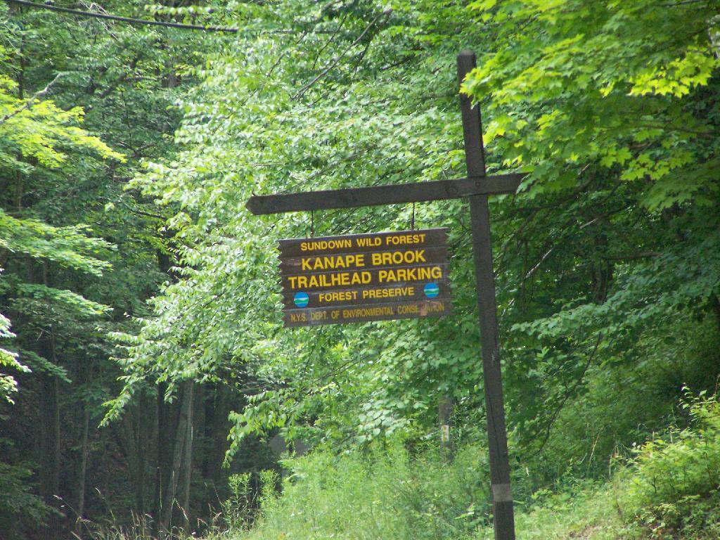
Trailhead Parking Lot Sign

TrailRoadNameNotesStreetCityStZIPLatitudeLongitude
Ashokan High PointWatson Hollow RoadKanape Valley Parking Lot 826 Watson Hollow RdWest ShokanNY1249441.9357923141228-74.3281141901214
Beaverkill RoadBeaverkill RoadBeaverkill Road Parking Lot 2795 Beaverkill RdLivingston ManorNY1275842.0117166110155-74.6223767934834
Beaverkill RoadTurnwood RoadBeaverkill Road Parking Lot 2952 Beaverkill RdLivingston ManorNY1275842.0233290355646-74.5995306115641
Becker Hollow TrailLane RoadBecker Hollow Parking Lot6 Vehicle Capacity3940 Route 214Elka ParkNY1242742.1816084527769-74.1969812784753
Bengle Hill TrailPeekamoose RoadEastern Upper Field Parking Lot 359 Peekamoose RdGrahamsvilleNY1274041.9166423616552-74.4377863112221
Bengle Hill TrailPeekamoose RoadLower Field Parking Lot 194 Peekamoose RdGrahamsvilleNY1274041.9101942400042-74.452852499381
Bengle Hill TrailPeekamoose RoadMiddle Field Parking Lot 304 Peekamoose RdGrahamsvilleNY1274041.9158997405029-74.443422031256
Bengle Hill TrailPeekamoose RoadNorth Middle Field Parking Lot 304 Peekamoose RdGrahamsvilleNY1274041.9164180048779-74.4416441135141
Bengle Hill TrailPeekamoose RoadTrailer Feild Parking Lot 359 Peekamoose RdGrahamsvilleNY1274041.9162603251141-74.4346555497984
Bengle Hill TrailPeekamoose RoadWestern Upper Field 359 Peekamoose RdGrahamsvilleNY1274041.9169982073948-74.4396463051141
Big Pond – Alder LakeBarkaboom RoadBarkaboom Road Parking LotLocated On Barkaboom Road, 6 Cars288 Barkaboom RdAndesNY1373142.0426860004001-74.7267519998891
Big Pond – Alder LakeCross Mountain RoadAlder Lake Parking Lot 2 Cross Mountain RdLivingston ManorNY1275842.0497953211373-74.6827571604492
Black Dome TrailBig Hollow RoadBig Hollow Road Parking Lot7 Vehicle Capacity947 Route 56MaplecrestNY1245442.2889033425096-74.1151262941519
Campbell Mountain TrailCat Hollow RoadRoute 206 Parking Lot5 Vehicle Capacity1611 County Road 7RoscoeNY1277642.051659649187-74.9147231839428
Cic – Esopus TrailState Route 28Parking Area For Esopus Creek Fishing AccessParking Area For Esopus Creek Fishing Access – Cic5067 Route 28Mount TremperNY1245742.0254799892217-74.2717292519349
Cic Hill TrailWittenberg RoadWittenberg Road Parking Lot 1298 Wittenberg RdMount TremperNY1245742.0279684988885-74.2620571929729
Colgate Lake Trail To Dutcher NotchColgate RoadColgate Lake Lower Parking Lot50 Vehicle Capacity525 Colgate RdEast JewettNY1242442.2384696568264-74.1233979344461
Colgate Lake Trail To Dutcher NotchColgate RoadColgate Lake Parking Lot2 Vehicle Capacity524 Colgate RdEast JewettNY1242442.2385040003097-74.1206960003026
Colgate Lake Trail To Dutcher NotchColgate RoadColgate Lake Trail Parking Lot8 Vehicle Capacity653 Colgate RdEast JewettNY1242442.2384599994304-74.1163269993959
Condon Hollow Rd.Condon Hollow RoadCondon Hollow Road Parking Lot3 Vehicle Capacity139 Condon Hollow RdWest KillNY1249242.2161010059593-74.4163349850283
Condon Hollow Rd.Elk Creek RoadElk Creek Road Parking Lot5 Vehicle Capacity734 Elk Creek RdFleischmannsNY1243042.1996047835286-74.4451315908425
Condon Hollow Rd.South Beech Ridge RoadBeech Road Parking Lot4 Vehicle Capacity291 S Beech Ridge RdWest KillNY1249242.2139020709257-74.4012095700882
Condon Hollow Rd.State Highway 42Rte 42 Parking Lot3 Vehicle Capacity1088 Route 42ShandakenNY1248042.1851525975488-74.4149115068685
Denman Mountain Snowmobile TrailGlade Hill RoadDenman Parking Lot 327 Glade Hill RdGrahamsvilleNY1274041.8853341886314-74.5320280123605
Denman Mountain Snowmobile TrailMoore Hill RoadHogs Roack Plot Parking Lot 578 Alpha RdGrahamsvilleNY1274041.9003387815796-74.5274487605523
Devil’s PathBroadstreet Hollow RoadBroadstreer Hollow Parking Lot2 Vehicle Capacity619 Broadstreet Hollow RdShandakenNY1248042.1394450770105-74.3308357356817
Devil’s PathSpruceton RoadSpruceton Road Parking Lot5 Vehicle Capacity1518 Spruceton RdWest KillNY1249242.1920191641918-74.3238474073796
Devil’s PathPrediger RoadPrediger Road 75 Prediger RdElka ParkNY1242742.1338909995054-74.1042720006852
Diamond Notch TrailDiamond Notch RoadSouth Diamond Notch Parking Lot2 Vehicle Capacity508 Diamond Notch RdWest KillNY1249242.147861770123-74.2646596008456
Diamond Notch TrailSpruceton RoadDiamond Notch Parking Lot8 Vehicle Capacity2778 Spruceton RdWest KillNY1249242.1823740001994-74.2695430002389
Dry Brook Ridge TrailMill Brook RoadDry Brook Ridge Parking Lot 12 Balsam Mountain Camp RdMargaretvilleNY1245542.0715022570921-74.5738756337513
Dry Brook Ridge TrailSouth Side SpurNorth End Of Dry Brook Ridge Parking Lot 301 Southside SpurMargaretvilleNY1245542.1446292458628-74.649333317932
Elm Ridge TrailPeck RoadPeck Road Parking Lot10 Vehicle Capacity189 Peck RdMaplecrestNY1245442.2965789997488-74.1693680002929
Fluggertown Road Long Pond TrailFluggertown RoadFlugertown Road Parking Lot 191 Flugertown RdLivingston ManorNY1275841.9347657909639-74.649696950272
Flynn TrailMongaup RoadMongaup Road Parking Lot 1 Beech Mountain RdLivingston ManorNY1275841.9467974587868-74.7052771774711
Giant Ledge-Panther Mountian-Fox Hollow TrailFox Hollow RoadFox Hollow Road Parking Lot 67 Mountain DrShandakenNY1248042.1008382907335-74.3904559601097
Giant Ledge-Panther Mountian-Fox Hollow TrailPeck Hollow RoadPeck Hollow Road Parking Lot 254 Peck Hollow RdShandakenNY1248042.1357649784827-74.3712920364471
Giant Ledge-Panther Mountian-Fox Hollow TrailPeck Hollow RoadEsopus Creek Fishing Access (Upper)Gravel7019 Route 28PheoniciaNY1246442.1065553340012-74.3519924442835
Giggle Hollow TrailNY 23 – BelleayrBelleayre Day Use Parking Lot 33 Friendship Manor RdPine HillNY1246542.1256810090987-74.4731178408634
Harding Road Spur TrailWhites RoadWhites Road Parking Lot4 Vehicle Capacity274 White RdPalenvilleNY1246342.1823951680298-74.0261906353256
Harding Road TrailHarding RoadHarding Road Parking Lot5 Vehicle Capacity3525 Route 23APalenvilleNY1246342.1762358120255-74.0304949714876
Huckleberry North TrailHill RoadHill Road Parking Lot4 Vehicle Capacity1209 Hill RdMargaretvilleNY1245542.1166129796449-74.6486105632054
Huckleberry North TrailHuckleberry Brook Spur RoadHuckleberry Brook Road Parking Lot6 Vehicle Capacity1613 Huckleberry Brook RdMargaretvilleNY1245542.1130238724914-74.6515523618233
Huckleberry South TrailHuckleberry Brook Spur RoadHuckleberry Road Parking Lot5 Vehicle Capacity1073 Huckleberry Brook RdMargaretvilleNY1245542.1152546105706-74.6636037740616
Huckleberry South TrailHull RoadPloutz Road4 Vehicle Capacity1634 Ploutz RdMargaretvilleNY1245542.0938719675255-74.6204457323272
Huggins Lake TrailBerry Brook RoadHuggins Lake Road Parking Lot4 Vehicle Capacity2414 Holiday And Berry Brook RdRoscoeNY1277642.0157959909969-74.8436914198853
Jockey Hill Bicycle TrailWood RoadWood Road Parking Lot 334 Woods RdKingstonNY1240141.9777439980953-74.0501113306995
Kaaterskill Falls TrailState Highway 23aMolly Smith Parking LotDot Facility, 20 Vehicles4729 Route 23AElka ParkNY1242742.1898508772368-74.074111945438
Kaaterskill Rail TrailLaurel House RdLaurel House Rd 103 Laurel House RdTannersvilleNY1248542.1956250050266-74.063093393786
Kelly Hollow Long Loop TrailMill Brook RoadEast Kelly Hollow Parking Lot 5163 Mill Brook RdMargaretvilleNY1245542.078800277463-74.6497556922038
Kelly Hollow Long Loop TrailMill Brook RoadWest Kelly Hollow Parking Lot 5163 Mill Brook RdMargaretvilleNY1245542.0795848697519-74.6545040693769
Long PathSteenburg RoadSteenburgh Road 2425 Platte Clove RdElka ParkNY1242742.1337889994516-74.0819709994867
Long PathRoute 23Route 23 Parking Lot20 Vehicle Capacity3 Cross RdWindhamNY1249642.312706999584-74.1904309994766
Long Pond South LoopWillowemock RoadWild Meadow Road Parking Lot 136 Round Pond RdClaryvilleNY1272541.9435338737706-74.5864488816452
Lost Clove TrailLost Clove RoadLost Clove Parking Lot 343 Lost Clove RdBig IndianNY1241042.1054379266455-74.4700849794812
Mary Smith TrailHolliday Brook RoadHoliday And Berry Brook Road Parking Lot5 Vehicle Capacity3851 Holiday And Berry Brook RdRoscoeNY1277642.0386999995498-74.8473909994493
Mckinley Hollow TrailMc Kinley Hollow RoadMckinly Hollow Parking Lot 200 McKinley Hollow RdBig IndianNY1241042.0704132895809-74.4740296153462
Mckinley Hollow TrailRider Hollow RoadRider Hollow Parking Lot 12 Warren Todd Subdivision DrArkvilleNY1240642.1018368545182-74.5170339246663
Mckinley Hollow TrailBurnham Hollow RoadBurnham Hollow Parking Lot 17 Sagmore TrlBig IndianNY1241042.05564157218-74.4669789486585
Middle Mountain TrailMary Smith Hill RoadMary Smith Hill Road Parking Lot3 Vehicle Capacity865 Mary Smith Hill RdAndesNY1373142.0401290003224-74.8089319993063
Mink Hollow TrailMink Hollow RoadLake Hill 599 Mink Hollow RdBearsvilleNY1244842.1051314008054-74.1735651990356
Mount Pleasant-Romer MountainState Highway 28Sawmill Lot50×50 Parking Area – Trailless6331 Route 28PhoeniciaNY1246442.1008585056075-74.3445327399439
Mud Pond TrailCounty Road 179aOld Rte 17 Fishing Access6 Vehicle Capacity6175 State Route 17 WRoscoeNY1277641.9497668355721-74.9281906252666
Mud Pond TrailHorton Brook RoadLittle Fuller Brook Parking Lot6 Vehicle Capacity845 Horton Brook RdRoscoeNY1277642.0159481159029-74.9790550095988
Onteora Lake Parking AccessState Highway 28Onteora Lake Trailhead Upper Lot 881 Route 28KingstonNY1240141.9807660434687-74.0853059041223
Onteora Lake Yellow TralNY 23Onteora Lake Parking 960 Route 28KingstonNY1240141.9840941553893-74.0827910535657
Overlook Spur Trail ExtensionMacdaniiel RoadMeads Meadow Parking Area 452 MacDaniel RdBearsvilleNY1240942.0756312690235-74.1276188121255
Overlook TrailMeads Mountain RoadOverlook Mountain Trailhead 334 Meads Mountain RdWoodstockNY1249842.0710794980857-74.1224765106456
Peekamoose-Table TrailPeekamoose RoadPeekamoose Road Parking Lot 415 Peekamoose RdGrahamsvilleNY1274041.9233895882109-74.4128616227944
Peekamoose-Table TrailPeekamoose RoadPeekamose Mountian Trail Head Parking Lot 415 Peekamoose RdGrahamsvilleNY1274041.9149365156904-74.4289858455429
Pelnor Hollow TrailBeaver Kill RoadWaneta Lake Parking Lot 732 Beaverkill RdLivingston ManorNY1275841.9676202925977-74.8292314401778
Phoenicia East Branch TrailDenning RoadDenning Road Parking Lot 3381 Denning RdClaryvilleNY1272541.9690314347788-74.4486958819482
Phoenicia East Branch TrailOliverea-Slide Mountain RoadOliverea Road North Parking Lot 1453 Oliverea RdBig IndianNY1241042.0265659167754-74.4038665935078
Phoenicia East Branch TrailOliverea-Slide Mountain RoadOliverea Road South Parking Lot 19 Shandaken Rod Gun ClbBig IndianNY1241042.0078280894865-74.4268762683237
Phoenicia TrailPlank RoadTremper Mountain Parking AreaGravel Lot5636 Route 28PhoeniciaNY1246442.0705625579484-74.3024012416267
Pine Hill West Branch TrailWest Branch RoadBiscuit Brook Parking Lot 1886 Frost Valley RdClaryvilleNY1272541.990833872737-74.4845571593918
PowerlineBeech Ridge Road 1Vinegar Hill Parking Area 1060 N Beech Ridge RdPrattsvilleNY1246842.2449000123037-74.4075985539776
Red Hill Fire Tower TrailRed Hill RoadRed Hill Fire Tower Parking Lot 129 Coons RdClaryvilleNY1272541.9302938486155-74.5073498606472
Roaring Kill TrailDale LaneRoaring Kill6 Vehicle Capacity155 Roaring Kill RdElka ParkNY1242742.1511360000949-74.1310779997324
Rochester HollowShaft RoadShaft 6 Parking20 Vehicle Capacity73 Shaft RdShandakenNY1248042.166173156258-74.4083342114093
Rochester HollowSpisak WayRochester Hollow Parking Lot 51 Matyas RdBig IndianNY1241042.1179698674129-74.4517651458059
Seager Big Indian TrailDry Brook RoadSeager Parking Lot 5672 Dry Brook RdArkvilleNY1240642.0578836653667-74.5396998623234
Spencer RoadTrails End RoadTrails End Parking Lot 197 Trails End RdKerhonksonNY1244641.8835868385135-74.3594081701432
Spruceton TrailSpruceton RoadSpruceton Trail Parking Lot20 Vehicle Capacity2628 Spruceton RdWest KillNY1249242.1846329998217-74.2719879999707
Touch-Me-Not-TrailBarkaboom RoadBig Pond Parking LotLocated Off Barkaboom Road, 6 Cars366 Barkaboom RdAndesNY1373142.0433679998314-74.7277000006876
Touch-Me-Not-TrailBeech Hill RoadBeech Hill Road Parking Lot3 Vehicle Capacity2054 Beech Hill RdAndesNY1373142.0506230001697-74.7789470006467
Touch-Me-Not-TrailDeerlick Brook RoadDeerlick Road Parking Lot3 Vehicle Capacity1553 Deerlick Brook RdAndesNY1373142.0814567992576-74.7365160981546
Touch-Me-Not-TrailBarkaboom RoadForest Preserve Access ParkingEast Of Barkaboom Road 3 Cars1954 Barkaboom RdAndesNY1373142.0655363440977-74.7284401046935
Trout Pond Access RouteRussell Brook RoadRussell Brook Road Parking Lot10 Vehicle Capacity4348 Russell Brook RdRoscoeNY1277641.9943949997582-74.941432999876
Trout Pond TrailCampbell Brook RoadCampbell Brook Road Parking Lot 4747 Campbell Brook RdDownsvilleNY1375542.0306374772623-74.9384473452279
Trout Pond TrailCampbell Mountain RoadCampbell Mountain Road Parking Lot5 Vehicle Capacity3693 Campbell Mountain RdDownsvilleNY1375542.0433291750688-74.9358959381363
Vernooy Kill Falls Snowmobile TrailDymond RoadDymond Road Parking Lot 498 Yeagerville RdNapanochNY1245841.8792625226568-74.4012606035291
Vernooy Kill Falls Snowmobile TrailUpper Cherrytown RoadUpper Cherry Town Road Trail Head Parking Lot 559 Upper Cherrytown RdKerhonksonNY1244641.8643822024537-74.3454535201223
Willow TrailAbbey RoadMount Toblas Parking Lot 439 Abbey RdMount TremperNY1245742.0537752508176-74.2306894602594
Willow TrailJessup RoadWillow Trailhead Parking6 Vehicle Capacity218 Jessop RdWillowNY1249542.078213053797-74.2442314353898

Site Map

🌲🌲 Our Public Lands 🌳🌲

Interactive maps with backcountry and roadside camping: New York, Pennsylvania, West Virginia & Vermont.
List of NYS DEC Lean-Tos with map coordinates. List of NYS DEC Firetowers with map coordinates and more information.
Google Spreadsheet with Roadside, Primitive and Pay Campsites

Explore the Finger Lakes Trail, Long Path, Northville-Placid Trail and Long Trail/Appalachian in Vermont.
Catskill Park Mountain Peaks, Hudson Valley & Long Island Peaks, Peaks Over 3000 ft Elevation, Highest Peaks in Adirondacks, Interactive Map of All Named Summits in NYS, Blaze Colors in Catskill Park, Trailhead Parking Coordinates and Addresses in the Catskills.

Browse USGS Topo Quads as PDF 🆕 by State Lands or County. You can Bulk Download New & Old USGS Topograpic Maps.

Links to various NY State Land Websites 🆕. Get latest GIS Data from state Web Services.

⛺🌲 Camp 🌲🏕

Moose River PlainsCampsite Listing, Maps and photos of state’s largest free camping area.
Piseco-Powley RoadCampsite Listing, Maps and photos of 15 mile dirt road with camping.
Catskill Park Primitive CampsitesAn overview of free camping locations in Catskill Park.
Burnt-Rossman Forest, Cattaraugus County, East Branch Sacandaga River, Finger Lakes National Forest, Madison County, Pennsylvania, Vermont and West Virigina.

Campsite Coordinates for Bog River Flow / Lows Lake, Hudson River SMA (Buttermilk Falls), Lake Lila, Oswegathie River, Nine-Corner Lake, Pharaoh Lake Wilderness, Saranac River Campsites, Stillwater Lake, Schoharie County, and Sugar Hill State Forest.

Overview of Camping Areas in the Catskills, Green Mountains, Southern Adirondacks, Central Adirondacks, Northern Adirondacks, Allegheny National Forest and Penna. DCNR Motorized Campsites and the Monongahela National Forest West Virginia.

Free Campsite Overview Maps: Adirondack – North Country, Catskills, Central NY, Finger Lakes, Western NY. Interactive Map.

Places I camped in 2023, 2022, 2021 and 2020.

🏞 🛹 Bicycle Trails and “Blackie” My Mountain Bike 🚲 🚶

Finally bought a mountain bike, after chewing over a mountain vs commuter bike. Really enjoying riding my bike to work and when it rains there is always a bike rack to safely take it back home. One way to get to adventures at Thacher Park is the Nature Bus.

Empire Trail – KMZ and Interactive Map. Parking along it.

More Trailways with KMZ files including the Albany County Rail Trail, Black Diamond Trail, Catharine Valley Trail, Catskill Scenic Trail, Fonda, Johnstown & Gloversville Rail Trail, Genesee Valley Trail, Link Trail.

🦌🌲 Hunt 🦃🐿

Wildlife Management Units (Deer)KMZ Map shows the WMU boundaries.

Summer 2019 Aerial Photographs of WMUs

KMZ Maps of Deer Harvest Density by Town: 2019, 2018, 2017, 2016. By WMU 2017, 2016, 2015.

KMZ Maps of Buck Harvest Density by Town: 2019, 2018, 2017, 2016. By WMU 2017, 2016

2016 -2019 Deer and Buck Harvest by TownKMZ Spreadsheet with FIPS codes for making your own calculations.

🎣🐡 Fish 🐟🐠

Parking and Access to Trout StreamsAn interactive, downloadable KMZ Map.
Lakes with DEC Contour MapsA KMZ Map links to Contour Maps for Fishing.

🌨🏔 Sled & Wheel 🚙❄

State Truck Trails Over A Half MileDirt roads to explore in the backcountry.
NYS Statewide Snowmobile Trail SystemState trails on public and private lands.

📉📊 Learn 💵📈

Interactive Maps of NY CensusExplore and download KML files.
Charts and Interactive DiagramsFrom population to pollution control.
Andy Arthur GitHubGit my R and Python scripts used to make maps and diagrams.
Use ArcPullR to Get Geospatial DataSuper easy way to connect to get GIS data in R from government servers.
GDAL Opens E00 FilesMost open source programs nowadays can open common geospatial formats.
NY Building FootprintsWhere to find on the internet for making maps.
WMS and ArcMap ServicesDownloadable CSV file listing services used on the blog.
2022 US Census Population EstimatesRed states, south continue to gain population.
2020 Cartogram of State Population

💳 🏛 Property Taxes 🏠💸

Properties in Albany Pine Bush Study Area, Excel Files: Various Tax Rolls, Find coordinates and political districts, Look Up State Tax Records and a Script for Processing RPTL 1520 PDFs. Match NY SWIS Codes to FIPS Codes and GEOID

🚗🚗 Big Red 🚗🚗

Big RedPhotos and Videos of my lifted truck with its camper shell. Big Red’s Dual Battery Setup for Camp Power, Video Tour and Diagram. Big Red is getting old. What is next? I’ve thought about going carless for a while to save money and reduce pollution. Or maybe going bigger? Or smaller? Five dollar gas sucks.

🔥🌲 Off-Grid Living 🏠🤠

I am seriously thinking about building an off-grid house. I have a first draft. I need to learn CAD! I have a road map towards buying land and building. I concede might have to live with long commute and give up traveling and camping. I need to be strong.

Why off grid? Well, I’m not into contemporary society. I want to own land, but not be called a landowner, and a cabin, not hooked to electrical grid, farm, raise pigs for food and burn my own trash. I’m saving for a better tomorrow, hoping to make the leap to another freer state. Having acreage is important. Cornfields aren’t bad neighbors. Maybe though my vision has grown smaller and more local. More on off-grid living.

I am 16 years into my career and have made some significant progress in my life. I love my job. But I do wonder on all the things I’m missing out but saving sure makes me high. Maybe it will be different when I own my own land — the end of goal of all this saving.

2020 into 2021 during the pandemic was a year of remote work. It was a struggle not having internet at home, worked a lot out of my truck. But I worked remotely from Horseshoe Lake which was super cool.

Generally I like the idea of owning land in a red state, particularly Idaho, Iowa, Pennsylvania, West Virginia, Wisconsin — and Midwest more generally. But I may settle for New York – it’s all about the f-ing money!

💻👨‍💻 Open Source 🗺️📍

I use open source software and public sources of data for the blog. Quantum GIS (QGIS), GDAL/ogr2ogr, PyQGIS, GeoPANDAS, R Studio and Leaflet for map making, Arduino and ESP32 microprocessors, Ubuntu Linux and XFCE Window Manager. I’ve recently gotten interested in machine learning.

I avoid using commercial software like Microsoft Windows and do not have home internet or television. If you don’t use commercial software and use your brain, fears of computer viruses are overblown. I deleted most of my social media accounts.

Creating Digital Surface Models using LiDAR Point Clouds.

📊🗺 R Statistical Programming 📜👨‍🏫

The R programming language and RStudio are powerful tools for statistical analysis, making maps and charts. Many of the blog posts and analysis I do are in R, ggplot not only makes great charts but also maps using tidycensus. Generally, R is better then Python for geospatial work.

Use IDW Interpolation to fill in missing Census data, Zonal Histograms for land cover, load WMS Aerial Photography in R, find mountain peaks, save Census shapefiles using tigris quickly, pull NY Election Night Results using Selenium. Fast reverse Geocoding in PostGIS. Working with PDFs in R. Fix a common error starting rselenium/wdman. Make data-filled calendars. R is wonderful and weird, learn it!

🐼🔢 Python and Pandas 💻🐍

Querying state property database, political enrollments, PL 94-171 Census files, calculating population statistics, what address is a district in, converting old districts to new districts, Shapefiles missing Projection information in QGIS.

Learn to code for free modern HTML, Javascript, Python and SQL at freeCodeCamp and web development at the Odin Project.

🐴 🐘 Politics 🦁 🐍

Crunched Election Results with Turnout for Albany County: November 2023, 2022, 2021, 2020, 2019 and Primaries June 2019, Pres/June 2020, June 2021, June 2022, Aug 2022, June 2023.

Albany County Races converted to the new 2023 EDs using Super EDs and Code: 2022, 2021, 2020, 2019 and Primaries June 2019, Pres/June 2020, June 2021, June 2022, Aug 2022.

Above Election Results as zipped Excel files.

Albany County Legislature Districts 2024 Maps

Maps Comparing 2017 and 2023 Albany County Election Districts and a Crosswalk Table Showing the Proposition of Voting Age Population in New and Old EDs

Maps of 2022 NYC Assembly Races, NYS Assembly Races, NY Senate Races, Governor’s Race in Erie County and Statewide. Partisan shift in governor race between 2010 and 2018.

A comparison of Democratic Performance 2022 Assembly Districts to those proposed in 2023 by the IRC. Here is latest 4/20/23 IRC Maps, showing ADP and how they change from existing Assembly districts. Most towns upstate, outside of cities, are quite red. Using LATFOR data with R to calculate Average Democratic Performance.

You can scrape employee salary data from SeeThroughNY using R. Other useful investigative resources.

I often think politics is for losers. I’m into the politics of statistical analysis and reading history books.

I believe strongly in the first amendment, second amendment, oppose gun restrictions and I support de-funding the police in favor of lower-cost technology and civilian employees. Maybe use red flag laws for voting to stop dangerous voters? And the media should stop promoting mass-shootings, even if it’s super profitable for all involved. They should tax the media when it promotes violence. I think some people are much too paranoid in politics. How elections are rigged under law to benefit incumbents. But vote, it’s the best option and inexpensive.

Yeah for the third parties! I voted for Larry Sharpe for Governor and Jo Jergenson for President but my views are complicated and often vote for Democrats, after voting Jill Stein Green Party in 2016.

Generally, I think Biden has been a good change over DJT and glad the Trump era is over and are glad prosecutors and grand jurors are holding him responsible by indicting him for many serious felonies. I don’t think Trump can win in 2024, as nothing has changed politically from 2020.

I think rural people should be left alone and not worship government workers or have parades for them. I am no fan of Donald Trump, his speeches are bad, I don’t like Trump’s embrace of radical environmentalists, but do admire the homemade roadside monuments to DJT.

I don’t toke. But whatever. There are too many transit authorities.

🌲🌳The Earth 🌎 🐸

Why I oppose wilderness areas and parks. It’s trendy to be green these days, but is eco-marketing good for the planet? I visited the Mount Storm Coal Plant and Corridor H.

I worry about a lot about overly-aggressive Climate Change Action, and Undermining Environment Laws for Climate Action. I think we should all admit we are Addicted to Fossil Fuels. These days, urban recycling has become a joke, when it’s still an option at all. It’s better to just buy less shit and avoid the alure of Costcos. I really don’t like how aging radicals have become industrial solar salespeople.

Big bucks are coming to state-designated disadvantaged communities under the CLCP. Which counties and political districts are in line for the the most pork? Interactive map.

I’m a big of farmers who are essentially Living Off the Earth and think Rednecks are Noble Savages. Dairy Farming are key to our rural landscape. I’d trust a farmer or a hunter in a pile of guts he’s butchered over any ivory-tower scientist.

🌎🔆 Industrial Solar 🌞 🏭

Hundreds of multi-acre industrial solar farms are being built in our state. How bad is solar for the environment? We should ask tough questions. Interactive of recently built solar farms, proposed facilities. List of proposed industrial solar facilities. See how the Greenville Solar Farm changed the landscape.

💳 💸Saving Money 💰 💷

I am not a fan of ESG Investing as it’s not well diversified. I prefer index-funds and other tax-advantaged ways of saving. Why I am concerned about saving enough for retirement, even though I’m in my late 30s. We as a nation should save more, consume less. I like the idea of carbon tax to replace capital gains taxes to discourage consumption.

🥦 🍎Mission Fifty & Being Healthier 🏠🧠

I am now officially in my 40s! I am building to a better life in my 50s, which means getting up early, walking a lot, saying no to cake and yes to more fruit. In many ways, the forties are an awesome time to be alive.

And eating healthy for less without losing sleep over arsenic. And I don’t think we should subsidize unhealthy habits. How I got started in eating healther. Meals are too focused on meat and carbs due to how we describe them, maybe I eat too many bananas in the office, what to eat while camping, worry more about salt then GMOs, eat more beans. Do spend extra for farmers market peaches, especially doughnut peaches and plums. Consider ethnic supermarkets. Thinking about how to make a healthier macaroni and cheese, spinach-mackeral-pasta salad, quick-cook biscuits and whole-wheat bread. That said, too many recipes are junk food crap. Okay in moderation is not okay. The fact that I’m thinner is not a sign I’m dying.

A few years back I decided to explore my mental illness with therapy, thinking about why I have so much anxiety and how many of my values are rational or just thinking too much rednecks’ burn barrels and how much of a throwaway society we live in. Do I want to change?

I’ve learned to care less about the world, and focus more on myself. Maybe I am happier as I am now, saving and investing a lot towards owning my own land, where I don’t have to deal with all the bullshit of modern life.

Mission Fifty: Getting to the point where I own my own land. 🚜
Healthy Eating 🍎 / Growing My Wealth 💰
Healthy Thoughts 💭 / Enjoying Life 😃

Questions, comments? Feel free to email me at andy@andyarthur.org.

You do your thing, I’ll do mine.

I use GNU open source software.
Plus I like buck goats,
because they’re real macho men
spraying their beards with goat urine.

March is upon us. Get out, enjoy it, be safe with fire and burning shit, and remember soon enough black flies are waiting.” – Andy Arthur

Return to the Top

Laugh a bit and learn how your data is used on this blog: Privacy Policy

This blog is © Copyright 1997-2023 Andy Arthur.org, please share using the Creative Commons Attribution 3.0 License.

Categories:

Links to NYS DEC Webpages on State Land and Topographic Maps 🗺 🌳

Here is an updated list of state land websites for March 2023. The topographic map links will bring you to the latest USGS Topographic Maps for the area, or you can use the listing to bulk download the maps or get the quads you need from USGS Store or your local map seller.

Facility Acres UMP USGS Topographic Map Quads (50-60 MB PDF)
Albany
Albany Pine Bush Preserve 1,918 Pine Bush Albany, Schenectady, Voorheesville
Black Creek Marsh WMA 580 Voorheesville
Catskill Creek Fishing Access 1 Durham
Coeymans Creek WMA 718 Delmar, Ravena
Cole Hill State Forest 858 Albany Westerlo
Five Rivers Environmental Education Center 445 Five Rivers Env Ed Center Clarksville
Louise E. Keir WMA 188 Louise E. Keir HMP Clarksville
Margaret Burke WMA 246 Margaret Burke HMP Altamont
Onesquethaw Creek Fishing Access 0 Delmar
Partridge Run State Forest 935 Albany Rensselaerville
Partridge Run WMA 8,231 Partridge Run HMP Rensselaerville, Westerlo
Rensselaerville State Forest 5,142 Albany Durham, Rensselaerville
Allegany
Allen Lake State Forest 4,849 Allegany Angelica, Fillmore
Alma Pond 130 Allentown, Wellsville South
Bald Mountain State Forest 763 Allegany West Almond
Bully Hill State Forest 7,048 Allegany Alfred, Hornell
Cold Creek State Forest 496 Allegany Pike
Coyle Hill State Forest 4,691 Allegany Angelica, Belmont
Crab Hollow State Forest 2,301 Allegany Black Creek, Rawson
English Hill State Forest 2,789 Allegany Birdsall, Fillmore
Gas Springs State Forest 4,551 Allegany Birdsall, Canaseraga
Genesee River Wildlife Management Area 318 Wellsville South
Genesee Valley WMA 717 Portageville
Gillies Hill State Forest 4,656 Allegany Birdsall, West Almond
Hanging Bog WMA 9,120 Hanging Bog HMP Black Creek, Rawson
Hanging Bog WMA – Showy Lady Slipper 2 Black Creek
Hiltonville State Forest 3,029 Allegany Alfred, Canaseraga, West Almond
Jersey Hill State Forest 1,092 Allegany West Almond
Karr Valley Creek State Forest 3,831 Allegany Alfred, West Almond
Keeney Swamp State Forest 2,411 Allegany Birdsall
Keeney Swamp WMA 1,232 Keeney Swamp HMP Birdsall, Canaseraga
Klipnocky State Forest 5,422 Allegany Alfred, Canaseraga
Lost Nation State Forest 5,400 Allegany Bliss, Freedom, Houghton, Pike
Palmer’s Pond State Forest 5,441 Allegany Alfred, West Almond
Phillips Creek State Forest 10,916 Allegany Alfred, Andover, Wellsville North, West Almond
Plumbottom State Forest 1,680 Allegany Wellsville North
Rush Creek State Forest 1,405 Allegany Black Creek
Slader Creek State Forest 1,225 Allegany Canaseraga
Swift Hill State Forest 1,571 Allegany Houghton
Turnpike State Forest 9,522 Allegany Alfred, West Almond
Vandermark State Forest 4,850 Allegany Andover, Wellsville North
Wag Trail 148 Allegany Wellsville South, Whitesville
Bronx
Bronx River Trail 1 Central Park, Flushing
Broome
Beaver Flow State Forest 2,053 Chenango Trail Belden, Brisben
Beaver Pond State Forest 2,372 Broome Afton, Gulf Summit, North Sanford
Cascade Valley State Forest 534 Broome Gulf Summit
Cat Hollow State Forest 760 Broome Deposit
Hawkins Pond State Forest 538 Broome Windsor
Kirkwood Sub-Office 10 Binghamton East
Marsh Pond State Forest 1,794 Broome Afton, Gulf Summit
Melondy Hill State Forest 1,983 Treaty Line North Sanford
Nanticoke Creek Fishing Access 1 Maine
Nanticoke Lake Multiple Use Area 339 Long Pond Lisle
Oquaga Creek Fishing Access 0 Deposit
Skyline Drive State Forest 1,066 Broome Binghamton East, Windsor
Susquehanna Waterway Access 1 Windsor
Tracy Creek State Forest 507 Broome Endicott
Triangle State Forest 1,988 Long Pond Smithville Flats, Whitney Point, Willet
West Branch Delaware River Waterway Access 3 Deposit
Whitaker Swamp State Forest 808 Broome Deposit
Cattaraugus
Bear Creek State Forest 562 Cattaraugus Franklinville
Birch Run Ponds Fwma 39 Knapp Creek
Boyce Hill State Forest 979 Cattaraugus Ashford
Bryant Hill State Forest 511 Cattaraugus Ashford
Bucktooth State Forest 2,281 Cattaraugus Little Valley
Bush Hill State Forest 11,295 Cattaraugus Delevan, Franklinville, Freedom, Rawson
Cattaraugus Creek Waterway Access 5 Collins Center
Cattaraugus State Forest 1,061 Cattaraugus Cattaraugus
Conewango Creek Waterway Access 267 New Albion
Conewango Swamp WMA 1,403 Kennedy, Randolph
Dobbins Memorial State Forest 2,206 Cattaraugus Cattaraugus, Ellicottville
East Otto State Forest 1,382 Niagara Frontier Collins Center
Elkdale State Forest 432 Cattaraugus Little Valley
Farmersville State Forest 1,148 Cattaraugus Freedom
Golden Hill State Forest 5,772 Cattaraugus Ashford, Franklinville, Humphrey
Harwood Lake Mua 602 Harwood Lake HMP Delevan, Freedom
Ischua Creek Fishing Access 1 Franklinville
Lime Lake Outlet Fishing Access 0 Delevan
Mansfield Creek Fishing Access 0 Cattaraugus
Mccarty Hill State Forest 6,399 Cattaraugus Ellicottville, Salamanca
Nine Mile Creek State Forest 6,681 Cattaraugus Humphrey, Knapp Creek
Pine Hill State Forest 1,142 Cattaraugus Steamburg
Poverty Hill WMA 1,106 Ellicottville
Raecher Hill State Forest 842 Cattaraugus Humphrey
Randolph Fish Hatchery 62 Randolph
Rock City State Forest 2,918 Cattaraugus Salamanca
South Valley State Forest 8,728 Cattaraugus Ivory, Steamburg
Windfall Creek State Forest 2,930 Cattaraugus Humphrey, Limestone, Salamanca
Zoar Valley Multiple Use Area 2,524 Zoar Valley Mua Collins Center, Gowanda
Zoar Valley Unique Area 2,992 Zoar Valley Mua Collins Center, Gowanda
Cayuga
Bear Swamp State Forest 5,642 Hewitt-Cayuga Highlands Sempronius, Spafford
Carpenter Falls Unique Area 37 Hewitt-Cayuga Highlands Spafford
Cross Lake Islands WMA 0 Jordan
Dutch Hollow Brook Parking Area 0 Owasco
Frozen Ocean State Forest 753 Hewitt-Cayuga Highlands Owasco
Northern Montezuma WMA 5,348 Montezuma, Victory
Owasco Flats WMA 52 Moravia
Owasco Lake Inlet Fishing Access 7 Moravia
Owasco Lake Water Access 9 Owasco
Seneca River Boat Launch 3 Weedsport
Summer Hill State Forest 8,842 Hewitt-Cayuga Highlands Moravia, Sempronius
Chautauqua
Alder Bottom WMA 820 North Clymer
Bear Lake Boat Launch 4 Hartfield
Boutwell Hill State Forest 2,965 Chautauqua County Hamlet
Brokenstraw State Forest 1,900 Chautauqua County North Clymer, Panama
Canadaway Creek Nature Sanctuary 33 Dunkirk
Canadaway Creek WMA 8,759 Canadaway Creek HMP Cassadaga, Dunkirk, Forestville, Hamlet
Chatauqua Creek Fishing Access 6 Westfield
Chautauqua Fish Hatchery 69 Chautauqua
Chautauqua Gorge State Forest 547 Chautauqua County Sherman
Chautauqua Lake Fish And Wildlife Management Area 134 Chautauqua, Ellery Center
Clay Pond WMA 215 Jamestown
Clear Creek Fishing Access 2 Hamlet
Dunkirk Office 6 Dunkirk
Findley Lake Waterway Access 0 Clymer
Harris Hill State Forest 3,504 Chautauqua County Gerry, Hamlet, Kennedy
Hartson Swamp WMA 199 Gerry, Jamestown
Hatch Creek State Forest 2,567 Chautauqua County Gerry, Hamlet
Hill Higher State Forest 1,160 Chautauqua County Panama
Jacquins Pond WMA 31 North Clymer
Kabob WMA 37 Kabob HMP Cassadaga
Mount Pleasant State Forest 1,539 Chautauqua County Sherman
North Harmony State Forest 5,150 Chautauqua County North Clymer, Panama
Panama State Forest 2,449 Chautauqua County North Clymer, Panama
Stockton State Forest 1,968 Chautauqua County Cassadaga, Hartfield
Watts WMA 1,395 Panama
Wellman Multiple Use Area 447 Chautauqua County Lakewood
Whalen Memorial State Forest 5,387 Chautauqua County Chautauqua, North Clymer, Panama, Sherman
Chemung
Big Flats WMA 241 Great Divide Seeley Creek
Catharine Creek Fishing Access 3 Montour Falls
Catlin State Forest 607 Great Divide Big Flats
Maple Hill State Forest 1,191 Great Divide Waverly, Wellsburg
Chenango
Ambler State Forest 642 Between Rivers Holmesville
Balsam Swamp State Forest 5,359 Five Streams East Pharsalia, Pitcher
Basswood State Forest 935 Between Rivers Oxford
Beaver Meadow State Forest 5,816 Northern Chenango Highlands Otselic
Berry Hill Radio Facility 1 East Pharsalia
Bobell State Forest 2,159 Chenango Trail Brisben
Bucks Brook State Forest 2,178 Northern Chenango Highlands South Otselic
Bumps Creek State Forest 527 Chenango Trail West Bainbridge
Coventry State Forest 2,337 Chenango Trail Brisben, West Bainbridge
Five Streams State Forest 9,946 Five Streams Pitcher, Smithville Flats
Genegantslet Creek Fishing Access 0 Smithville Flats
Genegantslet State Forest 6,405 Mcdonough Smithville Flats, Tyner
Hunts Pond State Forest 2,748 Between Rivers Holmesville, New Berlin South
Lincklaen State Forest 5,903 Northern Chenango Highlands Pitcher, South Otselic
Long Pond State Forest 3,185 Long Pond Smithville Flats
Ludlow Creek State Forest 3,197 Mcdonough Tyner
Lyon Brook State Forest 527 Between Rivers Oxford
Mcdonough State Forest 12,700 Mcdonough East Pharsalia, Tyner
Melondy Hill State Forest 6,052 Treaty Line Afton, North Sanford
Oak Ridge State Forest 1,130 Chenango Trail Sidney, West Bainbridge
Otselic State Forest 2,082 Northern Chenango Highlands Otselic, South Otselic
Perkins Pond State Forest 7,812 Pharsalia Woods East Pharsalia, Otselic, Pitcher, South Otselic
Pharsalia WMA 9,352 Pharsalia HMP East Pharsalia, Otselic
Pharsalia Woods State Forest 17,846 Pharsalia Woods East Pharsalia, Norwich, Pitcher
Pigeon Hill State Forest 2,209 Pharsalia Woods Earlville, East Pharsalia, Otselic
Pine Ridge State Forest 275 Between Rivers Sherburne
Pitcher Springs State Forest 1,836 Pharsalia Woods Pitcher
Red Brook State Forest 602 Five Streams Smithville Flats
Rogers Environmental Education Center 575 Earlville
Sherburne Sub-Office 12 Earlville
Skinner Hill State Forest 3,335 Between Rivers Holmesville, Sherburne
South Hill State Forest 2,647 Between Rivers Guilford, Sidney
South Otselic Fish Hatchery 142 South Otselic
Susquehanna River Boat Launch 6 Afton
Unadilla River Fishing Access 1 Holmesville
Whaupaunaucau State Forest 1,187 Between Rivers Holmesville
Wiley Brook State Forest 2,481 Between Rivers Oxford, West Bainbridge
Clinton
Ausable Marsh WMA 730 Keeseville
Ausable Point Campground 111 Ausable Point Camp Keeseville
Burnt Hill State Forest 3,157 Taylor Pond Dannemora, Peasleeville
Cadyville State Forest 371 Northern Clinton Dannemora
Chazy Highlands State Forest 11,081 Chazy Highlands Dannemora, Ellenburg Center, Ellenburg Mountain, Moffitsville
Chazy Highlands Wild Forest 51,403 Chazy Highlands Alder Brook, Brainardsville, Ellenburg Center, Ellenburg Mountain, Lyon Mountain, Moffitsville, Redford
Chazy Highlands WMA 1,005 Lyon Mountain
Clinton FP Detached Parcel 679 Churubusco, Ellenburg Depot, Mooers
Clinton Mooers FP Detached Parcel 664 Altona, Ellenburg Depot
Dunkin’s Reserve State Forest 4,573 Chazy Highlands Dannemora, Jericho, West Chazy
Flat Rock State Forest 3,669 Northern Clinton Altona, Jericho, Mooers, West Chazy
Garden Island 1 Lake Champlain Islands Keeseville
Great Chazy River Fishing Access 60 Altona
Great Chazy River Special Use 0 Champlain
Imperial Mills Dam 7 Plattsburgh
Kings Bay WMA 671 Champlain, Rouses Point
Lake Alice WMA 5,924 Beekmantown, Champlain, Mooers, West Chazy
Lewis Preserve WMA 1,325 Jericho
Macomb State Forest 2,800 Northern Clinton Dannemora, Morrisonville, Peasleeville, Peru
Montys Bay WMA 318 Beekmantown
Moon Pond State Forest 787 Chazy Highlands Ellenburg Mountain
Peru Dock Boat Launch 10 Lake Champlain Islands Keeseville
Plattsburg Boat Launch 0 Plattsburgh
Rouses Point 50 Rouses Point
Saranac River Access 0 Morrisonville
Spoon Island Primitive Area 2 Lake Champlain Islands Plattsburgh
Spring Brook State Forest 2,045 Chazy Highlands Altona, Ellenburg Depot, Ellenburg Mountain, Jericho
Taylor Pond Campground 147 Taylor Pond Camp Wilmington
Taylor Pond Wild Forest 5,640 Taylor Pond Keeseville, Peasleeville, Redford
Terry Mountain State Forest 4,814 Taylor Pond Peasleeville
The Gulf Unique Area 606 Northern Clinton Ellenburg Depot
Unclassified 3 Redford
Upper Chateaugay Lake Boat Launch 2 Chazy Highlands Ellenburg Center
Valcour Island Primitive Area 1,891 Lake Champlain Islands Keeseville, Plattsburgh
Wilmington Wild Forest 2,113 Wilmington Au Sable Forks, Wilmington
Columbia
Beebe Hill Multiple Use Area 2,913 Taconic Highlands Chatham, State Line
Beebe Hill State Forest 548 Taconic Highlands State Line
Charles Flood WMA At The Empire Brickyard 590 Hudson North
Doodletown Wildlife Management Area 2,155 Ancram, Copake
Hand Hollow State Forest 1,139 Taconic Highlands Canaan
Harvey Mountain State Forest 2,008 Taconic Highlands State Line
Livingston State Forest 319 Taconic Highlands Hudson South
New Forge State Forest 677 Taconic Highlands Ancram
Nutten Hook State Tidal Wetland 1,174 Hudson North, Ravena
Rogers Island WMA 322 Hudson Valley Hudson South
Stockport Flats Estuarine Sanctuary 478 Hudson North
Stockport WMA 354 Stockport HMP Hudson North
Cortland
Baker School House State Forest 2,527 Taylor Valley Cincinnatus, Mcgraw
Casterline Pond Waterway Access 15 Homer
Cortland Sub-Office 25 Cortland
Cuyler Hill State Forest 5,635 Cuyler Hill Cuyler
Dog Hollow State Forest 729 Cuyler Hill Cuyler
Donahue Woods State Forest 1,158 Taylor Valley Truxton
East Branch Tioughnioga River Fishing Access 1 Cuyler
Gee Brook State Forest 865 Taylor Valley Cincinnatus
Griggs Gulf State Forest 2,346 Rockefeller Harford
Grout Brook Fishing Access 20 Sempronius, Spafford
Hewitt State Forest 1,875 Hewitt-Cayuga Highlands Homer, Otisco Valley
Hoxie Gorge State Forest 3,067 Taylor Valley Marathon, Mcgraw
James Kennedy State Forest 11,071 Virgil Mountain Cortland, Harford, Marathon
Kettlebail State Forest 579 Hill And Hollow Tully
Maxon Creek State Forest 905 Cuyler Hill Cuyler
Morgan Hill State Forest 12,510 Hill And Hollow Cuyler, Deruyter, Truxton, Tully
Owasco Flats WMA 15 Moravia
Papish Pond Multiple Use Area 383 Taylor Valley Cincinnatus, Willet
Taylor Valley State Forest 18,523 Taylor Valley Cincinnatus, Cuyler, Mcgraw, Truxton
Tuller Hill State Forest 3,983 Virgil Mountain Cortland, Mcgraw
Tully Lake Fishing Access 1 Otisco Valley
Delaware
Andes FP Detached Parcel 98 Lewbeach
Arctic China State Forest 4,142 Treaty Line North Sanford, Trout Creek
Barbour Brook State Forest 759 Treaty Line Trout Creek
Beals Pond State Forest 1,113 Treaty Line North Sanford
Bear Spring Mountain Campground 12 Bear Spring Mountain Camp Corbett
Bear Spring Mountain WMA 14,280 Corbett, Walton East
Beaverkill Fishing Access 2 Roscoe
Colchester FP Detached Parcel 779 Corbett, Roscoe
Columbia Lake State Forest 701 Treaty Line Deposit
Davenport FP Detached Parcel 195 West Davenport
Delaware County Scenic Resource 218 East Branch Roscoe
Delaware FP Detached Parcel 67 Roscoe
Delaware Wild Forest 112,455 Delaware Arena, Corbett, Downsville, Lewbeach, Livingston Manor, Roscoe
Dry Brook Ridge Wild Forest 30,837 Dry Brook Ridge Arena, Fleischmanns, Lewbeach, Margaretville, Seager
East Branch Delaware River Waterway Access 12 Fishs Eddy
Hancock FP Detached Parcel 1,936 Fishs Eddy, Horton, Long Eddy
John Lennox State Demonstration Forest 175 Davenport
Kerryville State Forest 703 Treaty Line Cannonsville Reservoir
Little Pond Campground 874 Little Pond Camp Arena, Lewbeach
Lower West Branch Delaware River Fishing Access 4 Deposit
Michigan Hill State Forest 2,376 Treaty Line Cannonsville Reservoir, Deposit, North Sanford, Trout Creek
Middletown FP Detached Parcel 62 Margaretville
Murphy Hill State Forest 2,530 East Branch Andes, Downsville, Hamden, Lewbeach
Pine Hill State Forest 2,182 Treaty Line Sidney, Unadilla
Plattekill State Forest 1,788 East Branch Hobart
Relay State Forest 2,554 East Branch Hobart, Roxbury
South Hill State Forest 1,044 Cherry Valley Davenport, Schenevus
Stamford FP Detached Parcel 79 Stamford
Stamford Regional Sub-Office 12 Stamford
Steam Mill State Forest 11,176 Treaty Line North Sanford, Trout Creek
Tomannex State Forest 2,028 East Branch Corbett, Readburn
Tompkins FP Detached Parcel 719 Cannonsville Reservoir, Trout Creek
Town Brook Fishing Access 0 Roxbury
Walton FP Detached Parcel 110 Walton East
West Branch Delaware River 11 Deposit
Wolf Hollow WMA 52 East Branch Andes
Dutchess
Baxtertown Woods WMA 248 Wappingers Falls
Crum Elbow Creek Fishing Access 1 Hyde Park
Crum Elbow Creek Waterway Access 13 Hyde Park
Depot Hill Multiple Use Area 256 East Of Hudson Poughquag
Lafayetteville Multiple Use Area 718 East Of Hudson Pine Plains
Roeliff Jansenkill Multiple Use Area 119 East Of Hudson Ancram
Shekomeko Creek Parking Fishing Access 0 Pine Plains
Stissing Mountain Multiple Use Area 590 East Of Hudson Pine Plains
Stonykill Environmental Education Center 786 Wappingers Falls
Swamp River Fishing Access 0 Dover Plains
Swamp River Waterway Access 58 Dover Plains
Sylvan Lake Waterway Access 0 Poughquag
Taconic Hereford Multiple Use Area 2,751 East Of Hudson Pleasant Valley, Salt Point, Verbank
Tivoli Bays WMA 1,679 Saugerties
Wappinger Creek Fishing Access 2 Millbrook
Wassaic Creek Fishing Access 9 Amenia
Wassaic Multiple Use Area 513 East Of Hudson Amenia
West Mountain State Forest 3,299 East Of Hudson Dover Plains, Pawling, Poughquag, Verbank
Erie
Cattaraugus Creek Fishing Access Parking 0 Sardinia
Cazenovia Creek Fwma 127 Orchard Park
Clear Lake WMA 527 Langford
Eighteen Mile Creek Access 34 Eden
Great Baehre Swamp WMA 271 Clarence Center
Hampton Brook Woods WMA 78 Hanging Bog HMP Hamburg
Motor Island WMA 19 Buffalo NW
Onondaga Escarpment Unique Area 49 Niagara Frontier Akron
Reinstein Woods Nature Preserve And Environmental Education Center 292 Reinstein Woods Nature Preserve Lancaster
Spicer Creek WMA 34 Tonawanda West
Tillman Road WMA 237 Clarence
Essex
Bald Ledge Primitive Area 511 Pharaoh Lake Graphite
Bartlett Primitive Area 7 Sentinel Range Keene
Blue Mountain Wild Forest 19,826 Blue Mountain Bad Luck Mountain, Dun Brook Mountain, Newcomb
Boquet River Fishing Access 1 Taylor Pond Willsboro
Boquet River Primtive Area 86 Giant Mountain Underwood
Boreas Ponds Primitive Area 11 High Peaks Mount Marcy
Camp Santanoni Historic Area 74 Camp Santanoni Historic Area Newcomb, Santanoni Peak
Cole Island 1 Lake Champlain Islands Westport
Crown Point Campground 70 Crown Point Camp Port Henry
Crown Point Historic Area 364 Crown Point Camp Port Henry
Essex Chain Lakes Primitive Area 27,837 Essex Chain Lakes Bad Luck Mountain, Dun Brook Mountain, Newcomb, Rock Lake
Giant Mountain Wilderness 94,671 Giant Mountain Elizabethtown, Keene Valley, Rocky Peak Ridge, Underwood
Gooseneck Pond Primitive Area 1 Pharaoh Lake Graphite
Hammond Pond Wild Forest 159,303 Hammond Pond Blue Ridge, Crown Point, Eagle Lake, Elizabethtown, Graphite, Keene Valley, Keene, Paradox Lake, Pharaoh Mountain, Rocky Peak Ridge, Schroon Lake, Underwood, Westport, Witherbee
High Peaks Wilderness 6,318,923 Boreas Ponds Tract Ampersand Lake, Blue Ridge, Cheney Pond, Deerland, Dix Mountain, Dun Brook Mountain, Grampus Lake, Keene Valley, Keene, Kempshall Mountain, Mckenzie Mountain, Mount Adams, Mount Marcy, Newcomb, North Elba, Paradox Lake, Rocky Peak Ridge, Santanoni Peak, Saranac Lake, Stony Creek Mountain, Street Mountain, Underwood, Vanderwhacker Mountain
Hoffman Notch Primitive Area 4 Hoffman Notch Blue Ridge
Hoffman Notch Wilderness 192,627 Hoffman Notch Blue Ridge, Cheney Pond, Minerva, Paradox Lake, Schroon Lake
Hudson Gorge Wilderness 73,527 Hudson Gorge Bad Luck Mountain, Dutton Mountain, Newcomb
Hurricane Mountain Fire Tower Historic Area 0 Hurricane Mountain Ftha Rocky Peak Ridge
Hurricane Mountain Primitive Area 34 Hurricane Mountain Jay Mountain, Keene, Rocky Peak Ridge
Hurricane Mountain Wilderness 42,601 Hurricane Mountain Jay Mountain, Keene, Rocky Peak Ridge
Jay Mountain Wilderness 15,728 Jay Mountain Jay Mountain, Lewis
John Browns Farm Historic Site 114 Saranac Lakes Lake Placid
Johns Brook Primitive Area 147 High Peaks Keene Valley
Lake George Wild Forest 51 Lake George Schroon Lake, Ticonderoga
Lake Harris Campground 467 Lake Harris Camp Newcomb, Vanderwhacker Mountain
Lincoln Pond Campground 134 Lincoln Pond Camp Elizabethtown
Macintyre Primitive Area 11 High Peaks Mount Adams
Mckenzie Mountain Wilderness 187,079 Mckenzie Mountain Bloomingdale, Franklin Falls, Keene, Lake Placid, Mckenzie Mountain
Meadowbrook Campground 128 Meadowbrook Camp Mckenzie Mountain
Mirror Lake Boat Launch 2 Saranac Lakes Lake Placid
Mossy Point State Boat Launch 17 Lake George Ticonderoga
Mount Van Hoevenberg Winter Recreation Area 1,186 Mount Van Hoevenberg Olympic Sports Complex North Elba
Paradox Lake Campground 283 Paradox Lake Camp Paradox Lake
Pauline Murdock WMA 73 Taylor Pond Elizabethtown
Pharaoh Lake Wilderness 369,686 Pharaoh Lake Brant Lake, Eagle Lake, Graphite, Paradox Lake, Pharaoh Mountain, Schroon Lake, Silver Bay, Ticonderoga
Pine Lake Primitive Area 5,578 Essex Chain Lakes Bad Luck Mountain, Rock Lake
Poke-O-Moonshine Day Use Area 274 Taylor Pond Clintonville
Port Douglass Boat Launch 2 Taylor Pond Port Douglass
Port Henry Boat Launch 5 Wilmington Port Henry
Putnam Creek Access 0 Wilmington Crown Point
Putnam Creek Fishing Access 0 Wilmington Crown Point
Putnam Pond Campground 851 Putnam Pond Camp Graphite
Putts Creek WMA 112 Crown Point
Saranac Lakes Wild Forest 69,082 Saranac Lakes Ampersand Lake, Bloomingdale, Gabriels, Lake Placid, Mckenzie Mountain, North Elba, Saranac Lake, Street Mountain
Schuyler Island Primitive Area 669 Lake Champlain Islands Colchester Point, Juniper Island, Keeseville, Port Douglass
Sentinel Range Wilderness 92,185 Sentinel Range Keene Valley, Keene, Lake Placid, North Elba
Sharp Bridge Campground 193 Sharp Bridge Camp Underwood
Sheepshead Island 0 Lake Champlain Islands Crown Point
Signal Buoy Island 0 Lake Champlain Islands Crown Point
Split Rock Wild Forest 14,167 Split Rock Charlotte, Vergennes West, Westport, Willsboro
Tahawas Primitive Area 2 High Peaks Mount Adams
Taylor Pond Wild Forest 13,859 Taylor Pond Au Sable Forks, Bloomingdale, Clintonville, Elizabethtown, Franklin Falls, Jay Mountain, Keeseville, Lewis, Port Douglass, Willsboro
Unclassified 1,621 Bad Luck Mountain, Keeseville, Mckenzie Mountain, Port Douglass, Rock Lake
Vanderwhacker Mountain Wild Forest 777,644 Boreas Ponds Tract Bad Luck Mountain, Blue Ridge, Cheney Pond, Dutton Mountain, Gore Mountain, Minerva, Mount Adams, Mount Marcy, Newcomb, North Creek, Paradox Lake, Santanoni Peak, Schroon Lake, Vanderwhacker Mountain
Westport Boat Launch 3 Taylor Pond Westport
Whiteface Mountain Ski Center 12,089 Whiteface Mtn. Ski Center Franklin Falls, Keene, Lake Placid, Wilmington
Wickham Marsh WMA 716 Keeseville
Willsboro Bay Boat Launch 6 Taylor Pond Port Douglass
Wilmington Notch Campground 120 Wilmington Notch Camp Keene
Wilmington Wild Forest 57,527 Wilmington Au Sable Forks, Franklin Falls, Jay Mountain, Keene, Lake Placid, Wilmington
Wilsboro Dam Fish Dam 1 Taylor Pond Willsboro
Franklin
Ampersand Primitive Area 430 High Peaks Stony Creek Mountain
Bombay State Forest 8,719 St. Lawrence Flatlands Bombay, Brushton, Hogansburg, North Lawrence
Buck Pond Campground 596 Buck Pond Camp Bloomingdale, Loon Lake
Chateaugay Fish Hatchery 14 Chateaugay
Chazy Highlands Wild Forest 52,198 Chazy Highlands Alder Brook, Brainardsville, Chasm Falls, Debar Mountain, Lake Titus, Loon Lake, Lyon Mountain, Owls Head, Ragged Lake
Debar Mountain Wild Forest 427,454 Debar Mountain Bay Pond, Bloomingdale, Debar Mountain, Gabriels, Lake Ozonia, Lake Titus, Loon Lake, Meacham Lake, Meno, Owls Head, Saint Regis Falls, Saint Regis Mountain, Santa Clara
Deer River Primitive Area 3,742 Debar Mountain Lake Titus, Santa Clara
Deer River State Forest 45,392 Northern Franklin Bangor, Brushton, Lake Titus, Malone, Saint Regis Falls, Santa Clara
Fish Creek Pond Campground 1,687 Fish Creek Pond Camp Derrick, Upper Saranac Lake
Franklin FP Detached Parcel 138 Lake Titus
High Peaks Wilderness 4 Boreas Ponds Tract Stony Creek Mountain
Horseshoe Lake Wild Forest 3,627 Bog River Complex Piercefield, Tupper Lake
Lake Flower Boat Launch 1 Saranac Lakes Saranac Lake
Lake Titus Boat Launch 2 Lake Titus
Little Salmon River Access 4 Bangor
Lower Saranac Lake Boat Launch 12 Saranac Lakes Saranac Lake
Madawaska Flow – Quebec Brook Primitive Area 17,990 Debar Mountain Bay Pond, Meacham Lake, Meno, Saint Regis Mountain
Meacham Lake Campground 358 Meacham Lake Camp Meacham Lake
Middle Saranac Lake Boat Launch 6 High Peaks Stony Creek Mountain
Raquette River Boat Launch 6 Saranac Lakes Tupper Lake
Rollins Pond Campground 519 Rollins Pond Camp Derrick
Saint Regis Canoe Area 75,859 Saint Regis Canoe Area Bay Pond, Derrick, Saint Regis Mountain, Upper Saranac Lake
Saint Regis Mountain Fire Tower Historic Area 0 Saint Regis Canoe Area Saint Regis Mountain
Salmon River Waterway Access 0 Constable
Saranac Lake Boat Launch 4 Saranac Lakes Upper Saranac Lake
Saranac Lake Islands Campground 9 Second Pond Bl Saranac Lake
Saranac Lakes Wild Forest 226,054 Saranac Lakes Ampersand Lake, Derrick, Gabriels, Saint Regis Mountain, Saranac Lake, Stony Creek Mountain, Tupper Lake, Upper Saranac Lake
St. Regis River State Forest 929 Northern Franklin Saint Regis Falls
Taylor Pond Wild Forest 153,800 Taylor Pond Alder Brook, Bloomingdale, Franklin Falls, Loon Lake, Redford, Wilmington
Titusville Mountain State Forest 14,337 Northern Franklin Lake Titus, Owls Head
Trout River State Forest 643 Northern Franklin Constable
Tupper Lake Boat Launch 2 Bog River Complex Tupper Lake
Unclassified 7 Santa Clara
Valley View State Forest 75 Northern Franklin Chateaugay
Fulton
Broadalbin Boat Launch 16 Wilcox Lake Broadalbin
Caroga Lake Campground 99 Caroga Lake Camp Caroga Lake, Peck Lake
Ferris Lake Wild Forest 629 Ferris Lake Canada Lake, Oppenheim, Stratford
Fulton FP Detached Parcel 207 Sacandaga Lassellsville, Oppenheim
Johnstown FP Detached Parcel 135 Sacandaga Gloversville
Lassellsville State Forest 4,433 Sacandaga Lassellsville, Oppenheim
North Creek Fishing Access 1 Ferris Lake Stratford
Northampton Beach Campground 219 Northampton Beach Camp Northville
Peck Hill State Forest 2,744 Sacandaga Peck Lake
Rockwood State Forest 1,728 Sacandaga Lassellsville, Peck Lake
Sacandaga River State Boat Launch 20 Shaker Mountain Northville
Shaker Mountain Wild Forest 75,526 Shaker Mountain Canada Lake, Caroga Lake, Jackson Summit, Lassellsville, Northville, Peck Lake
Unclassified 19 Canada Lake
Wilcox Lake Wild Forest 483 Wilcox Lake Broadalbin, Edinburg, Galway, Northville
Zimmerman Creek Fishing Access 54 Lassellsville
Genesee
Groveland Secondary Trailway 1,267 Batavia South, Le Roy, Leicester, Stafford
John White WMA 329 Akron
Oak Orchard WMA 5,090 Knowlesville, Oakfield
Tonawanda WMA 11,496 Akron, Medina, Wolcottsville
Greene
Ashland Pinnacle State Forest 955 Mt. Pisgah Ashland
Athens FP Detached Parcel 81 Leeds
Athens State Boat Launch 2 Hudson North
Bearpen Mountain State Forest 5,680 Mt. Pisgah Prattsville, Roxbury, West Kill
Brandow Point Unique Area 126 Hudson Valley Hudson North, Hudson South
Bronck Island 57 Ravena
Cairo Lockwood State Forest 49 Mt. Pisgah Freehold
Catskill FP Detatched Parcel 23 Cementon
Colgate Lake Wild Forest 5,623 Colgate Lake Freehold, Hensonville, Hunter, Kaaterskill Clove
Coxsackie FP Detached Parcel 33 Alcove
Devil’s Tombstone Campground 193 Devil’s Tombstone Camp Hunter
Diamond Notch Primitive Bicycle Corridor 31 Hunter-West Kill Lexington
Dutcher Notch Primitive Bicycle Corridor 38 Windham-Blackhead Range Kaaterskill Clove
Elm Ridge Wild Forest 2,380 Elm Ridge Hensonville
Great Vly WMA 202 Hudson Valley Cementon
Greene County FP Detached Parcel 901 Fleischmanns, West Kill
Greenville FP Detached Parcel 102 Alcove
Halcott Mountain Wild Forest 4,934 Halcott Mountain West Kill
Hannacroix Unique Area 25 Hudson Valley Ravena
Hunter-West Kill Wilderness 67,007 Hunter-West Kill Hunter, Lexington, Phoenicia, West Kill
Huntersfield State Forest 2,653 Mt. Pisgah Ashland, Prattsville
Indian Head Wilderness 64,044 Indian Head Bearsville, Hunter, Kaaterskill Clove, Woodstock
Kaaterskill Wild Forest 16,042 Kaaterskill Hunter, Kaaterskill Clove, Woodstock
Middle Ground Flats Unique Area 323 Hudson Valley Hudson North
Mink Hollow Primitive Bicycle Corridor 65 Indian Head Bearsville, Hunter
Mount Hayden State Forest 881 Mt. Pisgah Durham, Hensonville
Mount Pisgah State Forest 2,606 Mt. Pisgah Ashland, Durham, Hensonville, Livingstonville
New Baltimore FP Detached Parcel 78 Ravena
North/South Lake Campground 1,107 North/South Lake Camp Kaaterskill Clove
Overlook Turnpike Primitive Bicycle Corridor 106 Indian Head Kaaterskill Clove, Woodstock
Rusk Mountain Wild Forest 11,720 Rusk Mountain Hunter, Lexington, West Kill
Seward’s Island 72 Cementon
Shandaken Wild Forest 10,244 Shandaken Lexington, Phoenicia, Shandaken, West Kill
Van Schaak Unique Area 25 Ravena
Vinegar Hill WMA 407 Vinegar Hill HMP West Kill
Vosburgh Swamp WMA 311 Vosburgh Swamp HMP Hudson North
Windham-Blackhead Range Wilderness 68,135 Windham-Blackhead Range Freehold, Hensonville, Hunter, Kaaterskill Clove
Hamilton
Blue Mountain Wild Forest 140,648 Blue Mountain Bad Luck Mountain, Blue Mountain Lake, Deerland, Dun Brook Mountain, Newcomb, Rock Lake
Blue Ridge Wilderness 289,578 Blue Ridge Blue Mountain Lake, Raquette Lake, Rock Lake, Sargent Ponds, Snowy Mountain, Wakely Mountain
Brown Tract Pond Campground 273 Brown Tract Pond Camp Raquette Lake
Cathead Mountain Primitive Area 173 Silver Lake Cathead Mountain
Dug Mountain Primitive Area 50 Siamese Ponds Kunjamuk River
Eastern Five Ponds Access Primitive Area 9 Five Ponds Wolf Mountain
Eighth Lake Campground 242 Eighth Lake Camp Raquette Lake
Ferris Lake Wild Forest 2,029,916 Ferris Lake Black Creek Lake, Canada Lake, Caroga Lake, Hoffmeister, Jerseyfield Lake, Lassellsville, Middleville, Morehouse Lake, Morehouseville, Ohio, Piseco Lake, Salisbury, Stratford, Tomany Mountain
Forked Lake Campground 354 Forked Lake Camp Forked Lake
Forks Mountain Primitive Area 29 Siamese Ponds Griffin, Wells
Fourth Lake Boat Launch 1 Fulton Chain Eagle Bay
Fulton Chain Boat Launch 9 Moose River Plains Mount Tom
Golden Beach Campground 99 Golden Beach Camp Sargent Ponds
High Peaks Wilderness 4 Boreas Ponds Tract Kempshall Mountain
Hudson Gorge Primitive Area 6 Hudson Gorge Dutton Mountain
Indian Lake Islands Campground 15 Indian Lake Camp Snowy Mountain
Jessup River Wild Forest 176,062 Jessup River Bad Luck Mountain, Blue Mountain Lake, Bullhead Mountain, Cathead Mountain, Griffin, Indian Lake, Kunjamuk River, Lake Pleasant, Page Mountain, Piseco Lake, Rock Lake, Snowy Mountain, Spruce Lake, Wells
Lake Durant Campground 276 Lake Durant Camp Blue Mountain Lake
Lake Eaton Campground 152 Lake Eaton Camp Deerland
Lewey Lake Campground 141 Lewey Lake Camp Snowy Mountain
Little Moose Wilderness 24,566 Moose River Plains Complex Mount Tom, Wakely Mountain
Little Sand Point Campground 67 Little Sand Point Camp Piseco Lake
Long Lake State Boat Launch 20 Blue Mountain Deerland
Moffitt Beach Campground 396 Moffitt Beach Camp Lake Pleasant
Moose River Plains Camping Area 11,633 Moose River Plains Limekiln Lake, Mount Tom, Snowy Mountain, Wakely Mountain
Moose River Plains Wild Forest 602,967 Moose River Plains Eagle Bay, Honnedaga Lake, Limekiln Lake, Mount Tom, Raquette Lake, Sargent Ponds, Snowy Mountain, Spruce Lake Mountain, Wakely Mountain
Nehasane Primitive Area 263 William C. Whitney Nehasane Lake, Sabattis, Wolf Mountain
Ok Slip Pond Primitive Area 19 Hudson Gorge Dutton Mountain
Partlow Lake Primitive Area 78 Five Ponds Nehasane Lake, Wolf Mountain
Pigeon Lake Wilderness 305,007 Pigeon Lake Beaver River, Big Moose, Brandreth Lake, Eagle Bay, Nehasane Lake, Raquette Lake
Point Comfort Campground 83 Point Comfort Camp Piseco Lake
Poplar Point Day Use Area 35 Poplar Point Camp Piseco Lake
Round Lake Wilderness 34,218 Bog River Complex Little Tupper Lake, Long Tom Mountain, Sabattis
Sacandaga Campground 160 Sacandaga Camp Cathead Mountain
Sacandaga Primitive Area 15 Silver Lake Cathead Mountain, Whitehouse
Sargent Ponds Wild Forest 273,893 Sargent Ponds Blue Mountain Lake, Brandreth Lake, Deerland, Forked Lake, Grampus Lake, Kempshall Mountain, Little Tupper Lake, Raquette Lake, Sargent Ponds
Shaker Mountain Wild Forest 96,382 Shaker Mountain Cathead Mountain, Gloversville, Hope Falls, Jackson Summit, Northville
Silver Lake Wilderness 1,095,495 Silver Lake Canada Lake, Caroga Lake, Cathead Mountain, Hope Falls, Jackson Summit, Lake Pleasant, Piseco Lake, Tomany Mountain, Wells, Whitehouse
Tioga Point Campground 36 Tioga Point Camp Raquette Lake
Twitchell Lake Primitive Area 1 Pigeon Lake Big Moose
Vanderwhacker Mountain Wild Forest 192 Vanderwhacker Mtn Dutton Mountain
Wakely Mountain Primitive Area 224 Blue Ridge Wakely Mountain
West Canada Lake Wilderness 2,441,375 West Canada Lake Bisby Lakes, Blue Mountain Lake, Hoffmeister, Honnedaga Lake, Indian Lake, Limekiln Lake, Morehouseville, Mount Tom, Page Mountain, Piseco Lake, Snowy Mountain, Spruce Lake Mountain, Spruce Lake, Wakely Mountain
West Canada Mountain Primitive Area 12,555 West Canada Lake Hoffmeister, Honnedaga Lake, Morehouseville, Spruce Lake Mountain
Wilcox Lake Wild Forest 40 Wilcox Lake Wells
William C. Whitney Wilderness 117,753 William C. Whitney Brandreth Lake, Forked Lake, Little Tupper Lake, Nehasane Lake, Sabattis, Wolf Mountain
Wilmurt Club Road Primitive Area 3 West Canada Lake Hoffmeister
Winding Falls Primitive Area 26 Bog River Complex Little Tupper Lake
Herkimer
Alder Creek Primitive Area 46 Five Ponds Soft Maple Reservoir, Stillwater
Alger Island Campground 75 Alger Island Camp Limekiln Lake, Old Forge
Bear Pond Primitive Area 17 Five Ponds Stillwater
Black Creek State Forest 2,021 Adirondack Foothills Middleville, Ohio
Black River Wild Forest 1,348,000 Black River Bisby Lakes, Black Creek Lake, Hinckley, Honnedaga Lake, Mckeever, Morehouseville, North Wilmurt, Ohio, Old Forge, Thendara, Woodgate
Ferris Lake Wild Forest 1,768 Ferris Lake Black Creek Lake, Hinckley, Ohio, Salisbury
Five Ponds Wilderness 1,548,894 Five Ponds Beaver River, Cranberry Lake, Five Ponds, Long Tom Mountain, Nehasane Lake, Newton Falls, Oswegatchie SE, Oswegatchie SW, Oswegatchie, Sabattis, Stillwater, Wolf Mountain
Former Dairy Hill Firetower Site 0 Adirondack Foothills Middleville
Fourth Lake Day Use Area 12 Alger Island Camp Old Forge
Fulton Chain Wild Forest 38,105 Fulton Chain Big Moose, Eagle Bay, Limekiln Lake, Old Forge
Ha-De-Ron-Dah Wilderness 128,161 Ha-De-Ron-Dah Big Moose, Copper Lake, Old Forge, Stillwater Mountain, Thendara
Herkimer FP Detached Parcel 1,107 Jordanville, Millers Mills, Salisbury, Stratford, Utica East
Hinckley Day Use Area 573 Ferris Lake Hinckley
Hinckley State Forest 1,594 Adirondack Foothills Hinckley
Independence River Wild Forest 1,095 Independence River Copper Lake, Stillwater, Thendara
Limekiln Lake Campground 312 Limekiln Lake Camp Limekiln Lake
Maumee Swamp 38 Richfield Springs
Moose River Plains Wild Forest 0 Moose River Plains Limekiln Lake
Nicks Lake Campground 687 Nicks Lake Camp Old Forge
Ohisa State Forest 681 Mohawk Vista Van Hornesville
Otsquago State Forest 411 Mohawk Vista Van Hornesville
Pepperbox Wilderness 97,268 Pepperbox Number Four, Oswegatchie SE, Soft Maple Reservoir, Stillwater
Plantation Island WMA 268 Plantation Island HMP Herkimer
Raven Lake Road Primitive Area 29 Pepperbox Stillwater
Steuben Hill State Forest 1,009 Mohawk Vista Ilion
Stillwater Boat Launch 4 Independence River Stillwater
Tied Lake Primitive Area 9 Pepperbox Stillwater
Van Hornesville Fish Hatchery 8 Van Hornesville
Wanakena Primitive Area 15 Five Ponds Five Ponds, Newton Falls
Watson’s East Triangle Wild Forest 47,230 Watson East Triangle Oswegatchie SE, Oswegatchie SW, Soft Maple Reservoir, Stillwater
West Canada Creek Fishing Access 29 Herkimer, Newport
Jefferson
Ashland Flats WMA 3,855 Ashland Flats HMP Chaumont, Saint Lawrence
Black Pond WMA 551 Henderson
Black River At Huntingtonville Waterway Access 34 Rutland Center
Brownville WMA 237 Dexter
Butterfield Lake Waterway Access 9 Redwood
Collins Landing WMA 52 Alexandria Bay
Coyote Flats State Forest 1,120 Ontario Plains La Fargeville, Theresa
Cranberry Creek WMA 13 Cranberry Creek HMP Alexandria Bay
Crystal Lake Waterway Access 1 Henderson
Dexter Marsh WMA 2,480 Dexter, Sackets Harbor
Eastern Ontario Waterway Access 18 Cape Vincent South
French Creek WMA 4,536 Clayton, Saint Lawrence
Gould’s Corners State Forest 2,065 Tug Hill North Rodman
Henderson Shores Unique Area 891 Ontario Plains Stony Point
Honeyville WMA 111 Honeyville HMP Rodman
Hyde Lake Fishing Access 12 Redwood, Theresa
Indian River Fishing Access 0 Theresa
Indian River WMA 1,278 Indian River HMP Muskellunge Lake, Redwood
Lake Of The Woods Waterway Access 2 Muskellunge Lake
Lake Ontario Waterway Access 1 Chaumont
Lake Ontario Islands WMA 75 Galloo Island, Henderson Bay
Lake Ontario Waterway Access 12 Cape Vincent South
Lakeview WMA 6,888 Lakeview HMP Ellisburg, Henderson
Lindsey Creek Fishing Access 0 Sandy Creek
Millsite Lake Fishing Access 3 Redwood
Moon Lake Fishing Access 2 Muskellunge Lake
Ontario Lake Boat Launch 18 Henderson
Oswegatchie River At Oxbow Fishing Access 4 Natural Dam
Perch River WMA 16,100 Brownville, Dexter, La Fargeville
Point Peninsula WMA 4,020 Cape Vincent South, Chaumont, Henderson Bay, Point Peninsula
Pulpit Rock State Forest 1,602 Ontario Plains Muskellunge Lake
Sixberry Lake Fishing Access 1 Redwood
South Sandy Creek Fishing Access 0 Rodman
Stony Creek Fishing Access 1 Henderson
Tug Hill State Forest 24,593 Tug Hill North Barnes Corners, Rodman, Worth Center
Lewis
Aldrich Pond Wild Forest 449 Aldrich Pond Remington Corners
Balsam Creek State Forest 561 Westward Waters Belfort
Beartown State Forest 20,176 Westward Waters Carthage, Croghan, Natural Bridge
Black River At Glenfield Fishing Access 4 Westward Waters Glenfield
Black River At Beeches Bridge Fishing Access 19 Lowville
Black River At Lowville Fishing Access 2 Lowville
Black River Fishing Access 6 Carthage, Glenfield
Black River Waterway Access 2 Carthage
Black River Wild Forest 219 Black River Port Leyden, Woodgate
Bonaparte’s Cave State Forest 2,875 Westward Waters Harrisville, Lake Bonaparte
Burdicks Crossing Fishing Access 9 Brantingham
Cobb Creek State Forest 2,203 Tug Hill North New Boston
Cottrell State Forest 482 Tug Hill East Point Rock
Crystal Creek Fishing Access 7 Crystal Dale
Diana FP Detached Parcel 461 Westward Waters Harrisville
East Br Fish/Big Alder Creek Fishing Access 0 High Market
East Branch Fish Creek Fishing Access 1 High Market, Point Rock
East Branch Fish Creek State Forest 2,728 East Branch Of Fish Creek Rec High Market, Page, Point Rock
East Osceola State Forest 3,010 East Branch Of Fish Creek Rec Florence, North Osceola
Fish Creek Fishing Access 2 Point Rock
Frank E. Jadwin Memorial State Forest 36,949 Westward Waters Belfort, Harrisville, Natural Bridge, Remington Corners
Gomer Hill Radio Facility 2 Glenfield
Granger State Forest 737 Tug Hill North Barnes Corners
Grant Powell State Forest 17,195 Tug Hill North New Boston, Page, Sears Pond, West Lowville
Greig FP Detached Parcel 245 Brantingham
High Towers State Forest 730 Westward Waters Brantingham
Hogsback State Forest 629 Westward Waters Natural Bridge
Independence River State Forest 1,387 Westward Waters Brantingham, Crystal Dale
Independence River Wild Forest 844,450 Independence River Beaver River, Big Moose, Brantingham, Copper Lake, Crystal Dale, Nehasane Lake, Number Four, Port Leyden, Soft Maple Reservoir, Stillwater Mountain, Stillwater, Thendara
Indian Pipe State Forest 1,185 Westward Waters Crystal Dale, Lowville
Kotary Road Fishing Access 7 Point Rock
Lesser Wilderness State Forest 34,335 Tug Hill East Constableville, Glenfield, High Market, Page
Lewis FP Detached Parcel 1,701 East Branch Of Fish Creek Rec Florence, High Market, North Osceola, Point Rock
Line Brook State Forest 2,135 Tug Hill East North Osceola, Redfield
Lookout State Forest 7,966 Tug Hill North Barnes Corners, New Boston
Lot 127 FP Detached Parcel 272 East Branch Of Fish Creek Rec Florence
Lot 134 FP Detached Parcel 74 East Branch Of Fish Creek Rec Florence
Lot 38 FP Detached Parcel 61 North Osceola
Lot 50 FP Detached Parcel 124 North Osceola
Lot 69 FP Detached Parcel 24 East Branch Of Fish Creek Rec North Osceola
Lot 74 FP Detached Parcel 239 East Branch Of Fish Creek Rec North Osceola
Lot 98 FP Detached Parcel 188 East Branch Of Fish Creek Rec North Osceola
Lowville Demonstration Area 80 Westward Waters Lowville
Lowville Office 10 Lowville
Lyonsdale FP Detached Parcel 29 Brantingham, Port Leyden
Mill Stream Fishing Access 1 Redfield
Mohawk Springs State Forest 1,840 Tug Hill East Constableville, West Leyden
Onjebonge State Forest 3,660 Westward Waters Natural Bridge, North Wilna
Otter Creek State Forest 1,411 Westward Waters Brantingham
Pinckney State Forest 8,263 Tug Hill North Barnes Corners, Copenhagen, New Boston, Rutland Center
Raywood Unique Area 317 Tug Hill East Point Rock
Salmon River East Branch Fishing Access 0 Florence
Salmon River Fishing Access 0 Florence
Sand Bay State Forest 325 Westward Waters Lake Bonaparte
Sand Flats State Forest 5,060 Westward Waters Port Leyden, Woodgate
Sears Pond State Forest 16,497 Tug Hill North Barnes Corners, New Boston, Sears Pond, Worth Center
Swancott Mill State Forest 1,482 Tug Hill East Florence, Point Rock
Tug Hill WMA 5,081 Tug Hill HMP Sears Pond
Turin FP Detached Parcel 13 Glenfield
Watson’s East Triangle Wild Forest 3,300 Watson East Triangle Oswegatchie SW, Soft Maple Reservoir
West Martinsburg Radio Facility 5 Page
Livingston
Avon Regional Office 20 Northern Finger Lakes Rush
Caledonia Fish Hatchery 38 Caledonia
Canaseraga State Forest 2,571 Livingston Canaseraga, Ossian
Conesus Inlet WMA 1,142 Livingston Conesus
Conesus Lake Waterway Access 5 Livonia
Genesee River Waterway Access 8 Rush
Hemlock-Canadice State Forest 28,241 Hemlock Canadice Conesus, Honeoye, Livonia, Springwater
Ossian State Forest 2,583 Livingston Canaseraga, Ossian
Rattlesnake Hill WMA 20,554 Livingston Birdsall, Canaseraga, Nunda, Ossian
Sonyea State Forest 926 Livingston Sonyea
Twin Cedars Environmental Area 62 Rush
Madison
Beaver Creek State Forest 6,420 Brookfield Brookfield, Cassville
Brookfield Railroad State Forest 847 Brookfield Brookfield
Charles E. Baker State Forest 33,930 Brookfield Brookfield, Hubbardsville, New Berlin North, Sherburne
Chenango River Fishing Access 0 Hamilton, Munnsville
Chittenango Creek Fishing Access 2 Cazenovia, Oran
Deruyter State Forest 1,944 Tioughnioga Deruyter, Erieville
Earlville State Forest 1,270 Northern Chenango Highlands Earlville, Hamilton
Eaton Reservoir Boat Launch 1 West Eaton
Gorton Lake State Forest 1,521 Brookfield Brookfield, Cassville, Hubbardsville
Lebanon Reservoir Fishing Access 1 Hamilton
Lebanon State Forest 2,337 Northern Chenango Highlands Earlville, Otselic, West Eaton
Leland Pond Fishing Access 2 Munnsville
Madison Reservoir Fishing Access 2 Hamilton
Mariposa State Forest 5,110 Muller Hill Cuyler, South Otselic
Morrow Mountain State Forest 2,580 Tioughnioga Erieville, West Eaton
Muller Hill State Forest 9,140 Muller Hill Erieville, Otselic, South Otselic
Nelson Swamp Unique Area 972 Nelson Swamp Cazenovia
Oneida Lake Boat Launch 7 Cleveland
Stoney Pond State Forest 2,938 Tioughnioga Cazenovia, Morrisville
Texas Hill State Forest 1,409 Northern Chenango Highlands Otselic, West Eaton
Three Springs State Forest 797 Muller Hill Erieville
Tioughnioga WMA 3,903 Tioughnioga HMP Erieville
Monroe
Black Creek Waterway Access 58 West Henrietta
Braddock Bay WMA 2,865 Braddock Heights, Hilton
Cedar Springs Fish Hatchery 46 Clifton
Rush Oak Openings Unique Area 240 Northern Finger Lakes Rush
Sandy Creek Fishing Access Parking 0 Hamlin
Sandy Creek Wetlands 9 Hamlin
Slater Creek Waterway Access 7 Braddock Heights
Montgomery
Charleston State Forest 4,032 Charleston Esperance
Lost Valley State Forest 748 Charleston Esperance
Rural Grove State Forest 1,287 Charleston Carlisle
Yatesville Falls State Forest 1,425 Charleston Carlisle, Randall
Nassau
Inwood Bay State Tidal Wetland 11 North Atlantic Lynbrook
Lido Beach State Tidal Wetland 99 Jones Inlet
Oceanside Landing Waterway Access Site 1 Lynbrook
Old Westbury Unique Area 32 North Atlantic Hicksville
Oyster Bay Western Waterfront Waterway 4 Bayville
Udall’s Cove And Ravine Natural Resource Area 0 Sea Cliff
Underhill Unique Area 25 North Atlantic Hicksville
Niagara
Hartland Swamp WMA 402 Barker
Tonawanda Creek Fishing Access 1 Wolcottsville
Oneida
Albert J. Woodford Memorial State Forest 2,649 Mohawk Vista Cassville
Big Brook State Forest 3,866 Forty-Six Corners Florence
Black River Fishing Access 13 Boonville, Forestport, North Wilmurt, Port Leyden
Black River Wild Forest 9,515 Black River Mckeever, Woodgate
Boonville FP Detached Parcel 647 Adirondack Foothills Port Leyden, Woodgate
Buck Hill State Forest 6,794 Oneida Hills Boonville, North Western, West Leyden, Westernville
Canada Creek State Forest 627 Oneida Hills Lee Center
Cincinnati Creek Waterway Access 5 Remsen
Clark Hill State Forest 6,557 Oneida Hills Boonville, North Western
Cobb Brook State Forest 689 Forty-Six Corners Camden East
Fall Brook State Forest 8,963 Forty-Six Corners Florence, Point Rock
Fish Creek State Forest 679 Vienna Woods Camden East
Florence Hill State Forest 1,361 Forty-Six Corners Westdale
Forestport FP Detached Parcel 811 Adirondack Foothills Forestport, North Wilmurt
Furnace Creek State Forest 2,788 Forty-Six Corners Camden East, Florence
Hogsback State Forest 3,347 Adirondack Foothills Boonville, Forestport, Woodgate
Jackson Hill State Forest 2,799 Oneida Hills Boonville, West Leyden
Mad River State Forest 5,600 Forty-Six Corners Florence, Westdale
Mohawk River Fishing Access 1 Oriskany
Mount Hunger State Forest 1,200 Mohawk Vista Brookfield, Cassville
Oneida FP Detached Parcel 852 Vienna Woods Camden East, Camden West
Oneida Lake At Jewell Fishing Access 1 Jewell
Oriskany Flats WMA 784 Oriskany Flats HMP Oriskany
Penn Mountain State Forest 14,921 Oneida Hills Boonville, Forestport, North Western, Remsen
Point Rock State Forest 3,617 Oneida Hills Lee Center, Point Rock, West Leyden
Popple Pond State Forest 4,910 Adirondack Foothills Port Leyden, Woodgate
Punkeyville State Forest 535 Adirondack Foothills Forestport
Rome Fish Hatchery 84 Westernville
Rome Sand Plains Unique Area 4,721 Rome Sand Plains Lee Center, Verona
Rome WMA 2,426 Romw HMP Rome, Verona
Sauquoit Creek Fishing Access 1 Cassville
South Hill State Forest 528 Oneida Hills North Western
Stone Barn State Forest 1,241 Vienna Woods Camden West, Jewell
Swancott Hill State Forest 2,025 Forty-Six Corners Florence
Tri-County State Forest 2,567 Forty-Six Corners Florence, Westdale
Utica Marsh WMA 194 Utica Marsh HMP Utica East
Webster Hill State Forest 1,064 Oneida Hills West Leyden
West Branch Fish Creek Fishing Access 9 Camden East, Westdale
West Branch State Forest 527 Oneida Hills Lee Center
West Canada Creek Fishing Access 0 Newport
Woodhull Creek Fishing Access 0 Forestport
Woodhull Detached Parcel 301 Adirondack Foothills North Wilmurt
Woodhull State Forest 568 Adirondack Foothills Forestport
Onondaga
Butternut Creek Fishing Access 0 Jamesville
Camillus Forest Unique Area 340 Onondaga Camillus
Carpenter’s Creek Fishing Access 0 Jordan
Cicero Swamp WMA 15,034 Cicero Swamp HMP Cicero, Cleveland, Manlius
Cold Brook Parking Area 0 Jordan
Cross Lake Islands WMA 26 Jordan
Cross Lake Waterway Access 16 Jordan
Fabius Brook Fishing Access 0 Deruyter
Hamlin Marsh WMA 1,668 Brewerton
Labrador Hollow Unique Area 1,491 Hill And Hollow Tully
Limestone Creek Fishing Access 1 Manlius, Oran
Limestone Creek Fishing Access Parking 0 Oran
Morgan Hill State Forest 4,330 Hill And Hollow Deruyter, Tully
Nine Mile Creek Fishing Access 30 Camillus
Onondaga Lake Access 9 Syracuse West
Otisco Lake Waterway Access 4 Marcellus
Otisco Lake Waterway Access Site 17 Spafford
Seneca River Boat Launch 2 Baldwinsville
Seneca River Waterway Access 19 Brewerton
Skaneateles Lake Boat Launch 6 Skaneateles
Split Rock Unique Area 68 Onondaga Camillus, Syracuse West
Three Rivers WMA 4,282 Three Rivers HMP Baldwinsville, Lysander
Ontario
Bare Hill Unique Area 95 Northern Finger Lakes Canandaigua Lake
Canandaigua Lake Access 7 Canandaigua Lake
Canandaigua Outlet Boat Launch 12 Clifton Springs
Honeoye Creek WMA 749 Northern Finger Lakes Honeoye
Honeoye Inlet WMA 5,251 Northern Finger Lakes Bristol Springs, Springwater
Skenoh Island WMA 0 Northern Finger Lakes Canandaigua Lake
Stid Hill Mua 1,035 Northern Finger Lakes Bristol Center, Bristol Springs
Orange
Cherry Island WMA 14 Port Jervis North
Gobbler’s Knob State Forest 304 Shawangunk Ridge Otisville
Graham Mountain State Forest 163 Shawangunk Ridge Otisville
Huckleberry Ridge State Forest 3,185 Shawangunk Ridge Otisville, Port Jervis North, Port Jervis South, Unionville
Kowawese Unique Area 165 West Of Hudson Cornwall-on-Hudson
Moodna Creek Waterway Access 3 Cornwall-on-Hudson
Mount Peter Hawk Watch Trailway 5 West Of Hudson Greenwood Lake
Pochuck Mountain State Forest 1,010 West Of Hudson Pine Island, Unionville
Stewart State Forest 13,305 West Of Hudson Cornwall-on-Hudson, Maybrook, Walden
Oswego
Altmar State Forest 926 Eastern Lake Ontario Richland
Battle Hill State Forest 1,730 Upper Salmon River Redfield
Chateaugay State Forest 4,047 Eastern Lake Ontario Orwell
Curtiss Gale WMA 46 Fulton
Deer Creek Marsh WMA 1,771 Pulaski
Fish Creek Fishing Access 8 Williamstown
Grindstone Creek Fishing Access 2 Mexico, Pulaski
Hall Island State Forest 4,241 Upper Salmon River Orwell, Redfield
Happy Valley WMA 17,795 Happy Valley HMP Dugway, Williamstown
Kasoag State Forest 1,052 Fish Creek Williamstown
Klondike State Forest 868 Fish Creek Panther Lake
Little Sandy Creek Fishing Access 2 Ellisburg, Sandy Creek
Littlejohn WMA 15,395 Boylston Center, Worth Center
Lower Salmon River State Forest 2,666 Orwell, Richland
Mill Stream Fishing Access 2 Redfield
North Pond Sandy Creek Waterway Access 6 Ellisburg
O’hara State Forest 2,794 Upper Salmon River Redfield, Westdale
Oneida Fish Hatchery 37 Cleveland, Mallory, Panther Lake
Oneida Lake Boat Launch 4 Cleveland
Orton Hollow State Forest 886 Fish Creek Westdale, Williamstown
Peter Scott Swamp Freshwater Wetlands 779 Baldwinsville, Pennellville
Salmon River Falls Unique Area 121 Salmon River Falls Ua Orwell
Salmon River Fish Hatchery 1,009 Lower Salmon River Orwell, Williamstown
Salmon River Fishing Access 49 Orwell, Pulaski, Redfield, Richland
Salmon River North Branch Fishing Access 1 Orwell, Redfield
Salmon River Reservoir Boat Launch 36 Orwell
Salmon River State Forest 5,161 Upper Salmon River Orwell, Redfield
Sandy Creek State Forest 538 Eastern Lake Ontario Richland
Stave Mill State Forest 6,257 Upper Salmon River Orwell, Redfield
Stone Hill State Forest 1,031 Fish Creek Williamstown
Three Mile Bay WMA 8,474 The Cuse Central Square, Cicero, Mallory
Training Academy 14 Cleveland
Trout Brook Parking Area 0 Richland
Trout Brook State Forest 1,252 Eastern Lake Ontario Orwell, Richland
Unclassifed 2 Cicero, Cleveland
West Branch Fish Creek Fishing Access 0 Williamstown
West Osceola State Forest 5,803 Upper Salmon River Florence, North Osceola, Redfield, Westdale
Winona State Forest 27,704 Winona Boylston Center, Rodman, Sandy Creek
Otsego
Arnold Lake State Forest 2,506 Leatherstocking Milford, Mount Vision
Basswood Pond State Forest 2,864 Leatherstocking Edmeston, Hartwick, Schuyler Lake, Unadilla Forks
Bear Swamp State Forest 1,748 Cherry Valley South Valley
Butternut Creek Fishing Access 3 Edmeston
Calhoun Creek State Forest 723 Leatherstocking New Berlin South
Charlotte River Fishing Access 1 Oneonta
Cherry Valley State Forest 3,022 Cherry Valley South Valley, Sprout Brook
Crumhorn Mountain WMA 60 Leatherstocking Milford
Decatur State Forest 595 Cherry Valley South Valley
Exeter State Forest 1,966 Leatherstocking Schuyler Lake
General Jacob Morris State Forest 1,191 Leatherstocking New Berlin South
Goodyear Lake Waterway Access 29 Leatherstocking Milford
Hartwick State Forest 1,241 Leatherstocking Hartwick
Honey Hill State Forest 2,029 Cherry Valley South Valley, Sprout Brook
Hooker Mountain State Forest 1,607 Cherry Valley Milford, Schenevus
Hooker Mountain WMA 83 Cherry Valley Schenevus
Maple Valley State Forest 1,612 Cherry Valley South Valley, Westford
Milford State Forest 512 Leatherstocking Mount Vision
Morris Reservoir Waterway Access 13 New Berlin South
Plainfield State Forest 1,862 Leatherstocking Unadilla Forks
R. Milton Hick Memorial State Forest 2,792 Cherry Valley South Valley, Westford
Roseboom State Forest 632 Cherry Valley Westford
Schenevus Creek Fishing Access 1 Charlotteville, Schenevus
Susquehanna River Fishing Access 0 West Davenport
Susquehanna State Forest 425 Leatherstocking Milford
Texas School House State Forest 2,503 Leatherstocking Edmeston, Hartwick
Wagner Farm State Forest 458 Leatherstocking New Berlin South
Putnam
Big Buck Mountain Multiple Use Area 361 East Of Hudson Lake Carmel, Poughquag
Bog Brook Unique Area 132 East Of Hudson Brewster
California Hill State Forest 983 East Of Hudson Oscawana Lake
Cranberry Mountain WMA 1,829 Cranberry Mountain HMP Brewster, Pawling
Great Swamp WMA 972 Brewster, Pawling
Nimham Mountain Multiple Use Area 1,021 East Of Hudson Lake Carmel
White Pond Multiple Use Area 512 East Of Hudson Lake Carmel, Poughquag
Queens
Norton Basin Natural Resource Area 10 Gateway Far Rockaway
Udall’s Cove And Ravine Natural Resource Area 42 Gateway Sea Cliff
Rensselaer
Berlin State Forest 1,949 Taconic Highlands Berlin
Capital District WMA 12,851 Capital District HMP Stephentown Center, Taborton
Cowee State Forest 320 Taborton
Hoosick River Waterway Access 1 Eagle Bridge
Kinderhook Creek Fishing Access 2 Nassau
Pittstown State Forest 4,685 Taconic Highlands Grafton, Tomhannock
Poesten Kill Fishing Access 0 Averill Park
Taconic Ridge State Forest 17,246 Taconic Highlands Berlin, Hancock MA-NY, North Pownal
Tibbitts State Forest 846 Taconic Highlands North Pownal
Richmond
Arden Heights Woods 8 Southern Staten Island Arthur Kill
Bloesser’s Pond State Tidal Wetland 4 Southern Staten Island Arthur Kill
Butler Manor Woods 19 Southern Staten Island Arthur Kill
Goethals Pond Complex State Tidal Wetland 62 Elizabeth
Lemon Creek State Tidal Wetland 42 Southern Staten Island Arthur Kill
Mount Loretto Unique Area 193 Southern Staten Island Arthur Kill
North Mount Loretto 75 Southern Staten Island Arthur Kill
Oakwood Beach State Tidal Wetland 1 The Narrows
Old Place Creek State Tidal Wetland 90 Arthur Kill, Elizabeth
Sawmill Creek State Tidal Wetland 5 Arthur Kill
Sharrotts Shoreline 25 Gateway Arthur Kill
St. Francis Woodlands 25 Gateway The Narrows
Todt Hill Woods 56 Gateway The Narrows
Zuckermann Natural Resource Area 3 Arthur Kill
Rockland
Minisceongo Creek Err 20 Haverstraw
Piermont Marsh State Tidal Wetland 70 Nyack
Saratoga
Daketown State Forest 506 Saratoga Warren Middle Grove
Daniels Road State Forest 1,048 Corinth, Saratoga Springs
Great Sacandaga Lake Boat Launch 3 Wilcox Lake Ohmer Mountain
Hudson River Boat Launch 6 Hudson Falls
Hudson River Special Management Area 193 Lake George Lake Luzerne
Kayaderosseras Creek Fishing Access 1 Middle Grove, Saratoga Springs
Lake Desolation State Forest 610 Saratoga Warren Porter Corners
Lincoln Mountain State Forest 1,219 Saratoga Warren Corinth
Middle Grove State Forest 792 Saratoga Warren Middle Grove
Parcel 48 WMA 0 Quaker Springs
Saratoga FP Detached Parcel 142 Burnt Hills, Corinth, Galway, Porter Corners
Saratoga Nursery 268 Saratoga Springs
Saratoga Sand Plains Archery Range 51 Quaker Springs
Saratoga Sand Plains State Forest 352 Gansevoort
Saratoga Sand Plains WMA 1,153 Gansevoort, Quaker Springs
Stewarts Bridge Reservoir Fishing Access 0 Wilcox Lake Conklingville
Ushers Road State Forest 121 Saratoga Warren Round Lake
Victory Mills 47 Schuylerville
Wilcox Lake Wild Forest 13,373 Wilcox Lake Conklingville, Edinburg, Lake Luzerne, Ohmer Mountain, Porter Corners
Schenectady
Featherstonhaugh State Forest 1,381 Charleston Duanesburg, Rotterdam Junction
Schoharie
Armlin Hill State Forest 511 Catskill Creek Middleburgh
Bates State Forest 1,137 Catskill Creek Livingstonville
Blenheim Hill State Forest 1,559 Eminence Gilboa, Stamford
Burnt-Rossman Hills State Forest 29,508 Eminence Breakabeen, Gilboa, Stamford, Summit
Clapper Hollow State Forest 818 Cherry Valley Charlotteville
Cotton Hill State Forest 995 Albany Middleburgh, Schoharie
Dutch Settlement State Forest 4,036 Gallupville, Middleburgh, Rensselaerville, Schoharie
Dutton Ridge State Forest 2,434 Catskill Creek Livingstonville, Middleburgh
Franklinton Vlaie WMA 226 Catskill Creek Middleburgh
Gates Hill State Forest 1,501 Catskill Creek Breakabeen, Middleburgh
High Knob State Forest 1,345 Catskill Creek Livingstonville
Keyserkill State Forest 4,680 Catskill Creek Breakabeen, Gilboa, Livingstonville, Middleburgh
Leonard Hill State Forest 1,636 Catskill Creek Livingstonville
Lutheranville State Forest 3,537 Cherry Valley Charlotteville, Summit
Mallet Pond State Forest 5,155 Eminence Breakabeen, Summit
Patria State Forest 2,181 Eminence Breakabeen
Petersburg State Forest 2,177 Eminence Breakabeen, Cobleskill
Schoharie Creek Parking Fishing Access 2 Schoharie
Scott Patent State Forest 2,829 Catskill Creek Durham, Livingstonville
South Mountain State Forest 2,998 Mt. Pisgah Ashland, Livingstonville
Stone Store State Forest 1,445 Catskill Creek Livingstonville, Middleburgh
Vroman’s Nose Unique Area 139 Middleburgh
Schuyler
Catharine Creek WMA 1,321 Great Divide Burdett, Montour Falls
Cayuta Lake Boat Launch 80 Mecklenburg
Cliffside State Forest 963 New Field Alpine
Coon Hollow State Forest 4,967 Six Nations Beaver Dams, Bradford
Goundry Hill State Forest 2,107 Six Nations Bradford
Sugar Hill State Forest 36,851 Six Nations Beaver Dams, Bradford, Reading Center, Wayne
Texas Hollow State Forest 985 Great Divide Burdett
Waneta Lamoka WMA 160 Wayne
Seneca
Canoga Marsh WMA 104 Union Springs
Junius Pond Unique Area 201 Northern Finger Lakes Geneva North
Northern Montezuma WMA 175 Cayuga, Seneca Falls
Willard WMA 154 Ovid
St Lawrence
Unclassified 1,897 Brother Ponds, Cranberry Lake
St. Lawrence
Aldrich Pond Wild Forest 122,912 Aldrich Pond Fine, Harrisville, Oswegatchie SE, Oswegatchie SW, Oswegatchie
Alice Brook Primitive Area 25 Five Ponds Newton Falls, Oswegatchie
Beaver Creek State Forest 6,380 St. Lawrence Rock Ridge Heuvelton, Pope Mills, Richville
Black Lake Waterway Access 31 Hammond
Bonner Lake State Forest 98 St. Lawrence Rock Ridge South Edwards
Brasher State Forest 48,420 St. Lawrence Flatlands Brasher Falls, Hogansburg, North Lawrence, Raquette River
Buck Pond Primitive Area 94 Five Ponds Five Ponds, Oswegatchie SE, Oswegatchie
Buckton State Forest 1,936 St. Lawrence Flatlands Brasher Falls, Parishville
California Road State Forest 2,828 St. Lawrence Rock Ridge Harrisville, Lake Bonaparte
Catherineville State Forest 3,246 St. Lawrence Foothills Nicholville, Sylvan Falls
Cold Spring Brook State Forest 1,882 St. Lawrence Rock Ridge Fine, Harrisville
Cranberry Lake Boat Launch 5 Cranberry Lake Bl Cranberry Lake
Cranberry Lake Campground 264 Cranberry Lake Camp Cranberry Lake
Cranberry Lake Wild Forest 52,691 Cranberry Lake Complex Brother Ponds, Childwold, Cranberry Lake, Five Ponds, Long Tom Mountain, Newton Falls
Crary Mills State Forest 579 St. Lawrence Foothills Pierrepont
De Peyster FP Detached Parcel 81 St. Lawrence Rock Ridge Edwardsville
Dead Creek Primitive Area 2,271 Bog River Complex Long Tom Mountain, Piercefield
Degrasse State Forest 2,362 St. Lawrence Foothills Degrasse, West Pierrepont
Dekalb FP Detached Parcel 0 St. Lawrence Rock Ridge Rensselaer Falls
Downerville State Forest 1,443 St. Lawrence Foothills West Pierrepont
Eastern Five Ponds Access Primitive Area 3,798 Five Ponds Long Tom Mountain, Sabattis, Wolf Mountain
Fire-Fall State Forest 3,225 St. Lawrence Rock Ridge Bigelow, Edwards
Fish Creek WMA 13,667 Edwardsville, Heuvelton, Pope Mills
Five Ponds Wilderness 4,285 Five Ponds Long Tom Mountain, Oswegatchie SE, Oswegatchie, Sabattis
Fort Jackson State Forest 1,829 St. Lawrence Flatlands Nicholville, Parishville
Glenmeal State Forest 1,653 St. Lawrence Foothills Pierrepont, West Pierrepont
Gouverneur FP Detached Parcel 17 St. Lawrence Rock Ridge Gouverneur
Grantville State Forest 1,550 St. Lawrence Flatlands Massena, Norfolk
Grass Lake Fishing Access 7 Muskellunge Lake
Grass River Wild Forest 26,908 Grass River Complex Albert Marsh, Brother Ponds, Childwold, Cranberry Lake, Degrasse, Fine, Stark, Tooley Pond, West Pierrepont
Greenwood Creek State Forest 1,022 St. Lawrence Rock Ridge Fine
Hickory Lake State Forest 581 St. Lawrence Rock Ridge Pope Mills
High Flats State Forest 3,942 St. Lawrence Foothills Colton, Rainbow Falls
Horseshoe Lake Wild Forest 60,075 Bog River Complex Little Tupper Lake, Long Tom Mountain, Piercefield, Sabattis
Indian Meadows FP Detached Parcel 45 Raquette River
Knapp Station State Forest 1,803 St. Lawrence Flatlands Brasher Falls, Norfolk
Lake Ozonia Fishing Access Site 3 Raquette Boreal Complex Lake Ozonia, Sylvan Falls
Lisbon FP Detached Parcel 34 Lisbon, Morley
Lonesome Bay State Forest 1,122 St. Lawrence Rock Ridge Hammond
Lost Nation State Forest 3,836 St. Lawrence Flatlands Brasher Falls, Norfolk
Louisville FP Detached Parcel 664 Massena, Norfolk
Orebed Creek State Forest 791 St. Lawrence Foothills Degrasse
Pitcairn FP Detached Parcel 174 St. Lawrence Rock Ridge Harrisville
Pleasant Lake State Forest 1,926 St. Lawrence Rock Ridge Natural Dam, Pope Mills
Raquette River Wild Forest 5,216 Raquette Boreal Complex Carry Falls Reservoir, Childwold, Stark
Raquette-Jordan Boreal Primitive Area 44,297 Raquette Boreal Complex Augerhole Falls, Carry Falls Reservoir, Childwold, Mount Matumbla, Piercefield
Raymondville State Forest 644 St. Lawrence Flatlands Norfolk
Silver Hill State Forest 1,566 St. Lawrence Foothills Degrasse, South Edwards
Snow Bowl State Forest 797 St. Lawrence Foothills Stark
Sodom State Forest 1,424 St. Lawrence Flatlands Chase Mills
South Hammond State Forest 3,866 St. Lawrence Rock Ridge Hammond, Muskellunge Lake
Southville State Forest 1,103 St. Lawrence Flatlands Parishville, Potsdam
St. Lawrence FP Detached Parcel 289 St. Lawrence Rock Ridge Harrisville, Lake Bonaparte
Stammer Creek State Forest 460 St. Lawrence Rock Ridge South Edwards
Sucker Lake Water Access 187 Aldrich Pond Fine, Oswegatchie
Swallow Bluffs WMA 55 Sparrowhawk Point
Tamarack Creek Primitive Area 48 Aldrich Pond Oswegatchie
Taylor Creek State Forest 3,686 St. Lawrence Foothills Albert Marsh, West Pierrepont
Toothaker Creek State Forest 709 St. Lawrence Rock Ridge Harrisville
Trout Lake State Forest 2,173 St. Lawrence Rock Ridge Edwards, South Edwards
Upper And Lower Lakes WMA 35,212 Upper And Lower Lakes HMP Canton, Lisbon, Morley, Rensselaer Falls
Waddington FP Detached Parcel 10 Waddington
West Parishville State Forest 793 St. Lawrence Foothills Colton
Whippoorwill Corners State Forest 2,562 St. Lawrence Foothills Hermon, West Pierrepont
Whiskey Flats State Forest 4,231 St. Lawrence Foothills Nicholville, Parishville, Rainbow Falls
White Hill Wild Forest 19,132 Raquette Boreal Complex Carry Falls Reservoir, Rainbow Falls, Stark, Sylvan Falls
Wilson Hill WMA 4,036 Wilson Hill HMP Louisville
Wolf Lake State Forest 8,724 St. Lawrence Rock Ridge Bigelow, Edwards
Yellow Lake State Forest 760 St. Lawrence Rock Ridge Natural Dam
Yellow Lake Waterway Access 5 Natural Dam
Steuben
Bath Fish Hatchery 23 Bath, Rheims
Beaver Dams State Forest 1,065 Six Nations Beaver Dams, Bradford
Birdseye Hollow State Forest 10,487 Keuka Lowlands Bradford, Hammondsport, Savona
Burt Hill Multiple Use Area 398 Canisteo River Basin Canisteo
Cameron Mills State Forest 1,089 Canisteo River Basin Cameron, Rathbone
Cameron State Forest 3,933 Canisteo River Basin Cameron, Towlesville
Canacadea State Forest 1,632 Canisteo River Basin Hornell
Cinnamon Lake State Forest 1,772 Six Nations Bradford
Cohocton River Fishing Access 0 Avoca
Cold Brook WMA 143 Hammondsport
Dry Run State Forest 2,662 Six Nations Bradford, Corning
Erwin Hollow State Forest 529 Great Divide Corning
Erwin Mountain State Forest 1,005 Great Divide Addison, Campbell
Erwin WMA 2,507 Great Divide Campbell
Greenwood State Forest 911 Canisteo River Basin Greenwood
Helmer Creek WMA 126 Canisteo River Basin Rathbone
Keuka Lake Inlet Parking Area 0 Rheims
Mccarthy Hill State Forest 792 Great Divide Addison
Meads Creek State Forest 5,671 Six Nations Bradford, Campbell, Corning, Savona
Mill Creek Fishing Access 0 Wayland
Moss Hill State Forest 2,727 Keuka Lowlands Bath, Savona
Mount Washington Multiple Use Area 1,325 Keuka Lowlands Bath, Hammondsport, Savona
Pigtail Hollow State Forest 995 Keuka Highlands Rheims
Rock Creek State Forest 704 Canisteo River Basin Greenwood
South Bradford State Forest 3,635 Six Nations Bradford, Savona
Tracy Creek State Forest 568 Canisteo River Basin Rathbone
Turkey Ridge State Forest 683 Canisteo River Basin South Canisteo
Urbana State Forest 5,412 Keuka Highlands Hammondsport, Rheims
West Cameron WMA 165 Canisteo River Basin Cameron
West Hill State Forest 895 Six Nations Corning
NA 20 Campbell, Corning
Suffolk
Accabonac Marsh State Tidal Wetland 6 Gardiners Island West
Babylon Marsh-Elder And Petteanger Isl Stw 136 Amityville, West Gilgo Beach
Baiting Hollow State Tidal Wetland 77 Wading River
Bellport Bay State Tidal Wetland 55 Bellport
Brookhaven Pine Barrens State Forest 35 North Atlantic Middle Island
Browns River State Tidal Wetland 9 Sayville
Calverton Pine Barrens State Forest 191 Peconic Headwaters Wading River
Carmans River Pine Barrens State Forest 25 North Atlantic Bellport
David A. Sarnoff Pine Barrens State Forest 5,634 North Atlantic Eastport, Mattituck, Quogue, Riverhead
East Bartlett Pine Barrens State Forest 210 North Atlantic Bellport, Middle Island
Eastport Pine Barrens State Forest 880 Peconic Headwaters Eastport, Moriches
Edgewood Oak Brush Plains State Forest 806 North Atlantic Greenlawn
Fireplace Neck State Tidal Wetland 182 Bellport
Flax Pond State Tidal Wetland 149 Saint James
Hashamomuck Pond Waterway Access 4 Southold
Havens Point State Tidal Wetland 72 Eastport
Henry’s Hollow Pine Barrens State Forest 545 North Atlantic Mattituck, Quogue
Isbrandtsen Marsh State Tidal Wetland 71 Bay Shore West
Johns Neck State Tidal Wetland 180 Moriches, Pattersquash Island
Kings Park 208 North Atlantic Central Islip, Northport, Saint James
Lake Ronkonkoma Boat Launch 2 Central Islip
Laurel Lake Waterway Access 14 Mattituck
Linda A. Gronlund Memorial Nature State Forest At Barcelona Neck 565 North Atlantic Greenport, Sag Harbor
Little Bay State Tidal Wetland 62 Port Jefferson
Little Northwest Creek State Tidal Wetland 376 Greenport, Sag Harbor
Long Beach Bay State Tidal Wetland 457 Orient, Plum Island
Longwood Pine Barrens State Forest 330 North Atlantic Bellport, Middle Island
Ludlow Creek State Tidal Wetland 267 Bay Shore East, Sayville
Lymans Marsh State Tidal Wetland 36 Howells Point
Mastic-Shirley Conservation Area 0 Moriches
Mattituck Creek Waterway Access Site 17 Mattituck Hills
Moneyboque Bay State Tidal Wetland 57 Eastport
Moriches Bay Marine Waterway Access 16 Eastport
Mount Sinai State Tidal Wetland 6 Port Jefferson
Namkee Creek State Tidal Wetland 21 Sayville
Napeague Harbor State Tidal Wetland 78 Gardiners Island East, Napeague Beach
North Haven State Tidal Wetland 7 Greenport
Northwest Harbor State Tidal Wetland 48 Gardiners Island West
Oregon Marsh State Tidal Wetland 31 Mattituck Hills
Otis Pike Pine Barrens State Forest – Canoe Lake 75 Peconic Headwaters Riverhead, Wading River
Otis Pike Pine Barrens State Forest – East 1,283 Peconic Headwaters Riverhead, Wading River
Otis Pike Pine Barrens State Forest – Fresh Pond 492 Peconic Headwaters Wading River
Otis Pike Pine Barrens State Forest – Nugent Drive 267 Peconic Headwaters Riverhead
Otis Pike Pine Barrens State Forest – South River Road 155 Peconic Headwaters Riverhead
Otis Pike Pine Barrens State Forest – Toppings Path 3,648 Peconic Headwaters Eastport, Riverhead, Wading River
Otis Pike Pine Barrens State Forest – West 893 Peconic Headwaters Moriches, Wading River
Oyster Ponds Waterway Access Site 2 Orient
Panamoka Pine Barrens State Forest 100 Peconic Headwaters Wading River
Patriots Hollow State Forest 42 North Atlantic Port Jefferson
Pepperidge Hall Marsh State Tidal Wetland 156 Bay Shore East, Sayville
Pickman-Rimmer State Tidal Wetland 132 Bay Shore East
Ridge Pine Barrens State Forest And Maintenance Center 190 North Atlantic Middle Island
Rocky Point Pine Barrens State Forest 5,795 North Atlantic Middle Island
Sag Harbor State Tidal Wetland 1 Sag Harbor
Shelter Island State Tidal Wetland 39 Greenport
Shinnecock Bay State Tidal Wetland 17 Shinnecock Inlet
Stillman Creek State Tidal Wetland 32 Sayville
Stony Brook Harbor State Tidal Wetland 11 Saint James
Timber Point State Tidal Wetland 186 Bay Shore East
Tuthill Cove State Tidal Wetland 7 Moriches
Westhampton Dwarf Pine Plains Pine Barrens State Forest 1,323 North Atlantic Eastport, Quogue
Wildwood Lake Waterway Access 2 Riverhead
Youngs Island State Tidal Wetland 21 Saint James
Sullivan
Bashakill WMA 8,110 Otisville, Wurtsboro, Yankee Lake
Beaverkill Campground 267 Beaverkill Camp Livingston Manor
Beaverkill Fishing Access 0 Roscoe
Callicoon Creek North Branch Fishing Access 1 Callicoon, Jeffersonville
Crystal Lake Wild Forest 1,003 Crystal Lake Callicoon, Horton
Delaware River Access 1 Long Eddy
Delaware River Waterway Access 1 Callicoon
Hickok Brook Multiple Use Area 4,145 Eldred, Highland Lake, Pond Eddy, Shohola
Lake Huntington Waterway Access 1 Lake Huntington
Little Beaverkill Fishing Access 1 Liberty West, Livingston Manor
Mongaup Pond Campground 682 Mongaup Pond Camp Willowemoc
Mongaup Valley WMA 19,247 Highland Lake, Pond Eddy, Port Jervis North
Neversink River Fishing Access 1 Grahamsville, Woodridge
Neversink River Unique Area 13,165 Neversink River Hartwood, Yankee Lake
Painter Hill Multiple Use Area 104 Ellenville
Roosa Gap State Forest 2,184 Shawangunk Ridge Ellenville, Wurtsboro
Sandburg Creek Fishing Access 0 Ellenville
Sullivan FP Detached Parcel 361 Eldred, Grahamsville, Highland Lake, Yankee Lake
Sundown Wild Forest 232 Sundown Claryville
Willowemoc Creek Fishing Access 2 Livingston Manor, Roscoe
Willowemoc Creek Waterway Access 10 Livingston Manor
Willowemoc Wild Forest 48,699 Willowemoc Arena, Claryville, Livingston Manor, Roscoe, Willowemoc
Wolf Brook Multiple Use Area 559 Neversink River Yankee Lake
Wurtsboro Ridge State Forest 1,137 Shawangunk Ridge Wurtsboro
Tioga
Andersen Hill State Forest 550 Tri-County Richford
Beaver Dam State Forest 3,453 Rockefeller Harford, Marathon, Richford
East Branch Owego Creek Parking 0 Richford
Fairfield State Forest 810 Tioga Speedsville
Jenksville State Forest 1,345 Tioga Richford
Ketchumville State Forest 1,983 Tioga Lisle, Maine, Newark Valley, Richford
Michigan Hill State Forest 1,198 Rockefeller Harford
Oakley Corners State Forest 1,154 Tioga Newark Valley
Robinson Hollow State Forest 3,942 Tri-County Dryden, Harford
Shindagin Hollow State Forest 71 Rapid Waters Speedsville
Susquehanna River Waterway Access 1 Barton
Turkey Hill State Forest 2,268 Rockefeller Harford, Richford
Tompkins
Connecticut Hill WMA 22,361 Connecticut Hill HMP Alpine, Mecklenburg
Danby State Forest 14,947 Rapid Waters West Danby, Willseyville
Dryden Lake Multiple Use Area 198 Dryden
Hammond Hill State Forest 3,702 Twin Sheds Dryden
Myers Point Boat Launch 38 Ludlowville
Newfield State Forest 1,561 New Field Alpine
Potato Hill State Forest 1,716 Tri-County Richford, Speedsville
Reynolds Game Farm 166 Ithaca East
Shindagin Hollow State Forest 5,246 Rapid Waters Speedsville
West Branch Owego Creek 12 Dryden
Yellow Barn State Forest 1,386 Twin Sheds Dryden
Ulster
Balsam Lake Mountain Wild Forest 27,218 Balsam Lake Mountain Arena, Seager
Belleayre Mountain Day Use Area 105 Belleayre Mountain Dua Shandaken, West Kill
Belleayre Mountain Ski Center 9,039 Belleayre Mountain Ski Center Fleischmanns, Seager, Shandaken, West Kill
Big Indian Wilderness 237,019 Big Indian Arena, Claryville, Fleischmanns, Peekamoose Mountain, Seager, Shandaken, Willowemoc
Black Creek State Forest 1,156 West Of Hudson Hyde Park, Rosendale
Black Creek Waterway Access 1 Hyde Park
Bluestone Wild Forest 5,359 Bluestone Ashokan, Kingston West, Woodstock
Chodikee Lake Wetlands 124 Hyde Park
Esopus Creek Fishing Access 16 Phoenicia – Mt. Tobias Phoenicia
Esopus Creek Waterway Access 2 Kingston West
Hemlock Ridge Multiple Use Area 83 West Of Hudson Clintondale
High Woods Multiple Use Area 43 West Of Hudson Woodstock
Kenneth L. Wilson Campground 594 Kenneth L. Wilson Camp Bearsville
New Paltz Office 11 Clintondale
Oak Ridge Multiple Use Area 96 Ellenville
Overlook Mountain Wild Forest 2,261 Overlook Mountain Bearsville, Woodstock
Phoenicia – Mt. Tobias Wild Forest 25,701 Phoenicia – Mt. Tobias Ashokan, Bearsville, Hunter, Lexington, Phoenicia, West Shokan
Rondout Creek Waterway Access 1 Kingston West
Sams Point Ellensville Radio Facility 1 Shawangunk Ridge Napanoch
Shandaken Wild Forest 5,881 Shandaken Phoenicia, Shandaken, West Kill
Shawangunk Ridge State Forest 1,452 Shawangunk Ridge Ellenville
Simpson Ski Slope 7 Phoenicia – Mt. Tobias Phoenicia
Slide Mountain Wilderness 253,529 Slide Mountain Claryville, Peekamoose Mountain, Phoenicia, Shandaken, West Shokan
Sundown Wild Forest 148,098 Sundown Claryville, Grahamsville, Kerhonkson, Peekamoose Mountain, Rondout Reservoir, West Shokan
Turkey Point State Forest 141 West Of Hudson Saugerties
Ulster FP Detached Parcel 471 Ashokan, Clintondale, Ellenville, Kerhonkson, Napanoch, Newburgh, Rosendale
Unclassified 961 Phoenicia, Shandaken
Vernooy Kill State Forest 7,441 Sundown Kerhonkson, Rondout Reservoir
West Branch Beerkill Fishing Access 0 Ellenville
Whiteport WMA 11 Kingston West
Willowemoc Wild Forest 1,287 Willowemoc Claryville
Witch’s Hole State Forest 592 Shawangunk Ridge Napanoch
Woodland Valley Campground 109 Woodland Valley Camp Phoenicia
Woodland Valley Stream Parking 0 Phoenicia
Warren
Chatiemac Lake Primitive Area 2 Siamese Ponds Gore Mountain
Eagle Point Campground 42 Eagle Point Camp Chestertown, Schroon Lake
First Brother Primitive Area 91 Pharaoh Lake Brant Lake
Gore Mountain Ski Center 7,522 Gore Mountain Ski Center Gore Mountain, North Creek
Hearthstone Point Campground 97 Hearthstone Point Camp Lake George
Horicon Boat Launch 19 Horicon Boat Launch Chestertown
Hudson River Special Management Area 10,580 Lake George Lake Luzerne, Stony Creek, Warrensburg
Hudson River Waterway Access 1 Corinth
Lake George Battlefield Campground 34 Lake George Battlefield Camp Lake George
Lake George Battlefield Day Use Area 23 Lake George Battlefield Dua Lake George
Lake George Beach Day Use Area 55 Lake George Beach Dua Lake George
Lake George Islands Campground 610 Lake George Islands Camp Bolton Landing, Lake George, Putnam, Shelving Rock, Silver Bay, Ticonderoga
Lake George Wild Forest 166,239 Lake George Bolton Landing, Brant Lake, Chestertown, Graphite, Johnsburg, Lake George, Lake Luzerne, North Creek, Pharaoh Mountain, Putnam Mountain, Shelving Rock, Silver Bay, Stony Creek, The Glen, Ticonderoga, Warrensburg
Luzerne Campground 854 Luzerne Camp Lake Luzerne
Mill Creek Fishing Access 0 Wilcox Lake North Creek
Mill Creek Parking Area 0 Wilcox Lake Johnsburg
North Creek Parking Fishing Access 0 Vanderwhacker Mtn. Gore Mountain, North Creek
Prospect Mountain Parkway 2,004 Prospect Mountain Dua Lake George, Warrensburg
Ralph Road State Forest 544 Saratoga Warren Lake Luzerne
Rogers Rock Campground 308 Rogers Rock Camp Ticonderoga
Scaroon Manor Campground 241 Scaroon Manor Camp Schroon Lake
Siamese Ponds Wilderness 1,256,668 Siamese Ponds Bad Luck Mountain, Bakers Mills, Bullhead Mountain, Dutton Mountain, Gore Mountain, Griffin, Indian Lake, Kunjamuk River, Page Mountain, South Pond Mountain, Wells
Unclassified 2,106 Johnsburg, Warrensburg
Upper Hudson River Boat Launch 24 Lake Luzerne
Vanderwhacker Mountain Wild Forest 5,479 Vanderwhacker Mtn Chestertown, Gore Mountain, North Creek, Schroon Lake
Warren FP Detached Parcel 48 Corinth
Wilcox Lake Wild Forest 1,245,190 Wilcox Lake Bakers Mills, Cathead Mountain, Conklingville, Griffin, Harrisburg, Hope Falls, Johnsburg, North Creek, Ohmer Mountain, South Pond Mountain, Stony Creek, The Glen, Warrensburg, Wells
Washington
Batten Kill State Forest 535 Northern Piedmont Shushan
Battenkill River Fishing Access 5 Salem, Shushan
Carters Pond WMA 446 Northern Piedmont Cossayuna
Chestnut Woods State Forest 1,602 Northern Piedmont Hoosick Falls, Shushan
Cossayuna Lake Waterway Access 3 Cossayuna
Dolph Pond State Forest 1,454 Northern Piedmont Fort Ann, Whitehall
East Bay WMA 78 Thorn Hill, Whitehall
Eldridge Swamp State Forest 533 Northern Piedmont Shushan
Goose Egg State Forest 925 Northern Piedmont Shushan
Lake George Wild Forest 126,791 Lake George Bolton Landing, Lake George, Putnam Mountain, Putnam, Shelving Rock, Silver Bay, Ticonderoga, Whitehall
Maple Bend Island WMA 451 Lake George Putnam
Mettawee River Fishing Access 2 Granville
Mount Tom State Forest 3,449 Northern Piedmont Hoosick Falls, Shushan
South Bay State Boat Launch 8 Lake George Whitehall
The Saddles State Forest 2,472 Northern Piedmont Whitehall
Washington County Grasslands 646 Fort Miller, Hudson Falls
Washington FP Detached Parcel 37 Cambridge, Salem
Wayne
Galen WMA 763 Lyons
Lake Shore Marshes WMA 9,408 Lake Shore Marshes HMP Fair Haven, North Wolcott, Rose, Sodus Point, Wolcott
Northern Montezuma WMA 2,330 Montezuma, Savannah, Wolcott
Westchester
Croton Gorge Unique Area 19 East Of Hudson Ossining
Montrose Point State Forest 51 East Of Hudson Haverstraw
Salt Hill State Forest 538 East Of Hudson Mohegan Lake, Ossining
Titus Mill Pond State Tidal Wetland 7 Mount Vernon
Wyoming
Carlton Hill Mua 2,501 Dale
East Koy Creek Fishing Access 26 Portageville
Silver Lake Outlet WMA 10 Castile
Tonawanda Creek Fishing Access Parking 1 Johnsonburg
Wiscoy Creek Fishing Access 0 Pike, Portageville
Yates
Bare Hill Unique Area 359 Northern Finger Lakes Middlesex
High Tor WMA 22,307 Canandaiqua Highlands Bristol Springs, Middlesex, Naples, Prattsburg
High Tor WMA – Clark Gully 158 Canandaiqua Highlands Middlesex
High Tor WMA – Parrish Gully 560 Canandaiqua Highlands Middlesex, Prattsburg
Italy Hill State Forest 7,622 Canandaiqua Highlands Middlesex, Potter, Prattsburg, Pulteney
Seneca Lake Boat Launch 13 Dundee
Woodville Boat Launch 18 Canandaiqua Highlands Middlesex

Many of the state lands in New York have DEC websites. Here is an index of all of the webpages about various state lands. Some lands do not have state websites, and therefore do not have links to pages. Updated with UMP, acerage and formatting improvements from DEC data produced March 2016.

Totally agree that walking in that thunderstorm last night wasn’t a great idea ⛈

I didn’t think it would be nice enough to go out walking last night but then I stepped outside it seemed okay, the wind blowing the opposite direction of the clouds to the west. It risk of thunder seemed pretty low, and I wanted to get at least 8 miles in for the day. But the time I was farthest from home the lightening was too close for comfort and five minutes from home the sky opened up. Ultimately I did get in 8 miles for the day, not the ten I normally walk and didn’t make it to the park, but that’s fine.

Good morning! With a few loud cracks of rain and thunder it’s morning. The sun is is rising, the skies are clearing somewhat and let’s call it 66 ⅔ degrees at the 6:30 for the morning walk in the land of the Delmartian. ⛅ Calm wind. The dew point is 64 degrees.

Last night I got home 🏡 from work glad that I didn’t get soaked and figured that the evening walk 🚶 was off the agenda. Then at 6:30 I stepped outside and looked at the radar and decided it would be okay. And it was for a while until the wind shifted and thunder ⚡ pushed closer. In the end it was fine, though I got a bit wet and went to bed early. 🛏 Walked 8 miles for the day plus 39 flights of stairs up and down. I was asleep by around 8 pm and up around 5 am.

As it was still raining out when I awoke 🍳 I decided to have breakfast before walking which was cold black coffee ☕ with cold eggs and spinach from the other day. I also had a half of banana 🍌 from last night. At lunch time yesterday I walked up to Market 32 in Albany and got a bunch of bananas to hold my pantry over until Saturday when I can do a bigger shop 🏪. Cold lunch today with black beans, mushrooms, chopped farmers market tomatoes, peppers. Avoids the line for the microwave at work, though I’ve figured out the technique is to cook lunch at 12:50 PM before the 1 PM rush.

Today will have a chance of showers and thunderstorms, then showers likely and possibly a thunderstorm after 5pm. Some of the storms could produce heavy rain. Patchy fog before 7am. Otherwise, mostly cloudy 🌧, with a high of 83 degrees at 2pm. One degrees below normal, which is similar to a typical day around July 4th. Independence Day! Maximum dew point of 71 at 2pm. Calm wind becoming south around 6 mph in the morning. Chance of precipitation is 60%. New rainfall amounts between a half and three quarters of an inch possible. A year ago, we had partly cloudy skies. It was somewhat humid. The high last year was 85 degrees. The record high of 99 was set in 1995.

I’ll have to keep that Market 32 in Albany in mind 🛒 for when I need stocking up of a few ingredients downtown. Much better than the old Ghetto Chopper and really only a few blocks away from work if I take South Swan to Elm Street. They don’t have much in household supplies – I was hoping to get super glue to fix my boots 👢 – but the fresh fruits and vegetables looked good. It’s small so a fast shop. Probably can’t get frozen things there and I decided to skip getting plain non fat Greek yogurt just because of the hot day walking back to the office and the bus ride home but in the winter I think that’s an option.

Solar noon 🌞 is at 1:02 pm with sun having an altitude of 69.1° from the due south horizon (-1.7° vs. 6/21). A six foot person will cast a 2.3 foot shadow today compared to 2.2 feet on the first day of summer. The golden hour 🏅 starts at 7:51 pm with the sun in the west-northwest (294°). 📸 The sunset is in the west-northwest (301°) with the sun dropping below the horizon at 8:33 pm after setting for 3 minutes and 22 seconds with dusk around 9:06 pm, which is 36 seconds earlier than yesterday. 🌇 The best time to look at the stars is after 9:50 pm. At sunset, look for rain 🌧 and thunderstorms 🌩 and temperatures around 74 degrees. The dew point will be 70 degrees. There will be a south-southeast breeze at 6 mph. Today will have 15 hours and 5 minutes of daytime, a decrease of one minute and 25 seconds over yesterday.

Six months into healthy eating 🍎I am finally starting to notice how much thinner I am. I have a feeling that my BMI is now below 25 though I don’t have a scale so I don’t know but I know I have lost weight since the last time I visited the doctor at the end of May when I was 209 lb and needed to get to 194 lb to be a healthy weight at 6′ 2.5″ though most others say I’m 6′ 4″ or 6′ 5″ with the boots on. My love handles have virtually disappeared and my stomach is much smaller, and I’m pretty sure that size 36 pants 👖 are now the proper size, the smallest since probably I’ve been since elementary school. The problem is finding clothes in my closet that don’t make me look like a clown. 🤡 Still have a little more belly fat I’d look to loose, not just because of the look but because outer fat is associated with inner muscle fat, especially in the heart 💖 which is rather bad. But I feel like I am starting to get in great shape, mostly from eating a nutritious diet but also because I’ve kept up with the walking and stairs. And hopefully cycling too. Steiner, you are biting me with this bicycle thing. 😠

Tonight will have showers and thunderstorms likely, mainly before midnight. Mostly cloudy 🌧, with a low of 66 degrees at 5am. Three degrees above normal. Maximum dew point of 70 at 6pm. Southeast wind around 6 mph becoming calm in the evening. Chance of precipitation is 60%. New rainfall amounts between a quarter and half of an inch possible. In 2022, we had mostly clear skies. It got down to 57 degrees. The record low of 44 occurred back in 1950.

I need to think about getting new boots before vacation. 👟 Or at least rugged sneakers, something I can use for mountain biking and maybe jogging which I tell myself that I’m thinking 💭 about taking up 🏃 maybe half seriously since becoming thinner. Around camp and certainly st the swimming pools and holes the knock off crocks are fun but they’re not appropriate for much else. They have no ankle support, get my feet muddy, and worse of all let in any stones and sticks into my foot 👣 where I can step on them.

On this day in 1969, the $500, $1,000, $5,000 and $10,000 bills are officially withdrawn from circulation. 💵 After this date, if you wanted to buy a large purchase in cash, you needed a lot of hundred dollars in bills. 💰They had last been printed in 1945, and were finally dropped from circulation in 1969, in part as an effort to reduce corruption and money scams. Nowadays a hundred 💯 dollars seems almost a paltry amount with inflation not that I ever carry anything bigger than $5 bills because it’s just easier to use the credit card 💳 for anything bigger.

Tomorrow will have a chance of showers and thunderstorms, mainly after 3pm. Partly sunny 🌞, with a high of 87 degrees at 3pm. Three degrees above normal. Maximum dew point of 72 at 11am. Muggy, swamp weather. South wind 3 to 7 mph. Chance of precipitation is 30%. New rainfall amounts of less than a tenth of an inch, except higher amounts possible in thunderstorms. A year ago, we had partly cloudy skies. It was somewhat humid. The high last year was 86 degrees. The record high of 96 was set in 1997.

Tomorrow I will walk 🚶 early to best the heat. 😰 Then it’s those oatmeal banana pancakes 🍌 🥞 love with blueberries and maybe some sugar free maple syrup and cold black coffee. So good! Then it’s off to Steiners to check on the status of the bicycle 🚲 they promise to be assembling for me. They don’t have it, I’ll test ride the XXL of the Marlin 5 and order and pay for the Marlin 6 as long as they can give me a set date for delivery. 🚚 Otherwise I will order online with another shop. This purchase needs to be closed down this weekend.

Then the next thing to do is get grocery shopping 🛒. I want to get more red kidney beans for maple syrup 🍘 next week and get them soaking to be cooked come Sunday morning. Plus all the usual, more Greek yogurt, 🐮 frozen fruit 🍓, peppers 🫑🌶️, mushrooms 🍄 and the usuals. I also need shampoo and extra deodorant the later this keep in the office 🏢 after climbing the stairs. Then I’m not totally sure. 🏊 If it’s hot and looks like thunderstorms will stay away, maybe go to the town pool. I would have to register though to get a pool fob, maybe I should do that and it’s $5.25 to enter. 😕 And you have to do that in advance. Seems like a pain. If I get the bike, 🚵 ride out to Voorheesville and probably the Black Creek Marsh. If it’s hot and I don’t want to spend money, go to the library for a while 💻 with my computer, then come home, sit by the fan and get through some more of the stack of library books I have at home. 📚

Looking ahead to Sunday, showers and possibly a thunderstorm. Some of the storms could produce heavy rain. High near 83. ⛈️ South wind around 10 mph. Chance of precipitation is 80%. New rainfall amounts between a half and three quarters of an inch possible. Not just a few passing showers. Maximum dew point of 74 at 12pm. Typical average high for the weekend is 84 degrees.

And so is the weekend forecast. 😖 But if I can get this damn bicycle 🚲 thing closed down, I’ll be happy. I am thinking about taking off at least one day next week, where and what to do is to be decided but I need to get a few things ready for my vacation, I’ve taken fewer days off this summer than expected. Maybe it will be to get the rack on the bicycle, break it in or pick it up. 🛠 Maybe the Potholers or Schoharie the second half of the week. 🏊

Two weeks from now, God willing, 🏖 I will be well on my way to the Finger Lakes. I really want to leave by eight AM on that Friday to get the campsite I want in the National Forest ⛺ and then have the afternoon to set up and relax. 🎣 Do some fishing, a nice bicycle 🚲 ride and maybe watch a Finger Lakes sunset 🌇 across a cow pasture in the National Forest.

After vacation, August 11th I have a dentist appointment at 10:15 AM 🦷 which I will follow up probably with a long weekend. Maybe Schoharie or the Adirondacks. Have to be strategic at this point as there are only three weeks left in August at that point before Labor Day Weekend, and I want to have at least a few more long weekends before summer is done. 🏊 🛶 That said, except for the Mine Kill Pool there is no reason I can’t take lots of long weekends come September and October. 🍁 I am not doing a West Virginia trip — or even a week-long trip at this point this autumn, so that leaves other days to allocate. I would like to do some kayaking, fishing, hunting, and bike riding this autumn. Charles Baker State Forest roads probably would be wonderful for autumn bike riding, as would the Chenango Canal Trail and others.

Looking ahead, there are 7 weeks until September 1st 🍂 when the sun will be setting at 7:31 pm with dusk at 7:59 pm. That’s the start of Labor Day Weekend. On that day in 2022, we had mostly sunny skies with rain showers and temperatures between 73 and 55 degrees. Cool day. The average high is 79 degrees. We hit a record high of 96 back in 1953. I might do Spectulator that weekend, especially if they have fire tower lighting that I could observe from I don’t know, Watch Hill (?). 🏕 Some of those truck trails through the Conservation Easement might be nice on the mountain bike, as would be camping up on Hardwood Hill, looking at the stars, lighting off ground fireworks and sparklers. 🎆

Back Out on Open Lake

It’s going to get hot out later ☀

Those lazy, hazy crazy days of summer are here minus maybe the hot dogs, pretzels and beer. Time is marching on the world changes in your forties.

Good morning! Happy Hot Thursday. To be predicted, it’s the hottest time of the year. Mostly sunny 😎with fog 🌫 around and 69 degrees in Delmar, NY. Calm wind. The dew point is 67 degrees. The muggy weather ends Wednesday around 7 pm. 😓

Another hot summer day ahead 🏖 though I’ll be spending it my air conditioned office and usually it will be cooling down by evening when I get home. Out for the morning walk before it gets too hot out. 10 1/2 miles walked yesterday, climbed up and down 36 flights of stairs in the office as usual.

Red kidney are cooking down in the kitchen, 🍲 they will be good with maple 🍁 syrup in the evening when it’s hot out. I got fresh blueberries at the farmers market which where $7 which seems much too expensive but inflation. 🔵 I’m running low on food and supplies but I don’t know what I want to buy and eat with the heat. 🛒 Next time I go shopping, I do want to get some freezer bags, as they’re good for freezing rice and also things like black beans for compact carrying while camping. They can be reused a few times too.

This morning I’m thinking just black coffee ☕ cream of wheat with the fresh blueberries for breakfast 🥣. I do need to get milk 🥛 as what I have in the refrigerator has spoiled. But not this morning. I’m also out of cottage cheese and Greek yogurt and frozen fruit.

Yesterday’s meals where too bland. Too much kale and brown rice. 🍚 Easy and healthy but bleh. Makes it easy and healthy but not so easy to keep on the diet going forward. I was really into kale for a while eating multiple pounds of week, but I’m getting tired of it, much like the tofu. Today I am doing chicken, peas, corn, black beans and red peppers for lunch. Pre-cooked shrimp 🦐 are thawing in the fridge, I’m going to mix with the brown rice and tomatoes for dinner and have red kidney beans with maple syrup for dessert. I put chickpeas in the fridge for soaking, I’ll either roast them to toss in with fresh blueberries, strawberries and raspberries with walnuts with a snack. Walnuts are good but loaded with fat, though at least it has a decent ratio of Omega 3. I might also make hummus, which I’ll either need to get tahini or sesame seeds to cook up.

Today will be sunny and hot ☀ , with a high of 91 degrees at 2pm. Seven degrees above normal. Maximum dew point of 71 at 9am. Heat index values as high as 95. Calm wind becoming south around 6 mph in the afternoon. A year ago, we had partly cloudy skies. It was somewhat humid. The high last year was 81 degrees. The record high of 97 was set in 1886.

As I’m back on the Trek FX 2 bicycle as my choice, I might try to get up to the Downtube to talk to them about potentially buying that bicycle 🚲 and doing a test ride. I’m getting tired of studying the pros and cons of bicycles and want to commit sooner than later so I can take delivery of the bike and finally be on the road, both for commuting and getting around town. I want to break the bicycle in well before heading out to the Finger Lakes in three weeks. An additional expense I overlooked was a good quality U-lock that resists bolt cutters ✂️ which is going to add $75-100 go the cost, but I might be better off getting that on the internet rather than at the bike shop. I also want to get a rear luggage rack so I can tie a small milk crate style storage containers for keeping lunch and supplies on me when doing day trips on the bicycle 🚲 in the Finger Lakes. 💸 Looking at around or maybe slightly below $50 for that. Then another under $50 for the combination of buying a very basic digit speedometer / odometers and lights both for safety and do night riding in the National Forest after watching the sun set. 🌇

Solar noon 🌞 is at 1:01 pm with sun having an altitude of 70.1° from the due south horizon (-0.7° vs. 6/21). The golden hour 🏅 starts at 7:54 pm with the sun in the west-northwest (296°). 📸 The sunset is in the west-northwest (303°) with the sun dropping below the horizon at 8:37 pm after setting for 3 minutes and 26 seconds with dusk around 9:10 pm, which is 19 seconds earlier than yesterday. 🌇 The best time to look at the stars is after 9:56 pm. At sunset, look for partly clear skies 🌄 and temperatures around 82 degrees. The dew point will be 69 degrees. There will be a south breeze at 5 mph. Today will have 15 hours and 14 minutes of daytime, a decrease of 57 seconds over yesterday.

Tonight will be partly cloudy 🌃 , with a low of 68 degrees at 6am. Six degrees above normal. Maximum dew point of 69 at 7pm. South wind 5 to 7 mph. Another sticky night sleeping 😴 with the fan roaring. In 2022, we had mostly clear skies. It got down to 58 degrees. The record low of 44 occurred back in 1979.

On this day in 1947, The AK-47 goes into production in the Soviet Union. Even after almost seven decades, the model and its variants remain the most popular and widely used assault rifles in the world 🪖 because of their substantial reliability under harsh conditions, low production costs compared to contemporary Western weapons, availability in virtually every geographic region and ease of use. ⚔ I bet it would be fun to own one someday, in a freer state when I own my own land. Probably fun for ventilating a burn barrel, lol.

A hot summer weekend ahead. 🏖 Saturday, a chance of showers and thunderstorms after 2pm. Partly sunny, with a high near 86. Northwest wind around 5 mph becoming southwest in the afternoon. Chance of precipitation is 30%. New rainfall amounts of less than a tenth of an inch, except higher amounts possible in thunderstorms. Maximum dew point of 69 at 9am. Sunday, a chance of showers, then showers likely and possibly a thunderstorm after 2pm. Mostly cloudy, with a high near 81. Chance of precipitation is 70%. Maximum dew point of 70 at 10am. Typical average high for the weekend is 84 degrees.

That said, maybe not the nicest weekend ever especially Sunday with the clouds. 🤷‍♂️ One more weekend to decide and acquire a bicycle 🚲 then hopefully get out camping 🏕 the following weekend after my dentist appointment 🦷 assuming that the weather is decent. I’m thinking Schoharie County, the Mine Kill Pool, the Catskill Scenic Trail from Grand Gorge to Stamford it maybe even beyond there. 🚲 Also maybe on the Saturday bike from Old Blenheim Bridge up and over Bear Ladder Road 🐻 then down to Fultonhsm by Shauls to get ice cream. 🍦 If I have the rack on the bicycle by then not only can I carry lunch but also get some veggies. If not both of these things are good for the following week or after summer vacation. 🏖 Pool closes Labor Day but the best bicycling and farm stand finds are certainly in September and October. 🎃

Summer vacation starts Friday July 29th 🏖 with plans to head straight out to the Finger Lakes National Forest and set up camp ⛺ by noon time. Then have all afternoon to unpack and do a nice bicycle 🚲 ride and enjoy the afternoon from the forest maybe with some fishing 🎣 and a sunset 🌇 to a start things off. Watkins Glen on Saturday to paddle and swim 🏊‍♂️, though I may want to get to the park 🏞 early to ensure parking 🅿.

Looking ahead, there are 2 weeks until Ugly Truck Day 🚚 when the sun will be setting at 8:29 pm with dusk at 9:01 pm. On that day in 2022, we had hot, humid, mostly sunny, thunderstorm and temperatures between 97 and 72 degrees. Typically, the high temperature is 84 degrees. We hit a record high of 97 back in 1991.

 Wildflowers Along Cascade Lake

Empire Trail, Erie Canalway, Champlain Valley Trail Parking Areas

Name Address Latitude Longitude
Mohawk Hudson Bike Hike Trail (Albany to Peebles Island State Park) – 10.8 miles
Riverfront Garage 2 Columbia St, Albany, NY 12207 42.65149 -73.74890
Corning Preserve Parking Area Quay St, Albany, NY 12207 42.65346 -73.74496
Corning Preserve Boat Launch Parking Water St, Albany, NY 12207 42.65612 -73.74286
Mohawk Hudson Bike Hike Trail 330 Broadway, Watervliet, NY 12189 42.70950 -73.70495
Peebles Island State Park 1 Delaware Ave North, Cohoes, NY 12047 42.78469 -73.68042
Waterford Parking Lot Front St, Waterford, NY 12188 42.78592 -73.67788
Hudson Shores Park 23rd Street, Watervliet, NY 12189 42.73216 -73.69710
Green Island Trail Parking 260 Cannon St, Green Island, NY 12183 42.75824 -73.68804
Champlain Canalway Trail (Peebles Island State Park to Halfmoon) – 5.6 miles
Waterford Harbor Visitor Center 1 Tugboat Alley, Waterford, NY 12188 42.78741 -73.67902
Park at the Point 61 South St, Waterford, NY 12188 42.78823 -73.68159
Town of Halfmoon Trailhead Parking Brookwood Rd, Waterford, NY 12188 42.83700 -73.67586
Town of Halfmoon Trailhead Upper Newtown Rd, Mechanicville, NY 12118 42.86098 -73.68230
Lighthouse Park Halfmoon 597 Hudson River Rd, Waterford, NY 12188 42.83821 -73.67215
CCT Parking Schoolhouse Ln @ Bells Ln, Waterford, NY 12188 42.81920 -73.67628
On-Road Section (Halfmoon to Schuylerville) – 18.7 miles
Zim Smith East Trailhead 1044 Elizabeth St Exd, Mechanicville, NY 12118 42.90909 -73.70276
Champlain Canalway Trail (Schuylerville to Fort Miller) – 6.7 miles
Old Schuylerville Junction Lock County Rt 42, Schuylerville, NY 12871 43.11263 -73.57849
Hudson Crossing Park Co Rd 42, Schuylerville, NY 12871 43.11456 -73.57742
Schuylerville Visitor Center 30 Ferry St, Schuylerville, NY 12871 43.10001 -73.57954
Fort Hardy Park Reds Rd, Schuylerville, NY 12871 43.10025 -73.57857
Champlain Canalway Trail (Fort Edward to Fort Ann) – 11.9 miles
Fort Edward Adult Exercise Park 39 Mc Intyre St, Fort Edward, NY 12828 43.27362 -73.57990
Feeder Canal Trail Parking Towpath Ln, Fort Edward, NY 12828 43.28390 -73.56889
Champlain Canalway Trail Parking Baldwin Corners Rd, Fort Ann, NY 12827 43.39027 -73.48666
Champlain Canal Lock C-9 2450 NY-149, Fort Ann, NY 12827 43.35247 -73.49676
Champlain Canalway Trail New Swamp Rd, Hudson Falls, NY 12839 43.33236 -73.51177
Feeder Canal Trail Parking 2425 Burgoyne Ave, Hudson Falls, NY 12839 43.29780 -73.56977
Champlain Canalway Trail (Fort Ann to Comstock) – 5.1 miles
Fort Ann Canal Park Ann St, Fort Ann, NY 12827 43.41416 -73.48546
Champlain On-Road Bicycle Route (Whitehall to Ticonderoga) – 25.5 miles
TR41-Whitehall NEW Skenesborough Dr, Whitehall, NY 12887 43.55176 -73.40285
Champlain On-Road Bicycle Route (Ticonderoga to Westport) – 26.8 miles
Bicentennial Park McCormick St, Ticonderoga, NY 12883 43.84908 -73.42144
Westport Trailhead Main St (Route 9N), Westport, NY 12993 44.18174 -73.43264
Champlain On-Road Bicycle Route (Westport to Keeseville) – 30.8 miles
Keeseville Trailhead Front St, Keeseville, NY12944 44.50545 -73.48007
Champlain On-Road Bicycle Route (Keeseville to Plattsburgh) – 14.1 miles
Terry Gordon Bike Path Nevada Oval, Plattsburgh, NY 12901 44.67275 -73.44310
Champlain On-Road Bicycle Route (Plattsburgh to Rouses Point) – 25.8 miles
Plattsburgh Public Parking Green St, Plattsburgh, NY 12901 44.69910 -73.44864
Terry Gordon Bike Path Hamilton & Jay St, Plattsburgh, NY 12901 44.69380 -73.44494
Rouses Point Trailhead 39 Lake St, Rouses Point, NY 12979 44.99658 -73.36542
Shoreline Trail – 8 miles
Fishing and Kayaking South St, Buffalo, NY 14204 42.86554 -78.86801
Buffalo Harbor State Park Boat Launch 1111 Fuhrmann Boulevard, Buffalo, NY 14203 42.84629 -78.86315
Tifft Nature Preserve 1200 Fuhrmann Boulevard, Buffalo, NY 14203 42.84627 -78.85944
Buffalo Harbor State Park 1111 Fuhrmann Boulevard, Buffalo, NY 14203 42.84517 -78.86158
Shoreline Trail (Buffalo) – 8 miles
Lasalle Park DAR Drive, Buffalo, NY 14202 42.89368 -78.89556
Erie Canalway Trail (Tonawanda to Amherst) – 9.4 miles
Tonawanda EST Gateway 72 E Niagara St, Tonawanda, NY 14150 43.02244 -78.87073
Shoreline Trail (Buffalo to Tonawanda) – 9.4 miles
Riverwalk Parking 200 Niagara St, Tonawanda, NY 14150 43.01935 -78.88756
Niawanda Park 200 Niagara St, Tonawanda, NY 14150 43.01781 -78.88921
Riverwalk Parking 200 Niagara St, Tonawanda, NY 14150 43.01549 -78.89387
Niawanda Park Shoreline Trail, Tonawanda, NY 14150 43.01300 -78.90021
Niawanda Park 600 Niagara St, Tonawanda, NY 14150 43.01111 -78.90557
Niawanda Park 600 Niagara St, Tonawanda, NY 14150 43.00952 -78.91018
Niawanda Park 600 Niagara St, Tonawanda, NY 14150 43.00837 -78.91334
Niawanda Park 600 Niagara St, Tonawanda, NY 14150 43.00715 -78.91629
Isle View County Park 796 Niagara St, Tonawanda, NY 14150 43.00175 -78.92581
Aqua Lane Park 128 Aqua Ln, Tonawanda, NY 14150 42.96398 -78.92198
Black Rock Harbor Road Fort Ontario, Buffalo, NY 14207 42.94669 -78.90924
Black Rock Canal Park Aqua Ln, Buffalo, NY 14207 42.94531 -78.90952
Ontario Boat Launch Dog Park Fort Ontario, Buffalo, NY 14207 42.94442 -78.90943
Shoreline Trail – 9.4 miles
Towpath Park Hertel Ave, Buffalo, NY 14207 42.93993 -78.90773
Erie Canalway Trail (Tonawanda to Amherst) – 10 miles
Buffalo Niagara Heritage Village 3755 Tonawanda Creek Rd, Amherst, NY 14228 43.08452 -78.72916
Nature View Park Entrance 1087 Tonawanda Creek Rd, Buffalo, NY 14228 43.06125 -78.80003
Creekside Drive Picnic Area Creekside Dr, Tonawanda, NY 14150 43.02968 -78.82829
Creekside Drive Picnic Area Creekside Dr, Tonawanda, NY 14150 43.02484 -78.83238
Amherst Veterans Canal Park Tonawanda Creek Rd, Amherst, NY 14228 43.06492 -78.80158
Erie Canalway Trail (Amherst to Lockport) – 7.2 miles
Lockport Canal Bike Trail 151-217 State Rd, Lockport, NY 14094 43.16407 -78.70088
East Canal Road Parking E Canal Rd, Lockport, NY 14094 43.13259 -78.72467
Erie Canalway Trail Parking 5557-5599 Feigle Rd, Lockport, NY 14094 43.11317 -78.73737
Erie Canalway Trail (Lockport to Middleport) – 12 miles
Erie Canalway Trail Day Rd & N Canal Rd, Lockport, NY 14094 43.19173 -78.64967
Erie Canalway Trail Parking 7839 LA-57, Lockport, NY 14094 43.18668 -78.66616
Erie Canalway Trail Parking Peet St, Middleport, NY 14105 43.21479 -78.50538
Erie Canalway Trail Parking Hartland Rd, Gasport, NY 14067 43.19985 -78.57615
Lockport Gateway Parking Canal St, Lockport, NY 14094 43.17069 -78.69381
Erie Canalway Trail (Middleport to Albion) – 18.8 miles
Erie Canalway Trail Parking Bates Rd, Medina, NY 14103 43.23052 -78.37135
Erie Canalway Trail Parking Horan Rd, Medina, NY 14103 43.22577 -78.38031
Erie Canalway Trail Parking North Gravel Rd, Medina, NY 14103 43.22573 -78.39221
Middleport Trailhead Front St, Middleport, NY 14105 43.21348 -78.47537
Erie Canalway Trail Parking N Main St, Albion, NY 14411 43.24927 -78.19254
Erie Canalway Trail (Albion to Brockport) – 11.4 miles
Sans Souci Canal Park 4159 County Line Rd, Brockport, NY 14420 43.22226 -77.99676
Erie Canalway Trail Parking 1 Holley Falls Park Rd, Holley, NY 14470 43.22795 -78.02189
Erie Canalway Trail Parking Densmore Rd, Albion, NY 14411 43.25000 -78.13532
Brockport Trailhead Redman Rd (Rt 31), Brockport, NY 14420 43.21436 -77.96716
Erie Canalway Trail Parking N Main St, Brockport, NY 14420 43.21703 -77.93834
Erie Canalway Trail (Brockport to Rochester) – 19.2 miles
Erie Canalway Trail N Union St (Rt 259), Spencerport, NY 14559 43.19388 -77.80052
Erie Canalway Trail Access Lee Rd, Rochester, NY 14606 43.17123 -77.68022
Greece Canal Park 343 Elmgrove Rd, Rochester, NY 14626 43.19127 -77.73625
Greece Canal Park 343 Elmgrove Rd, Rochester, NY 14626 43.19877 -77.73751
Henpeck Park 2901 Ridgeway Ave, Rochester, NY 14626 43.18833 -77.73134
Genesee Valley Park 149 Elmwood Ave, Rochester, NY 14611 43.12358 -77.64017
Erie Canalway Trail (Rochester to Fairport) – 14.7 miles
Erie Canalway Trail Parking Marsh Rd, Pittsford, NY 14534 43.07433 -77.49283
Great Embankment Park Marsh Rd, Pittsford, NY 14534 43.07355 -77.49023
Lock 32 Canal Park 2759 Clover St, Pittsford, NY 14534 43.09300 -77.54798
Meridian Centre Park 2025 Meridian Centre Blvd, Rochester, NY 14618 43.10523 -77.59538
Erie Canalway Trail Parking S Clinton St, Rochester, NY 14618 43.10621 -77.59950
Erie Canalway Trail Parking 3 Schoen Pl, Pittsford, NY 14534 43.09200 -77.51250
Genesee Valley Park Hawthorne Dr, Rochester, NY 14620 43.11628 -77.63802
Lock 33 Canal Park Trailhead 1159-1175 Edgewood Ave, Rochester, NY 14618 43.09616 -77.56898
Perinton Community Park 99 O’Connor Rd, Fairport, NY 14450 43.10078 -77.45640
Genesee Valley Park Gateway Moore Rd, Rochester, NY 14620 43.11977 -77.63706
Erie Canalway Trail (Fairport to Palmyra) – 10.2 miles
Erie Canalway Trail Parking Wayneport Rd, Macedon, NY 14502 43.07609 -77.36101
Erie Canalway Trail Parking Cobb’s Ln, Fairport, NY 14450 43.09620 -77.43081
Macedon Bridge Parking O’Neil Rd, Macedon, NY 14502 43.07035 -77.28931
Erie Canalway Trail (Palmyra to Newark) – 10.2 miles
Pal-Mac Park 555 W Main St, Palmyra, NY 14522 43.06407 -77.24792
Erie Canalway Trail (Palmyra to Newark) – 9.6 miles
Harder Canal Park West Shore Rd, Newark, NY 14513 43.05272 -77.12667
On-Street Parking Van Buren St, Newark, NY 14513 43.04786 -77.09380
Swift Landing County Park Hogback Hill Rd, Palmyra, NY 14522 43.06683 -77.18848
Palmyra Marina Division St, Palmyra, NY 14522 43.06573 -77.22933
Erie Canalway Trail (Newark to Savannah) – 20.4 miles
Galen Boat Launch Water St, Clyde, NY 14433 43.08016 -76.87079
Abbey Park Trailhead 177 Water St, Lyons, NY 14489 43.06384 -77.00222
Erie Canalway Trail Parking Old Lyons Rd, Newark, NY 14513 43.06357 -77.02061
Lock 28B Canal Park 106 N Clinton St, Newark, NY 14513 43.04724 -77.08449
Empire State Bicycle Route (Savannah to Port Byron) – 10.2 miles
Old Erie Canal Heritage Park 1575 Rooker Dr, Port Byron, NY 13140 43.03579 -76.63501
Erie Canalway Trail (Port Byron to Camillus) – 20.2 miles
Nancy Brown Wildlife Sanctuary Warners Rd, Camillus, NY 13031 43.06302 -76.26889
Lock 51 Parking Route 31, Jordan, NY 13080 43.06668 -76.49592
Erie Canalway Trail Parking Route 31 (Erie Dr), Weedsport, NY 13166 43.04336 -76.57577
Nine Mile Creek Aqueduct Thompson Rd, Camillus, NY 13031 43.05869 -76.28733
Erie Canal Park 5750 Devoe Rd, Camillus, NY 13031 43.05262 -76.30320
Warners Park Newport Rd, Warners, NY 13164 43.07605 -76.32720
Schasel Park Trailhead 20-28 Utica St, Port Byron, NY 13140 43.03748 -76.61930
Empire State Trail (Camillus to Syracuse) – 9.2 miles
Inner Harbor Creekwalk W Kirkpatrick St, Syracuse, NY 13204 43.05922 -76.16602
Gere Lock Parking Horan Rd, Syracuse, NY 13209 43.06878 -76.23436
Loop the Lake Trail 280 Restoration Way, Syracuse, NY 13209 43.06680 -76.19696
Creekwalk Parking Bear St W, Syracuse, NY 13204 43.06129 -76.16960
State Fairgrounds Trailhead Gate 2 State Fair Blvd, Syracuse, NY 13209 43.07324 -76.21563
Reed Webster Park Warners Rd, Camillus, NY 13031 43.06405 -76.26878
Erie Canalway Trail (DeWitt to Chittenango) – 10.6 miles
Cedar Bay Park Lyndon Rd, Fayetteville, NY 13066 43.04328 -76.03750
Old Erie Canal State Park – Minoa Green Lakes Rd, Fayetteville, NY 13066 43.05389 -76.00029
Old Erie Canal State Park N Burdick St, East Syracuse, NY 13057 43.04350 -76.02227
Old Erie Canal State Park Kirkville Rd N, Kirkville, NY 13082 43.07030 -75.94932
Old Erie Canal State Park – Poolsbrook Andrus Rd, Kirkville, NY 13082 43.07335 -75.92142
DeWitt – Old Erie Canal State Park Butternut Dr, East Syracuse, NY 13057 43.04440 -76.05074
Erie Canalway Trail (Chittenango to Erie Canal Lock 21) – 19.6 miles
Old Erie Canal State Park Beebe Bridge Rd, Canastota, NY 13032 43.07399 -75.78531
Old Erie Canal State Park N Court St, Canastota, NY 13032 43.08891 -75.71069
Old Erie Canal State Park – Chittenango Lakeport Rd, Chittenango, NY 13037 43.06041 -75.87072
Erie Canalway Trail (Erie Canal Lock 21 to Rome) – 9.3 miles
Empire State Heritage Park NY-46, Rome, NY 13440 43.22640 -75.50188
Erie Canalway Trail (Rome to Utica) – 16.5 miles
Erie Canalway Trail Mohawk St, Marcy, NY 13403 43.13433 -75.27838
Lock 20 Trailhead 5842 NY-291, Marcy, NY 13403 43.14433 -75.29771
Oriskany Flats Wildlife Management Area Oriskany Rd (Rt 32), Oriskany, NY 13424 43.16634 -75.32525
Erie Canalway Trail Parking NY-69, Oriskany, NY 13424 43.16014 -75.33278
Erie Canalway Trail Parking Rome Oriskany Road, Rome, NY 13440 43.19383 -75.43258
Bellmay Harbor Park 139 E Whitesboro St #111, Rome, NY 13440 43.20229 -75.44865
Erie Canalway Trial Parking E Whitesboro St, Rome, NY 13440 43.20200 -75.45406
Gyziec Field Parking S James St & Muck Rd, Rome, NY 13440 43.20253 -75.46768
NYSCC-Utica 39-99 Harbor Lock Rd E, Utica, NY 13502 43.11242 -75.21740
Erie Canalway Trail (Frankfort to Little Falls) – 10.8 miles
Mohawk Boat Launch 102 E Main St, Mohawk, NY 13407 43.01485 -74.99466
Ilion Marina 190 Central Ave, Ilion, NY 13357 43.02058 -75.03039
German Flatts Town Park 575 NY-5S, Mohawk, NY 13407 43.01797 -74.95521
Erie Canalway Trail Parking W Shore St, Little Falls, NY 13365 43.03757 -74.86073
Erie Canal Lock E-18 State Route 5S, Mohawk, NY 13407 43.01600 -74.91772
Erie Canalway Trail (Little Falls to Canajoharie) – 18.7 miles
Erie Canalway Trail Parking Bridge St @ S Saint Johnsville Rd, Fort Plain, NY 13339 42.99223 -74.68075
Canajoharie Trailhead Old Fort Plain Rd, Canajoharie, NY 13317 42.90505 -74.58544
Herkimer Home SHS 200 NY-169, Little Falls, NY 13365 43.02756 -74.81748
Erie Canalway Trail (Canajoharie to Amsterdam) – 22.9 miles
Canalway Bike Parking Lot Bridge St, Amsterdam, NY 12010 42.93480 -74.19961
Auriesville Pilgrimage Lunch Area Queen Anne Road, Amsterdam, NY 12010 42.95260 -74.23838
Schoharie Crossing State Historic Site 129 Schoharie St, Fort Hunter, NY 12069 42.93994 -74.28280
Erie Canalway Trail (Amsterdam to Schenectady) – 16.9 miles
Erie Canalway Trail Parking Rice Rd, Schenectady, NY 12306 42.81765 -73.98462
Lock 8 Park 106 Rice Rd, Schenectady, NY 12306 42.82872 -73.99157
Rotterdam Kiwanis Park Route 5S, Rotterdam, NY 12306 42.84652 -74.01414
Erie Canalway Trail Parking Route 5S (River Rd), Pattersonville, NY 12137 42.89111 -74.08159
Mohawk River Gateway 1 Bridge St, Amsterdam, NY 12010 42.93520 -74.19560
Erie Canalway Trail (Schenectady to Niskayuna) – 10.9 miles
Lions Park 3439 Rosendale Rd, Niskayuna, NY 12309 42.77743 -73.82407
Lock 7 Park Lock 7 Rd, Schenectady, NY 12309 42.80253 -73.84749
Jeff Blatnick Park River Rd, Schenectady, NY 12309 42.81600 -73.86341
Erie Canalway Trail (Niskayuna to Green Island) – 10.5 miles
MHBHT Parking 27 Alexander St, Cohoes, NY 12047 42.76083 -73.70414
Erie Canalway Trail (Niskayuna to Cohoes) – 10.5 miles
MHBHT Parking Loudon Rd, Cohoes, NY 12047 42.79801 -73.73423
Colonie Mohawk River Park 71 Schermerhorn Rd, Cohoes, NY 12047 42.79498 -73.74503
Mohawk Riverside Landing Park 4071 River Rd, Schenectady, NY 12309 42.77184 -73.81475
Manhattan Greenway Trail (The Battery to Inwood Hill) – 13 miles
Riverside Park (limited parking) Henry Hudson Pkway Northbound @ W 96th St, Manhattan, NY 10025 40.79789 -73.97613
NYC On-Road Section (Inwood Hill to Van Cortlandt Park) – 3 miles
Manhattan Greenway Trail On-Street Parking 348 Dyckman St, New York, NY 10034 40.86824 -73.93033
Bronx and Westchester South County Trail (Van Cortlandt Park to Elmsford) – 13.6 miles
HF Redmond Park Redmond Park, Yonkers, NY 10701 40.93827 -73.86921
South County Trail Parking 132 Tuckahoe Rd, Yonkers, NY 10701 40.95519 -73.86624
South County Trail Parking Farragut Ave, Hastings-On-Hudson, NY 10706 40.98298 -73.86601
Great Hunger Memorial (VE Macy Park) Saw Mill River Parkway, Elmsford, NY 10523 41.02507 -73.84579
Tibbets Brook Park 355 Midland Ave, Yonkers, NY 10704 40.92976 -73.87722
Van Cortlandt Park Van Cortlandt Park S, The Bronx, NY 10463 40.88900 -73.89336
Tibbets Brook Park 355 Midland Ave, Yonkers, NY 10704 40.93049 -73.87427
South County Trail Parking Grey Oaks Ave, Yonkers, NY 10710 40.97597 -73.86766
On-Street Parking Broadway @ W 242nd St, Bronx, NY 10471 40.88919 -73.89824
Westchester North County Trail (Elmsford to New Castle) – 9.8 miles
South County Trail Parking Old Saw Mill River Rd (Route 303), Elmsford, NY 10523 41.08039 -73.82943
Tarrytown Lakes Park 209 Neperan Rd, Tarrytown, NY 10591 41.07811 -73.84834
Park and Ride Lot Old Saw Mill River Rd (Route 303), Elmsford, NY 10523 41.08239 -73.83067
North County Trail Parking Bedford Rd (Route 117), Pleasantville, NY 10570 41.12339 -73.81113
Walter Law Memorial Park Library Rd, Briarcliff Manor, NY 10510 41.14573 -73.82451
North County Trail Parking Route 100/N State Rd, Ossining, NY 10562 41.17522 -73.81163
Westchester Landing (Gov. Mario M. Cuomo Bridge) 333 S Broadway, Tarrytown, NY 10591 41.06540 -73.86343
Rockland Landing (Gov. Mario M. Cuomo Bridge) 267 S Broadway, Nyack, NY 10960 41.08169 -73.92205
Westchester North County Trail & Putnam Trailway (New Castle to Mahopac) – 16.1 miles
Mahopac Park and Ride Bucks Hollow Rd, Mohopac, NY 10541 41.37285 -73.73082
Putnam Trailway Parking Mt Hope Rd, Mahopac, NY 10541 41.37291 -73.72876
North County Trail Parking Station Rd (Route 133), Chappaqua, NY 10514 41.18680 -73.80079
Millwood Municipal Parking Route 133/Station Rd, Chappaqua, NY 10514 41.18968 -73.79717
North County Trail Parking Route 118 (Saw Mill River Rd), Yorktown Heights, NY 10598 41.23136 -73.77910
Yorktown Municipal Parking Kear St, Yorktown Heights, NY 10598 41.27055 -73.77999
Yorktown Heights Parking 363 Underhill Ave, Yorktown Heights, NY 10598 41.26911 -73.78163
Junior Lake Park 1939 Edgewater St, Yorktown Heights, NY 10598 41.27637 -73.77495
North County Trail Parking Route 118-Tomahawk St, Baldwin Place, NY 10505 41.34469 -73.75518
Bucks Hollow Rd Parking Bucks Hollow Rd (Off Route 6), Mahopac, NY 10541 41.36744 -73.73981
Putnam Trailway (Mahopac to Brewster) – 8 miles
Putnam Trailway Parking Mud Pond Rd, Mohapac, NY 10541 41.37876 -73.72301
Putnam Trailway Parking Willow Rd, Carmel Hamlet, NY 10512 41.41461 -73.68627
Putnam Trailway Parking 30 Tilly Foster Rd, Brewster, NY 10509 41.41327 -73.63908
Carmel Hamlet Parking 1808 US-6 (Stoneleigh Ave), Carmel Hamlet, NY 10512 41.41868 -73.67240
Maybrook Trailway (Brewster to Pawling) – 9.3 miles
Maybrook Trailway Parking – Lake Tonetta 146 Pumphouse Rd, Brewster, NY 10509 41.41778 -73.61374
Maybrook Trailway (Pawling to Hopewell Junction) – 14.8 miles
Maybrook Trailway Parking South Green Haven Rd, Poughquag, NY 12570 41.57587 -73.70843
Maybrook Trailway Parking 237 NY-292, Pawling, NY 12531 41.52423 -73.64727
Dutchess Rail Trail (Hopewell Junction to Poughkeepsie) – 13.6 miles
Dutchess Rail Trail Parking Diddell Rd, Wappingers Falls, NY 12590 41.62286 -73.85113
Dutchess Rail Trail Parking Van Wyck Lane, Wappingers Falls, NY 12590 41.60340 -73.83655
Dutchess Rail Trail Parking Railroad Ave, Hopewell Junction, NY 12533 41.58550 -73.80697
Victor Waryas Park 75 N Water St, Poughkeepsie, NY 12601 41.70748 -73.94009
Waryas Park 75 N Water St, Poughkeepsie, NY 12601 41.70700 -73.93943
Morgan Lake Park 51 Creek Rd, Poughkeepsie, NY 12601 41.71728 -73.90699
Overocker Rd Parking Area Overocker Rd, Arlington, NY 12603 41.69363 -73.88423
Old Manchester Rd Trail Parking Old Manchester Rd, Poughkeepsie, NY 12603 41.68336 -73.86533
LaGrange Trail Parking Old Machester Rd, Poughkeepsie, NY 12603 41.68297 -73.86347
Dutchess Rail Trail Parking 258 Titusville Rd, Poughkeepsie, NY 12603 41.65609 -73.85640
Dutchess Rail Trail Parking Lake Walton Rd, Hopewell Junction, NY 12533 41.60174 -73.83602
Walkway Over the Hudson 61 Parker Ave, Poughkeepsie, NY 12601 41.71244 -73.92491
Love Rd Parking Area 35-99 Love Rd, Arlington, NY 12603 41.69878 -73.88619
Hudson Valley Rail Trail (Lloyd to New Paltz) – 10.5 miles
Hudson Valley Rail Trail Haviland Rd Lot, Highland, NY 12528 41.71032 -73.95717
Hudson Valley Rail Trail Commercial Ave, Highland, NY 12528 41.71906 -73.96886
Hudson Valley Rail Trail New Paltz Rd, Highland, NY 12528 41.73418 -73.97483
Tony Williams Park S Riverside Rd, Highland, NY 12528 41.73595 -74.00204
HRVT South St Parking 565-557 NY-299, Highland, NY 12528 41.73749 -74.03449
Walkway Over the Hudson 87 Haviland Rd, Highland, NY 12528 41.71027 -73.95510
Sojourner Truth Park 55 Plains Rd, New Paltz, NY 12561 41.74322 -74.09299
Wallkill Valley Rail Trail (New Paltz to South Kingston) – 13.2 miles
DEC Wallkill Boat Launch 395 Springtown Rd, New Paltz, NY 12561 41.80199 -74.08566
WVRT Binnewater Parking 720 Binnewater Rd, Rosendale, NY 12472 41.84813 -74.08809
Ulster County Municipal Parking North Chestnut St, New Paltz, NY 12561 41.75464 -74.08436
Wallkill Valley Rail Trail Rt 32 and Rockwell Ln, Kingston, NY 12401 41.91026 -74.02140
WVRT Parking Coffey Rd, New Paltz, NY 12561 41.78143 -74.09244
Municipal Parking Lot Huguenot St, New Paltz, NY 12561 41.75075 -74.08973
Kingston Section (South Kingston – East Kingston) – 6.7 miles
City of Kingston Public Parking Dock St, Kingston, NY 12401 41.91696 -73.98465
West Strand Park Parking E Strand St, Kingston, NY 12401 41.91834 -73.98221
Rondout Landing Street Parking Rondout Lndg, Kingston, NY 12401 41.91917 -73.98089
Kingston Pt Rail Trail Parking East Chestnut St, Kingston, NY 12401 41.92687 -73.99380
Kingston Point Beach Delaware Ave Parking Lot, Kingston, NY 12401 41.92991 -73.96511
Hudson Valley On-Road Section (East Kingston to Tivoli) – 11.9 miles
Poets Walk Park 776 River Rd, Red Hook, NY 12571 41.98197 -73.91851
Tivoli Community Lot Broadway, Tivoli, NY 12583 42.05881 -73.91215
Tivoli Bays Wildlife Management Area Off Kidd Lane, Tivoli, NY 12583 42.03886 -73.91442
Hudson Brickyard Trail John St, Kingston, NY 12401 41.95186 -73.96395
Tivoli Bays Wildlife Management Area Kidd Lane, Tivoli, NY 12583 42.04595 -73.90676
Kingston-Rhinecliff Bridge Toll Plaza State Route 199 (NY-199), Kingston, NY  12402 41.98025 -73.96296
Kingston-Rhinecliff Bridge East Approach Parking State Route 199 (NY-199), Kingston, NY 12402 41.97267 -73.92535
Hudson Valley On-Road Section (Tivoli to Olana) – 16.1 miles
Clermont State Historic Site 1 Clermont Ave, Germantown, NY 12526 42.08409 -73.91881
Germantown Municipal Parking 189 Main St, Germantown, NY 12526 42.13217 -73.88266
Hudson Valley On-Road Section (Olana to Hudson) – 6.7 miles
Hudson Trailhead N 2nd St & Dock St, Hudson, NY 12534 42.25761 -73.78941
Hudson Skywalk Trailhead Routes 9G and 23, Hudson, NY 12534 42.21932 -73.83254
Albany-Hudson Electric Trail (Hudson to Kinderhook) – 10.5 miles
Stottville Park Trailhead Atlantic Ave, Stottville, NY 12172 42.28591 -73.73847
Stuyvesant Falls Trailhead CR 25A (Hudson Ave), Stuyvesant, NY 12174 42.35813 -73.73331
Stuyvesant Falls Park Lindenwald Ave, Stuyvesant, NY 12174 42.35723 -73.73241
Albany-Hudson Electric Trail (Kinderhook to Nassau) – 11.1 miles
Kinderhook Village Playground Park Rothermel Ave, Kinderhook, NY 12106 42.39639 -73.70419
Kinderhook / Valatie Trailhead Routes 9 & 9H, Valatie, NY 12184 42.40878 -73.69047
Niverville Trailhead Rt 203 and Main St (CR 28), Niverville, NY 12130 42.43335 -73.65889
Albany-Hudson Electric Trail (Nassau to East Greenbush) – 10.5 miles
Village of Nassau Trailhead John Street, Nassau, NY 12123 42.51454 -73.61221
Nassau Lake Trailhead County Route 7, Nassau, NY 12123 42.53585 -73.60887
North Chatham Trailhead Depot Street, North Chatham, NY 12132 42.47592 -73.63326
On-Road Section (East Greenbush to Albany) – 3.5 miles
Riverfront Park Trailhead Broadway, Rensselaer, NY 12144 42.64291 -73.74536
Clinton Street Trailhead Clinton St. and Columbia Turnpike (Rt 20), East Greenbush, NY 12061 42.61908 -73.73343
East Greenbush Trailhead Southern Avenue (at the intersection with Hudson Ave West), Rensselaer, NY 12144 42.61742 -73.73073