Cancers Per 100,000 Persons
Incidence Rate Report for United States by County
All Cancer Sites, 2009-2013
All Races (includes Hispanic), Both Sexes, All Ages
Incidence Rate Report for United States by County
All Cancer Sites, 2009-2013
All Races (includes Hispanic), Both Sexes, All Ages
Prior to the 1920s, there was no road developed along the east side of the Scanadaga River north of wells heading up to Speculator, just a foot path. What would become NY 8 would run along the south-east side of East Branch of the Scanadaga River, and Gilmantown Road was the main route from Wells to Spectulator.
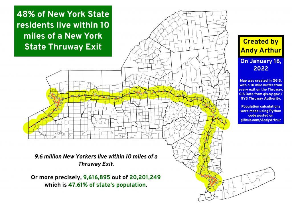
For about half of New York State residents, a Thruway Entrance is less than 10 miles away.
Old NY 10 running on the east side of Goodman Mountain couldn't have been in use very long as it's not seen on the 1907 USGS topographic maps and by the mid-1950s has already been by-passed in favor of the modern western alignment along the lake.
While more then 3/5th of the landmass in New York State is forested and roughly a quarter is farmed, many of the parcels are broken up by roads and houses. Even small gaps in natural cover can have significant impacts on wildlife. Most of state's largest parcels of unbroken cover is in the Adirondacks, though a few large parcels can be found in the Catskills and Allegany hills of Western NY. This data set also contains some data from watersheds in Northern Pennsylvania that feed into New York. From the New York Natural Heritage Program:
Although forests in the Northeastern US had been increasing in their extent since the early 1900s, more recently, we are starting to see this trend reverse,with development fragmenting and reducing the size of forests on our landscape. The objective of this project was to delineate road-less forest patches throughout New York State, based on the latest version of the National Land Cover Dataset(2016), and then to assess the condition of those patches within the Hudson River Estuary Watershed.
Data Source: New York Natural Heritage Program, New York Forest Patches, Natural Lands.