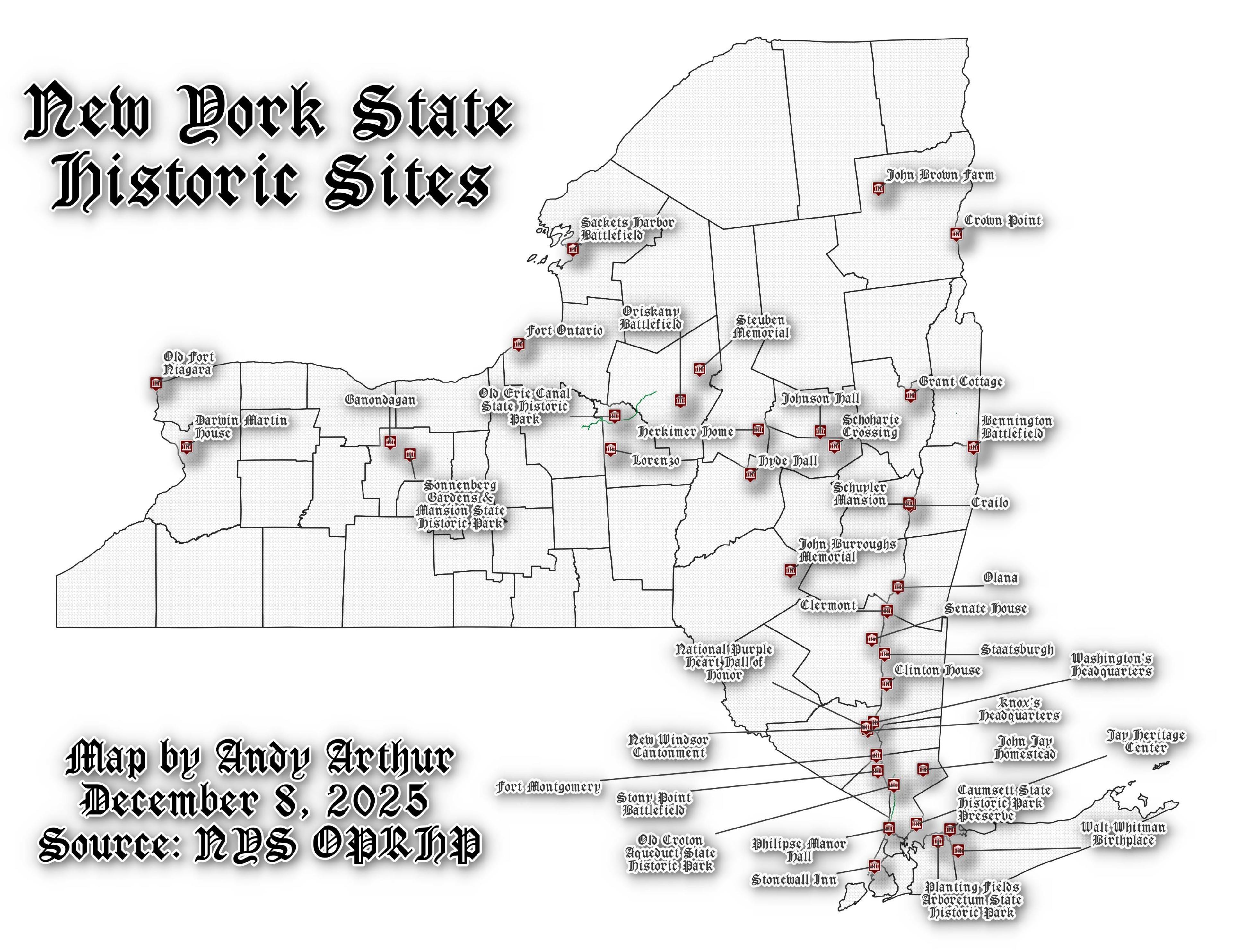
Map: Ketchumville State Forest

More about New York State...

New York is a state in the Northeastern region of the United States. New York is the 27th-most extensive, the 3rd-most populous, and the 7th-most densely populated of the 50 United States. New York is bordered by New Jersey and Pennsylvania to the south, and by Connecticut, Massachusetts and Vermont to the east. The state has a maritime border with Rhode Island east of Long Island, as well as an international border with the Canadian provinces of Ontario to the west and north, and Quebec to the north. The state of New York is often referred to as New York State to distinguish it from New York City.

Map: NYS Metropolitian Region
SVGZ Graphic: Burg vs Burgh
SVGZ Graphic: Center of New York Counties
SVGZ Graphic: Center of NY State
SVGZ Graphic: Change in Forests, 2001-2019
SVGZ Graphic: Counties of New York State
SVGZ Graphic: County-owned Lands in NY State
SVGZ Graphic: Elevation of New York
SVGZ Graphic: Elevation of New York - Area
SVGZ Graphic: How many cities the size of Manhattan can fit in this county?
SVGZ Graphic: Land Cover in Alabama
SVGZ Graphic: Largest Land Cover by Town
SVGZ Graphic: Largest private acerage owners in each county
SVGZ Graphic: Local Names for Valleys - NY - Dot
SVGZ Graphic: Lowest Named Elevation Places in NY State
SVGZ Graphic: Most Rural Zip Codes in New York
SVGZ Graphic: Nearest State / Province from This Part of the State
SVGZ Graphic: NY Counties Redrawn to Reflect Proximity to County Seat
SVGZ Graphic: party-congress
SVGZ Graphic: party-congress-1930
SVGZ Graphic: Percent of Town Developed
SVGZ Graphic: Percentage of Sedans that are Black
SVGZ Graphic: Physiographic divisions of NY
SVGZ Graphic: Regions around Cities
SVGZ Graphic: Rook Neighbors by NY Counties
SVGZ Graphic: The Road to the $15 Mininum Wage in New York
SVGZ Graphic: Where 366,00 New Yorkers Live Upstate
SVGZ Graphic: Year NY County Incorporated
Terrain Map: New York - New England 2D
Terrain Map: New York and New England Terrian
Thematic Map: Acres of Land Developed between 2001 and 2016
Thematic Map: Agricutural Areas in New York State
Thematic Map: Appellate Divisions of the New York State Supreme Court
Thematic Map: Buildings In The Capital Region
Thematic Map: Capital Region Municipalities
Thematic Map: Capital Region Villages
Thematic Map: Developed Areas in New York
Thematic Map: Developed Areas in New York State
Thematic Map: Eastern Continental Divide in New York State
Thematic Map: Elevation of New York State
Thematic Map: Forests in New York State
Thematic Map: Highest Populated Places in New York
Thematic Map: Judicial Districts in New York State
Thematic Map: Level 3 Eco Regions in New York State
Thematic Map: Median Household Income in New York State, a Hexagram
Thematic Map: New York Counties - Ranked by Median Slope
Thematic Map: New York State Population Density
Thematic Map: New York State Slope
Thematic Map: Percent of Town Landmass Developed
Thematic Map: Primary Direction of Hillsides in NYS - Aspect
Thematic Map: Type of County Subdivison in New York - Town, City, Bourgh, Reservation
Photo: Turbines
Photo: Exploring dirt roads on the Tug Hill Plateau
Photo: Exploring the back roads of Lewis County

Leave a Reply

Your email address will not be published. Required fields are marked *