Washington Park vs Lincoln Park, a size comparison
I was noticing how close in size both Washington and Lincoln Parks are in.
I was noticing how close in size both Washington and Lincoln Parks are in.
Yesterday I did a lunch time walk around Washington Park. It was a nice place to go for a stroll.
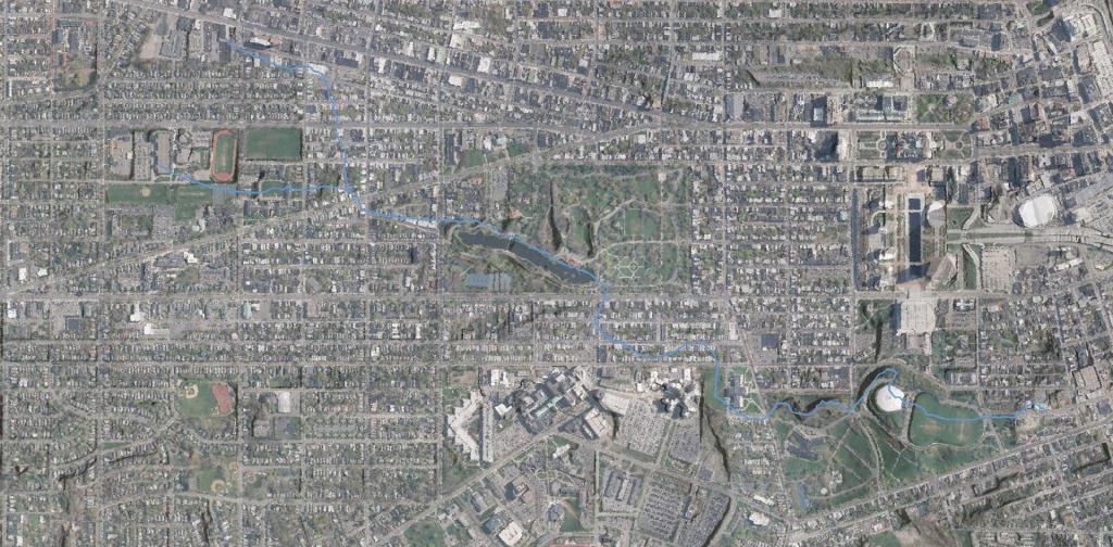
Today if you went Downtown you would be hard pressed to find much of the Beaver Kill or Beaver Creek. Most of it is buried in the Big C Pipe, although they are proposing to daylight part of it in Lincoln Park during the coming years. Probably the best place to see it would be in what is now Washington Park Lake.
Data Source: 1866 Beers Map of Albany from the New York Public Library, georefrenced, traced and overlaid on a contemporary aerial photo and LIDAR hillshade.
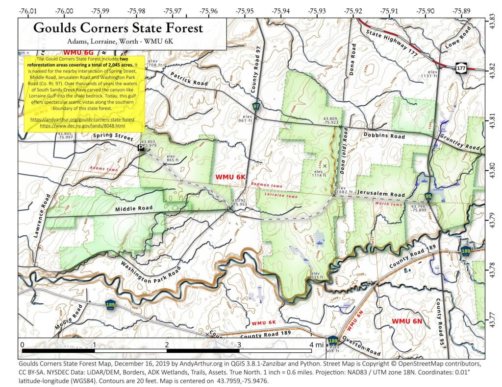
The Gould Corners State Forest includes two reforestation areas covering a total of 2,045 acres. It is named for the nearby intersection of Spring Street, Middle Road, Jerusalem Road and Washington Park Road (Co. Rt. 97). Over thousands of years the waters of South Sandy Creek have carved the canyon-like Lorraine Gulf into the shale bedrock. Today, this gulf offers spectacular scenic vistas along the southern boundary of this state forest.
https://andyarthur.org/goulds-corner-state-forest
https://www.dec.ny.gov/lands/8048.html
Cumberland is a city in and the county seat of Allegany County, Maryland, United States. It is the primary city of the Cumberland, MD-WV Metropolitan Statistical Area. At the 2010 census, the city had a population of 20,859, and the metropolitan area had a population of 103,299. Located on the Potomac River, Cumberland is a regional business and commercial center for Western Maryland and the Potomac Highlands of West Virginia.
Historically Cumberland was known as the "Queen City", as it was once the second largest in the state. Because of its strategic location on what became known as the Cumberland Road through the Appalachians, after the American Revolution it served as a historical outfitting and staging point for westward emigrant trail migrations throughout the first half of the 1800s. In this role, it supported the settlement of the Ohio Country and the lands in that latitude of the Louisiana Purchase. It also became an industrial center, served by major roads, railroads, and the Chesapeake and Ohio Canal, which connected Cumberland to Washington, D.C. and is now a national historical park. Today, Interstate 68 bisects the town.
The industry declined after World War II, which led much of the later urban, business and technological development in the state has been concentrated in eastern coastal cities. Today the Cumberland, MD-WV Metropolitan Statistical Area is one of the poorest in the United States, ranking 305th out of 318 metropolitan areas in per capita income
Block-level population density of Onondaga County from the 2010 full population count census. Densities are persons per square mile in the bold text. Clear blocks have no residential population. Washington Square and Northside has the most densly populated neighborhoods on average, but there are some highly populated blocks near Syracuse University and downtown, that are surrounded by commercial buildings, parking lots, and other non-residential buildings.