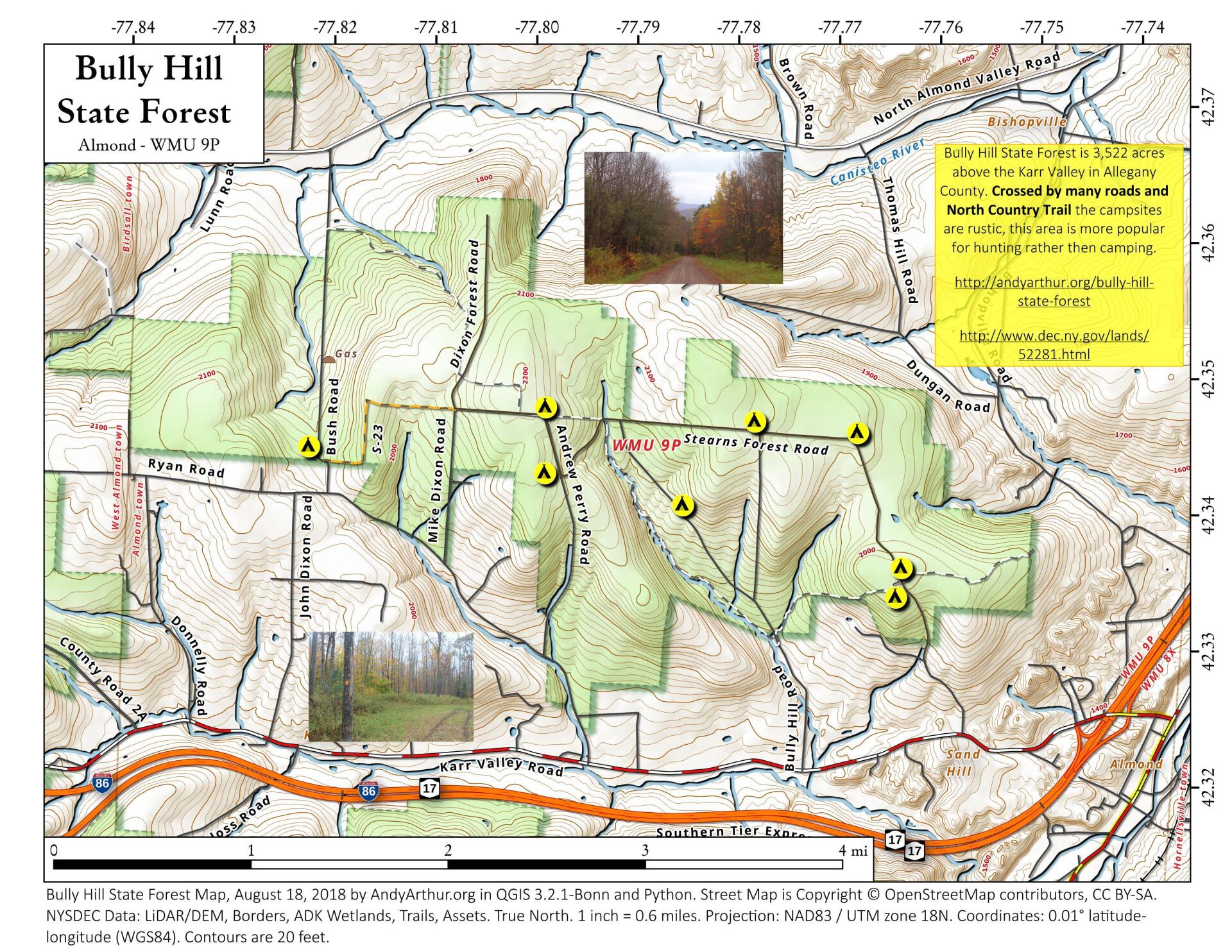
Map: Bully Hill State Forest

Download a High Resolution JPEG Image of the Bully Hill State Forest or an Adobe Acrobat Printable PDF of the Bully Hill State Forest.

Bookmark my free Interactive GPS Map for your phone:
https://andyarthur.org/ny
... shows your location as a blue dot in relationship to campsites, trails, state land. This online map requires cell service, won't work in remote country, so also bring a paper map.
Free Download of New & Historical USGS 1:24k Topograpic Maps
Interactive maps with backcountry and roadside camping: New York, Pennsylvania, West Virginia & Vermont. List of NYS DEC Lean-Tos and Firetowers.
Google Spreadsheet with Roadside, Primitive and Pay Campsites
More about Allegany County...
Allegany County is a county located in the U.S. state of New York. As of the 2010 census, the population was 48,946.[1] Its name derives from a Delaware Indian word, applied by settlers of Western New York State to a trail that followed the Allegheny River. Its county seat is Belmont.
Allegany County is in the southwestern part of New York State, along the Pennsylvania border. Allegany County does not lie along the Allegheny River, as its name would suggest. The highest point in the county is Alma Hill with an elevation of 2,548' above sea level. This is the highest point west of the Catskill Mountains in New York State. The highest point of Interstate 86 is located in the Town of West Almond with an elevation of 2,110'. This is also believed to be the highest point of any Interstate in the New York.
The Genesee River bisects the county from south to north. In June 1972 the remnants of Hurricane Agnes stalled over the area, dropping more than 20 inches (510 mm) of rain. There was memorable flooding in Wellsville, Belmont, Belfast and other valley communities of the county. The Genesee River is extremely popular with canoeists (as it was a favored route for Native Americans) and the river abounds in smallmouth bass, trout and panfish.
http://en.wikipedia.org/wiki/Allegany_County,_New_York
Maps and Interactives
Vandermark State Forest
Rushford Lake
Highland Landfill in Belmont – 1995 vs 2020
Cuba – Aerial Photos from 1995, 2002, 2007, 2012, 2016, 2020, 2023
Allegany County State Forests
Turnpike State Forest
Slader Creek State Forest
Rush Creek State Forest
Rattlesnake Hill Wildlife Mangement Area
Plumbottom State Forest
Palmer Pond and Turnpike State Forests
Klipnocky State Forest
Keaney Swamp Wildlife Management Area
Hiltonville State Forest
Gas Springs State Forest
Coyle Hill State Forest
Cold Creek And Lost Nation State Forest
Canacadea State Forest
Bully Hill State Forest
Bald Mountain State Forest
... photos, maps and other content from from Allegany County.